In brief: A weak front arrives in Houston this morning to drop humidity levels down for a couple of days. Beyond this, the region will see warm weather for the next 10 days, with sunny or mostly sunny skies. Really conditions won’t change much. If Houston’s weather were like this all of the time, Matt and I would be out of job. Or, in this case, a hobby. Have a great weekend!
Friday
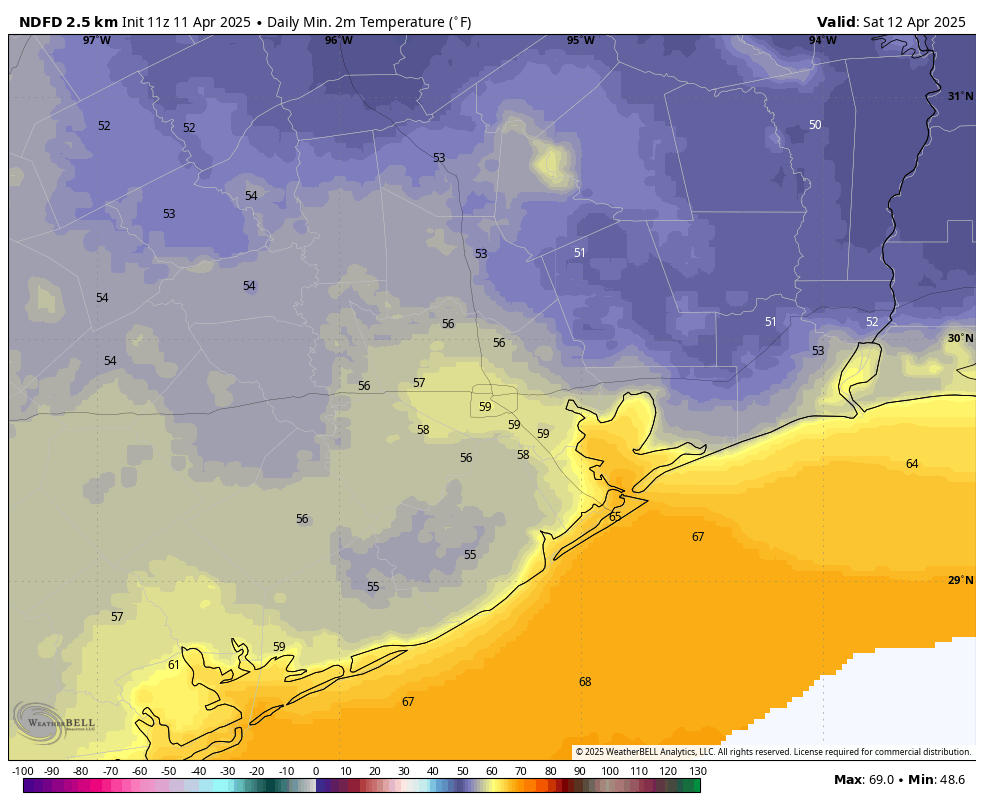
Temperatures are in the low 60s this morning, and we are again going to have sunny skies today. What will be a little different is winds, which will shift to come from the northeast this morning at 5 to 10 mph. This is due to the passage of a weak front that will move offshore, bringing dewpoints down into the 40s for today and Saturday before the onshore flow brings them back up. Highs today will reach the mid- to upper-80s in Houston. Lows should drop into the mid- to upper-50s for most locations, and this will be our coolest night for some time.
Low temperatures on Saturday morning will be the coolest of the forecast period. (Weather Bell)
Saturday and Sunday
This weekend looks to bring sunny weather into the Houston region should you have any outdoor plans. And really, you should. Look for highs in the low 80s with sunny skies on Saturday, and continued dry air. As light southerly winds return later in the day look for lows to only drop to around 60 degrees in Houston on Saturday night. Sunday will be a little less ideal, with southerly winds picking up to 10 to 15 mph, and it looks like we may see some gusts in the range of 25 mph. So expect higher humidity to go along with temperatures in the mid-80s. Lows on Sunday night will drop into the mid-60s.
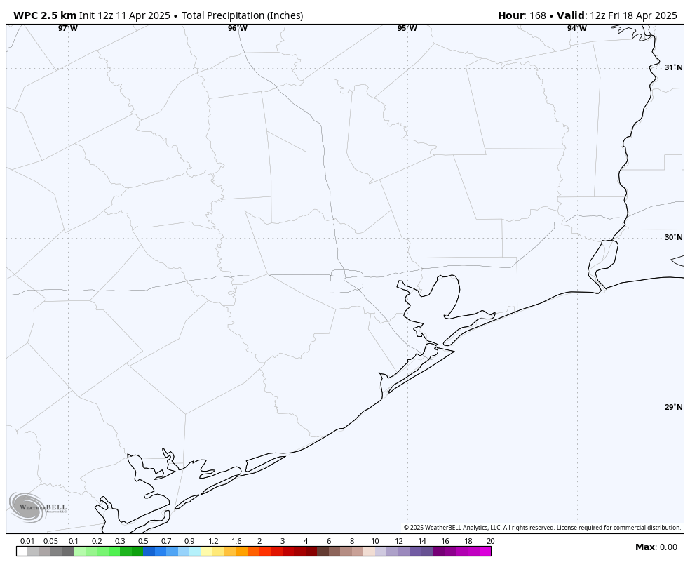
Here’s your rain accumulation forecast for now through next Friday morning. Pretty simple. (Weather Bell)
Next week
As Matt mentioned in yesterday’s post, next week’s weather looks to be more or less the same. Most days will bring highs in the 80s with nighttime temperatures in the 60s. We may push upwards toward 90 degrees by the end of the work week. Dewpoints are going to hover around the upper 50s to lower 60s which is a tad humid, but far from uncomfortable like we can see in Houston. Days should bring a few more clouds than this week, but we’re still going to see lots of sunshine. Rain chances look low until at least next weekend. Speaking of next weekend, I don’t yet have great confidence in the forecast for Easter Sunday, but highs in the 80s seem most likely. At this point, however, we cannot rule out a chance of showers.
To be honest, there is very little to discuss with respect to Houston’s weather forecast. We expect sunshine, warm and dry weather, and some ground ozone/air quality issues in the mornings and evenings over the next few days. Highs will be in the 80s with lows in the 50s and 60s. Beginning around Sunday, we’ll add some more humidity to the mix and slightly hotter weather with highs near 90 degrees by Monday and lows in the 60s. Overall, it looks great, albeit a little hotter than usual for April.
Our next meaningful rain chance likely does not come until the middle of next week, if then. More to come.
Nothing about this forecast on the surface is especially notable or alarming or fascinating. It’s simply a slightly above average forecast.
But what is somewhat notable about their forecast is some of the under the hood items they address. First, we are likely to be coming out of a La Niña event, something we discussed last back in February. But as the CSU team notes, we don’t know for sure if we’re headed for El Niño or ENSO neutral (La Nada) conditions. ENSO neutral summers combined with warm water temperatures “typically provides a more conducive dynamic and thermodynamic environment for hurricane formation and intensification.” In other words, hurricanes like those background conditions.
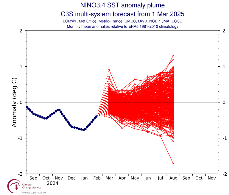
We do not yet have a “plume” from the C3S suite for April, but the March plume skewed slightly toward El Niño development.
Multi-system ensemble of various forecast models predicting a trend toward positive sea-surface temperature anomalies this summer, possibly giving a slight edge to a developing El Niño event. (Copernicus)
If we get to El Niño conditions by late summer or fall, that does not guarantee that conditions will shift to become more hostile to hurricane development. But that may take the edge off a bit. However, if we “hang” near the neutral line or even in weak La Niña territory, any hostile conditions may be apt to stay away, ensuring a busier season than usual.
In addition to the forecast for named storms and such, the CSU team also does try to convert that seasonal outlook to a prediction of U.S. landfall risk. Indeed, with a more active season expected, the odds of a U.S. landfall are also higher. They have a 51 percent chance of a major hurricane landfall on the U.S. coast, compared to a historical average of 43 percent. The odds on the East Coast are 26 percent, compared to 21 percent typically. And in the Gulf, the landfall odds between the Florida Panhandle and Brownsville are 33 percent versus a 27 percent average.
According to the CSU team, all model guidance is pointing to an above-normal season. Water temperatures remain well above long-term averages across the Atlantic. As we noted earlier this year, however, this is not last year’s Atlantic sea-surface temperature profile. But it’s still quite warm.
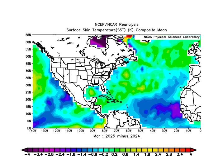
March 2025 minus March 2024 sea-surface temperatures, showing year over year warming in the Caribbean, Gulf, and mid-latitudes, but not in the tropical Atlantic. (NOAA PSL)
From the map above, you’ll notice that the eastern Atlantic has cooled markedly since last year, however the Gulf, Caribbean, and northern Atlantic Ocean are all warmer. The fire that was burning all last summer in the eastern Atlantic is still smoldering, but it has been somewhat extinguished. The Gulf and Caribbean are another matter. The Gulf is warmer than 2024 by a good bit but still lags 2023. While the Caribbean was warmer than 2024 in March, it has since cooled some in April, taking it back under 2024 levels. Water temperature conditions can change quickly, but the bottom line is that the Atlantic, with the exception of the eastern basin are in the upper echelon of warm years at this point. The warmer overall waters in March in the eastern North Atlantic (north of the tropics), along with the warm Caribbean do correlate to active hurricane seasons.
The bottom line is that the underlying data support the idea of an active hurricane season — but not to the levels feared last year. But there aren’t very many red flags at this time arguing against that outcome. At least last year, we had the expectation of a developing La Niña to help grease the wheels a bit, and a slow development could have slowed the hurricane season a bit. This year? There’s no real glaring red flag that says the season will bust. But hurricane seasons always have surprises. Hopefully this year’s involves calm.
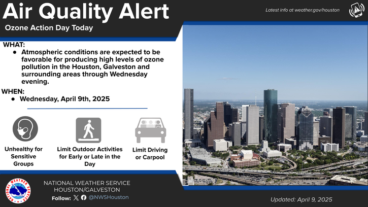
In brief: Other than some periods of poor air quality, the forecast for Houston is about as perfect for springtime as it gets with sunshine and low humidity through the weekend.
Today through Sunday
This is really going to extend an incredible stretch of sunny weather here in Houston. Very few clouds are expected over the next 5 days, with sunshine each day. You will see and hear about air quality advisories. The plentiful sunshine tends to interact with pollutants from cars and petrochemical facilities to produce ground ozone. You can read more about this here, but suffice to say, there will be periods of unhealthy air quality in the morning or evening, especially today, tomorrow, and Friday.
(NWS Houston)
Temperatures will flop around a bit. We’ll do low 80s today, mid-80s tomorrow and Friday, low to mid-80s on Saturday, and then mid to upper-80s on Sunday. Morning lows will be in the 50s or 60s. Overall, this will also be a fairly pleasant, dry air mass. Humidity will increase some this weekend but not to levels that would be deemed uncomfortable.
Next week
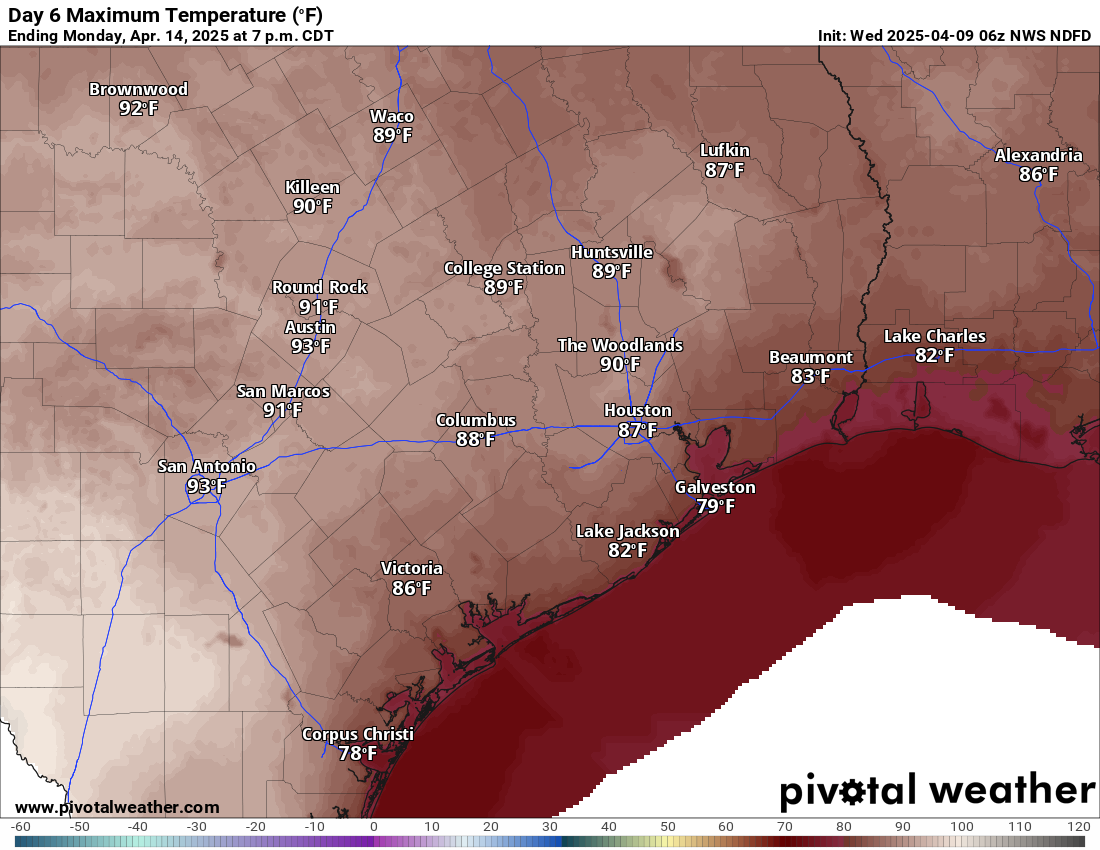
Even next week the pattern doesn’t change a whole heck of a lot for Southeast Texas. We should see more humidity, a little bit more in the way of cloud cover, and eventually some additional storm chances. Those probably don’t become really notable until later in the week. Temperatures should start to increase some and push 90 degrees by Monday or Tuesday.
Temperatures could begin to push 90 degrees by early next week. (Pivotal Weather)
Bottom line: Enjoy this week’s stretch because you never know how many more like this we’ll get before summer sets in.
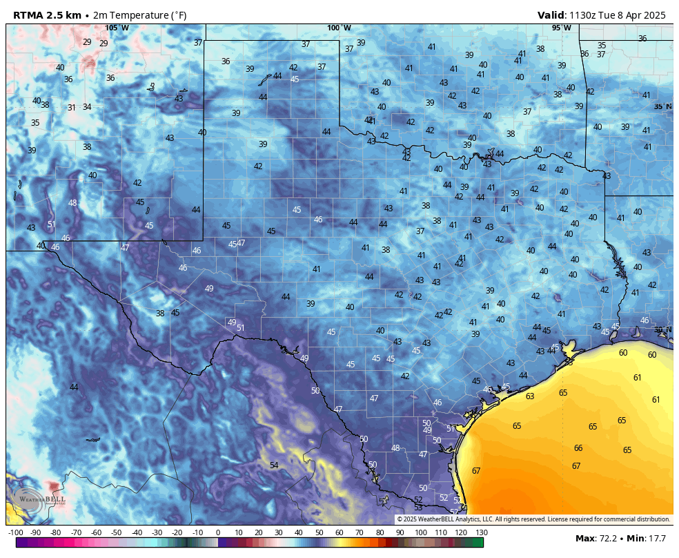
In brief: It’s rather cold across the state of Texas this morning, with nearly all of the state in the 30s and 40s outside of The Valley. Because we’re nearing the middle of April, the cold weather will not last, and indeed I don’t think it will get this cold in Texas for the next six months. Expect warmer temperatures for the rest of the week, but high humidity will remain at bay for awhile.
It is a cold morning across Texas. (Weather Bell)
Midway through spring
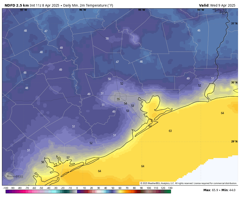
Spring is by no means over for the greater Houston area, as temperatures outside this morning demonstrate. Pretty much the entire metro area outside of areas far inland (Conroe, 38 degrees) and Galveston (56 degrees) has fallen into the low- to mid-40s this morning. This is by no means extraordinary, as the record low temperature for today in Houston is 35 degrees, set back in 1971.
However, temperatures this morning are still running about 10 to 15 degrees below normal for this time of year, and looking ahead at the next two weeks I do not see another strong front in the cards. Therefore, for the urban core of Houston and areas closer to the coast, I expect that this morning may well be the final morning in the 40s of this season. We may not see its like again until October, or even November.
Tuesday
Miracle of miracle, the winds this morning are calm across the region, and are likely to remain so today. With sunny skies we should warm into the mid-70s this afternoon, with continued very dry air. Seriously, today is going to be one of the nicest days of the year, with exceptional weather. Lows tonight in Houston will drop into the lower 50s for most locations. Areas west and north of the city should dip into the upper 40s once again.
Inland areas to the west and north of Houston will have another shot at the 40s on Tuesday night. (Weather Bell)
Wednesday
Wednesday will be a slightly warmer, and a slightly more humid version of Tuesday. We are talking high temperatures of about 80 degrees, and lows dropping to about 60 degrees on Wednesday night. Winds will have turned to come from the south, at perhaps 5 to 10 mph.
Thursday, Friday, Saturday, and Sunday
We should see sunny skies throughout the rest of the week, with high temperatures varying between 80 and 85 degrees. A weak front arrives on Friday morning to knock some of the humidity out of the air, but overall with dewpoints in the 40s and 50s the air is going to feel modestly dry. Nights should, generally, fall to around 60 degrees with inland areas a bit cooler and the coast a bit warmer. By Sunday we may see southerly winds become more pronounced, with gusts of 20 to 25 mph possible.
Next week
Next week should be a little bit warmer, with a few more clouds. I think we will be in the 80s for the most part, with nights in the 60s. There will be some humidity, sure, but it won’t feel like Houston humidity can during the depths of the summer. As for rain chances, overall chances are quite low until next Thursday or Friday, at least.