With drought on our Western doorstep, Houston set for drenching rains this week

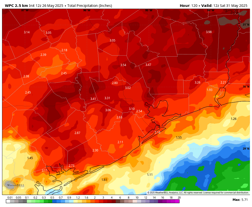
In brief: We hope everyone is enjoying Memorial Day weekend, and we join in remembering all of the US military personnel who gave their lives for this country. The weather should be fine for outdoor ceremonies today. However, Houston will face a series of storm systems this week, including a potentially impactful event tonight. Most of the region should see some much-needed rainfall during the next seven days.

Drought conditions as of May 20, 2025. (US Drought Monitor)

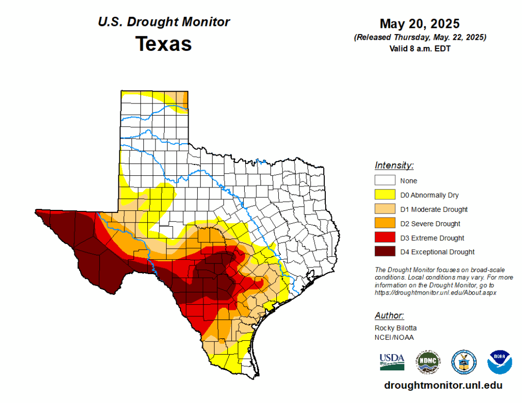
Not a drought, but close

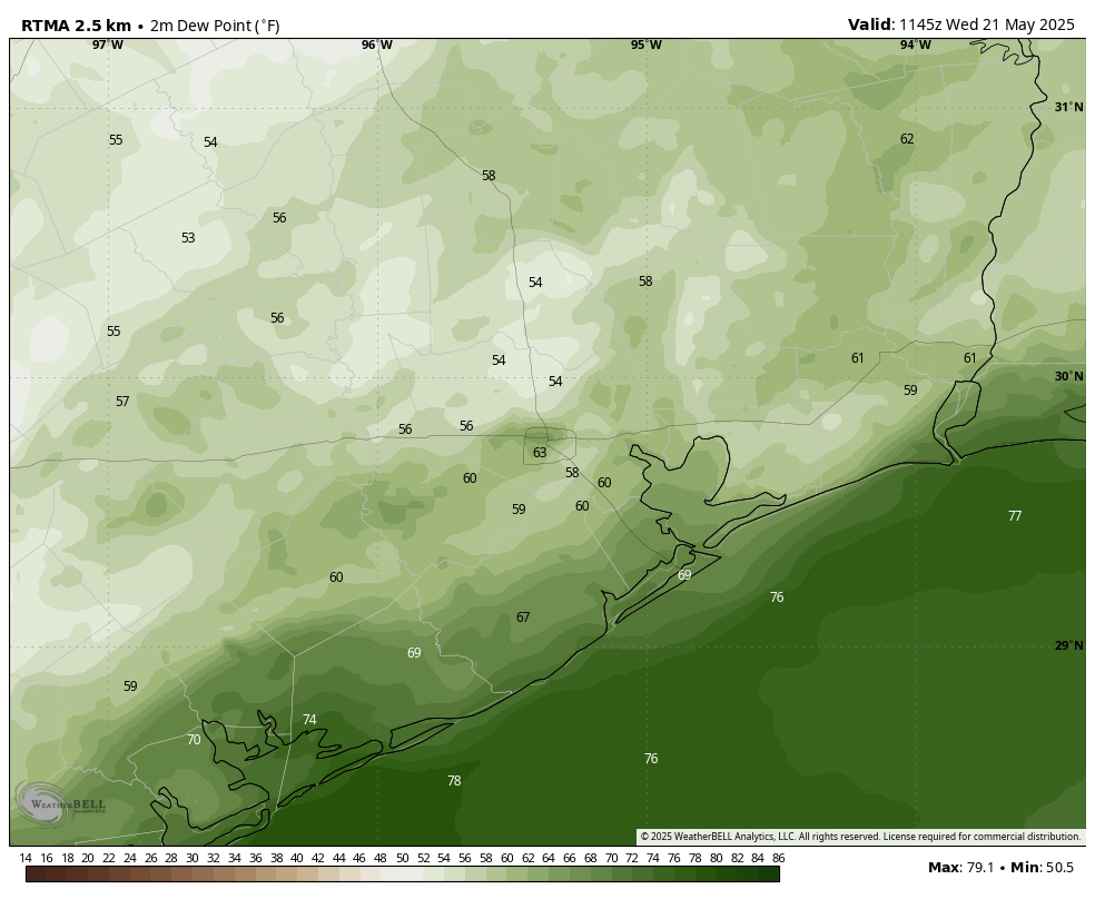
The second half of spring has been fairly dry. Drought conditions are much more acute in central and West Texas, where an exceptional drought has developed ahead of summer. Although Houston is not in a drought, abnormally dry conditions have moved into Brazoria and Waller Counties, with a moderate drought southwest of there. Now that we are approaching the hottest and often driest part of the year, these drought-like conditions would spread into Houston rapidly in June, in the absence of rain. However, as the forecast for this week indicates, that is now unlikely to happen.

Memorial Day and night

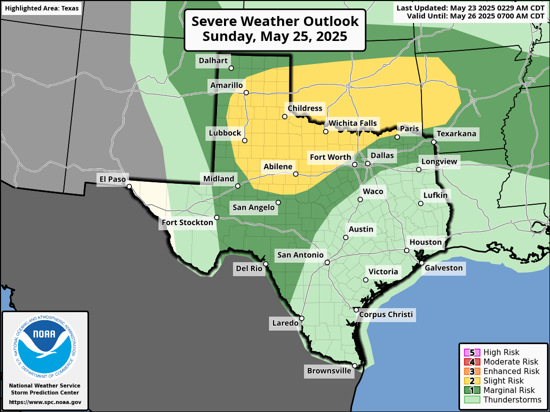
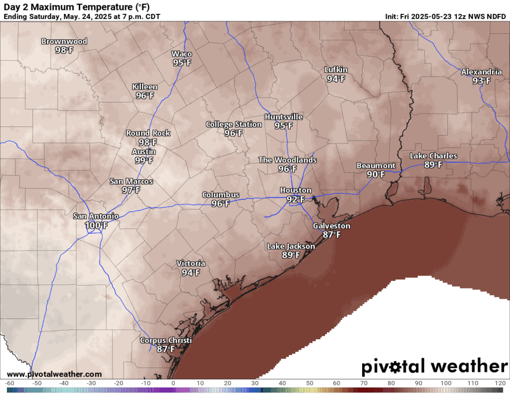
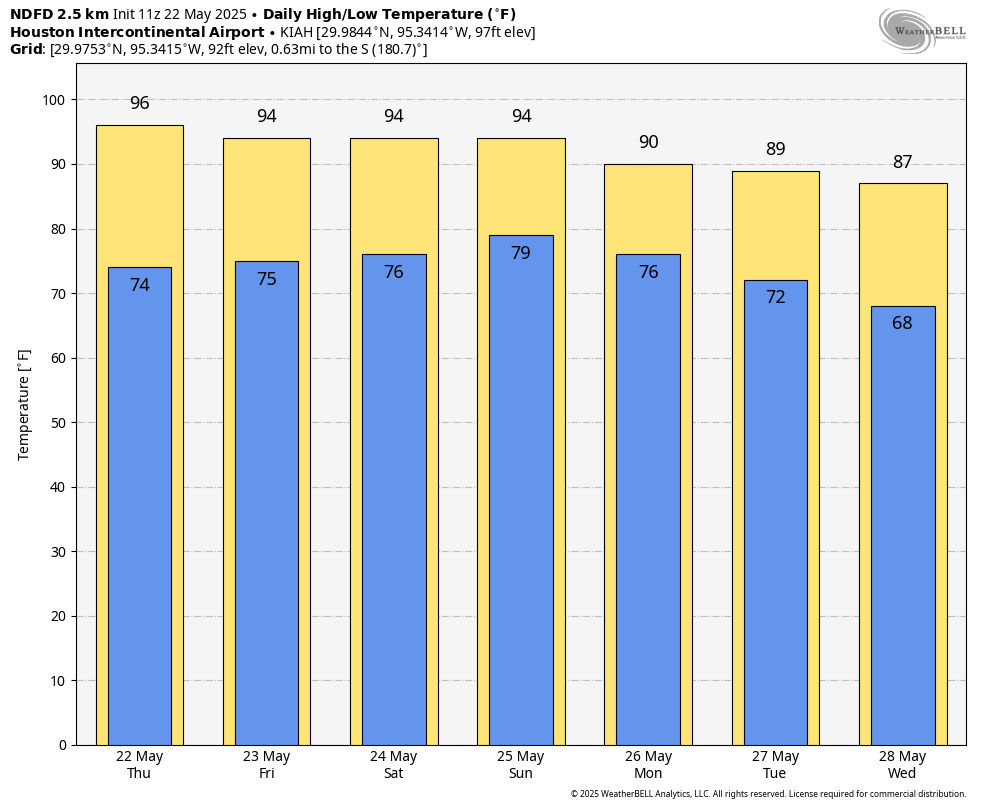
A series of disturbances will impact our area’s weather this week, and the first of these is already propagating to the north of College Station this morning. I anticipate that the majority of this activity will remain north of the Houston metro area, likely along Highway 105 and points north in Montgomery County. But we can’t rule out some activity further south. Skies in Houston should be mostly sunny today, with highs in the low 90s and gusty southerly winds. Humidity will, accordingly, be high.

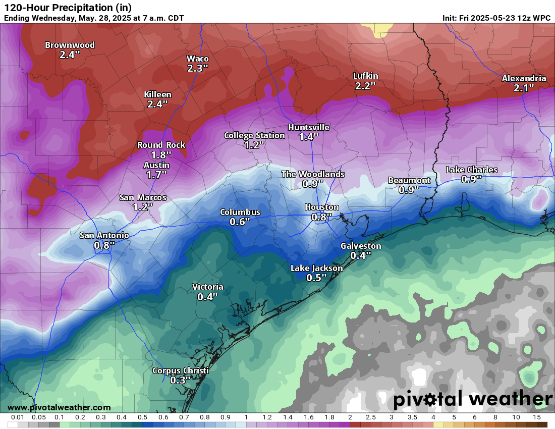
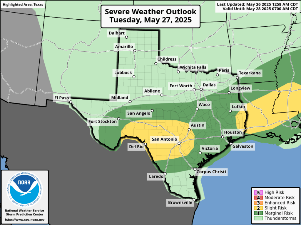
Another disturbance should move into the region this evening, perhaps not reaching Harris County until midnight or later. This has the potential (and the emphasis here is on potential, given the uncertainty) to bring more widespread showers and thunderstorms into the entire region, all the way down to the coast. The most likely time for significant activity is between midnight tonight and noon on Tuesday. Some hail and damaging winds will be possible during thunderstorms, and most locations should pick up 0.5 to 2 inches of rain.

Severe storm outlook for Tuesday. (NOAA)

Tuesday, Wednesday, and Thursday

After these storms we’ll remain in an unsettled pattern for the remainder of the week. Each day will have a healthy chance of showers and thunderstorms, perhaps on the order of 50 percent. Accordingly, high temperatures should be in the upper 80s with partly to mostly cloudy skies. To be clear, these days won’t be total washouts. But pop-up showers will be possible at any time.

Friday

By Friday the overall pattern may start to change a little bit, but with an unsettled atmosphere lingering there still will be a decent chance of rain, in the 30 to 50 percent range. Expect partly sunny skies and highs in the upper 80s.

NOAA rain accumulation forecast for now through Friday night. (Weather Bell)

Saturday, Sunday, and beyond

By this weekend we should see partly to sunny skies, with highs around 90 degrees. Rain chances won’t go away entirely, but they look to be on the order of maybe 30 percent daily. Next week likely brings us back into the lower 90s, with mostly sunny skies and little to no rain. So stock up this week!

A mostly fine start to Memorial Day weekend in Houston, with slightly higher rain chances on Monday

In brief: The holiday weekend should be mostly fine (albeit hot) in Houston. Rain chances will rev back up a bit late Sunday night and Monday morning and again deeper into next week. For now, Memorial Day Monday looks unsettled but perhaps not a total loss.

Memorial Day Weekend

Let’s jump right into the big holiday weekend. First off, if you have plans in the Houston area or on the coast today and tomorrow, you’re more than likely going to have no issues whatsoever. There could be a passing shower or storm in the region, but it would most likely be extremely isolated. The vast majority of us should see absolutely nothing.

If the odds of rain on Friday and Saturday are something like 5 percent, then I think Sunday’s odds nudge up to about 10 percent. Again, the vast majority of the area will be fine on Sunday. But there should be at least a few more pop-up showers or a very, very isolated thunderstorm.

So what about Monday? Well, that’s the trickiest day of them all this weekend. Models have been pretty consistent about trying to bring a cluster of thunderstorms in from the north on Sunday night into Monday morning. We could then see a break in the action followed by another round perhaps on Monday night. We’ll see if that’s how it unfolds. Eric or I will throw an update out there on Monday morning with the latest thinking. I would not postpone any plans at this point, but I’d be mindful that the chance of rain is highest on Monday.

Potential rainfall through Tuesday night. (Pivotal Weather)

Region-wide holiday weekend weather

If you’ll be traveling across Texas this weekend, there should not be a whole heck of a lot to bother you today or tomorrow. Isolated storms could be on the stronger side between the Permian and the Panhandle. And there’s a slight (2/5) risk of severe storms near Wichita Falls on Saturday.

Sunday is a little more interesting with the potential for more severe storms, especially from the Caprock into North Texas.

Severe storms are possible in parts of West and North Texas on Sunday. (NOAA SPC)

The remnants of those storms are what we could see in the Houston area late Sunday night or Monday morning.

And then for Monday, that chance of severe weather moves more into Hill Country and Central Texas up through DFW. Basically, between Houston and Dallas, there will be some severe risk Monday afternoon and evening.

Severe risks shift a little south and east on Monday. (NOAA SPC)

Memorial Day Weekend has had a history of flash flooding in Texas. At this time, the risk of flooding looks to be about average given the forecast; there are no significant flash flooding concerns right now.

Holiday weekend temperatures

As for the temperatures? They look hot. The combination of heat and humidity will make it feel like 100 to 105 degrees at times tomorrow through Monday. Actual highs will be in the mid-90s, with morning lows in the upper-70s. It will be cooler by day closer to the coast and a bit hotter farther inland.

High temps will range from the upper-80s at the coast to mid-90s inland, with heat index values of 100 to 105 degrees through Monday. (Pivotal Weather)

Next week

Temperatures will back down a bit due to clouds and rain chances next week. While it won’t rain everywhere or every day, there will be a good chance of rounds of thunderstorms throughout the week.

Houston will be hot and sunny into the holiday weekend before our pattern turns more unsettled

In brief: Houston’s weather will be mostly hot and sunny through Sunday. However, by Memorial Day our pattern should start to turn a little bit more unsettled, leading to cooler days with better rain chances for most of next week.

High School graduation weather

Many, but certainly not all, area high schools will hold their graduation ceremonies this weekend, when we have few weather concerns aside from the warm temperatures. Among the graduations will be an outdoor event for my youngest daughter, Lily. Both of our children have been enrolled in Clear Creek Independent School District for the better part of two decades, and it is bittersweet to contemplate the end of their school days. By and large their experience has been wonderful, with several great teachers along the way to provide wisdom, and love, and inspiration.

Amanda and I are grateful for our daughters’ public school education, and all the teachers and janitors and bus drivers and clerks and administrators who work so hard to help bring our children up. You strengthen our community immeasurably. And to all the graduates I would say that the world is kind of a mess, and we could use your help to build a brighter future. Best wishes, and the greatest of luck to you all.

Thursday will be plenty hot in the Houston region. (Weather Bell)

Thursday

In contrast to Wednesday morning, it is muggy outside this morning, with temperatures having fallen only into the mid- to upper-70s across the region. Skies will gradually turn sunny today, and this will allow high temperatures to reach up into the mid-90s. Winds will generally be light, from the east. There is a very slight chance of some showers near the coast this afternoon, but the overall odds are probably on the order of 10 percent. Expect another muggy night.

Friday

This will be another hot and mostly sunny day, with temperatures in the mid-90s again. Winds will again be fairly light, generally from the southeast.

Saturday

The first part of Memorial Day Weekend will bring more of the same, albeit with some subtle changes. One is that highs may be a degree or two cooler. The other is that southeasterly winds should be a little more pronounced, perhaps gusting up to 20 mph or higher. Nights remain warm and muggy.

Sunday

This will be another mostly sunny day, with highs likely in the lower 90s. By Sunday afternoon or evening there will be a slight chance of showers or thunderstorms as the atmosphere turns a bit more disturbed, but I would not put the odds of seeing precipitation at higher than 10 percent. It will be another gusty day, with winds from the southeast possibly reaching 25 mph or so.

Houston should end May on the cooler side of things. (Weather Bell)

Memorial Day and beyond

A more unsettled pattern looms for next week, likely beginning on Memorial Day. Overall we will see increased cloud cover, higher rain chances, and cooler temperatures for much if not all of next week. I’m hopeful that most of the area will pick up between 0.5 and 2 inches of rainfall, which most of the region needs after a dry May. Daytime highs will likely vary between the mid-80s and lower-90s depending on the extent and timing of rainfall. Nighttime temperatures will be a bit lower as well, dropping into the lower 70s later in the week. If we’re lucky, this late spring-time weather will get our soils get ready for the depths of summer, which lie just around the corner.

A mixed bag for Memorial Day weekend, and a pattern change for next week

In brief: We’ll see a short reprieve in humidity today, but then we are back to hot, and mostly sunny weather through Saturday. The second half of Memorial Day weekend could see the onset of some scattered showers, and by next week a pattern change should bring cooler temperatures and more widespread precipitation.

Dry air (dewpoints in the 50s) has filtered into much of Houston this morning. Alas, it won’t last. (Weather Bell)

Front status

A weak front moved into Houston overnight. It produced some stray showers and thunderstorms near downtown Houston and the Liberty area, but for the most part it was a dry passage. The front has now stalled near the coast and should allow for showers (mostly offshore) this morning before lifting back north as a warm front. Therefore, if you’re enjoying the slightly lower humidity levels this morning, don’t get too attached. Humidity levels will begin to climb this afternoon, and we’ll be back to sticky status this evening.

Wednesday

Skies will be mostly sunny for most of Houston today, with high temperatures in the low 90s. Winds will start out from the northeast this morning, but return to come from the southeast by this afternoon or evening—hence the rapidly recovering humidity levels discussed above. There likely will be some showers offshore, and a few of these may impact coastal areas today, but most likely they mostly remain over the Gulf. Lows temperatures tonight will drop into the mid-70s.

Thursday and Friday

These will be a pair of mostly sunny and humid days, with high temperatures in the low- to mid-90s for most locations and nights in the 70s. Rain chances are near zero. Winds from the southeast, generally, will be light.

Memorial Day weekend

It’s hard to believe we are already at the Memorial Day weekend stage of things, but here we are. Saturday should, more or less, see a continuation of the hot, humid, and mostly sunny weather of Thursday and Friday. Sunday may see a few more clouds, but will still be rather hot and humid. There may be a 20 percent chance of rain. By Memorial Day, however, we are likely to see the impacts of an advancing front. Highs may be around 90 degrees, with partly to mostly cloudy skies, and perhaps a 50 percent chance of light to moderate showers.

We’ll be warmer this week before temperatures in the 80s next week. (Weather Bell)

Next week

The details remain sketchy, but that front is likely to move into Houston and bring a period of moderately cooler and wetter weather. Most of next week should see highs in the 80s and lows in the 70s, with healthy rain chances. It’s difficult to pick a day with the greatest likelihood of rain, but we do look to be headed to a pattern in which showers are more abundant. We could use the break after a mostly hot, and mostly sunny May so far.