In brief: The next 12 to 24 hours will bring the potential for severe weather into the greater Houston region. Impacts include heavy rainfall that may lead to street flooding, damaging winds, large hail, and potentially tornadoes. Please be weather aware.
So far, today, the Houston region has been spared direct impacts from severe weather. The storms have remained well north and west of our area. However, that is likely to change in the next few hours as a line of storms, now impacting the College Station areas, is advancing from the west.
These storms will likely reach the northern half of the Houston area this afternoon and early evening. They will bring all of the threats described above, and may make a mess of the Tuesday evening commute for areas along and north of Interstate 10. Not everyone will experience strong storms, but the risk is there.
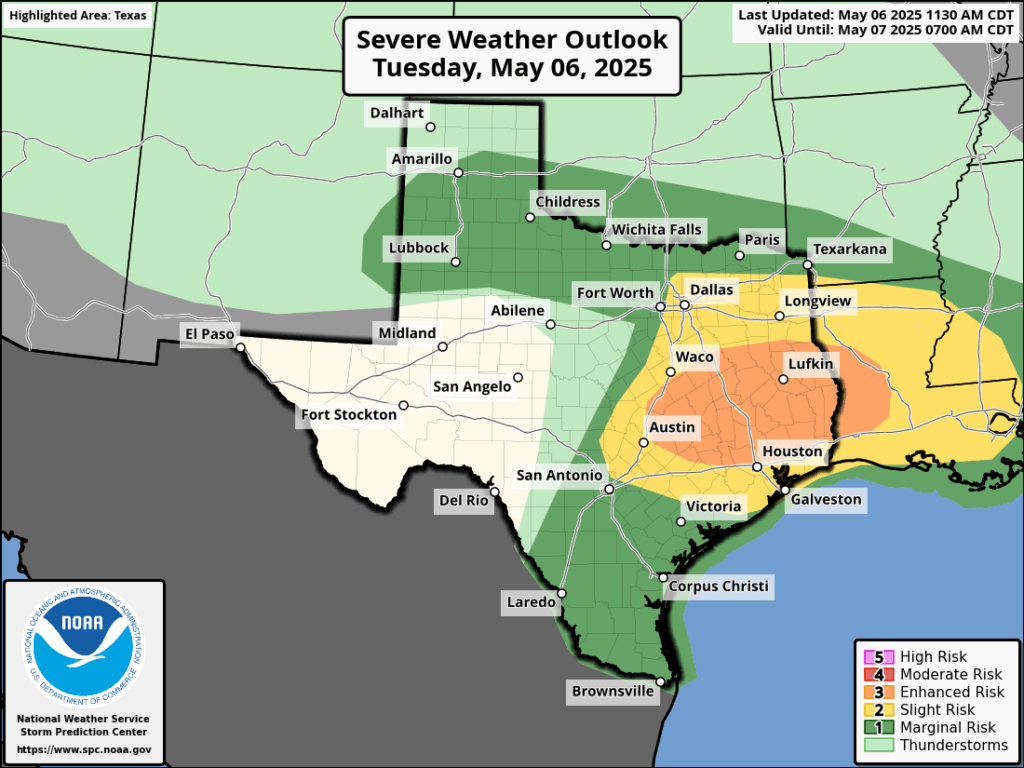
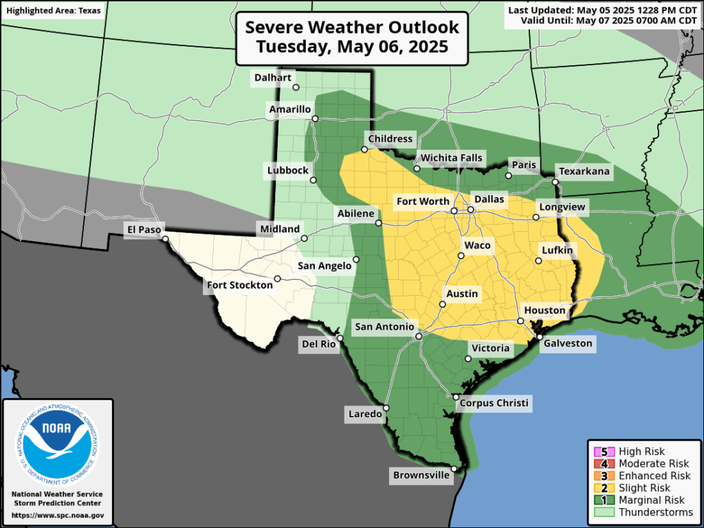
There is an “enhanced” risk of storms for areas along and north of I-10 later today. (NOAA)
This evening, and into Wednesday morning, these storms will probably spread across the entire region, including into coastal counties. The storms will lose some of their severity tonight, with the loss of daytime heating. This will diminish the threat of tornadoes and hazards such as damaging winds and hail. But the potential for strong thunderstorms and heavy rain will persist.
By Wednesday morning the majority of action will likely have shifted to the coast, or possibly be pushed offshore. Even so, you’ll want to remain weather aware as you get up and about on Wednesday morning.
Just to repeat myself here: Not everyone is going to be bombarded by severe weather, but the atmosphere above our region appears to be primed for storms during the next 12 hours or a little longer. Please remain weather aware this afternoon, evening, and on Wednesday morning.
In brief: Today’s post discusses our storm expectations for the next two days, with at least three distinct waves of severe weather possible for various parts of the Houston metro area. The bottom line is that it is important to remain weather aware through Wednesday.
Stormy pattern
A sharp disturbance in the upper atmosphere will provide lift needed to support unsettled weather from today through Wednesday across the Houston region. Areas along and north of Interstate 10 will be most favored for severe storms today, but we cannot rule out strong thunderstorms anywhere in the region. Among the risks we are tracking:
Heavy rainfall with high rates. Most of the greater Houston area is likely to receive 1 to 2 inches of rain, but there will be greater totals in some locations, and rain will be falling quickly enough to back up streets. For this reason we have put a Stage 1 flood alert in place through Wednesday evening.
Tornadoes. The atmosphere, with plenty of instability as well as available energy (CAPE), will be capable of forming tornadoes. If they form, they could become fairly powerful tornadoes given the atmospheric conditions.
Large hail. With previous storms we have already seen quarter-sized hail of late, and the atmosphere will be capable of supporting more large hail over the next two days.
Damaging winds. Within stronger thunderstorms there will be the potential for damaging, straight-line winds. If possible, batten down loose outdoor items that don’t have much heft.
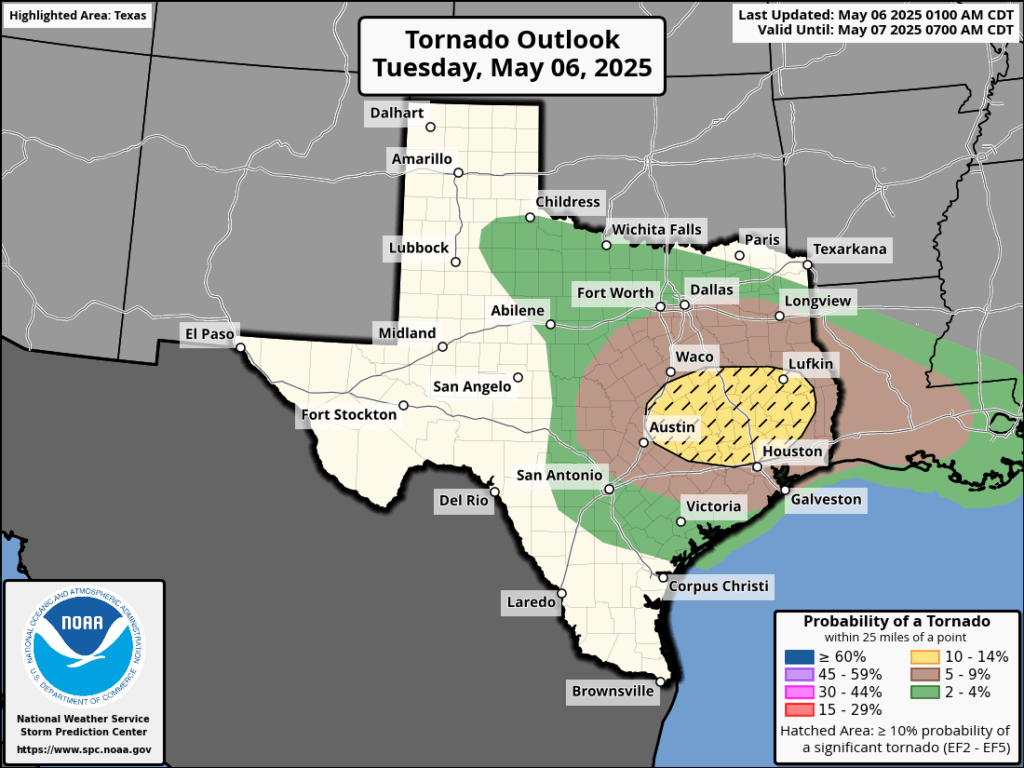
Tornado outlook for Tuesday and Tuesday night. (NOAA)
Timing of storms
Your best weapon for timing storms over the next two days will be a good radar app (RadarScope is one we like) to determine conditions nearby your location. However, generally, we expect a fairly calm morning. After that we should see at least three waves of storms:
Round one: By late Tuesday morning a line of storms, very likely with severe storms embedded, will be nearing the College Station area. This line should move into Montgomery County and points north by around noon, affecting the I-45 corridor (I’m concerned about areas including The Woodlands, Conroe, and Huntsville). At this time, we think most of these storms will be along and north of Interstate 10, but again we cannot rule out impacts further south, and closer to the coast.
Round two: Conditions may then calm down for a few hours this afternoon and early evening. However by around sunset I expect another line of storms to approach the Houston region from the northwest. I expect these to advance into the Houston metro area between 8 pm and midnight, but they may peter out before reaching the coast.
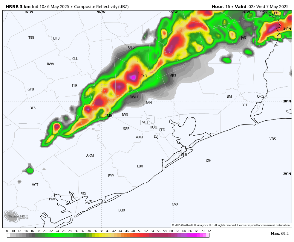
A second line of storms could advance into Houston this evening, around sunset, from the northwest. (Weather Bell)
Round three: If you live near the coast you may be wondering, are we not going to see anything from all of this mess? Well, it’s possible that areas south of Interstate 10 will not see much action on Tuesday. However, most of our guidance shows another round of storms developing to the southwest of the region and advancing into the city. It appears as though these storms will reach the southern portion of the Houston metro area early on Wednesday morning, spreading into much of the metro area. Again, these storms also have the potential to produce severe weather and could make for a messy commute on Wednesday morning.
After this we may see additional rounds of development later on Wednesday, but nothing quite as severe. We shall see.
Tuesday and Wednesday
Temperatures on both days should be in the low- to mid-80s, with partly to mostly cloudy skies. Even when there aren’t storms, on Tuesday in particular, there will be a fairly pronounced southerly wind with gusts up to 25 mph or so. Nights will be warm.
Thursday and Friday
Although likely not severe, the rains may linger into Thursday as a weak front pushes into the area. Expect partly sunny skies on Thursday, with highs in the mid-80s, and mostly sunny skies on Friday with a high of around 80 degrees. With slightly drier air, we should see nighttime temperatures drop into the 60s.
We should have another exceptional weekend. Although I don’t expect the air to be as dry as last weekend, it still should be reasonably pleasant with highs around 80 degrees, or just a bit above that, and lows in the vicinity of 60 degrees in Houston, with a smattering of 50s possible for far inland areas. Sunshine will be abundant, with rain chances near nil.
Next week
Most of next week looks mostly sunny and hotter, with highs possibly reaching 90 degrees by mid-week. It might start to feel a bit like summer around these parts, so enjoy the weekend.
Next update
We will post again on this site no later than shortly after noon.
In brief: Storms are firing up to the west of Houston this afternoon, and the region will face an unsettled pattern through Wednesday morning, at least. This post describes our latest thinking on timing and impacts from these storms.
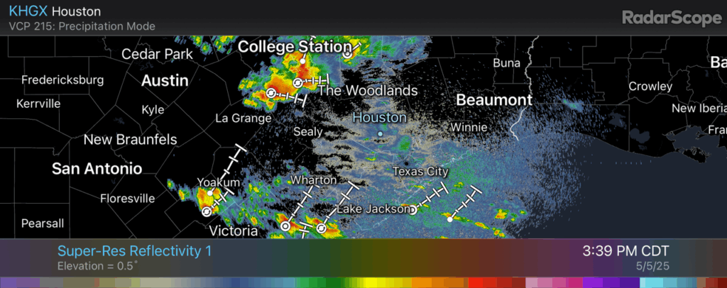
Good afternoon. Some fairly strong thunderstorms have developed near Brenham, and they are part of a system that is slowly moving to the east, and therefore toward the Houston metro area. I have some doubts about how much of this activity is going to hold together later this afternoon, but it is possible that some parts of the Houston region, including Montgomery County, will experience thunderstorms late this afternoon or this evening before midnight. After this we should experience a reprieve over night.
Radar reflectivity at 3:39 pm CT Monday. (RadarScope)
Tuesday and Wednesday
It is difficult to forecast the next couple of days with high confidence, so I’m going to share what we’re thinking now. But this is a fluid situation. (Both literally and figuratively). Tomorrow morning a fairly strong line of storms is likely to develop along the I-35 corridor around sunrise and then progress eastward across the state. A lot of our modeling suggests this line of storms will remain rather strong as it reaches I-45 late during the morning or around noon-ish. All of the threats are in place here: heavy rainfall, damaging winds, hail, and possibly tornadoes.
Here’s the tricky part. I’m fairly confident in strong storms for places like College Station and Huntsville, but the further south one goes, the less chance of inclement weather. It is possible that much of Harris County, and points south, see only scattered showers and thunderstorms on Tuesday, rather than a seriously disruptive and severe event.
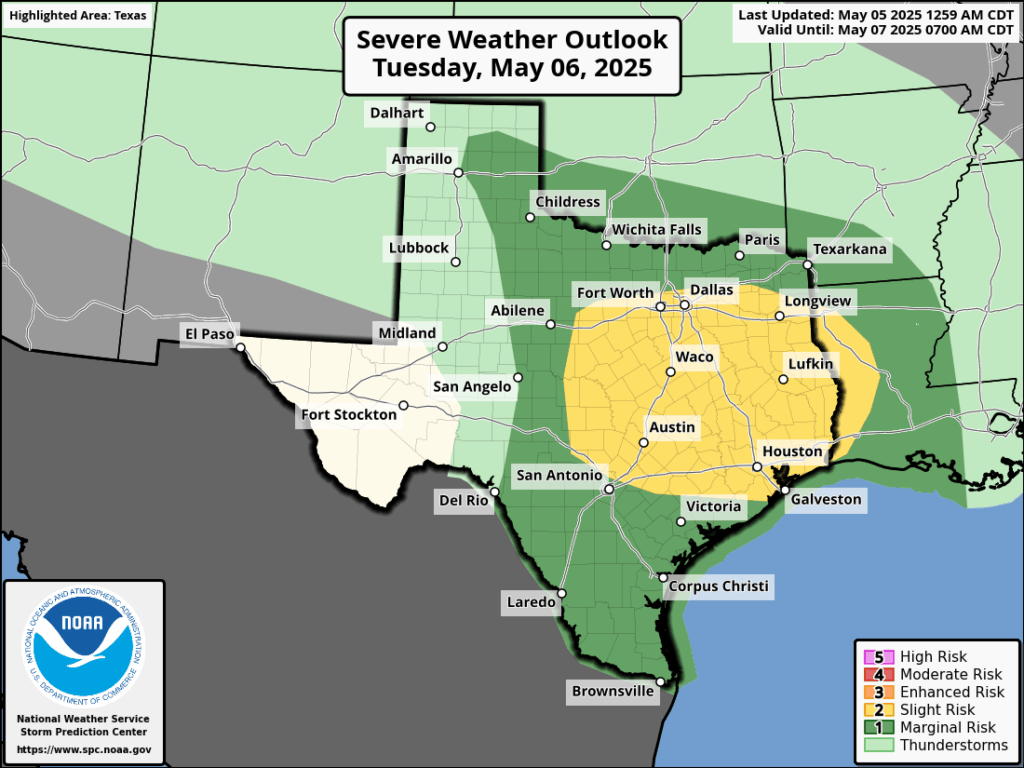
Severe weather outlook for Tuesday and Tuesday night. (NOAA)
However, that won’t be the end of it. The atmosphere will be supportive of a second round of showers and thunderstorms that are more likely to impact central and southern regions of the Houston area. Whether this occurs late on Tuesday evening, overnight, or on Wednesday morning simply is not something I can say with confidence right now.
The bottom line is that from now through Wednesday morning you should be prepared for the possibility of strong thunderstorms and heavy rainfall. We have put a Stage 1 flood alert in place to account for street flooding, but there is also the threat of hail, damaging winds, and tornadoes.
In brief: Monday will be calm, but you should anticipate the potential for showers, thunderstorms, and heavy rainfall on Tuesday and Wednesday in the Houston metro area. We don’t have high confidence in the timing yet, but with the atmosphere in place we can be pretty confident in disruptions, and have put a Stage 1 flood alert in place through Wednesday. Things calm down after that.
Weekend review
You would be hard-pressed, I think, to expect a finer weekend in early May than we just experienced. My wife and I were at a choir event on Sunday evening at the Willowynn Barn in Santa Fe—a gorgeous place for events by the way, I joked with Amanda that I would like to have my next wedding there—and you just had to stand outside and soak it up. Summer is on the horizon.
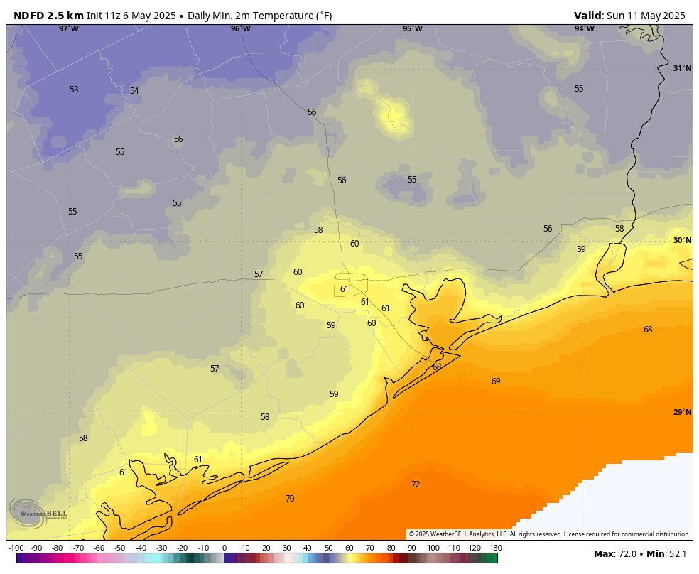
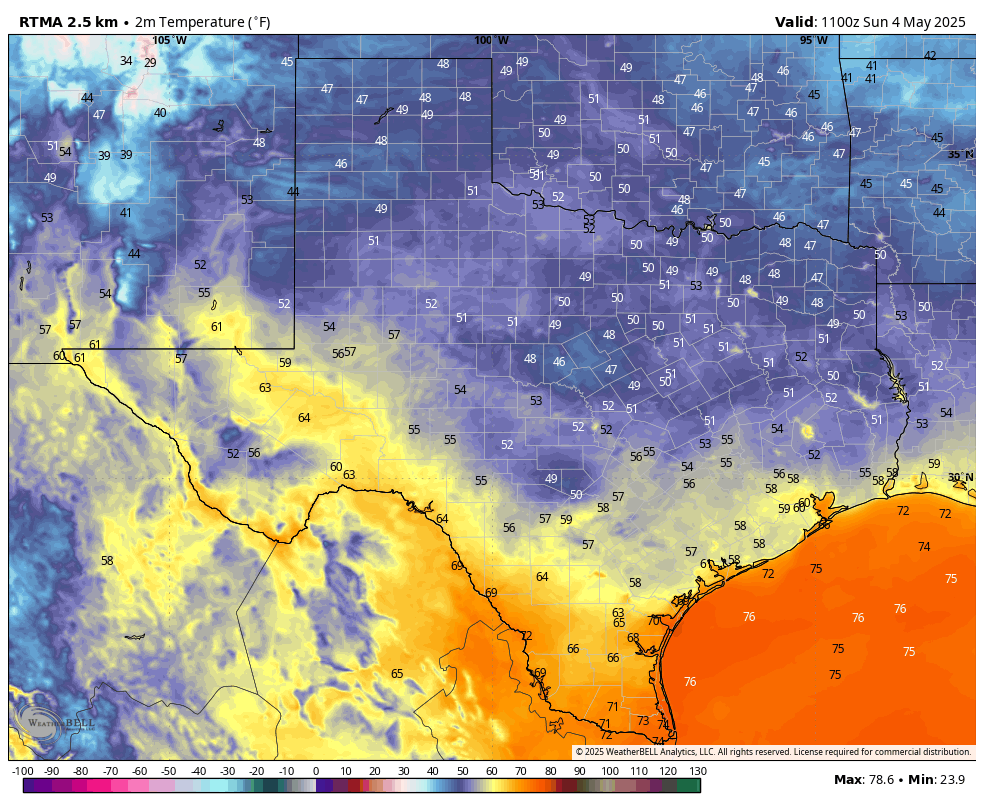
Low temperatures on Sunday morning in Houston. (Weather Bell)
Inland areas got into the 50s on Sunday morning in Houston, and most of the rest of the area enjoyed the lower 60s with drier air with dewpoints in the 40s. That’s really pleasant for May. I do think we’re going to see another weak front for next weekend, but unfortunately it’s unlikely to pull as much drier air with it. And first we’ve got to get through another stormy pattern.
Monday
Humidity is already on the rise this morning, and we’ll see southeasterly winds gusting up to 25 mph that will set the stage for more moisture in the air. We’ll start out with partly sunny skies this morning, but by some point this afternoon we should see mostly clouds. High temperatures will reach the vicinity of 80 degrees. By this afternoon and evening we will see some scattered showers, mainly located to the west of Interstate 45. A chance of light rain will spread into the entire region during the overnight hours as lows fall to around 70 degrees.
Severe weather outlook for Tuesday and Tuesday night. (NOAA)
Tuesday and Wednesday
The moisture that moved inland on Monday was a “warm” front, and it will set the stage for the possibility of heavy rainfall and storms on Tuesday and Wednesday in the Houston metro area. Our various high resolution models still have some discrepancies, but right now I would predict that the greatest potential for inclement weather will occur from late Tuesday morning through Wednesday morning across the region.
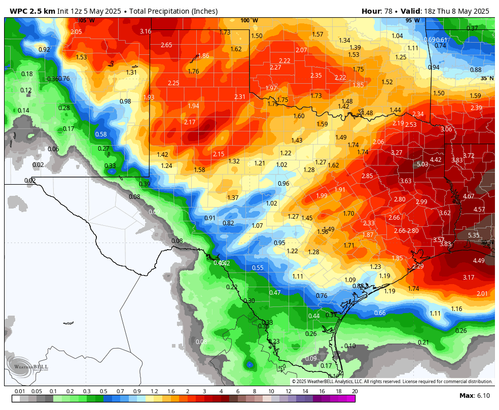
There will be the usual threats: damaging winds, hail, and possibly a tornado. We are also concerned about the potential for heavy rainfall. Most areas are likely to pick up 1 to 3 inches of rain through Wednesday, but we could see some higher bullseyes of 5 inches or more. For this reason we are going to institute a Stage 1 flood alert from Tuesday at noon through Wednesday. In terms of temperatures, Houston should reach the lower 80s on both days with plenty of humidity. We’ll have more on this later today and plenty of coverage the rest of the week.
NOAA rain accumulation forecast for now through Wednesday. (Weather Bell)
Thursday
Rain chances should diminish by Thursday, but will perhaps not go away entirely until the afternoon. Expect partly sunny skies and high temperatures in the low- to mid-80s. Lows on Thursday night should drop into the upper 60s.
Friday, Saturday, and Sunday
As a weak front drifts into the area we should see another nice weekend. I don’t know if we’re going to run it back and have things as nice as we just experienced, but as of now I anticipate mostly sunny skies with highs in the low 80s, overnight lows in the 60s, and modestly drier air. So if it is not cool as this past weekend, it will hopefully at least be somewhat pleasant.