Rain and cooler temperatures will persist into this weekend before full-on summer arrives

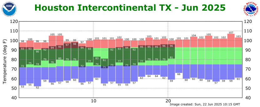
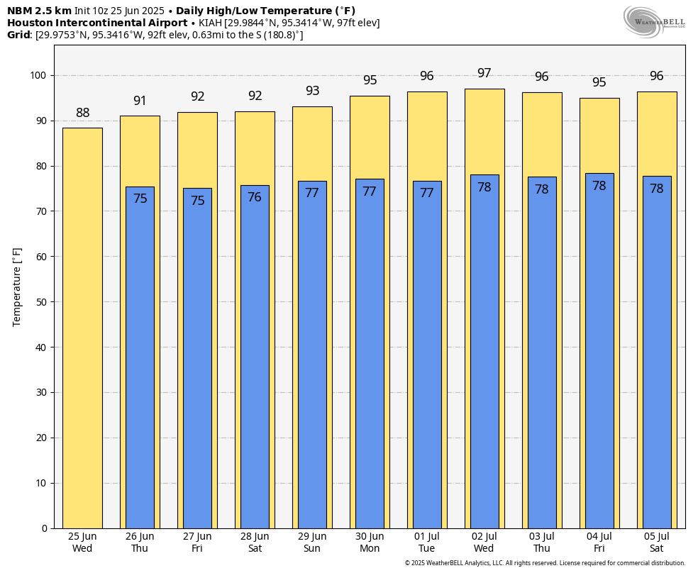
In brief: We continue to be in an environment where showers and thunderstorms are possible, and may be numerous during the daytime. This pattern will hold through today and possibly Thursday before slightly drier weather. Later, some time next week, temperatures appear likely to soar into the mid- or upper-90s.

Wednesday

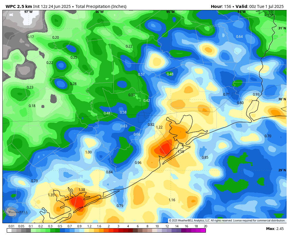
Showers and thunderstorms on Tuesday were definitely hit or miss: Some areas near Tomball and Sugar Land received in excess of 1 inch, while most of the rest of the region picked up significantly less. Then, last night, more than 1 inch fell in locations near League City. This pattern is likely to continue today, with hit or miss showers and thunderstorms across the region. Storms should be more common near the coast this morning before spreading inland later today.

As of shortly before 7 am showers are beginning to develop over coastal areas. (RadarScope)

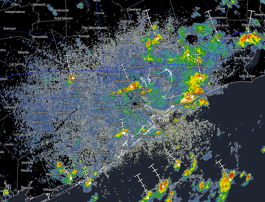
Overall rain chances are probably on the order of 60 percent with everything from gully washers to light rain to simply ominous skies in your neighborhood. Flooding shouldn’t be too much of an issue, but we cannot rule out some ponding on streets. Highs today will reach the upper 80s for most locations, but areas far inland will see a little more sunshine, and may push into the lower 90s. Winds will generally be light. Lows tonight will drop into the 70s, with decreasing rain chances.

Thursday

Expect a similar day to Wednesday, albeit with perhaps slightly less coverage of showers and thunderstorms. Nevertheless the potential for moderate to strong, if briefly lived, storms will be there. Temperatures and humidity will be similar to Wednesday.

Friday and Saturday

A slightly drier air mass should drop rain chances back to around one-in-three for each of these days, with decreasing intensity. As a result skies should be partly to mostly sunny, with highs in the lower 90s. For the most part, I think outdoor activities will be fine.

Sunday and Monday

These days should bring slightly better rain chances, perhaps 30 to 50 percent, but overall accumulations look modest. Expect highs in the lower 90s.

Downright hot weather is likely for much of next week. (Weather Bell)

The rest of next week

A modest ridge of high pressure may build over much of Texas later next week, and by Wednesday or so we should be solidly into the mid-90s, and possibly hotter toward the end of next week. So expect July to feel very July like. Whether this ridge sticks around or breaks down to allow some rain chances to return, well, we’ll just have to see. It’s not August—yet.

Houston faces a healthy chance of showers today and Wednesday, but nothing too serious

In brief: Showers and thunderstorms are likely across the greater Houston region today, starting near the coast and spreading inland, and Wednesday. We don’t expect them to be too disruptive. We should then dry out for a few days before another round of showers on Sunday or Monday.

Temperatures are fairly mild across Texas for late June. (Weather Bell)

Tuesday and Wednesday

The Houston region will experience slightly cooler weather, along with widespread showers and thunderstorms, during the next two days as the region’s atmosphere becomes unsettled. Although these showers will be most prominent during the daytime hours, some rain will also be possible during the overnight hours.

If you’ve lived in Houston for any period of time, you know generally what to expect. These storms will be hit or miss, with some areas seeing gusty winds and briefly heavy rainfall (and possibly small hail) whereas two neighborhoods over may only see dark skies. Most of these showers should be quick to move through, so we don’t expect widespread flooding issues. On average, most locations should pick up about 0.5 inch of rain over the next two days, but rain totals will vary widely.

Depending on the timing of rainfall at your locations, high temperatures are likely to range between the mid-80s and lower-90s. Skies will be partly sunny with generally light winds (outside of thunderstorms) at 5 to 10 mph. Nights remain warm and muggy.

Thursday, Friday, and Saturday

A slug of drier air moves in to the region during the second half of the week, and while this won’t entirely end rain chances, it should knock them down to about 30 percent each day. Consequently these three days should have mostly sunny skies and high temperatures in the lower 90s. If you have outdoor plans bring an umbrella, but I think showers each day will be more miss than hit. Overnight lows are in the upper 70s.

Sunday and Monday

Our model guidance indicates that another healthy chance of showers and thunderstorms will push into the area on Sunday and stick around through Monday. Overall accumulations may be on the order of another 0.5 inch for most locations, but I can’t really stress enough that totals will be inconsistent across the Houston region. On average I expect a bit higher rainfall amounts closer to the coast. Highs should be in the vicinity of 90 degrees.

NOAA rain accumulation forecast for now through Monday. (Weather Bell)

Next week

At some point next week I expect high pressure to more firmly establish itself. As a result we can expect rain chances to decrease significantly. I would also anticipate highs in the mid-90s next week by Tuesday or Wednesday, with a risk of upper-90s before the weekend. Hello, July!

A message from Eric, on behalf of Reliant

As you probably know, Reliant is a long-time partner of Space City Weather. As part of our relationship, I will occasionally share information about the products and services they offer. This is not a hard sell by any means, and I want to be sure these products are high quality. So, anything I write about here, I’ve tried. In this case, I’m excited to share that we’re in the process of installing Reliant’s new Smarter Home Bundle package, which is a free add-on for Reliant customers that makes home energy management smarter and our lives easier.

You never know who will pop up and say hello to your doorbell camera.

My family and I will be testing out the technology and features and sharing a review with you in the next month or so. But in the meantime, I wanted to share the basics for current and new Reliant customers. Qualifying customers receive a free Vivint Doorbell Camera Pro and Vivint Smart Thermostat paired with complimentary white-glove installation. In addition to these freebies, enrolling in this offer also gives you access to the Vivint app that provides personalized energy insights by Reliant and control of the Vivint devices in one spot. In other words, you should not need multiple apps to manage all the smart technology in your home.

I’ll report back soon on what the experience was really like for me. In the meantime, if you’re interested in learning more, click here.

Surviving Houston’s heat and houmidity, according to you

Last week Eric offered a tip for Houston-area newbies for surviving Houston’s fearsome heat and houmidity. (And no, that’s not a typo.) That inspired many of you to offer your own suggestions for dealing with summer. We’ve compiled the best of the best so you can work on your climatological coping skills.

As a native of SE Texas, summer is hot and that’s the fact, Jack! But…I have found that, if I talk or complain about the heat in June or July, that just seems to prolong the summer unnecessarily. Instead, I avoid those water cooler conversations about the heat…until August, then I let it all hang out! Because sometimes fronts start making their way into H-Town a few weeks into September, and it cools down to like 88 degrees and everyone starts thinking it’s fall and pulls out their sweaters! This strategy of denial means you only have a month in a half of hot weather…August and maybe half of September! All our our newly arrived neighbors thank me when I share this strategy with them!

– Sharron Cox

Even as the sun sets on the Memorial Park Eastern Glades, it’s still pretty toasty. (Dwight Silverman photo)

I don’t know if it truly helps any, but my psychological trick to get through the summers recently has been to count the weeks instead of the days. 9 weeks til September just on some psychological level feels better than 74 days. Maybe it’s because by this point, we’re typically mowing once a week, and I really don’t wanna by the time August comes around. And I know we’re getting close to only needing to do single digit cuts left.

– Josh Sorensen

Face the heat head on. Go outside for a walk at 3 PM. Go for a run in the morning and greet the rising sun. Lay in the grass at 2 PM. Feel the radiation. Sweat through the humidity. Learn to love that which we cannot change. This is the best way to deal with summer heat in Houston. Before you know it, you will think 90 degrees feels moderate. A slight breeze and you will have goose bumps. September starts to feel chilly.

– Humidity connoisseur

I am a native, and have lived in two other places, Los Angeles and Saudi Arabia. When I start to feel as though summer will never end (and honestly, it’s hot through sometimes mid November here) I remember how I felt when I stepped off the plane onto the tarmac in Dhahran, and the humidity slapped me in the face. It was 110F in the summer there with 80 to 90% humidity. I will never forget that. Houston is absolutely awful, but that was just a smidge worse (at the time – we’ll see how things change 🙁 )

– Ashley

I also try not to complain too much until August, go swimming at night to reset my body temperature, and my new summer hack is hanging out in the cheese aisle at HEB. Even colder than a movie theater and can grocery shop too.

– Cheryl Detten

August sunrise over downtown. It already looks hot, doesn’t it? (Dwight Silverman photo)

My Summer Survival Strategies:

1. Sit outside sometimes, to become acclimated, as another commenter said. The following two steps will help with this.

2. Cold iced Cafe du Monde made with tons of brown sugar and milk at 2 pm, outside. It’s the worst part of the day but you get to have coffee!

3. Wine and Chips O’Clock at 4 pm, outside. The worst part of the day’s heat is over! (I prefer white wine and potato chips.)

4. August 14: official Changing of the Morning Light Day. The sunlight in the morning changes from harsh blue-white to a softer yellow-white.

5. August 28 CHANGING OF THE LIGHT DAY!!! The light is noticably softer and golden. You have made it thru the worst. Only a month until the moveable feast that is COOL FRONT DAY!!!

Oh, and visit the gem and mineral section of the Science Museum. Like being in an ice cold glittery sparkly cave.

– Bea

One thing that gets me through the Houston summer is just knowing that for 8 months of the year between mid September and mid May the weather is actually quite decent and tolerable. Just gotta get through July and August and Fall will be right around the corner. 

– Anthony Stott

A trick I do is make it a point to get out for 20 or 30 minutes during the peak heat of the day. 3:00 – 4:00 p.m. I’ll get out and go for a motorcycle ride or do a little bit of work in the yard. Maybe just 15 minutes! lol. What this does is allows me to be absolutely scorched during that time and comparatively it makes the mornings and evenings feel much better.

– Scott Smith

Lived in Texas most of my life, especially the Houston area. Long enough to grasp the Biblical nature of this area: Dust to Dust, or Noah’s Ark.

– Shawn Harrison

If these pearls of heat-related wisdom inspire you to offer tips of your own, please do so in the comments!

After a relatively mild June, what does the rest of summer hold for Houston?

In brief: With high pressure backing off for a few days, rain chances will be higher during the first half of this week. We also take a look at what is likely to come, weatherwise, for the remainder of summer in Houston.

Past is prelude?

As we often say here on Space City Weather, there are many definitions of summer. From a strictly meteorological standpoint, summer comprises the months of June, July, and August. In practicality, September is almost invariably a summer-like month in Houston as well, at least the first two or three weeks. So today we are going to take a look at what the region can expect during the next three months—effectively the rest of summer.

First, let’s look back at what has come so far. June, to date, has not felt super hot. However this has been masked by a relatively cool spell during the middle of the month when the city received widespread rains. There was about a week when the high temperature ranged from the 80s to lower 90s. At the same time, the city has also had more than a week of highs that reached 95 degrees, or higher. This is above the “normal” high for Houston, in June, 92 degrees. So when you add it all up, the average temperature this month is running about 2 degrees Fahrenheit above normal.

Looking ahead to July, August, and September, I rather think this is what we are most likely to see for the remainder of summer. Houston will probably see warmer than normal temperatures, but nothing too extreme. In other words, July and August are likely to bring plenty of days in the mid-90s, but perhaps only a sprinkling of days in triple digits. In terms of rainfall, the various seasonal models indicate near-normal precipitation for the remainder of summer. Hopefully this rain is fairly evenly distributed, rather than the result of one or two tropical systems. But of course that is something we cannot predict at this time.

Seasonal temperature outlook for July, August, and September. (NOAA)

Speaking of the heat, our partner Reliant offers a “Beat the Heat” program during the summer months to provide more than a dozen cooling centers across the Houston region. You can find a list of locations here. There is also a payment assistance program for people struggling to pay their electricity bills during the summer.

Finally, I want you to be on the lookout for a post later this morning, at 10 am. Last week I shared a tip on how I survive the summer, psychologically. You responded with some great suggestions of your own, and Dwight Silverman has collected them in a post. It’s great fun and I admire your creativity.

Monday

As we saw on Sunday, Houston’s atmosphere is a little more open to rainfall with high pressure having departed the region. That pattern will continue today, with rain chances of perhaps about 30 percent. To go along with this we will see partly to mostly sunny skies and high temperatures in the low- to mid-90s. Afternoon winds will peak at about 10 mph from the southeast, with higher gusts. Lows tonight will drop into the upper 70s.

Tuesday and Wednesday

The middle of the week should have the best rain chances, with probably at least half the area receiving rainfall each day. These will be the kinds of storms where some parts of Houston quickly pick up 1 or possibly 2 inches of rainfall, and many other areas see on the order of a tenth of an inch, or two. In other words, they will be hit or miss, and it’s not really possible to forecast right now where the heaviest rains will be. Highs both days will likely be in the lower 90s, with partly sunny skies.

NOAA rain accumulation forecast for now through Saturday morning. (Weather Bell)

Thursday and Friday

Rain chances will drop back to about 30 percent, daily, to end the work week as our atmosphere becomes a little bit more stable. As a result expect mostly sunny skies and warmer temperatures, with highs in the low- to mid-90s. Nights remain warm and humid, of course.

Saturday, Sunday, and beyond

Saturday’s weather probably will be a continuation of what we experience on Thursday and Friday, but by Sunday rain chances may be on the upswing again. At this point my expectations for Sunday into next week are ongoing daily rain chances in the vicinity of 30 to 50 percent each day, with highs in the lower-to-mid 90s. In other words, this pattern of fairly typical late June weather may well continue into early July.