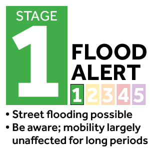
In brief: We interrupt your Labor Day weekend just to reinforce our messaging that widespread rainfall is likely today and Monday, and there is a risk of excessive rainfall particularly on Sunday. We are calling for a Stage 1 flood alert on our scale out of an abundance of caution.
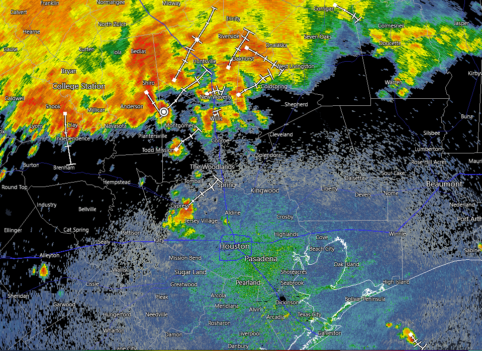
A snapshot of Houston’s radar as of 10:51 am CT on Sunday. (RadarScope)
If we check the radar as of late morning on Sunday there is a large mass of showers and thunderstorms to the north of the Houston metro area, pretty much along and north of Highway 105, which runs through Conroe. These storms are slowly moving south and will have some impact on the Houston region today, although we still have some questions about how much.
The background factors are a slow-moving, or essentially stalled front that should sag down into the Houston region today. The atmosphere is already laden with moisture, and the front will provide a spark to generate precipitation. For these reasons we face the potential for heavy rainfall in our region today, and we are instituting a Stage 1 flood alert through Monday. This means there should be mostly minor flooding impacts, with the potential for frontage roads and low-lying streets to back up. Not everyone will see rain, and fewer still heavy rainfall.
My general sense is that the mass of storms to our north should mostly remain to the north. But there is certainly a risk of re-development over central or coastal parts of the region later today. The environment for Monday also should be favorable for additional showers and thunderstorms, although the potential for flooding appears to be slightly less. The bottom line is that, as you enjoy the Labor Day holiday weekend in Houston, please be weather aware, and keep an eye on the radar as you venture out and about.
In brief: In today’s post we take a look back at Hurricane Katrina, and what has changed in the 20 years since then. Additionally we discuss a front that will slog into the area and make for a soggy weekend. However, we do expect drier and cooler weather for much of next week, which is a fine way to start September.
Katrina at 20 years
As many as a quarter of a million people evacuated from New Orleans to Houston before and after Hurricane Katrina struck the city 20 years ago, today. My hope is that, if you’re from Louisiana and reading this site, that you have found a good home in the greater Houston area. One thing I love about this city is that we are generally a welcoming people, with a warm culture that rewards hard work. Hurricanes are awful disasters, tearing apart not just physical structures but communities and human bonds. In that sense Katrina is the most wrenching storm of our lifetimes, utterly transforming New Orleans and upending so many lives.
Satellite image of Hurricane Katrina one day before landfall in 2005. (NOAA)
Katrina marked a defining moment in my career. By 2005 I had been writing about science for the Houston Chronicle for half a decade, and had very recently begun a science blog for the newspaper called “SciGuy.” (The Chronicle has taken it offline, but you can find it on the wayback machine). As I had written about the “big one” hitting southern Louisiana before, I decided to go all-in on covering the storm online. It was my first real experience writing about weather, forecast models, and meteorology in real time. Three weeks later I went even deeper when Hurricane Rita threatened Houston and prompted a horrendous evacuation. That experience helped me realize that it was possible to compete with television stations online in weather forecasting. It was the beginning of a journey that led to me getting an education in meteorology, becoming a meteorologist, and starting Space City Weather 10 years later. And here we are.
Finally, I worry a lot about what would happen if a storm like Katrina threatened the Gulf coast again. It surely will. Certainly our ability to predict where a storm will go, and how strong it will get, has improved dramatically in 20 years. But beyond that, as a society, I fear we are in a worse position. The public’s trust in the federal government has been shaken. For example, in the wake of Hurricane Helene last year FEMA workers were harassed. In terms of a media environment, no one trusts anyone, and misinformation about weather is rampant online. Heck, we cannot even agree on what to call the Gulf any more. Hurricanes rip at the fabric of our societies and governments, and that fabric is weaker than it was two decades ago; our communities and institutions more riven by politics and mistrust. I have spent some time over the last week reading government reports from 20 years ago in the wake of Katrina that assessed failures (i.e. this bipartisan report from Congress), and it is painfully obvious we have not heeded many of the lessons that Katrina taught us. We are bound to learn them again with future storms.
Friday
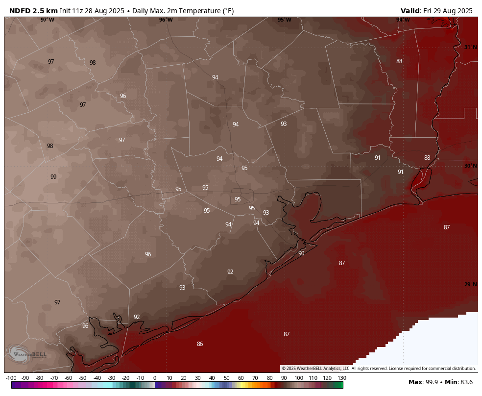
We are still watching for the possibility showers and thunderstorms later today, which could impact Friday Night Lights and the beginning of high school football. Overall chances are pretty low, perhaps in the range of 20 percent. But the atmosphere is perturbed enough that anything that gets going could develop into something with a fair bit of lightning this afternoon or evening. Otherwise we can expect a hot and mostly sunny day, with high temperatures in the mid-90s for most locations away from the coast. Clouds will increase tonight, with lows dropping into the upper 70s.
Saturday
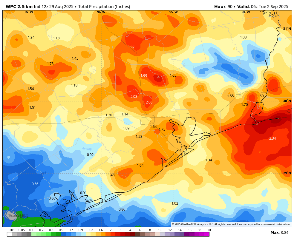
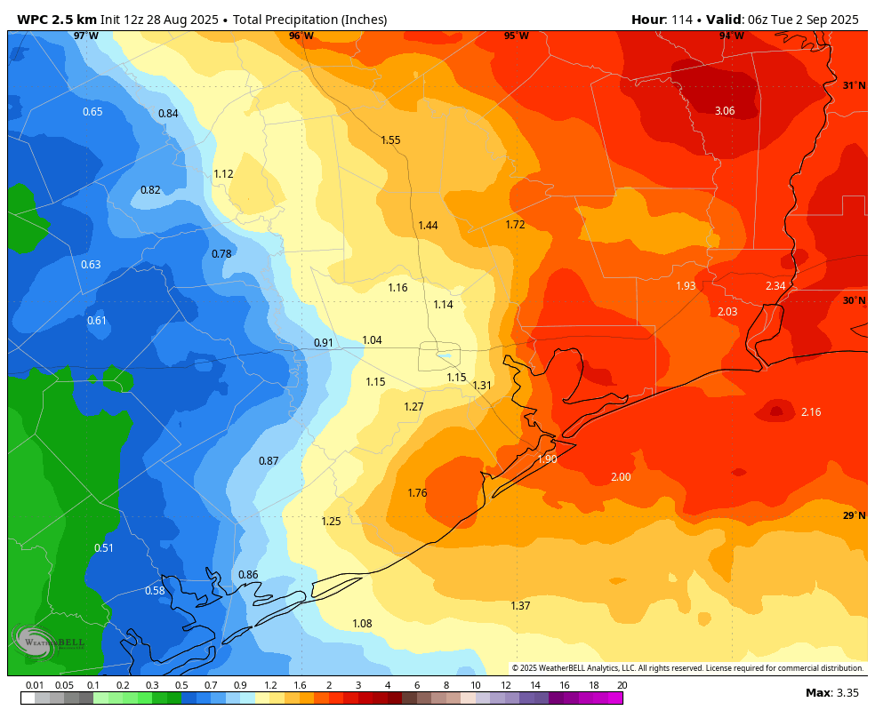
A cool front will approach and move into the city on Saturday. Once again I want to be clear about expectations. We are not at the point of the the year when fronts come barreling into the region and one can step outside and say, “ahh, that’s refreshing.” Maybe October for that. So this front will move in and then dry air should slowly accumulate over the next few days. Alright, so Saturday is still going to be pretty warm (low 90s) and humid. We are also going to see a healthy chance of rain, about 50 percent, that will continue for much of the Labor Day weekend. It won’t be wall to wall rain for sure, but there should be rounds of showers that add up to 1 to 2 inches over the weekend, with isolated areas getting more. Lows on Saturday night will probably remain stubbornly in the upper 70s.
NOAA rain accumulation forecast for now through Labor Day. (Weather Bell)
Sunday and Monday
I think rain chances will probably peak on Sunday before falling back a bit to about 50 percent on Labor Day. This will help moderate high temperatures, keeping them at about 90 degrees, with nights in the mid-70s. The bottom line is that yes, you probably will be able to find some sunny spots of weather this weekend, but you’re also going to need to be dodging showers that could bring some spurts of moderate to heavy rainfall. Matt and I will be watching things this weekend, and if an update is warranted regarding the potential for flooding, we’ll have something for you. But for the most part we expect these to be nuisance showers rather than something that is seriously impactful to mobility.
Next week
Rain chances should drop significantly by Tuesday. We generally should remain in a pattern where there’s a northerly flow next week, and possibly into next weekend. This means, I think, that we will see mostly sunny days with highs in the low 90s, and nights in the low 70s. Eventually (by Monday or so) we probably will start to feel some drier air that does knock down humidity a bit.
Finally, I don’t want to give anyone false hope, but the European model has been hinting at the possibility of a slightly stronger front by Friday-ish of next week for a couple of days now. I’m not certain that will happen, but it does seem possible. We shall see.
In brief: The next two days will feel pretty typical for Houston’s hottest and most humid month, but a front will usher in a pattern change for Labor Day Weekend. We will see higher rain chances on Saturday and Sunday, before some modestly drier air arrives. High temperatures for parts of the holiday weekend may top out in the 80s.
Thursday
After fairly widespread shower activity on Wednesday the region should only see isolated rains today, with the best chances (perhaps 30 percent) right along the coast. Skies will be mostly sunny, with sticky humidity. Winds will blow from the south at 5 to 10 mph. In terms of temperatures, generally we can expect highs in the low- to mid-90s, which is pretty standard for this time of year. Lows tonight will be sticky, dropping only into the upper 70s.
Friday should be the hottest day of the upcoming forecast period. (Weather Bell)
Friday
Friday should be another mostly sunny day, with high temperatures pushing into the mid-90s for the most part. So, pretty warm. However, unlike on Thursday there should be a slightly better chance of showers and a few thunderstorms developing during the afternoon and evening hours. This is because the atmosphere should become a little more unsettled as a front slowly advances from the north, and this has the potential to impact some High School football games. There’s also a scenario in which the storms hold off until later on Friday night after the lights are turned off. We shall see.
Saturday
This is the day when a front slowly sags into the region. It will take some time for (modestly) drier air to work its way into Houston, so Saturday is still going to feel fairly warm and humid, with highs in the lower 90s. Showers and thunderstorms will become increasingly likely during the afternoon hours, with the best chances northeast of a line from Kingwood to Baytown. Rains remain likely on Saturday night and into Sunday, with lows dropping into the mid-70s.
NOAA rain accumulation forecast for now through Labor Day Weekend. (Weather Bell)
Sunday
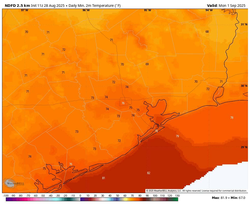
Skies look to remain partly to mostly cloudy, and along with ongoing rain chances (perhaps about 50 percent) for the area this should combine to limit high temperatures to the mid- to upper-80s. Our air will be slightly drier, but you should not expect to walk outside and say, “oh my, it’s fall!” Lows on Sunday night could drop into the lower 70s for areas inland of Interstate 10, but I’m still not sure just how much drier and cooler air will arrive this weekend.
Forecast low temperatures on Labor Day morning in Houston. (Weather Bell)
Labor Day
The holiday looks to be a partly sunny day. High temperatures should top out in the upper 80s to about 90 degrees, with a low-end chance of rain. Lows on Monday night should again drop into the lower 70s for areas away from the coast.
Next week
As rain chances back off, high temperatures may try to rally into the mid-90s for a couple of days with mostly sunny skies. There are some hints of another front by next weekend, but there is no real consistency in the models and I don’t want to set expectations. Pretty clearly, however, we are not headed toward a sizzling early September, like we sometimes see.
In brief: As part of our long-time partnership with Reliant, we will (very) occasionally share information about products and offerings from the company. Today, Eric writes about his experiences with a Smarter Home Bundle offered by Reliant and Vivint.
There are a lot of “smart” things available these days that I just don’t get. Like, for example, a “smart” toaster. Who needs an app to know when their bagel is toasted? Or a refrigerator with a giant screen on it to remind me to buy milk. No thank you. I used to have similar reservations about a “smart” home, but no longer. I’m now among the converted.
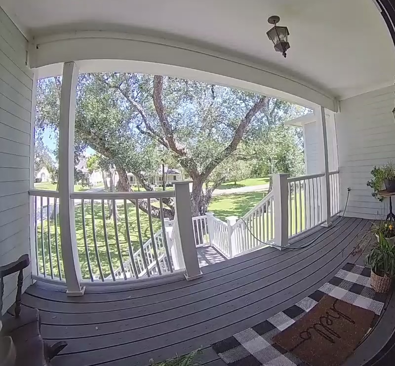
Hello from my new door bell camera.
That’s because, earlier this summer, I had the “Smarter Home Bundle” installed at my house. What is that, you may ask? It’s essentially a new offer for Reliant electricity customers to make home energy management easier. It pairs a Vivint doorbell camera, smart thermostat, and professional installation together with your electricity plan. It’s completely free for qualifying new and current Reliant customers. You can also add on a lot of goodies like Vivint’s Smart Hub control panel, 24/7 professional security monitoring, additional external or indoor cameras, smoke and carbon monoxide detectors, remote operation of garage doors, keyless entry, and more. The beauty of this is that it is all packaged within a single system, and a single app.
At the office but want to see who delivered a package this morning? No problem, the video is there.
Sitting in the bathtub but want to turn down the air conditioner. Easily done.
Want to open the garage door so a neighbor can borrow a shovel? All good.
Is it raining heavily and you need to see if flood waters are rising in the back yard? Sure. (But let’s hope I don’t ever have to do that.)
Speaking of the app, a unique feature about this bundle is the energy insights. Through the Vivint app, you can control your new smart thermostat and sync it with your Reliant electricity account to help you better manage your energy, see your projected costs and understand the drivers of your electricity use. Of course, here in Houston, that will be our air conditioners in the summer, but it’s useful to see your personalized usage and what else is using energy in your home.
The complimentary installation as part of the Smarter Home Bundle is a huge plus. The install process for me went smoothly, but if you plan on adding any tech beyond the doorbell camera and smart thermostat, I recommend letting Vivint know before someone comes out. That ensures that the technician has the necessary equipment on hand for your home.
What I like about the security system via the doorbell is that it all just works. It really is “smart.” And it’s very customizable, so if you want to play a deterrent sound when someone approaches the front door, you can. Or, if you opt to add a smart door lock like I did, you can have “deter” off and remotely unlock the door for a friend. The app is just really intuitive that way, and it is far better than any other home alarm system I’ve worked with.
Another ‘exciting’ day at casa Berger.
I’ve had my system for a couple of months now and wanted to take my time to live with the equipment, the app, and the experience before providing a review for you. And honestly, it’s been great. If you’re looking for a smarter home that’s easier to operate, this is the way.
To sign up or learn more about the offer or products, you can visit Reliant.com/smarterhomebundle or speak with our friends at Reliant at 1-866-222-7100.
A note from Reliant
We want to assure you that customers are always in control of their smart thermostat. You can adjust your temperature settings at any time, either right on the device or through the Vivint app. Our goal with the Smarter Home Bundle by Vivint and Reliant is to give you more options and flexibility to manage your home’s energy use and stay comfortable.