Tolerable, not terrible August weather continues for Houston

In brief: Another round or two of showers and storms will pelt many parts of the Houston area today, with some locally heavy rain possible. Rain chances will start to slow this weekend into early next week before the next round of rain chances kicks off around midweek. There are no current tropical concerns for the Houston area.

Yesterday’s storms were relatively squirrely, especially down in Brazoria and southern Fort Bend Counties. There was a 66 mph wind gust reported from a CenterPoint weather sensor at Brazos Bend State Park. Fascinatingly enough, the radar looked rather innocuous with the storm at the time, but some strong wind gusts elsewhere, including nearly 50 mph just west of Damon seem to back that reading up. That’s just the thing with storms this time of year in Houston: If you catch one at the wrong point in its life cycle in the wrong way, it can produce some pretty quick, short-lived but nasty impacts.

Today

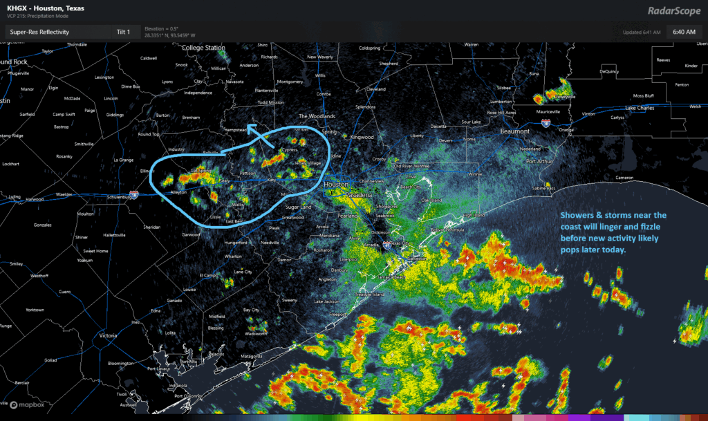
Already today we’ve seen plenty of thunder and some wind gusts up near 50 mph near San Luis Pass. As of this writing, the heavier storms are all offshore, with some isolated downpours and lightning outside the Beltway in western Harris County back through Sealy and Columbus.

(RadarScope)

As the day goes on, we may actually see things calm down a bit for a time before ramping back up again this afternoon or this evening. I’m not entirely confident on the timing of the next wave; some modeling is quick and quite aggressive with coverage of the next wave of showers as early as late morning. Others hang development back until late afternoon. But we do know a second wave of scattered downpours is likely later today. Expect a very sporadic pattern of coverage with some places seeing squat and others seeing as much as 2 to 3 inches in short order.

Weekend

A continued chance of showers and thunderstorms will be with us on both Saturday and Sunday, as is typical for August. We do think coverage and some of the intensity of the storms will wane a bit on both weekend days, with perhaps Sunday having even less coverage than Saturday. We may see another rude early wake up in spots on Saturday morning as some nocturnal storms could pop up after midnight between Houston and the coast. Then I think we’ll see a summer pattern of mid to late afternoon isolated to scattered downpours resume.

Look for highs in the mid-90s, with a few isolated upper-90s possible.

Monday and Tuesday

We think things will be similarly subdued like Sunday to start next week. Rain chances certainly are not zero, but they’ll remain lower. Highs should again be in the mid-90s.

Midweek next week

We should see another boundary drop in or develop over the region around midweek next week. This should mean an increase in shower and thunderstorm coverage once again. Look for cooler daytime highs as a result.

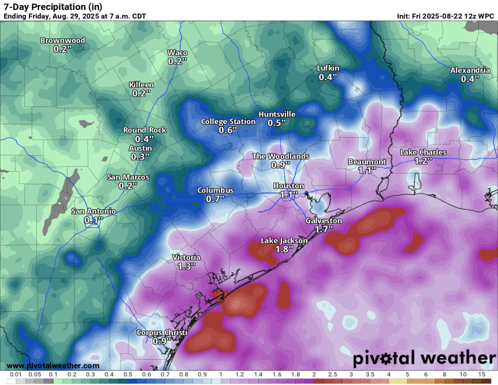
Rain forecast through next Thursday. (Pivotal Weather)

Total rainfall between today and next week is likely going to be around 1 to 3 inches near the coast, with lesser amounts inland. Isolated higher amounts are possible anywhere in the area, and yes, some isolated places will see lower amounts too.

Tropics

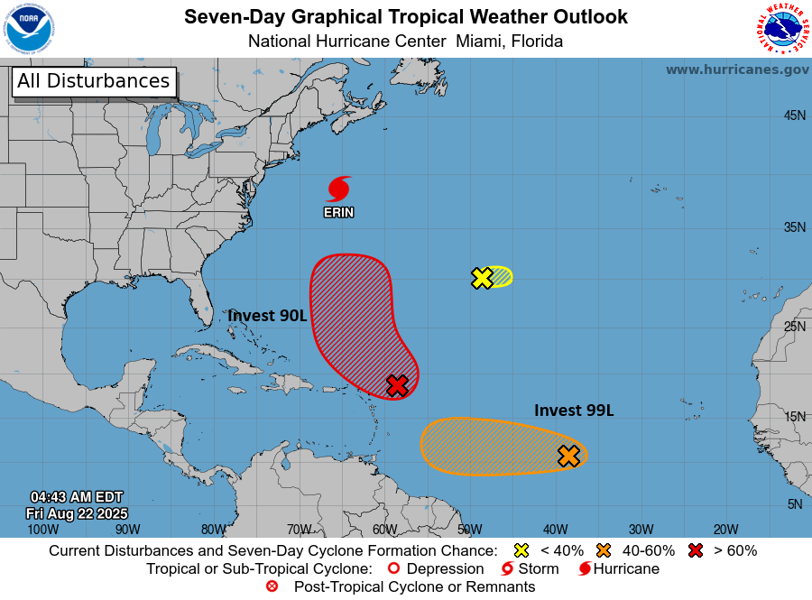
The map currently favors us for the most part.

(NOAA/NHC)

Of the activity out there today that we’re monitoring, only Invest 99L is worth keeping an eye on. No reliable model guidance is bringing it to the Gulf, but just out of respect for the calendar and history, it’s important to just check in and see if southern tracking waves like this one heading for the Caribbean can survive enough to get closer. Even if it were to do that, I’m not sure that the upper pattern would allow it to come north much, if at all. So either way, this probably ends up buried in Central America ultimately. But we’ll babysit it anyway. Other than that, you can continue to assume the brace position as we navigate the final 5 to 6 weeks of our peak hurricane season. We’re all just trying to get to the finish line.

Healthy shower chances today and Friday, and August should end in about the best way possible for Houston

In brief: Today’s post discusses the favorable setup for rain on Thursday and Friday in the greater Houston area, with the best conditions closer to the coast. Rains should diminish some this weekend, with Sunday looking especially sunny. Overall our temperatures look moderate for the rest of August.

A favorable setup for rain

There’s a lot of support for showers and thunderstorms to develop in our region today and Friday, with better coverage especially during the afternoon and evening hours. The atmosphere is laden with moisture, we have a nearly stationary boundary (essentially a dying front), the sea breeze, and plenty of daytime heating. In such an environment we are likely to see widespread showers, and within that some stronger and possibly severe thunderstorms.

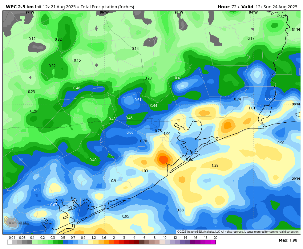
The most likely time for activity is from mid-afternoon through the early evening hours, and the most favorable conditions will be closer to the coast (essentially, south of Interstate 10). Rain amounts will be widely variable, with some areas picking up a quarter of an inch, and other areas possibly 3 or more inches through Saturday. As a result we will probably see some ponding on roadways, and perhaps a few isolated flooding issues. Although we don’t anticipate major disruptions from these rains, you’ll want to check the radar before heading out. Slightly higher pressures should begin to limit shower coverage by Saturday.

NOAA rain accumulation forecast for now through Saturday. (Weather Bell)

Thursday

Overall rain chances are about 60 percent today in the region, although I’d go higher than that closer to the coast, and less for inland areas. We will see partly sunny skies, with light north or northeast winds. High temperatures for most locations will be in the mid-90s, but temperatures will quickly drop into the 80s, or possibly even upper 70s, within showers and thunderstorms. Humidity will remain high. Lows tonight drop into the upper 70s with an ongoing (albeit lower) chance of showers.

Friday

This is probably the day when most people will see the most rain, so again prepare for the possibility of some brief disruptions. With increased cloud cover, expect high temperatures in the vicinity of 90 degrees. Winds will be light. Lows on Friday night will drop into the upper 70s for most locations.

Saturday and Sunday

The first half of the weekend will see some lingering clouds and showers. Highs on Saturday, accordingly, should reach the lower 90s for most locations. But we should definitely be on a downward trend in terms of amounts, as high pressure begins to build to the west of the region. Sunday should be mostly sunny, with rain chances only in the vicinity of 20 percent. Expect highs in the mid-90s. So for beach and pool activities, Sunday is the pick of the litter.

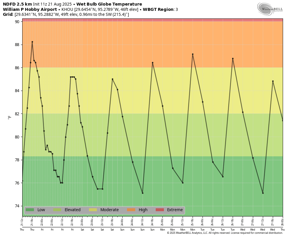
These are pretty reasonable “wet bulb globe temperatures” for Houston in late August. (Weather Bell)

Next week

To start next week we will remain in a pattern of mostly sunny weather, with highs in the low- to mid-90s and lower end rain chances. However by Wednesday or so we may start to feel the impacts of another decaying front. This probably will bring some increased rain chances, although to what extent it’s difficult to say. High temperatures also may hold somewhere in the vicinity of 90 degrees for much of Houston, which is a pretty great way to end August in these parts.

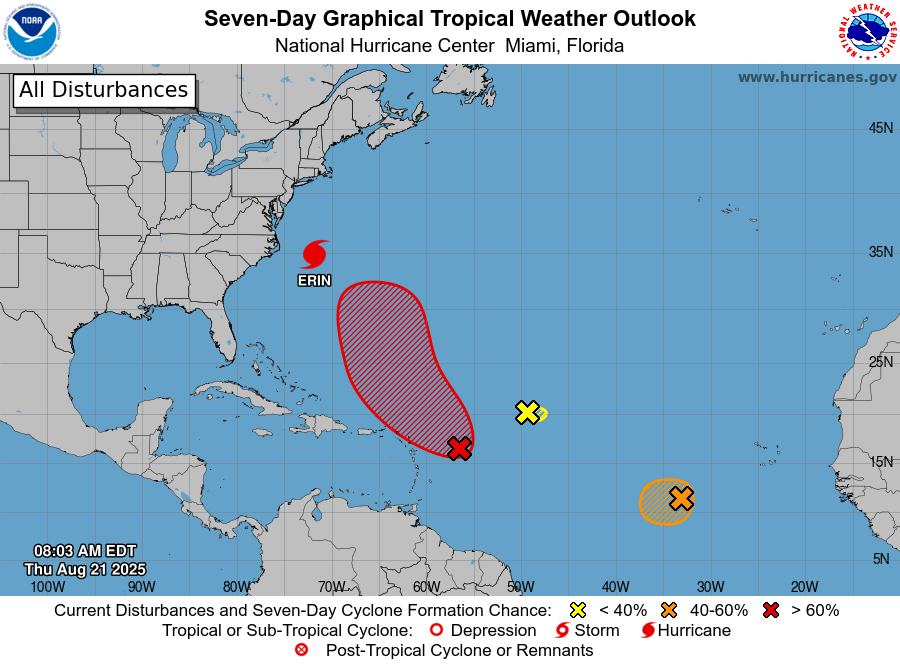
There’s plenty to look at in the tropics, but nothing that is imminently bound for the Gulf. (National Hurricane Center)

The Atlantic tropics

Hurricane Erin is passing almost directly between Bermuda and the Outer Banks this morning, remaining far enough offshore to avoid bringing catastrophic damage to both locations. After some intensification on Tuesday, it is also beginning to weaken. There are other storms that may form in the coming days, but I’m happy to report that we see no imminent threats to the Gulf at all. Again, this is a pretty great place to be, tropics-wise, as we get toward the end of August.

A weak ‘front’ will bring unsettled weather to end the week, but the weekend outlook improves

In brief: We may see an additional round of storms this afternoon as a disturbance drops into the area, and then fairly widespread showers are likely on Thursday and Friday. The outlook for the weekend is sunnier, with lower rain chances.

A few more words about August

I wanted to share some feedback I received after yesterday’s comments about August weather in Houston. (If you don’t remember, I basically said there is nothing redeeming about August’s weather here). This person wrote in to say:

“I really like the in-depth forecasts, but the continued complaining about Houston’s hot & humid climate does not serve you well …   If you moved here from a colder climate, and you don’t like the heat here, why torture yourself?  Move back and enjoy your life.  But if you’re going to call yourself a Texan, a Houstonian, or just live here, please consider dropping the complaints.  It’s one reason I don’t frequent your site more.”

First of all, thank you for the feedback. We are always looking to improve the site and be more responsive to reader needs. However, I will be ignoring this suggestion. Yes, I realize that there are some people who like peak summer weather in Houston. Bless your hearts. However I do call myself a Houstonian (having lived here for 28 years), and one of the defining things about being a Houstonian is the God-given right to complain about the summer weather here. If that turns you off, I’ll just have to live with that.

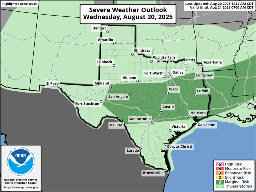
Severe weather outlook for Wednesday. (NOAA)

Wednesday

Today is an interesting one. We should see sunny skies and hot and humid weather, withs high pushing into the upper 90s this afternoon for all but inland areas. However, an upper level disturbance should drop down from north of the region later this afternoon and push into the city. I’ll be frank, the modeling has not been consistent with this. However, given what we have seen in recent days, and the abundant moisture in the atmosphere, I feel confident in predicting that some parts of the metro area will see rain this afternoon or early evening, and that some of these showers will turn into thunderstorms (possibly severe). So be on the lookout for storms later today, but they may very well not hit. Overall rain chances are probably only about 40 percent. Lows tonight will only drop to around 80 degrees.

Thursday and Friday

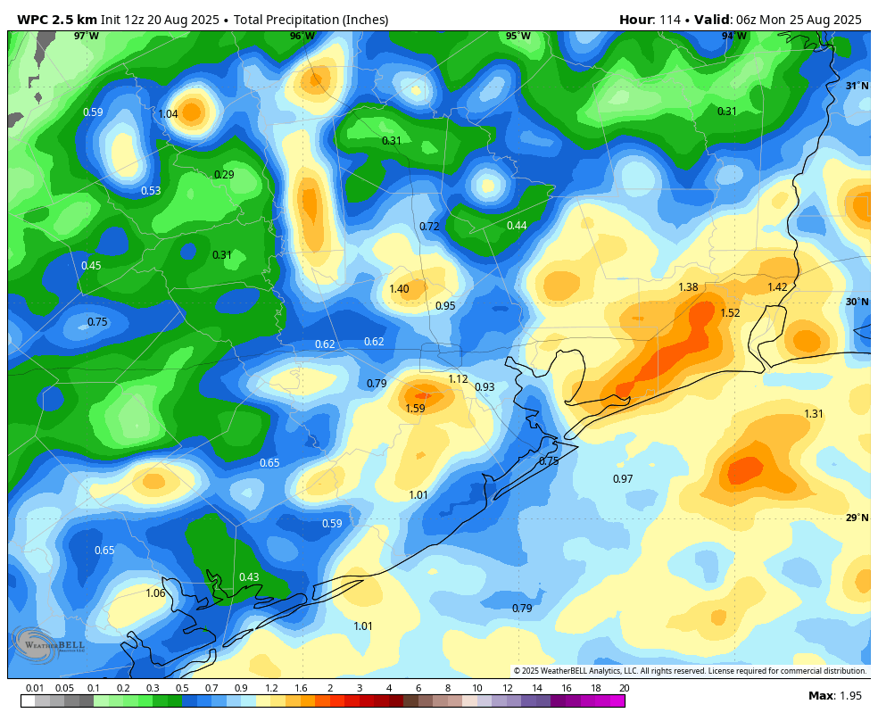
A frontal boundary will ooze into the area to end the work week, and while this won’t provide much in the way of dry air or cooler temperatures, it should be the spark for some fairly widespread showers and thunderstorms. Rain totals will, as is often the case, be highly variable across the region. I expect most of us to receive 0.5 to 1.5 inch, with higher bullseyes perhaps a little more likely south and east of the city. In any case, you should be prepared for downpours to interrupt outdoor activities, but it won’t rain all of the time. Highs should be a little lower, in the low- to mid-90s, with warm, humid nights.

NOAA rain accumulation forecast for now through Sunday. (Weather Bell)

Saturday and Sunday

As high pressure expands from our west this weekend it should slightly dry out the atmosphere and reduce daily rain chances to about 30 percent. These days should, accordingly, be mostly sunny with high temperatures probably in the vicinity of the mid-90s.

Next week

Next week is the final full week of August. Fortunately we look to be ending the month with (for Houston) relatively modest conditions, with highs in the low to mid-90s, and daily rain chances of maybe 20 to 40 percent. Another dying front will approach the area later in the week, but I’m not sure it will have that much sensible impact on our weather. We’ll see.

Daily storm chances continue as August plods onward

In brief: Today’s post rants a little bit about August weather in Houston, and proceeds to talk about a weak (emphasis on weak, y’all) front moving into the region. This is mostly just going to drive increased rain chances on Thursday and Friday as we stay uncomfortably in the 90s, temperature-wise.

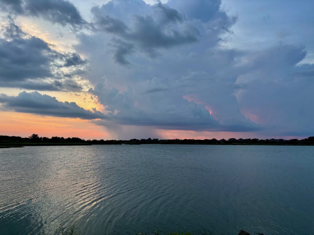
Showers on Monday were hit or miss, as this photo taken near sunset indicates. (Eric Berger)

August rant

There is never any good weather in August in Houston. As I’ve written before, it’s either blazing hot with a burgeoning drought, or some tropical system is bearing down on the region. This month has been, shall we say, not terrible as daytime temperatures have been a little more reasonable and there has been some on-and-off again rain showers to help with our soils. (Although yes, angry person on Facebook, not everyone has gotten rainfall every day).

As expected, some scattered thunderstorms developed on Monday afternoon and evening, and indeed we anticipated that some of these would bring (briefly) heavy rainfall and strong winds. However I did not expect serious hail, but this being August of course that’s what happened. In areas such as Champion Forest and Jersey Village there was half-dollar and golf ball-sized hail reported. We cannot rule this happening again, elsewhere, for the rest of the week.

The point I’m trying to make is that there really is no helping August weather in Houston. The only thing one can do is survive and advance. The good news is that we’re doing that. Today is August 19, and there are just 12 days and 20 hours until September 1.

Tuesday

The pattern today should be a little bit different, with shower and thunderstorm developing a little bit earlier in the day. It will be driven more by a weak disturbance moving through than the sea breeze, and accordingly showers will be most likely from mid-morning through the early afternoon hours. Storms have already initiated north of the area, in Conroe, and I expect these to drop down into the city and coastal areas over the next few hours. Highs will generally be in the mid- to upper-90s for much of the region, especially with the likelihood of clearing skies this afternoon. Lows tonight will only drop to about 80 degrees.

Wednesday

This will be a hot day, and I suspect we’ll be back to showers and thunderstorms later in the day, during the afternoon and early evening. You know the drill, rains will be hit or miss. Look for highs generally in the upper 90s away from the coast.

Thursday and Friday

I’ve been hesitating to call it a “front,” because people have reasonable expectations for a cold front moving into Houston. However, meteorologically speaking, a front will push into the area on Wednesday and Thursday. Alas we’re not going to see some grand influx of drier air and cooler temperatures. A front at this time of year mostly just perturbs the atmosphere, so we’ll see increased rain chances (perhaps 70 percent daily) to end the work week. We can expect daily highs in the low- to mid-90s, with nighttime temperatures in the upper 70s.

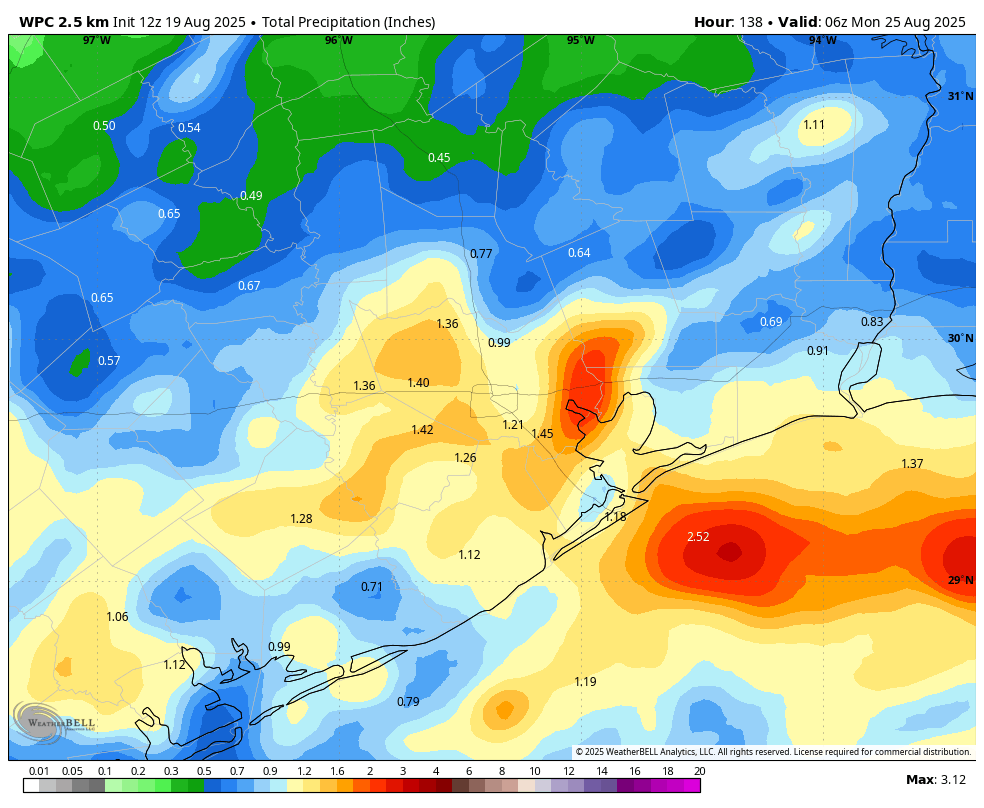
NOAA rain accumulation forecast for now through the weekend. (Weather Bell)

Saturday and Sunday

The front should stall around the coast, so we are likely to see an unsettled pattern persist into the weekend. Expect highs in the low- to mid-90s, with high rain chances on Saturday, and perhaps lesser coverage by Sunday. I would not characterize the weekend as a total washout, but there definitely will be the chance of showers and thunderstorms, especially on Saturday. Overall accumulations for most locations through the weekend will probably be on the order of 1 inch. However, there probably will be a few bullseyes that accumulate 3 to 4 inches of rain over the next few days, and this may lead to some spotty street flooding.

Next week

Overall next week should bring lower rain chances and partly to mostly sunny days as we transition back to a more typical late August-like period. My expectation is for highs in the mid-90s, but we’ll see what happens.