Taking stock of the Atlantic hurricane season as we enter crunch time

In brief: In today’s post we discuss our increasing rain chances for this week, with a wet period most likely from Thursday through Saturday. We also dig deep into an outlook for the rest of the Atlantic hurricane season as we have now entered “go” time for the season and Texas.

“Go” time for the tropics

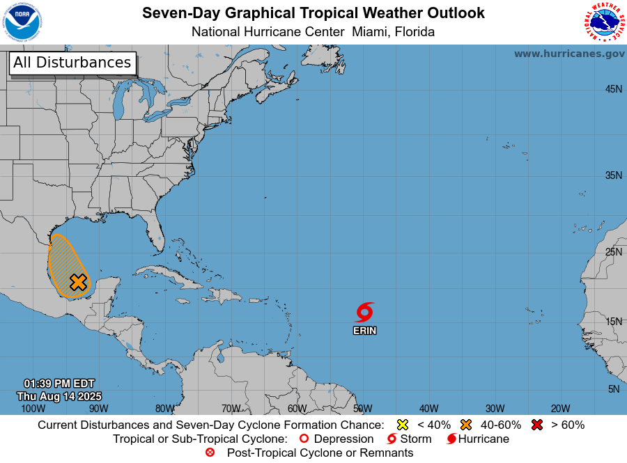
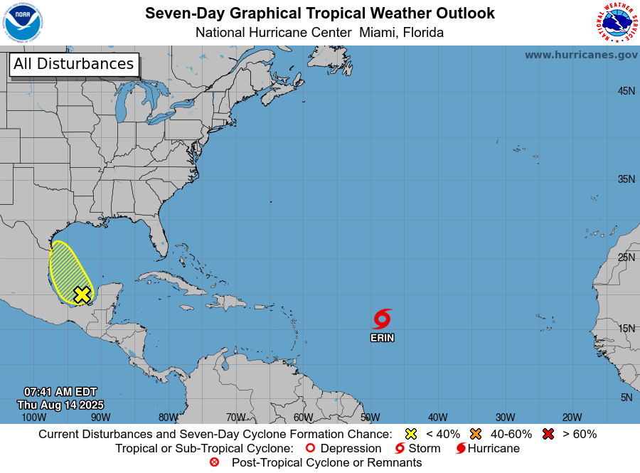
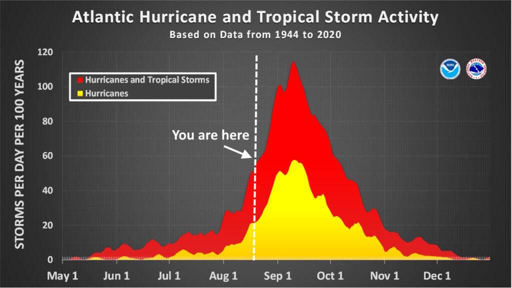
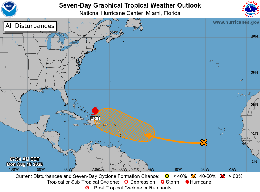
Over the weekend we saw Erin rapidly intensify, going from the Atlantic season’s first hurricane to become a Category 5 storm within 24 hours. Fortunately, Erin remains unlikely to affect any landmasses as it follows a corridor between the North American coast and Bermuda. But the rapid strengthening of Erin indicates that we’ve entered a new phase of the Atlantic season: prime time. For Texas, the next six weeks are by far the period we are most concerned about in terms of when, historically, the largest and most powerful storms have hit the state.

Climatologically speaking, the next six weeks are the busiest of the Atlantic season, including for the Gulf of Mexico. (National Hurricane Center)

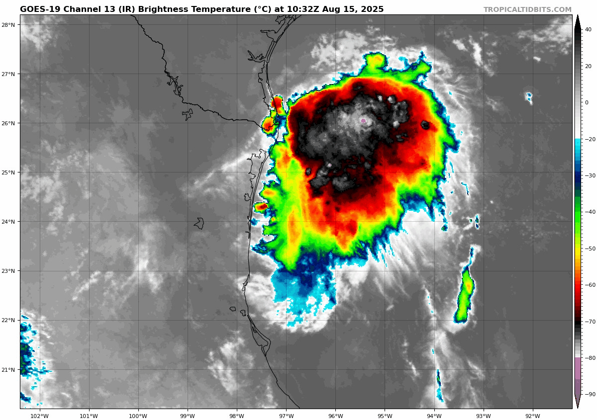
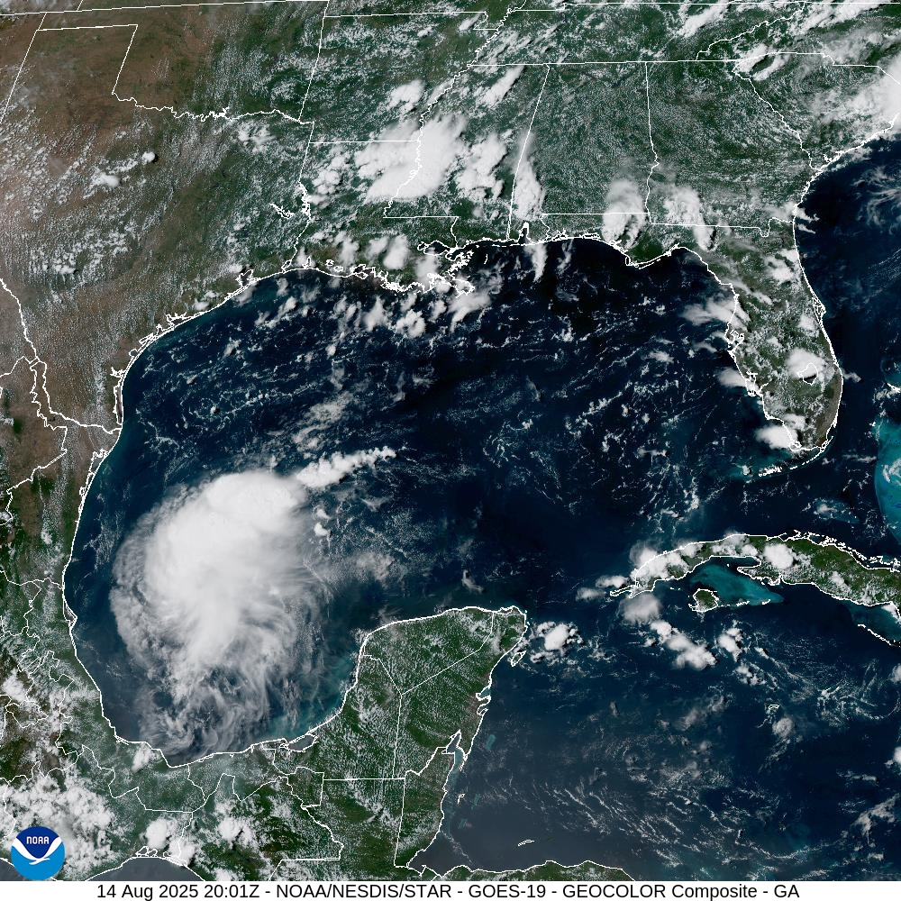
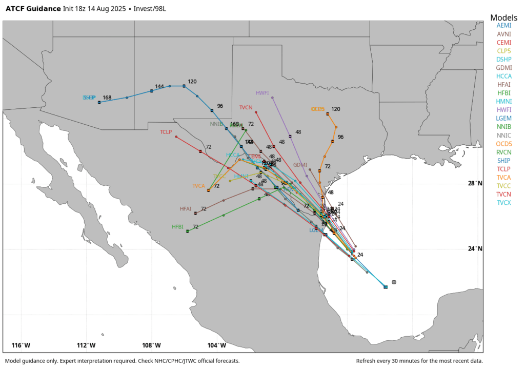
Beyond Erin another tropical system is likely to form in the open Atlantic over the next couple of days. This storm should initialize further south than Erin did, giving it a better chance of approaching the Caribbean Sea, rather than skirting to its north. Although we cannot say anything definitive at this time, the majority of our model guidance has this system turning to the north before reaching the Gulf, perhaps following the same corridor as Erin, perhaps not. We will continue to watch it, of course.

Atlantic tropical outlook for Monday morning. (National Hurricane Center)

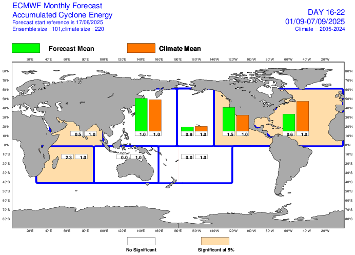
The European forecast center (ECMWF) performs a weekly outlook forecast that looks ahead about a month, and after a busy period through the end of August, it actually is forecasting a bit of a lull in Atlantic tropical activity (approximately 60 percent of normal levels) during the first week of September (see below) and 80 percent of normal levels during the second week. I would not take these weekly forecasts to the bank, but they beat the alternative of an extremely busy forecast.

The bottom line is that, in Texas, we need to pay close attention to the tropics for the next six weeks. Although there are no immediate threats in the coming days, and the outlook for the remainder of August is fairly good, the tropics can always surprise us. As ever, Houston, be wary but not worried about the Atlantic tropics.

Now, let’s jump into the weekly forecast.

Monday

Houston’s high temperature peaked at 101 degrees on Sunday, and the region saw virtually no rain showers. This offered a nice reminder of what August can do down here, but it also was probably the warmest day we are going to see this week.

Monday should be quite hot again with widespread temperatures in the upper 90s due to sunny skies and high pressure in the vicinity. With that said, there is enough instability around to support the development of at least some scattered showers and thunderstorms later this afternoon, probably in the time range of 3 to 4 pm. Some of these storms, although isolated, could be fairly potent so if you have after school activities please be mindful of the potential for thunderstorms. Lows tonight will only drop to about 80 degrees.

Tuesday and Wednesday

High pressure will slowly retreat this week, and that will allow for improving rain chances and gradually lowering temperatures. Tuesday and Wednesday should both be solidly in the mid-90s for most locations however, with partly to mostly sunny skies. Each day will see about a 50 percent chance of showers (mostly during the afternoon) with a few isolated thunderstorms.

NOAA rain accumulation forecast for now through Saturday. (Weather Bell)

Thursday, Friday, and Saturday

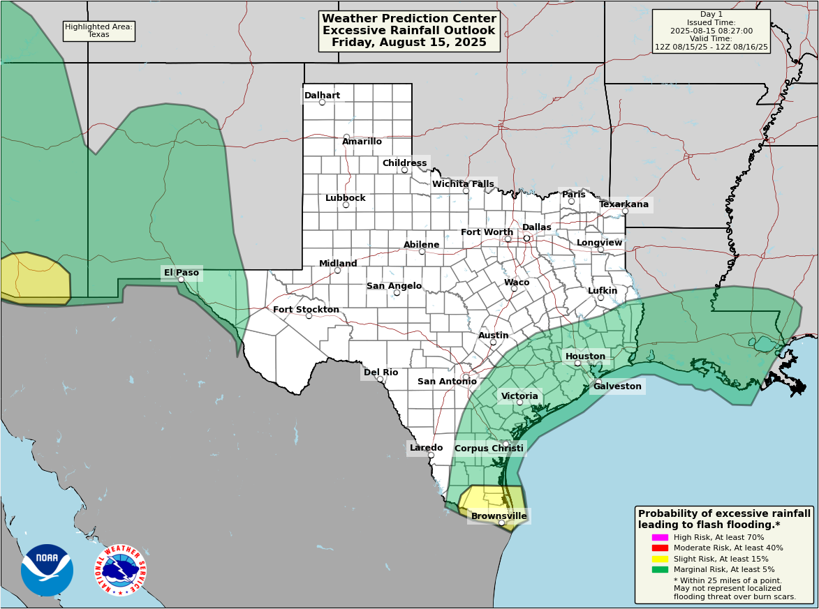
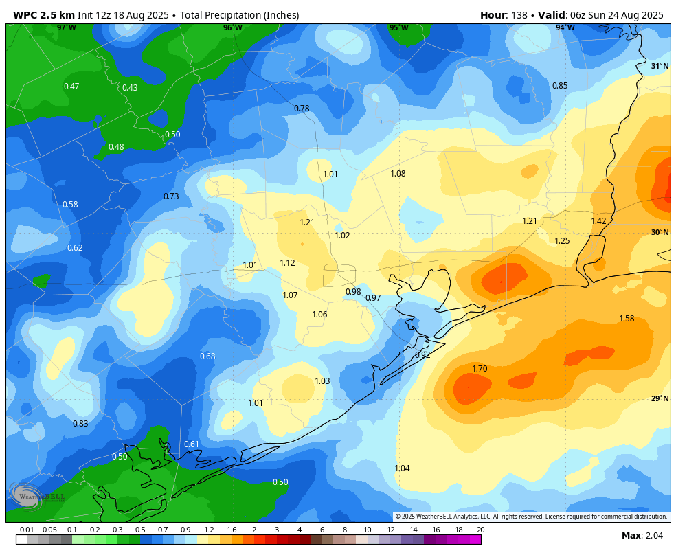
This three-day period should see the best likelihood of rain, with chances generally from 50 to 70 percent daily. This should help drive high temperatures down to around 90 degrees, or just above, for much of the region. In terms of accumulation I would expect much of the region to average about 1 inch of rain through Saturday, or so, but totals will be widely variable. We certainly could see some spotty flooding, but I’m not anticipating major, or widespread concerns. If you’re planning outdoor activities, especially during the afternoon and evening hours, you’ll need to watch the forecast closely.

Sunday and beyond

Rain chances will hang around in the forecast for Sunday and into next week, but they probably will begin to slacken some. With luck our high temperatures will remain in the low- to mid-90s, which is a pretty good way to end the month of August in H-town.

Gulf tropical disturbance to bring Houston an uptick in rain chances, followed by more typical August weather

In brief: Invest 98L, the Gulf tropical disturbance, will bring an enhanced chance of showers or storms to Houston today and Saturday, but nothing much more than that. After that exits, we maintain typical August weather with heat, humidity, and daily shower and storm chances.

Today/Invest 98L

First off, let’s get the elephant in the room taken care of: Invest 98L, the tropical disturbance approaching the South Texas coast is becoming less likely to develop now, particularly because it’s quickly running out of runway to work with. Odds remain 50% per the NHC, though if it does develop, it would be a tropical depression for about 3 to 6 hours or less before reaching land in South Texas.

That being said, it looks somewhat interesting on satellite this morning, conversationally at least.

Invest 98L is basically a gnarly looking blob of thunderstorms. (Tropical Tidbits)

This may look a little scary, but in reality, there is no low-level circulation so while there are some heavy thunderstorms and heavy rain underneath this blob of clouds, the system is not organizing much. So you can disregard any meaningful tropical development (wind, coastal flooding) elements of this for the most part.

What we will watch for at least is rain.

A marginal risk (1/4) for flash flooding exists across the Houston area today, with slightly higher risks closer to the thunderstorms in the Valley. (NOAA WPC)

We don’t expect a ton of storms here today. But as this blob of storms lifts toward the coast, watch for development coinciding with daytime heating from Matagorda Bay up through Galveston, quickly moving inland. The one thing that will probably limit flooding is that storm motion today looks pretty quick. Unless we end up seeing several storms in a row over the same area, expect a few places to see perhaps an inch or two in less than an hour, some quick, minor street flooding, and then hopefully calmer weather. It’s possible that we also see a localized stronger storm with gusty winds as well.

Overall, the impacts of the tropical disturbance should be for a slightly more active August afternoon today. Even on slightly active days, some neighborhoods may not see any rain at all, so that’s possible too.

It’s extremely humid outside this morning as some of that added moisture works into the area. We had some of our warmest overnight lows of summer in some parts of the region yesterday, and we’ll be close to matching or exceeding them today (Jamaica Beach has not fallen below 86 degrees as of this writing for example).

Saturday

With the tropical disturbance dissolving inland, we’ll be left with added moisture and onshore flow Saturday. For now, I’d say this is pretty typical August weather, but I wouldn’t be entirely shocked to see a few repetitive thunderstorms that cause some minor street flooding tomorrow. Otherwise, just look for high humidity and warm to hot temperatures in the 90s.

Sunday & Monday

We should see relatively calm weather here, with just a continued slight chance of afternoon thunderstorms. Coverage should be a little less than it will be today and Saturday however. Highs in the mid-90s.

Rest of next week

High pressure is going to flex and expand in the Rockies and central Plains. This should open the door to some rain and thunderstorm chances out of Louisiana into southeast Texas, combining with sea breezes in the area to keep us somewhat active. Look for mid-90s continuing.

Odds increasing for a tropical storm to form in the Gulf, but it’s really not something to stress about

In brief: The National Hurricane Center has raised the odds of a tropical depression or storm forming in the Southern Gulf during the next day or two. This post seeks to quell any fears this may cause Texas residents. In the greater Houston area we can expect elevated rain chances on Friday and Saturday, but nothing extreme.

Satellite image of Invest 98L as of 3:01 pm CT. (NOAA)

Invest 98L status

Early this afternoon the National Hurricane Center increased the likelihood that a tropical system in the extreme southern Gulf, Invest 98L, will form into a tropical depression or storm during the next two days. The odds this morning were 20 percent, and as of 1 pm CT they are now 40 percent. Accordingly the color of the “tropical blob” on the hurricane center’s site has gone from yellow to orange. This has prompted a number of questions from readers about this system, and a measure of concern.

Hello, orange blob. (National Hurricane Center)

Our most important message is that residents of the greater Houston metro area really should not be concerned.

We will get a better idea about the nature of this system later today when a Hurricane Hunter aircraft flies into it to retrieve data about wind speeds, air pressure, and more. In any case, as of early afternoon on Thursday, the system does not have a closed circulation. However the satellite appearance is improving (in the sense that it is becoming better organized) and there are increasing amounts of thunderstorms. So it is moving in the right direction toward becoming a depression.

Select track forecasts for Invest 98L. (Weather Bell)

It is therefore plausible that this could become a tropical depression or a low-end tropical storm during the next 24 hours. However, by Friday afternoon or evening this should have moved inland, likely somewhere between Brownsville and Corpus Christi. Given this short window of opportunity, we think there is a pretty hard limit on how strong the storm can get.

The primary impacts from Invest 98L will therefore be rainfall. And although we can never be too sure about tropical systems, in August, moving into Texas, this one appears to be largely beneficial in terms of the precipitation it will produce. For the greater Houston region this means an elevated chance of showers, some of it potentially heavy, on Friday into Saturday. Coastal regions face the highest risk, with some areas perhaps seeing a bullseye of 1 to 3 inches of rain. Still, I expect most people will receive less than 1 inch, with the majority of that probably less than 0.5 inch.

More tomorrow.

Daily shower and thunderstorm chances continue as Houston passes ‘hottest’ period of the year

In brief: Summer is by no means over, but based on climatological temperatures we have now crested the peak heating for this year. And there’s no sign of extreme heat any time soon, with highs in the 90s for the foreseeable future and daily rain chances. As Cypress and Klein saw Wednesday, isolated thunderstorms are a possibility as well.

Past the peak

Don’t look now, but fall is on the horizon. We are still about one month away from having any real expectation of a decent cold front, but Houston has passed over the ‘hump’ of summer. The traditionally hottest time of year comes from late July through the first 12 days of August. This is when the average high is 96 degrees. As of today, the average high is 95 degrees. So we are taking baby steps.

I don’t want anyone to be fooled, of course. These are climatological averages, and individual years can bring significant variability. Often times the city of Houston sees some of its hottest daytime temperatures of the year in late August and early September. However, the average temperature is lower due to shortening days and the occasional weak front. All of this is to say that we are getting through summer, y’all. And the good news is that, for now, we don’t have any 100-degree weather in the forecast.

All things considered, this is not a bad high temperature forecast for mid-August. (Weather Bell)

Thursday

What we have in the forecast for today is a decent chance of showers, especially closer to the coast. By now you’re familiar with this pattern. Somewhere in the region this afternoon, or early evening, we’re likely to see a decent cluster of showers and thunderstorms. Most of the area won’t see any rain, or just some light sprinkles. But a few places—yesterday it was Cypress and Klein—might pick up 1 to 2 inches. This is likely to be the setup later today as well, and it’s precisely what I mean when I say we will have scattered showers and isolated downpours.

High temperatures will depend on the extent of shower coverage later this afternoon, but most of us should see highs in the low- to mid-90s, with plenty of humidity of course. Nights have been really warm of late, and I expect most of the city will not drop below 80 degrees tonight. Winds remain light, outside of thunderstorms in which there can be strong gusts.

Friday and Saturday

You may have noticed a ‘tropical blob’ highlighted in the Gulf by the National Hurricane Center. This remains unlikely to develop into a tropical depression or storm, and it has a limited window before moving into Mexico or southern Texas late on Friday. (If there’s a significant change to this outlook, we will update the site immediately. But we don’t expect this to happen).

Regardless of development, this system will inject a little more moisture into our area. This should raise rain chances to 50 or 60 percent on Friday and Saturday in the greater Houston area. Overall accumulations will still be on the order of one-half inch (or less) for most locations. But just know there could be some disruptive showers pulsing through. High temperatures for most of the region will top out in the lower to mid-90s on Friday and Saturday.

Sunday and beyond

By the second half of the weekend some high pressure is going to try and work its way into the area, but I don’t think our daily weather is going to change too much. We are likely to see high temperatures generally in the low- to mid-90s (a few far inland areas may push into the upper 90s) with a smattering of afternoon showers and thunderstorms. It should be fairly typical for mid-August in Houston, and as we’ve discussed before, any time we get ‘boring’ weather during this time of year we’re doing very well.

Tropical outlook for Thursday morning. (National Hurricane Center)

Atlantic tropics

I’ve already mentioned the Gulf tropical low above: It’s not a major concern for us, or probably anyone. Then there is Tropical Storm Erin, which is on its way to becoming the season’s first hurricane. It is likely to pass north of the Caribbean Sea. It will approach the southeastern United States next week but probably (although not yet certainly) curve before reaching the mainland. Bermuda faces a definite risk next week from Erin. Beyond this there are no imminent threats and the Gulf looks quiet for the next 10 days or so.