Typical August weather continues for Houston as Atlantic tropics continue to wake up

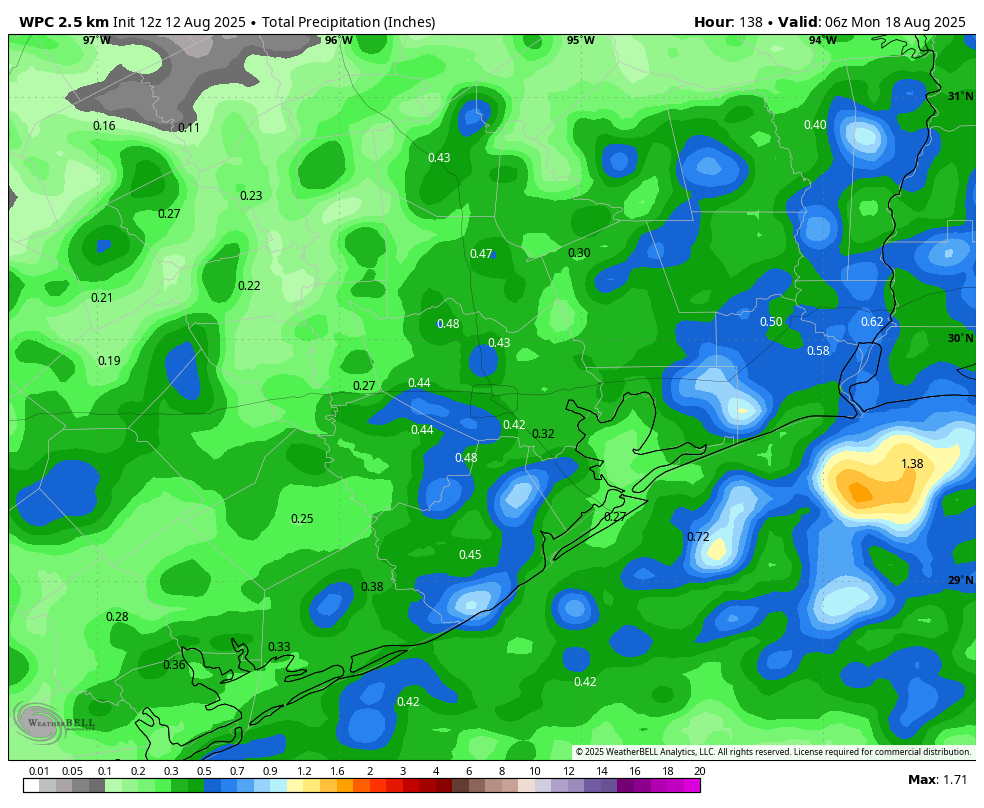
In brief: Parts of central Houston saw some fairly strong showers and thunderstorms on Tuesday, with a few isolated areas picking up 1 inch, or more, of rain. That pattern of sporadic afternoon storms should occur through Saturday before high pressure asserts a little more control. We also discuss the chances of a tropical system forming in the southern Gulf late this week.

Wednesday

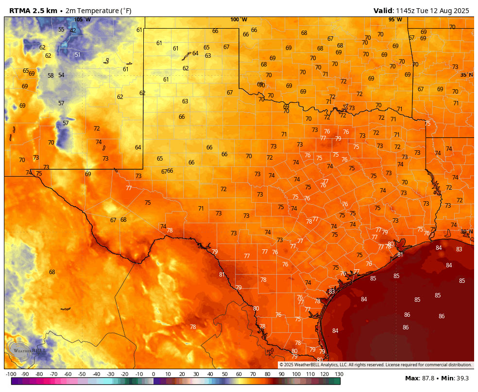
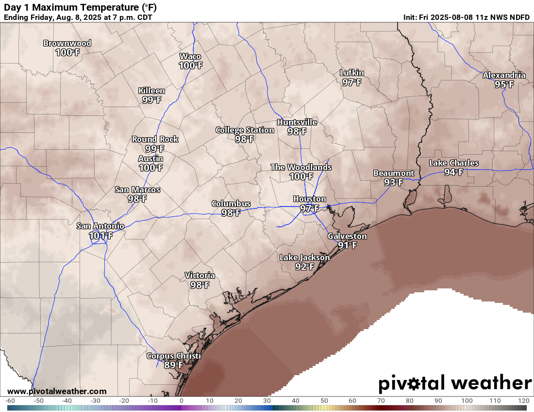
The overall story remains the same for Houston’s weather in the coming days, with hot weather and just enough instability and moisture to support the possibility of scattered showers and isolated thunderstorms. These storms are most likely during the afternoon and evening hours, at a time when kids are coming home from school, participating in after-school activities, or during the evening commute. Today, however, I expect slightly less coverage than we saw on Tuesday. Overall I would say there is about a 30 percent chance of showers, with isolated storms. Highs today will range from the lower 90s near the coast to the upper 90s inland, with plenty of humidity.

Wet bulb globe temperatures remain in the “high” range this week, but that is typical for August here. (Weather Bell)

One thing that’s been noticeable this summer, to me, is the lighter winds. This is because we have not seen tight pressure gradients (i.e. very strong pressure systems) to really draw in the onshore winds. Today, for example, winds will come from the west at about 5 mph, with only slightly higher gusts. Winds may be a little more pronounced on Friday and Saturday, but overall they look to remain in the 5 to 10 mph range for quite a while.

Thursday and Friday

The forecast remains similar to end the work week, with highs in the 90s. Thursday and Friday may see slightly better rain chances, with 50 percent coverage of showers, and a few embedded thunderstorms. The most likely period for these showers remains the afternoon.

Saturday and Sunday

Saturday should see a continuation of this pattern, with highs in the mid-90s for most locations and a healthy chance of showers and thunderstorms. As high pressure starts to build some, I think most of Houston may push into the upper 90s on Sunday, with decreased (but non-zero, to be clear) rain chances. All in all this should be one of our hottest weekends of the year, which is to be expected in mid-August.

Next week

Temperatures for most of next week look hot, in the mid- to upper-90s, with lots of sunshine. I think rain chances will take a step back toward the 20 to 30 percent daily range. So yeah, full-on summer for Houston.

The Atlantic tropical outlook, now featuring a Southern Gulf of Mexico blob. (National Hurricane Center)

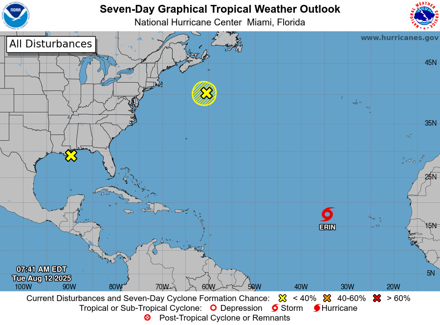
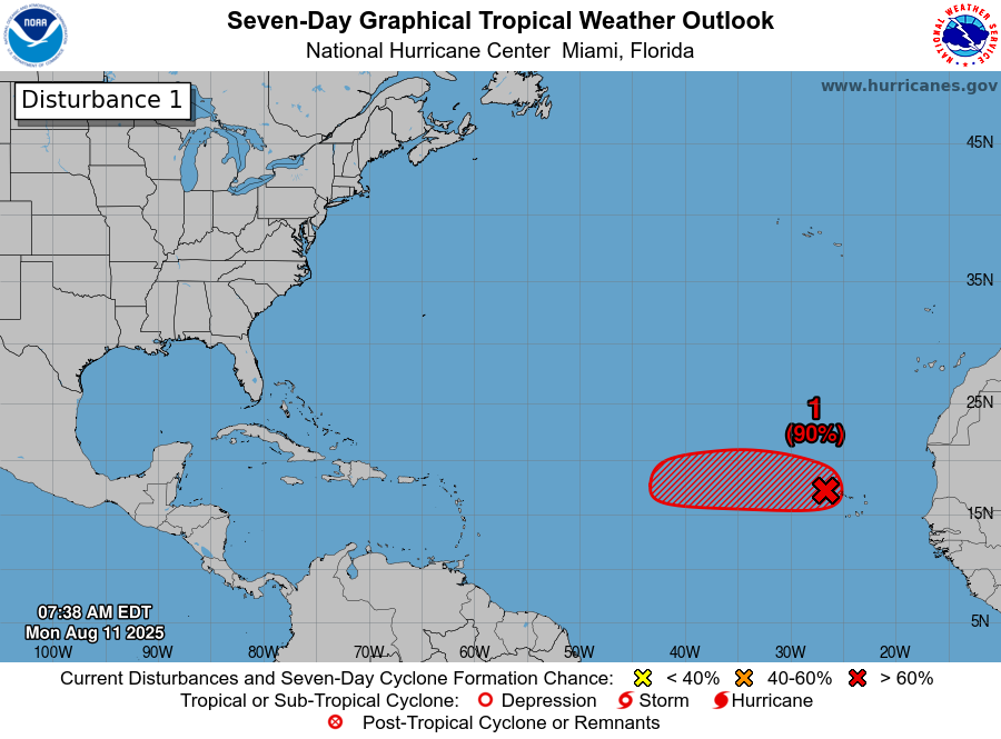
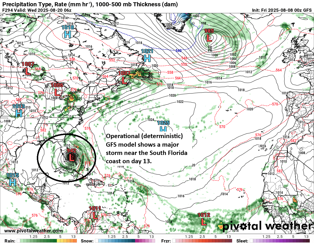
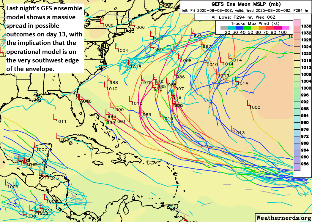
The tropics come alive

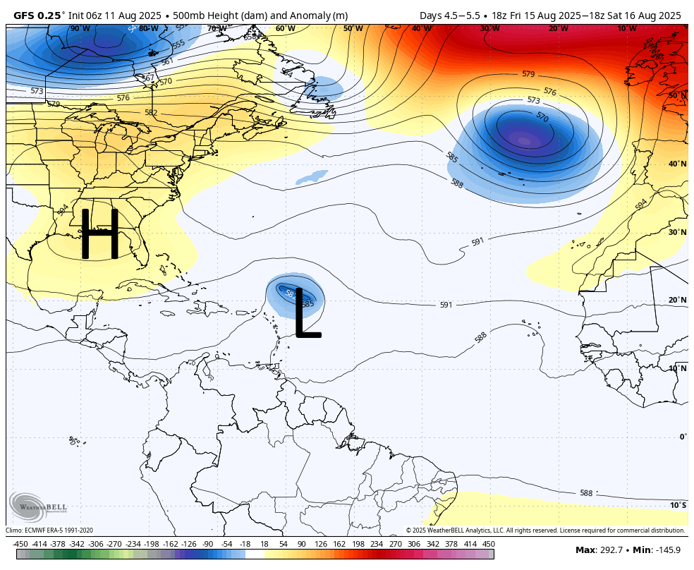
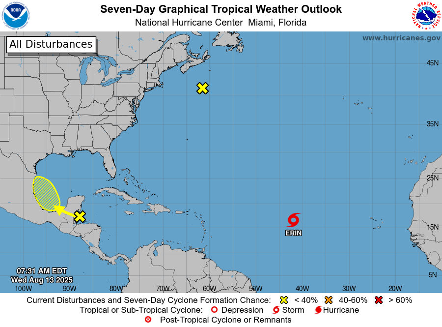
In the Atlantic Tropical Storm Erin continues to struggle with the intrusion of some drier air, but should soon move into more favorable conditions. A hurricane is likely to form later this week, or this weekend. The majority of modeling still shows the system turning before threatening the United States, but Bermuda is definitely at risk.

The European model ensembles indicate a low-end chance of something developing in the Bay of Campeche on Friday. (National Hurricane Center)

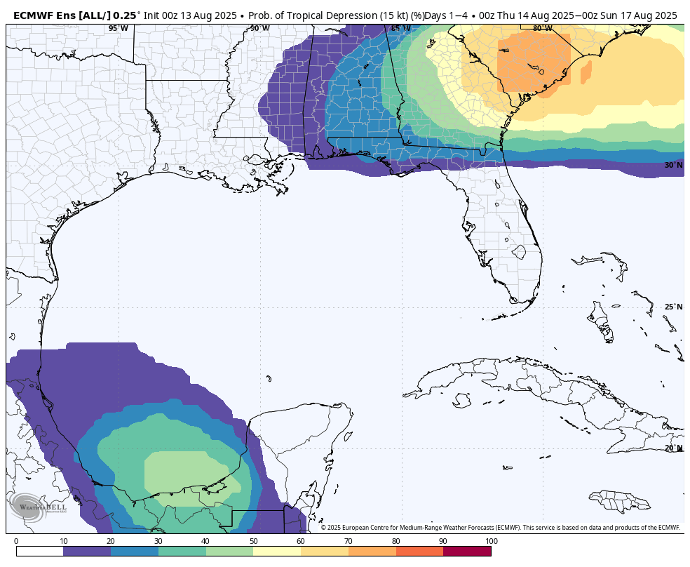
Additionally the National Hurricane Center is tracking a low pressure system that should emerge into the Bay of Campeche on Thursday or so. There is a slight chance of some development over the southern Gulf, and you always want to keep an eye on anything in that region in August. However, none of the models are particularly excited about this tropical low, and the atmospheric conditions are not super supportive. So, at this point, the most likely scenario is that the low has minimal to no impact on our weather. We’ll see.

August heat continues, and we finally answer our most asked questions

In brief: In today’s post we discuss our ongoing heat and decent rain chances, as well as a new tropical blob in the Gulf (which is not at all an issue for us). Also, we’re excited to share our first stab at a list of regional weather web sites, for other locations, that are similar in tenor to Space City Weather.

Regional weather sites (and other notes)

One of the most frequent questions we hear at Space City Weather goes something like this: “I’m moving to [insert destination] and I’m trying to find a weather blog there just like Space City Weather. Can you help?” Unfortunately, short of a handful of destinations we really could not.

So over the last few months our Dwight Silverman has been digging for independent, locally focused sources weather information. To qualify these sites also need to provide quality information (surprise, there’s a lot of junk out there) and be regularly updated. The end result of this is a page, which we will regularly update, that provides links to recommended regional weather sites. We welcome suggestions for sites to add, which you can provide at this Discourse comment thread.

While we are discussing site housekeeping notes, I also want to remind readers to make sure you’ve downloaded the latest version of our app. We think we have finally solved an issue that led to crashes on some iOS devices. Additionally, don’t forget that we’ve migrated our comment system over to Discourse. The goal is to make it easier for us to moderate conversations, highlight thoughtful contributions, and cut down on off-topic noise. 

Only the Panhandle is seeing slightly cooler weather this morning in Texas. (Weather Bell)

Tuesday

If your child is heading back to school today, rain showers have remained offshore for the most part this morning. So we’re left with a warm, and humid start to the school year—as is often the case during August. Skies will be mostly sunny this afternoon, allowing highs to reach the mid-90s for most of the region. Far inland areas may nudge up into the upper 90s, whereas coastal areas will top out in the lower 90s. Some scattered to isolated showers will be possible later this morning and into the afternoon hours, but I would put overall chances at only about 30 percent. We may see a few isolated downpours, but for the most part these should be light to moderate rains. Winds will be light. Lows tonight will only drop to around 80 degrees.

Speaking of tonight, the Perseid meteor shower peaks on Tuesday night, with the optimum time for viewing from 1 am to 5 am on Wednesday morning. We should be in luck with largely cloud-free skies, but a waning Moon will unfortunately provide some unwanted extra light. As always, viewing a meteor shower is best far from bright city lights.

Wednesday, Thursday, and Friday

The story remains largely the same for the rest of the week, with high temperatures generally in the mid-90s, mostly sunny skies, and spotty rain chances. Most of us probably will see at least some shower activity this week, especially closer to the coast. But for most of us accumulations will be at or below 0.5 inch. Nights (of course!) remain warm and muggy.

NOAA rain accumulation forecast for now through Sunday. (Weather Bell)

Saturday, Sunday, and beyond

As high pressure expands westward this weekend, we may see a few more high temperature readings in the upper 90s. But we should also still see some scattered daily shower chances, perhaps on the order of 30 percent daily. All in all, it should feel like a typical August weekend, which is to say hot, mostly sunny, and very humid. This pattern will likely continue into the start of next week.

Atlantic tropics

As expected, we are seeing the tropics come to life. Tropical Storm Erin formed on Monday, and this probably will become the season’s first hurricane within a couple of days. Erin is expected to track north of the Caribbean Sea. And while there is a non-zero threat that the storm moves toward the southeastern United States (probably less than 10 percent), at this point the biggest concern I have is in regard to Bermuda about one week from today. To be clear: there is no threat to the Gulf from Erin.

Atlantic tropics outlook as of Tuesday morning. (National Hurricane Center)

Speaking of the Gulf, there is a yellow X there this morning. However, as Matt pointed out on The Eyewall last night, there is a mountain of wind shear in the western Gulf right now, and the eastern Gulf isn’t exactly hospitable either. So this is just a run-of-the-mill surface trough interacting with warm water and hot, humid Gulf weather, producing lots of thunderstorms. It should slowly lift away from Texas toward the northern Gulf coast. So not at all a threat locally.

Fairly widespread showers likely today across the region

In brief: Houston will see a pattern this week of typical August temperatures, and daily shower chances. We may also see a few isolated downpours and strong winds each day. By this weekend high pressure should begin to build over the area, pushing temperatures up and rain chances downward.

Pattern overview

High pressure will develop over the Florida region during the next couple of days, and this area will gradually expand westward this week across the Gulf. What this means for Houston is that, through the coming work week, we will see enough “weakness” in the pressure pattern to allow for healthy daily shower chances with a few strong, embedded thunderstorms. This is the kind of weather some areas, such as Sugar Land, experienced on Saturday withy isolated strong storms.

This somewhat unsettled pattern should keep high temperatures this week in the mid-90s, but we could be headed toward hotter temperatures this coming weekend, when the ridge of high pressure expands far enough west to begin directly influencing our weather.

High pressure should expand over the Gulf of Mexico this week. (Weather Bell)

The aforementioned high pressure system’s placement over the Gulf will also play a role in the evolution of a tropical system now known as Invest 97L, but which is likely to become a tropical storm in a couple of days, and later a hurricane. This system is not much of a threat to reach the Gulf, but the placement of the high will help determine whether Invest 97L approaches the eastern United States or remains well offshore.

Monday

A quick look at the radar this morning shows plenty of showers offshore and to the east of the city, and these should gradually spread into the Houston metro area later this morning. As will be the case much of this week, the showers will be hit or miss, with a few embedded thunderstorms. By this afternoon we should see mostly sunny skies with high temperatures in the low- to mid-90s for areas along and south of Interstate 10, and mid- to upper-90s for inland areas. Winds will be fairly light, at 5 to 10 mph, generally from the south. Overnight lows may briefly fall below 80 degrees.

Tuesday through Friday

Our weather for much of the week will basically be rinse and repeat: highs in the mid-90s for most locations, and a decent (think 40 to 50 percent chance) of showers daily. For most of us, the showers will quickly pass, but there could be isolated, heavier downpours. Since we’re in the middle of August it’s going to be plenty humid with very warm nights. Skies will be partly to mostly sunny.

Saturday and Sunday

As high pressure builds heading into the weekend I believe we are likely to see decreasing rain chances and rising temperatures. Expect mostly sunny skies this weekend, with high temperatures generally in the upper 90s for areas away from the coast. If you’ve been waiting for (or dreading) the summer sizzle, it appears to be headed our way.

Next week

If high pressure does start to more directly influence our weather, how long will it last? That’s a question I really cannot answer, but there are at least some small indications that perhaps a rainier, slightly cooler pattern will return by the middle of next week or so. At least that’s the hope I have. We’ll see.

Invest 97L is on the cusp of becoming a tropical storm. (National Hurricane Center)

Atlantic tropics

The big storm everyone is watching this week is Invest 97L, which I mentioned in the introduction. I think there’s a good chance this will become the season’s first Atlantic hurricane, but for now it’s eventual forecast remains uncertain. What we can say is that it is almost certainly not a threat to the Gulf, or Texas. Matt will have plenty more information on this system all of this over at The Eyewall.

A rather typical early August weekend awaits Houston while we take a detailed look at the tropics

In brief: Hot and humid weather with daily shower chances awaits Houston over the next several days, typical for August but perhaps encroaching on 100 degrees at times. Today, we also dive in deep on the tropical noise that’s been percolating on some weather models.

IAH hit 100 degrees again yesterday. Before you go stand outside Terminal B with pitchforks due to construction the perceived hot bias, there were a string of 99s and 100s yesterday recorded across the north and west side of town. Wednesday’s 100 felt a little less valid. But again, compare IAH to IAH, not to the rest of the city. We saw mid to upper 90s mostly, and we’ll probably do it again today. Nothing unusual for August.

Today

We’ll have one more slightly hotter than usual day today with highs approaching 100 degrees in spots, especially north of I-10. Isolated to scattered showers and thunderstorms are likely with daytime heating again, and any of those storms could produce some brief downpours and the potential for some gusty winds.

Forecast highs for today will be toasty. (Pivotal Weather)

We may still have residual haze, especially this morning. That’s due to wildfire smoke from Canadian wildfires. This is a problem that much of the country has been dealing with at times in recent years.

Weekend

Both days should be fairly typical for August. We’ll see highs in the mid to upper-90s, possibly leaning more toward mid-90s on Sunday with slightly higher coverage of showers and storms. But, sunny, hot, and humid with daily isolated to scattered downpours and thunderstorms.

Next week

There’s nothing particularly notable about next week’s weather right now. It looks like we’ll have a few isolated to scattered showers or storms each day, especially on Monday or Tuesday. Temperatures may try to rebound back closer to the upper-90s again. But overall, it looks like very basic August.

Tropics

First and foremost, we’re good here for the next 7 to 10 days in Houston. We’ve got no concerns noted on modeling right now.

All that said, it’s getting to be the time of year where we do start watching more and more things, even some of the innocuous looking ones. We’ve had some deterministic (operational) model guidance (the GFS, the Euro, etc.) go crazy in the day 14 to 16 timeframe lately. This bears repeating. The day 14 to 16 timeframe. Deterministic modeling has virtually no skill at that timeframe. So, while we are certainly empathetic to people getting a little unnerved when they see bad things in that timeframe, Eric and I both are realists and recognize that those runs, even if 2 or 3 in a row show something similar, are somewhat meaningless. Put another way, if I had a buck for every time a deterministic model wrecked a major Gulf Coast city on days 14 to 16, I’d be getting wrecked on some tropical island somewhere far, far away living the dream. I’m just saying!

So what do we do instead? We look at ensemble guidance for clues. What can the ensembles tell us about the potential for a tropical system in a more distant timeframe? Ensemble modeling is where you take a single model and run it 30 to 50 times but tweak the initial conditions, or what the model starts from. We can’t get a perfect snapshot of the entire atmosphere over the entire globe, so we have to improvise a little. Ensemble guidance is that improv.

Okay, let me show you a perfect example of this. Here’s last night’s GFS operational model for hour 294, which is day 13.

Last night’s operational GFS model shows a major storm near Florida on day 13. (Pivotal Weather)

That’ll get your attention! And it has been showing this for a few days, though it varies in location between the Caribbean, the Carolinas, and out to sea. But what do the ensembles show?

Zero agreement on track or intensity of system on day 13 per the 30+ GFS ensemble members. (Weathernerds.org)

Not all lines on a spaghetti plot chart are created equal. Some of the lines above may be ensemble members that are slightly more skilled than others. That’s a tough lift to figure out specifically in every situation. But the point is this: Yes, the GFS operational model may be right! But according to the ensembles there are a bunch of other options too, including many that go out to sea and a handful that come into the Gulf.

I show you this for a couple reasons. First, I want you to recognize that the scary images you often see on social media are almost always from operational models. Second, when you look at the ensemble guidance, it offers a far more nuanced take on all this that suggests the operational models are just one possible solution of many. We go through this exercise every season. It’s the same culprits from the same places with the same intentions. They’re basically preying on people’s fears to drive engagement under the guise of “we’re not saying this is a forecast (it is), but we want to just let you know what’s out there!” In reality, the picture is nuanced, complex, and not at all straightforward. A deterministic model showing Armageddon on day 13 does not make that scenario any more likely than any of the possible outcomes on the ensemble chart I showed you above. Hurricane season is a months’ long marathon. We just want you to keep your sanity.

In this specific situation: Yes, we should keep an eye on this tropical wave as it comes west over the next 10 to 12 days. It is August, and we should keep an eye on all tropical waves this time of year. Rest assured, if there’s a threat that seems realistic to Texas, we’ll be talking about it here well before it happens. You can also use The Eyewall to follow along with more of the day-to-day details.