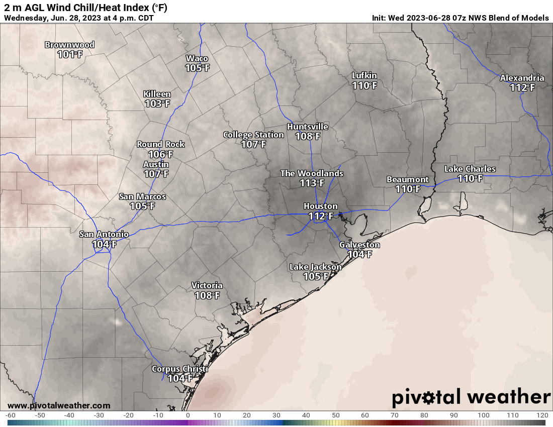
We logged a pair of 99s yesterday at both Bush and Hobby, with maximum heat index values of 107 to 110 degrees. Temperatures have been hitting the forecast mark at night, with lows of 81° yesterday at both sites, but we continue to miss daytime highs by at least 1 to 3 degrees. Still, the heat index or “feels like” temperature has been verifying close to forecast. It’s been one of the more interesting heat waves in terms of forecast accuracy that I can recall. And it continues.
Today through Saturday
The forecast is pretty unchanged through Saturday. As we’ve been discussing all week, it looks pretty stable each day, with highs near 100 and lows near 80 each morning. Rain chances remain near zero. Hopefully we can maintain something more at heat advisory criteria than excessive heat warning criteria, but that will depend on the exact nuance of each day. Continue to practice heat safety.
Sunday
We continue to look for our transition out of this pattern to begin on Sunday. While showers and storms aren’t exactly likely, there’s at least a chance slightly greater than zero. Highs will likely maintain near 100°, with lows near 80 in the morning.
Monday
We see an even more significant collapse of the dome of high pressure over Texas off to the south and east on Monday, meaning it weakens and pushes away.
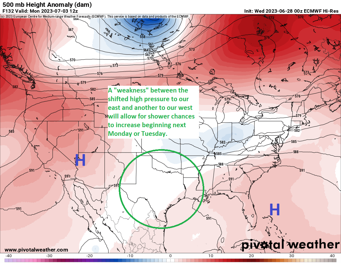
This will open up the door to a “weakness” in the atmosphere that will allow for more moisture and a better chance of showers and storms by the afternoon. These probably won’t be the same type of storms we saw last week, where they rip out of the north and hammer us with severe weather. Expect something more traditional for Houston summers, with hit and miss afternoon downpours and a fair bit of lightning.
Rest of next week
For July 4th festivities, there will definitely be a chance of showers or storms during the afternoon. I would have a backup plan in place indoors, just to be safe right now. I would absolutely not cancel anything though. We’ll offer more color on that outlook tomorrow and Friday. More shower and storm chances will continue into mid and late week. We may even add some tropical moisture to the mix at some point to enhance showers, but that is very much TBD.
We do continue to see signs that high pressure in the upper atmosphere may again try to exert itself over Texas after next weekend, but whether that means super hot and dry again or just generically hot with fewer rain chances remains to be seen. Next week’s cooler change looks more temporary than permanent right now.


Matt, that’s an interesting comment about this heat wave in terms of forecast accuracy. I’d be interested in your thoughts on what might be driving this. Increased computer modeling sophistication? Increased satellite / radar data and imagery? More historical data in a period of warming temperatures? Sheer luck? Other?
PS – the post on the June storms was very informative and helpful! Thank you.
Thanks, Jon! We’ve noticed that they’ve improved the models in recent years by making them higher resolution, but by doing so, they almost overamplify the urban heat island effect sometimes. It’s like if the model sees hot & dry, it attempts to take temps to the moon. But we correct for that in our forecasts, though apparently not enough. I will say, the models did imply that this would be an awful stretch of heat index/humidity, and that has verified very well. Sometimes they hit and miss simultaneously ha.
Matt,
Maybe it’s the elevated winds that I have noticed that’s keeping the temps a few degrees off from the forecast.
If that were the case then it would have been mentioned
It often rains on the Fourth of July, but it’s usually the typical later afternoon and early evening brief showers that come during the spring and early summer in Houston, I remember many years wondering if fireworks would be cancelled.
Matt/Eric — From yesterday’s post — how did that 110 degrees for 32 hours happen/that there was no cool down overnight?
That number isn’t for 32 straight hours of 110+ degrees, It’s for 32 cumulative hours of a heat index above 110 degrees.
So that number is calculated by adding up the total number of hours in the entire year that was spent at or above a 110F heat index.
As Sonora says, yes, it’s 32 hours in total for a period. So you get something like 2-5 hours of that in a day it adds up to 32 over the course of the entire month, year, etc.
Aha, thanks, both! That makes much more sense. I missed cumulative vs. consecutive in there.