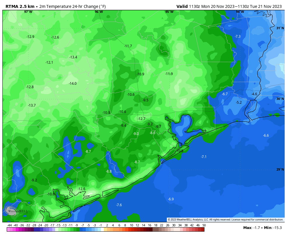
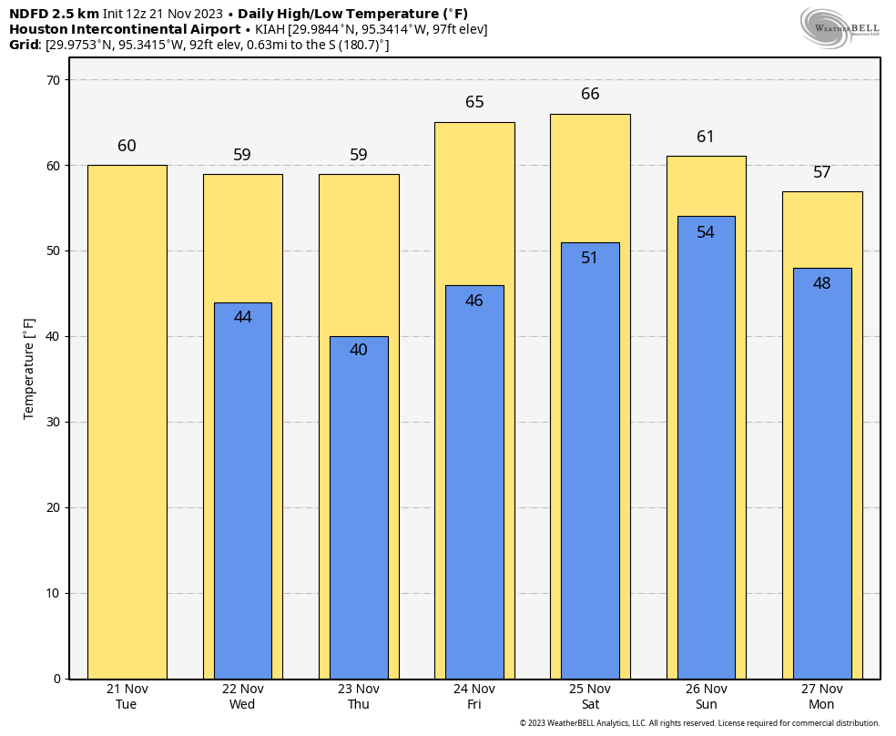
Good morning. Temperatures are 10 to 15 degrees cooler outside this morning than on Monday, and this is only the beginning of a cool down that will more or less persist for the rest of November, at least. The Houston region is not going to see freezing weather any time soon, but highs are unlikely to surpass the 60s and low temperatures should be consistently in the 40s and 50s. So this is chilly for November, and pretty much characteristic of average conditions during winter months. If you’ve been waiting for consistent sweater weather, you’ve made it.

Tuesday
The story of today, beyond the cooler weather, will be the wind. Winds out of the north will blow consistently at 15 to 20 mph, with gusts up to about 30 mph in the wake of the front’s passage. Temperatures will peak at about 60 degrees, with mostly cloudy skies. The wind will back off a bit this evening, with temperatures dropping into the mid-40s overnight.
Wednesday
We’ll see some sunshine on Wednesday, particularly during the morning hours. That will help temperatures recover into the upper 50s, at least, for most of the area. Winds will be less, too, perhaps at 10 mph from the north. Lows on Wednesday night will likely be the chilliest of the week, dropping into the low 40s.
Thanksgiving Day
After a cold start, we’ll see some warming on the holiday, perhaps into the upper 50s. However, mostly cloudy skies will inhibit warming beyond that. Winds will be light. The atmosphere is going to be a bit disturbed with an upper-level low pressure system, but I don’t think we’re going to see any onshore showers as atmospheric moisture levels remain fairly low. However, know that there is a slight possibility of some light rain on Thanksgiving. Overnight lows will drop to around 50 degrees in Houston, with cooler conditions further inland.
Friday
Mostly sunny skies should return for Friday, which will allow highs to push into the 60s. Lows on Friday night will be a bit warmer, perhaps in the low 50s.

The weekend and beyond
Saturday will feel warmer as the onshore flow resumes, bringing more moisture into our atmosphere and increasing cloud cover. Look for highs generally in the mid-60s to upper-60s. I expect Saturday to remain rain free, but some light showers will be possible by Saturday night, although they likely will not start until after midnight.
Sunday will be in the 60s as well, with the potential for scattered showers ahead of the next front. I’d say there’s about a 40 percent chance of rain on Sunday and Sunday evening, although accumulations will be light, perhaps on the order of perhaps one or two tenths of an inch. Said front should arrive on Sunday evening or a bit later, and will bring significantly drier air into the region, ending rain chances.
The forecast is still a bit hazy, but generally we should see highs in the 60s and lows in the 40s and 50s next week, with partly sunny skies. Keep those sweaters handy.
Fundraiser
We’re still in the midst of our annual fundraiser! Thank you to everyone who has supported us so far, and you still have the opportunity to buy merchandise or make a donation at our online store.


Hallelujah!
Looks like a good couple of days to get the yard in shape during staycation.
terrible time to get the yard in shape, because it is so wet and the branches are falling like crazy.
So wet!!!!??? I don’t know where you live, but I’m still watering and the only branches on my land are from the drought!!
I think he is one of the lucky ones whose area got decent rain amounts
Loving the winds and cooler weather. Now this is what Thanksgiving week should be like.
Food, nap, walk, avoid shopping malls, repeat.
I am remembering our horrible heat and and most GRATEFUL for our cooler temperatures. Nothing to complain about now!!
Ok I’ll complain. Too chilly. My O.O.T. visitors expect warm. And we’re down 16” at Hobby. Still severe drought. These dry fronts are not good. This El Niño may be a strong one per the SSTs in pacific zones 3, 4 but SSTs are anomalously hot all over. We’re not getting the usual attendant troposphere effect. When is this blog going to discuss macro patterns in this new climate, i.e southwest desert….hahahaha. That discussion would be useful.
I read an article that said that we probably will start seeing the wetter weather pattern typically associated with El Nino finally emerge once we get deeper into the winter. But you never know because of the fact that this is an unusual ESNO event because of the hot SSTs all over the Pacific. The only thing I can say is that not every strong El Nino fall was super wet across SE Texas. The El Nino of 1982-1983 was a strong one, but the fall of 82 was not very wet atleast along the coast. The following winter was pretty wet though. What is concerning is that La Nina almost always follows an El Nino year. If we don’t get the rain we need this Winter and Spring, it could turn ugly for Texas. I don’t want another 1950s ” 7 year drought” to happen again in Texas.
Good – useful comment. I’m just looking out for Wayne’s water well. He’s just about emptied it and the ridge is going to come back strong. LOL
I really hope not. I’m tired of ridges already lol
FYI for anyone else curious about ship-by dates for the fundraiser merchandise, the details are on each product page after you click around — looks like December 14th, if you’re shopping for holiday gifts for weather fans. 😉
I think the shipping software charged sales tax on the freight charge. Is that correct?