In brief: A few showers will dot the radar around Houston today and tomorrow. We’re optimistic that Mother’s Day will turn out mostly fine. But next week? It’s gonna get hot, like June or July-type heat.
SCW Flood Scale
I want to start off with a quick note today. If you’ll recall, back in January of 2023, I had posted that I gave a talk about the SCW Flood Scale at the American Meteorological Society’s annual meeting in Denver. We said we might have some opportunities to partner up with some experts to improve the scale. We love the scale, and we know you do. And while it works, we came up with it ourselves. It’s rooted in what we thought worked. Well, the goal was to get it rooted in science.
Thanks to the passion and interest of Dr. Steven Woods, the director of the Cognitive Neuropsychology of Daily Life Laboratory at the University of Houston and his PhD student, Natalie Ridgely, we may have a solution. Natalie conducted a bevy of research to understand how people consume weather information. Natalie just successfully defended her dissertation research this week, much of which comes out of her work that uses our flood scale and proposed modifications to it! I was honored to serve as a member of her dissertation committee, and I cannot wait for Natalie and Dr. Woods to share more details on this in the weeks and months ahead. Natalie’s findings are fascinating and illuminating and will become a great contribution to both neuroscience research and research of the societal impacts of meteorology. And they’ll have a permanent impact on our flood scale. Congrats to Natalie! More to come.
Overnight storms
So, yes, last night we had a few hours of storms right across the middle of Houston. Many of you missed out, but many of you participated. Thankfully, they were not severe, but they certainly had some noise — and rain.
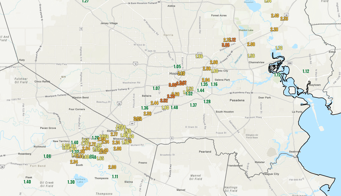
The big winner was the area between the Med Center and UH, where a max total of nearly 4 inches occurred. A secondary maximum was just west of Sheldon. Rain rates were on the order of 2 to 4 inches an hour. They were some hefty downpours. Some pockets north and west of downtown also saw around an inch or so, but for the most part it was that corridor that got soaked.
Today
We have one last little broken line of showers rolling through the area now. Some heavier downpours are occurring southeast of the city across Brazoria County.

These will exit over the next couple hours, giving us a quiet middle of the day. With any sunshine will come some additional showers and perhaps storms today. The best odds of showers later today will probably be north of I-10, probably across Montgomery, Walker, Liberty, and San Jacinto Counties. With low pressure in the upper atmosphere over Louisiana, these showers will basically drop north to south.
Saturday
It looks like one little disturbance in the upper atmosphere is going to pivot around the upper low in Louisiana tomorrow, so I think our odds of scattered showers or thunderstorms actually may go up a bit, relative to this afternoon. These would probably pop up in the late afternoon and evening hours. So just have an umbrella handy for any Saturday evening plans. Look for highs in the upper-70s to near 80 degrees.
Mother’s Day
Drier air is going to begin pushing into the area on Sunday. I don’t want to completely take a rain chance out, especially east of I-45, but any showers on Sunday should be fleeting. And overall, any plans you’ve got should have minimal to no weather disruption with mostly sunshine otherwise. Highs should top out near 80 or so on Sunday.
Next week
Welp. There’s almost always a week in May where it becomes apparent that the season is about to change. Next week should be that week. Monday looks great, with a cool morning, highs in the lower 80s and comfortable humidity. By Tuesday we bounce into the upper-80s. Wednesday? Low-90s. Thursday we head into the mid-90s. And to be honest, I would not be shocked if we end up in the upper-90s by Friday or Saturday.
These will begin to approach record highs. The humidity should also transition back above normal later next week, probably making it feel a bit more uncomfortable. It should hopefully fall short of the intense heat and humidity we saw last May, but either way, brace yourselves, summer is coming.

Ready for our last blessing of spring this Monday before the long slog begins, hopefully it isn’t 110 degree heat indexes like May 2024.
Sadly it probably will given the current climate trends we live in now.
Last night we finally got the rain which had been forecasted the past couple of weeks. It was nice.
We got a wholenother quarter of an inch- so that’s 1/2″ for the week on the west side.
Was the rain gauge half empty or half full?
It is interesting how different people perceive and react to weather forecasts and actual weather patterns. There are definitely people who look at the weather in a very negative light and those that roll with the punches and seem to accept that weather changes rapidly around here and is very difficult to forecast accurately on the micro scale that some individuals seem to demand.
You can see it in the comments posted here daily.
I appreciate when I see posts from realistic individuals who don’t let the sometimes tough weather conditions in the greater Houston area impact them mentally. I always try to remember to follow Nolan Ryan’s advice = “only worry about what you can control “
Ah yes, career leader in walks issued Nolan Ryan. 🙂
Always look on the bright side of life. — Monte Python
Any insights into how that pocket launched so fast last night and was such a surprise? I’d love to know what actually set that up. Was it just the front moving in and parking on us? What changed along the 90-A corridor to make it so conducive to the park/train effect and have it drop so much rain when the forecast had been much more low key about the possibility of rain? Thanks!
Don’t ask those hard questions……….you know all the cuts to the NWS is completely to blame for this. Geez, roll with the punches
Completely rolling with it. Just wondered if there was any conjecture/explanation from Matt or Eric, which there sometimes is afterward, but thank you for weighing in.
Although not Matt or Eric I can try and answer your question.
Last night was very unpredictable due to a couple of reasons, and the storms were likely caused by a mesoscale boundary (ex the sea breeze or temperature difference) but was largely sparked by an upper level disturbance (shortwave/possibly area of vorticity) given the moisture rich atmosphere any storm that developed over the Houston area could easily have heavy rainfall.
High resolution models struggled to materialize it because the conditions were over such a local area. There weren’t as much large scale systems (besides for the shortwave) to initiate the storms.
Basically, the storms were initiated by an upper level disturbance and the ingredients to organize them and initiate them further were so local that it was hard to forecast.
Hope that answers your question
Thank you very much! I was in that little corridor and it fired up so fast I was curious about how that came together. We’re often the corridor where storms stop cold so it was interesting to see the inverse effect lock in.
Agreed, it gets old hearing from whiners. What’s wrong with them? They need to roll with the punches, no matter how bad it gets. They can always get another roof or another house. So what if there’s a EF 3 tornado at Xmas? Get OVER it.
The fake weather trauma & climate change is in their weak minds.
That’s so neat about Natalie’s paper – I’m looking forward to hearing more about it 🌻
Just want to say congratulations to Natalie – that’s awesome that we’ll all get to appreciate her work!
It’s so weird that the rains last night jsut went straight up Hwy 90
At my house in Klein we received 1 1/2 inches of rain.