Perhaps you’re traveling out of town via an airport. Perhaps you’re having 30 family members over to your home. Perhaps you just want to toss the football around in the back yard, as is customary on Thanksgiving. Whatever the circumstance, weather matters during Thanksgiving week. And for now, it looks pretty festive for Houston—rather than an 80-degree sweat fest that we’ve had in some recent years.
Wednesday through Friday
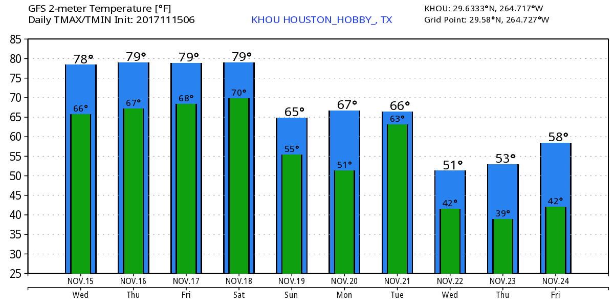
Houston’s weather will gradually warm up to end the work week, with overnight lows rising from about 60 degrees in the city on Wednesday morning to the upper 60s by Saturday morning. Mornings will see at least some patchy fog due to muggy air and near dead calm winds. High temperatures will remain pegged at about 80 degrees, with partly to mostly sunny skies. Can’t entirely rule out a few light showers later this week, but I’d bet heavily against rain for most people.

Saturday
For most areas except far inland, Saturday will be another warm day with highs around 80 degrees before a front moves through. At this point I’d guess the front reaches the northwest part of the area sometime around noon or a few hours thereafter, moves through the city during the afternoon hours, and probably reaches the coast sometime during the evening. But don’t hold me to that exact timing. I expect a broken line of showers to accompany the front, but don’t anticipate any kind of significant accumulations. Either way, lows on Saturday night should fall quickly, with inland areas seeing upper 40s, and coastal areas dropping into the upper 50s.
Sunday and Monday
Pleasant fall weather will prevail, with highs in the upper 60s, cool nights in the upper 40s to 50s, and sunny skies.
Thanksgiving week
Confidence is increasing—although we’re still a week out—in the arrival of another front sometime during the middle of Thanksgiving week. But when? Right now, the GFS model pegs it on Tuesday night or Wednesday morning, and the European model brings it through roughly around Wednesday evening. Both models also bring at least a little precipitation with the front, so the timing here is pretty key.
Given the uncertainty in timing, right now I’d guess that the region will see some rain showers on Tuesday and/or Wednesday, and we can’t rule out some thunderstorms with the front’s passage. I don’t think this will prove too disruptive for travel purposes. I’m cautiously optimistic that Thanksgiving will be at least partly sunny along with cooler weather. We might see high temperatures somewhere between 50 and 65 degrees. I’m more confident in temperatures at this point than I am in the clearing skies, and remain a bit concerned that some rainfall may linger into at least Thanksgiving morning. We’ll see!
It’s about time. The A/C actually ran last evening. In November.
One day heat, one day A/C. Time to be able to leave some windows open with neither running! This “Summer Stuff” already is very old and unwanted!
Its like you are the Thanksgiving Fairy with this forecast! Thank you for all of the hard work that ya’ll do. We are thankful for Space City Weather!
In case y’all hasn’t seen this yet:
https://youtu.be/h1eRp0EGOmE
I’ve not seen quite this much of a discrepancy before. That temperature profile you’ve got for next week is about 7-10 degrees lower each day than several other weather sites I’ve looked at this morning. It will be interesting to see how Thanksgiving actually plays out.