We have seen very heavy rainfall develop along and northwest of Interstate 69 this evening. Areas near the Addicks and Barker reservoirs have been especially hard hit, some of which have received 5 inches of rain since 6-9pm. Water levels in the reservoirs are rising, but still well below flood level as of 8:45pm CT. With flood warnings issued, and street flooding occurring across much of west, northwest, and north Houston this evening, travel should cease for the night. It is time to hunker down.
As for the rest of the night, we expect this mass of rains to the northwest of I-69 to hold together until around 10pm or 11pm, after which time it should begin to sag slowly to the southeast. After this time we expect most of the action to occur more close to the coast, on the southeastern side of I-69. In addition to this sagging mass of showers, another complex of storms will move up from South Texas, likely reinforcing the already existing coastal showers.

Given the totals we’ve seen so far, widespread totals of 4 to 8 inches seem possible for areas northwest of Houston tonight, with higher isolated totals. Elsewhere, totals are likely to be closer to 1 to 4 inches of rain, with isolated areas of 8 inches possible later tonight.
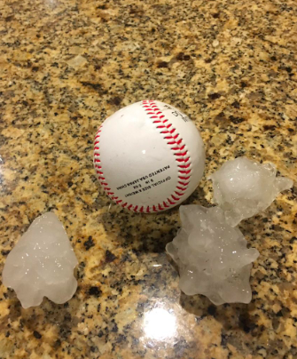
In addition to the heavy rains, we are seeing reports of hail, up to 2 inches in diameter, across much of the area. This will continue for the next couple of hours, and we may also see the potential for damaging straight-line winds later tonight. An unpleasant night, for sure.

Storms will eventually exit to the east, with rains likely ending across the area from 6 to 10am on Friday morning, from west to east. Then we can probably expect another wet night Friday night, although hopefully not as extreme.

It’s just now starting in Midtown as you posted this update. No hail yet, but I’m fearful for the plants and cars.
And, like usual, you were bang on with the earlier warnings about not being out after 7. It looked like the storms appeared from nowhere on radar a bit before 7, and look at it now. I guess those high-rez models were a bit more reliable this time?
Well said. Nothing there as we went out to eat at 5:30. Then at 6:45, our phones begin to “blow up” and radar “came alive”…
Sane here. Decided to go for a Costco run, even after looking at the radar and seeing a small line of showers. When we came out of Costco it was a monsoon!
Just starting in Ellington, not two minutes after I got home from the gym (talk about timing).
Last hour – WOW!! – lightning out the wazoo, 3 nearby hits, power off 4-5 times, alarm system triggered. Finally calming down last five minutes. Looks like just shy of 5” in the rain gauge (for the day).
Thank you Eric Berger For your great weather updates! Facebook group Houston Flood 2015 & beyond would love you to share your updates with the 8K peeps. Stay safe!
Oh my goodness the sound of the pounding rain and hails has my dear Fulgencio in tears tonight! I continue to comfort him with your reassuring words. Blessings to all tonight and be safe friends!
Any thoughts on tornadoes? Trying to decide if I need to bring the babies down with me for the night, my husband is out of town.
Better safe than sorry. Bring those babies down.
Yes, I am wondering about that for same reason too.
Any thoughts about bayou or river flooding Friday or on the weekend?
Thank you both for all your hard work and long hours you put into this. Truly a public service-
Not to mention how accurate your forecast are.
Again your work is greatly appreciated.
My wife is determined to drive to Shenandoah, TX from Dallas tomorrow afternoon. Hopefully I-45 will be OK.
Climate change is no longer a far off event, it is here and it’s only going to get worse.
Hi Eric,
I am wondering about tornadoes too. I am bit concerned for the kiddos, dad is out of town.
Thank you for your updates and for your time.
Be safe.
Can you explain the type of lightening that’s occurring with this rain? It’s like a constant strobe light; it never lets up! And it doesn’t necessarily follow with thunder. Why is it like that?
First significant wave moved through Galveston Island. Pea to dime-sized hail observed along with hard rain and high winds. Stay safe folks.
Thank you for your precise reporting and clarity in writing style. I have read this for over a year but don’t like to make comments. Just know that I appreciate this as do the people I have recommended this to over the year. You are truly gifted writers and researchers.
Hi… My name is Ramazan Recber I live in Adana, Turkey. I like this post, I wish you success in your work. please visit my website https://adanaklimaservisi.video.blog/