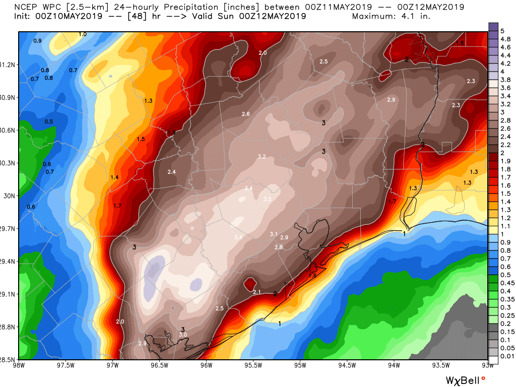
Good morning. We hope everyone is safe and doing well this morning. It has been a rough 12 hours in Houston and the surrounding area. From hail to non-stop lightning to flooding, I think we have all had enough. Numerous schools are closed this morning, including Houston ISD. Total rainfall over the last 24 hours has ranged from anywhere between 1 and about 7 inches across the region. On average, most places did 2 to 5 inches or so.
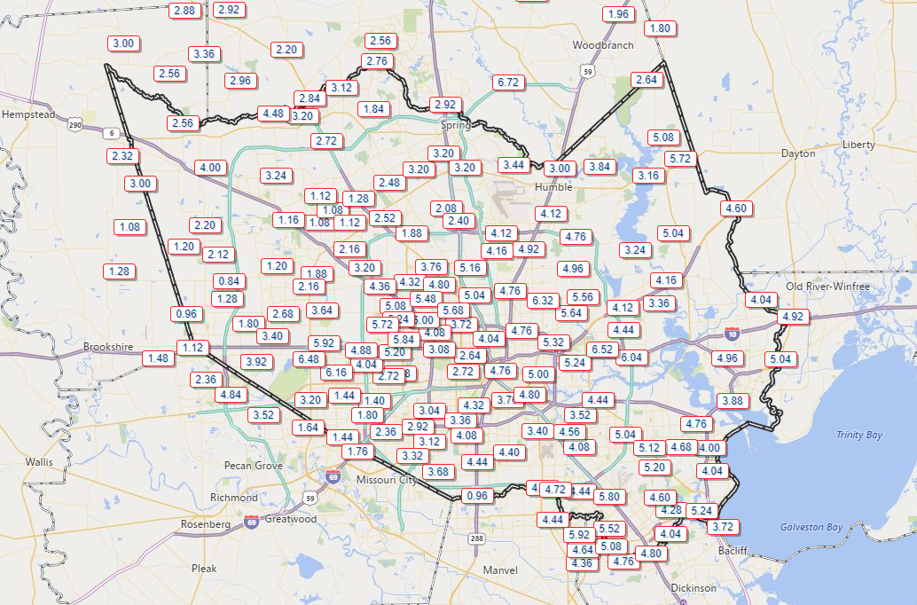
Flooding update
There are still numerous spots around the city and suburbs dealing with high water and street flooding. An areal flooding warning is in effect for almost the entire metro area through 10:30 AM.
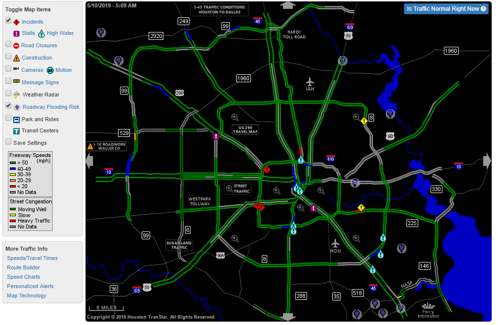
There were still a number of bayous that were either near bankfull or out of their banks. Most were southeast of the city, particularly along Clear Creek which is experiencing minor flooding between Pearland and Clear Lake. Spring Creek to the northwest is still rising a bit and is out of its banks at Hegar Road, as is Little Cypress Creek at Becker Road. Armand and Hunting Bayous have crested and will continue to slowly fall. Halls Bayou has as well, but that I-45 area near Mt. Houston is still a mess.
Trucks going the wrong way on I-45 feeder just trying to get thru the flood. Not sure why? #abc13 https://t.co/9BScHTxDNs pic.twitter.com/ctibnPN3ej
— Courtney Fischer (@CourtneyABC13) May 10, 2019
You can view the latest status of bayous and creeks at the Harris County Flood Control website. On the upper left, just check the dial for “Channel Status.”
In terms of the larger rivers: The West Fork of the San Jacinto is rising at US-59 near Humble.
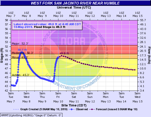
It will probably crest later today around a foot lower than we saw on Tuesday.
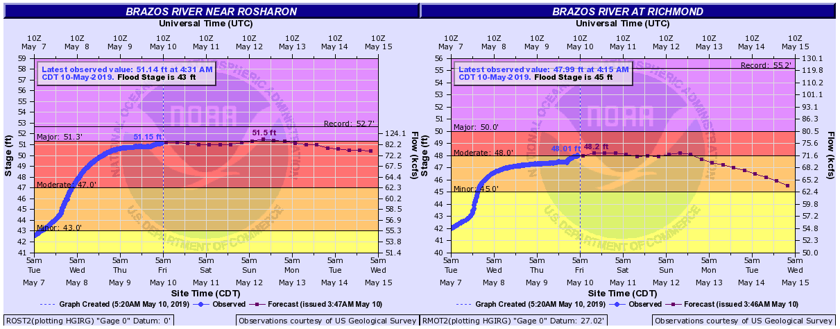
The Brazos will experience moderate to major flooding and is going to crest later this weekend about one foot or so shy of record levels at Rosharon. It will crest sometime today or into the weekend slightly less impressively, but still in solid moderate flood at Richmond. And it is going to stay high for a good time to come.
The bottom line: Be cautious this morning if you are out and about as there are a number of locations still flooding. But in general, conditions should slowly improve through the day.
This morning
Alright, let’s get into the forecast.
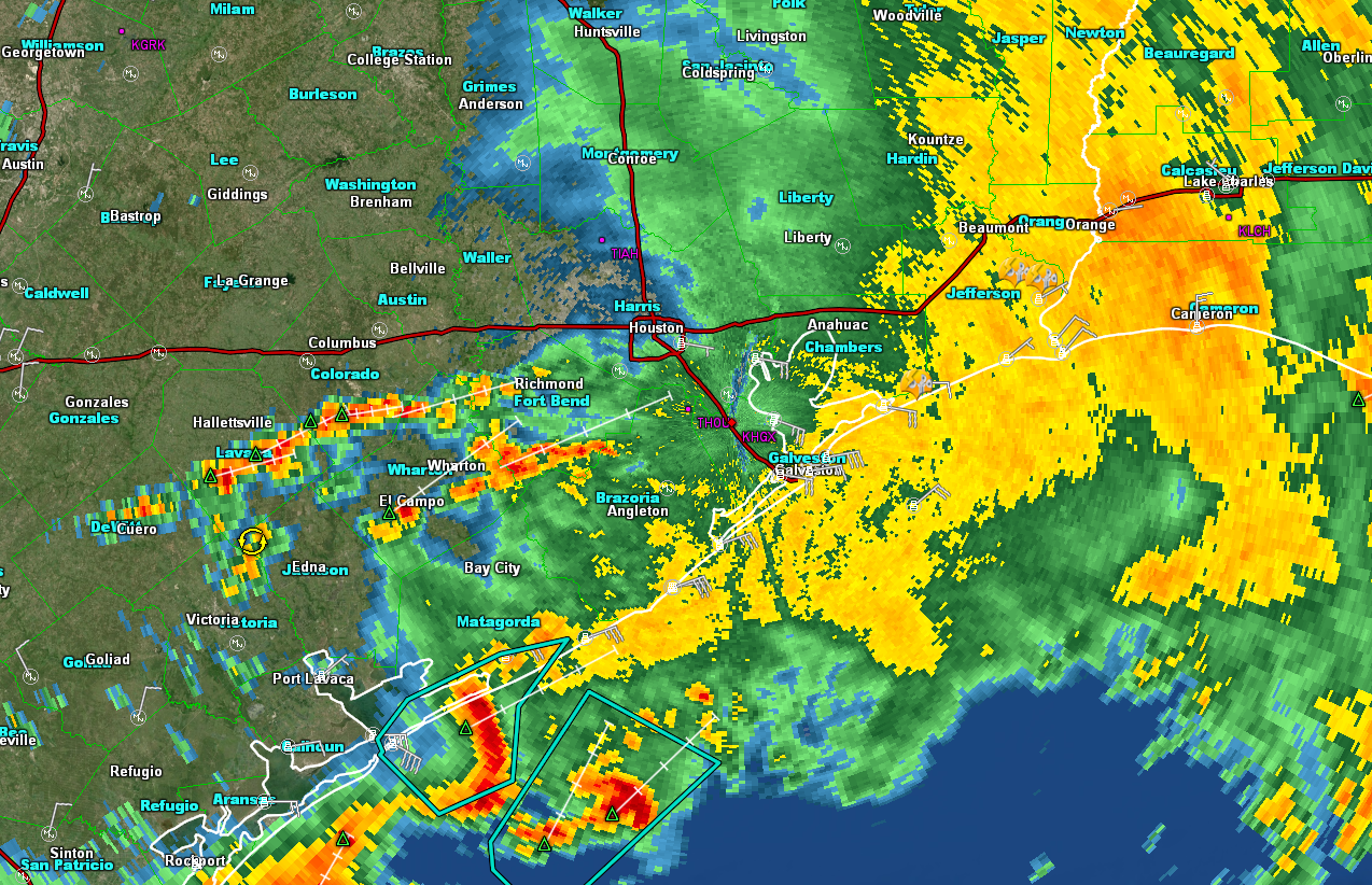
Radar as of 5:35 shows that the majority of the rain has shifted well east of the area. We are seeing new showers develop to the west and south of Houston. This isn’t unexpected, but it may mean some additional downpours over the next few hours, particularly along and southeast of US-59 from Victoria through Houston. There has been flash flooding in Galveston
These showers should gradually diminish and shift off to the east through the morning. There is simply very little “energy” left in the atmosphere over us to sustain new storm development. We’re tapped out after last night. So the trend should continue to be toward a drying one this morning.
This afternoon
Other than a handful of scattered showers in parts of the area, the rest of today looks quiet. We will have a chance to dry out a bit and clean up any mess left behind.

Tonight into Saturday
While the evening will likely start off quietly, things should begin to change during the 8-10 PM timeframe. Right out of the gate, let me be up front: We don’t foresee a repeat of what happened last night across the Houston area. That being said, we do think after that 8-10 PM window, the chances of potentially heavy rain increase. Look for scattered thunderstorms to pop up, especially after midnight and heading into Saturday morning. Rains will again be potentially heavy at times.
When the showers and storms taper off Saturday afternoon or evening, an additional 1 to 3 inches of rain will be possible. Some higher amounts can’t be entirely ruled out, but rain totals should be a little more under control here than they have been. Still, given that the ground is saturated, this will likely convert almost entirely to runoff as it falls. So flooding may again be an issue for some parts of the area.
The good news is that the rain should begin to wind down Saturday evening and clear out.
Sunday and beyond
We look to have a nice 3-day stretch of weather from Sunday through Tuesday. High temperatures should be in the low-80s, with low temperatures in the mid-60s on average. Some outlying locations may be able to sneak into the low-60s or even upper-50s on Monday morning. All three days should be partly to mostly sunny, with our next rain chance perhaps kicking in by Wednesday.
Eric will have an update for you later today to freshen up for tonight’s rain.
Man, that was some crazy-ass lightning last night here in League City, especially between 10pm and about 1am. I can’t recall ever seeing quite so much of it at once—it was almost like daytime.
Same here around Ellington. Another 1.7″ since 11 PMish so a total of 6.5″ for the last 24 hours.
No sleep at our house for several hours in Clear Lake. The clap of thunder a few minutes ago (about 6:15 am) made the dog jump into my lap! Precinct 8 Constable said it was hard for their people to get around due to high water. Going to work late (after full daylight). Turn around don’t drown! Or better yet, do not go if you don’t have to.
I’m working from home today (west side). No reason to drive.
We had the same freakish lightning up here near Jersey Village. It was constant flashing across the whole sky for hours.
I just want to say thank you, Matt and Eric, for all that you do. Keep up the good work!
Thanks for the update, Matt. That was one crazy storm last night–our rain gauge near Dairy Ashford and Buffalo Bayou picked up nearly 8″ just from 6 to 9 PM, and about 3″ more since then. Today’s drying-out time will be most welcome.
Thanks for the regular updates. School’s out for the day, which is just as well – don’t think we had the best night with all that weather crashing around! And the thunder and lightning is still going in Pearland!
3.91 inches in rain gauge in Katy,,,99 and Westpark tollway area…..
Thank you Matt and Eric for everything so far and through the next days. A fitful night here with the thunders and the tears of my dear Fulgencio, but we are here and excited for what Friday brings in life even if it is more of the rains. Blessings to all and hope all are safe!
No one cares about Fulgencio.
no need to be nasty
I do!
I do. I read every comment section hoping to hear that dear Fulgencio is doing okay and not collapsing into hysterics at the first clap of distant thunder.
Wow, heartless. Armando and Fulgencio you are in my thoughts.Stay safe please.
Where was Armando and Fulgencio during this Barry event? Wishing you both well & we missed you!!
Did thunderstorms used to last for 5 or 6 hours at a stretch? It seems like they go on for much longer periods of time than they used to. Is it my imagination or what?
I’ve been saying this for the past six years. I remember growing up in Galena Park when we’d get an afternoon rainstorm that might last anywhere between 15-30 minutes and then the weather would go more or less back to normal. There were occasional storms that dumped enough rain to flood Holland Ave. but most rain events were just afternoon thunderstorms. Here lately, it seems like every time rain is forecast, it lasts all day or is part of a multi-day rain event. It’s nuts.
I think I’d just about gotten to sleep when HISD simultaneously called my landline, my cell, sent me a text and an e-mail at 4:30 to let me know classes were cancelled.
Thanks Matt!
We are as usual very grateful for your work, Matt and Eric! The Houston area is blessed to have you both.
Yes and amen to this wonderful site. Thanks for all that you do, Eric and Matt. Like many patrons on this site have mentioned, this too is my “Go To” weather source.
Thanks again guys for your time and effort. It makes a difference to many of us!
Good work all around by the team at Space City and, really, all the forecasters. 2 to 7 inches was the general forecast before the event and that’s about what happened. It was quite a light show and some very impressive hail pix on Twitter last night.
Every time one of the local stations run their models, it looks like almost nothing materializes, but it doesn’t stop them from selling it. Thanks for the honesty. I’m prepared for the worst, but I’m resting easy as the district gave us a day off.
Excellent forecast!! I really appreciate the straight story with no drama, just the data.
3.25″ in my rain gauge this morning. I am just off BW 8 North between 249 and 290. Tons of lightning and thunder, seemingly all night long.
Thank you Matt and Eric!!
It’s amazing how variable the rain rates were with this storm, I only had 1.9 inches on my automated rain garage, I bet a mile south (in the reservoir) it was probably 5+.
Received around 5 inches in about 2.5 hours(6″ total overnight), along with 1.5+” hail off of Kempwood and Belt 8. My street flooded more than it did during Harvey. Sounded like bowling balls being tossed on the roof for about 5 mins, but felt like an eternity. Time for a new roof…: (
We are leaving on a mission trip and are supposed to be at Bush by 6:15 Sat morning Coming from Sugar Land. You think it will be possible ?
In Deer Park, we must have had some “almost tornadic like winds”. An established tree snapped about 2 feet from the ground, lawn furniture broken and across the yard, 3 established shrubs down and limbs down. All this in our backyard. The front yard is completely untouched. We had over 5 inches of rain and hail. Still no electricity. What a storm!
Yes – great job Matt and Eric as always. The talking heads on tv are just looking for ratings it seems. Maybe there could be a role switch: You two handle the heavy, weather related forecasting and THEY get to deal out the personalized and individualized weather forecast street by street mixed in with basic life-living advice.