Good morning. A day after historic flooding in Houston the radar is quiet. We also got good news last night when showers over central Texas broke mostly apart before reaching the Houston region. As we clean up today, will Mother Nature continue to cooperate?
TODAY
A flash flood watch remains in effect through Wednesday morning for the entire Houston metro area.
I think things will remain quiet this morning, but we’re still seeing moisture flow in from the Gulf of Mexico, and mechanisms remain to lift that moist air. My guess is that we’ll see development of spotty showers later this morning or early afternoon along the coast, and possibly more organized activity to the east of Houston, which is good because these areas were hit least hard on Sunday night and Monday. Some scattered showers could move inland into central and western Houston later this afternoon.
The big concern will be storms that produce rainfall rates of 1 to 2 inches per hour, that would fill bayous back up quickly. However at this time I don’t think we’ll see those kinds of rains today over the western part of Harris County, Montgomery County, Waller County and other areas that were hammered. If that changes I will let you know.
WEDNESDAY
Some forecast models show a more organized system of showers and thunderstorms moving into Houston late Tuesday and on Wednesday morning. (Others do not). What concerns me about the potential for this system is that it could have fairly high precipitable water levels to work with.
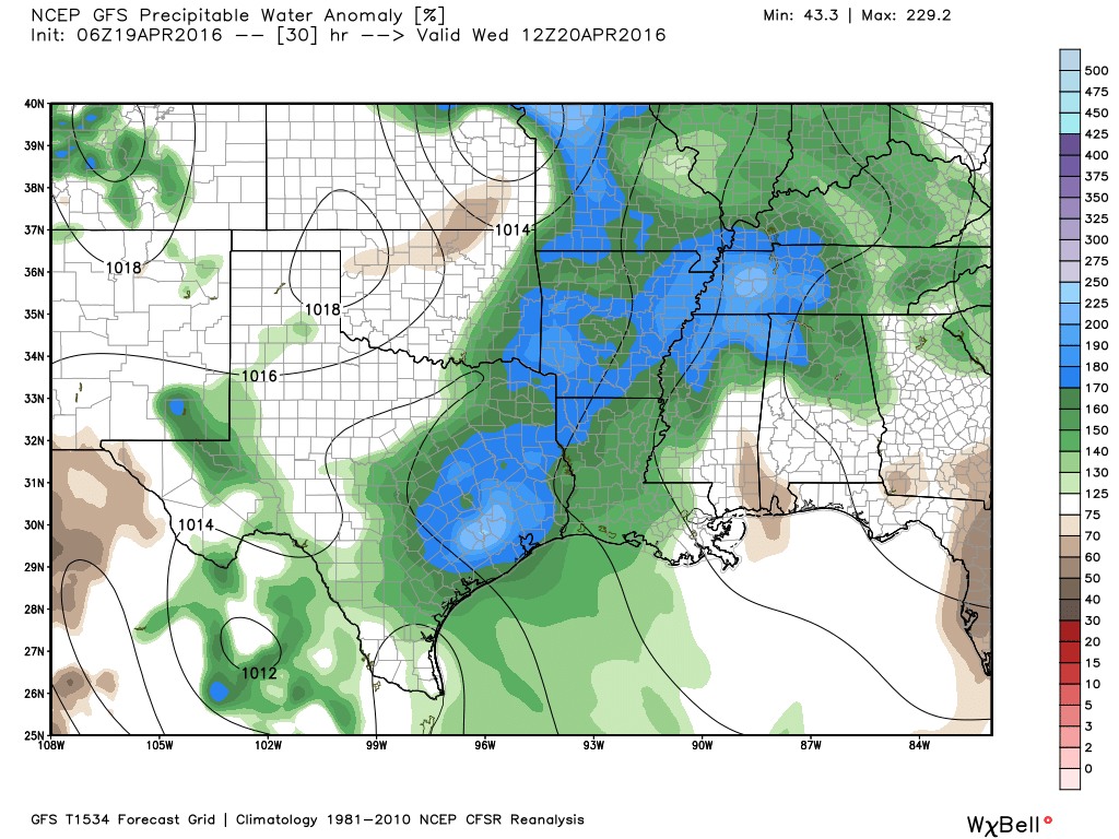
That means the atmosphere will again be quite moist, and capable of producing heavy rain. In my view this probably represents the best chance of organized shower activity in the Houston region. However, there’s a lot of uncertainty but we’re going to have to watch for this to occur.
THURSDAY
Another day of potentially unsettled weather, with high moisture and enough lift in the atmosphere to cause us some problems with locally heavy rainfall.
The bottom line for the next three days is that we’ve got the right ingredients for heavy rainfall, but they’re not quite as focused as they were on Sunday night. So while we might pick up another 1 to 4 inches of rainfall, with a few areas getting more than that, I don’t think we’re going to see the kinds of explosive rains that we just experienced. I’m not ruling that out, and we’ll be watching for that, but I don’t want to alarm anyone either.
FRIDAY
A cool front arrives Friday to bring us some sunshine for most of the weekend, an end to the rain, and slightly cooler nights.
Posted at 6:45am CT Tuesday
Thank you for the update!
Thanks, Eric. As always, I come to you first for the weather.
Awesome Job Eric! Many thanks for your work.
Thanks…I am so happy to find your blog after your departure from the Chron!
A big shout out to Eric for his incredibly measured and to-the-point analysis and to everyone in charge of the Harris County flood warning system http://www.harriscountyfws.org/ A really nice resource, in times you need it most.
I am so happy that I discovered your website and subscribed to your Space City Weather reports! I have always enjoyed your manner in explaining the weather details and prefer to hear your thoughts on the subject. Especially this week with such widespread horrendous weather inundating us! I appreciate your timely updates each day that have been so comforting in putting my fears at rest and I thank you so much for your caring thoughtfulness. I have 6 fabulous grown children-5 daughters who call me at least once a day, and one son. He is with a Maritime Co. in west Seattle, not far from the airport and keeps watch on our Gulf weather. I always spread word of Space City Weather to everyone I know! Wishing you a safe and beautiful day, Marilyn L. Flaherty
Marilyn, glad you found me! And thanks for spreading the word.
Why is everybody saying this is a 200 year event? I mean didn’t the Houston region see this on Memorial Day too? I understand we get this stuff with TS and Hurricanes and such but was looking for explanation why this is a 200 year event. Thanks Eric for the updates.
It may have to do with how widespread this one was. Memorial Day last year was bad for those who got the punch, but it seemed localized – we only got an inch or two at our place. This seems to have been much more widespread.
Good question Jeff. I agree – with Allison 15 years ago, Memorial Day floods last year and this, why are these 200 year floods? Seems like 5 year stuff.
Ok, so the important thing to remember with a 500-year flood is that it is location specific. So you can have a 200-year flood for a particular location in Harris County, but 5 miles away, where 5 fewer inches of rain fell, it might just be a 10-year rain. Does that make sense?
sadly no but hey I am older and my mind doesn’t work as good these days…lol. But in all seriousness, kinda. So they are saying those parts at Greenspoint and such is the 200 year flood?
I need to decide between flying out of Hobby either tomorrow early afternoon, or Thursday mid-morning. Which of those time periods is looking more likely to create a situation of major delays and/or cancellations? Thanks for everything!
I would rate tomorrow early afternoon as more potentially problematic than Thursday.
Great. Like the reader above me, glad to be able to read your take on the weather again after you left the Chronicle. Thanks!!
So how does the precipitable water estimated for tomorrow morning compare to, say, Monday morning?
When will the next update be concerning the possibility of afternoon/evening showers? My husband went into work and I want to make sure he can make it back before the weather turns worse.
Thanks for providing a calm place to read about the weather. Anxiety sufferers really appreciate this site.
What is meant by air moisture. I see most of the map is white at “75”..
Is this what would be typical, and anything less would be considerred dry?
White is normal, ie, 75 to 125 percent of normal precipitable water, a measurement of total water in the column of atmosphere between the surface and outer space. Higher totals mean there is more moisture to be wrung out of the atmosphere in the form of rain.
Hi Eric, thanks for all the information! This has been so helpful to our family. We live off Louetta and 249 and there’s quite a bit of flooding in the NW area of Cypresswood in spring. Do you foresee more rain for this area today?
Forecast from earlier today seems to be holding up well — chance of spotty showers, should not be anything too well organized.
Do you know if Mayde creek has crested? Really need to get to work in the morning.
Looks to be slowly receding. http://www.harriscountyfws.org/GageDetail/Index/2190