Summary: In today’s post I discuss the bluebonnet season, and look ahead to warmer weather and a likely wet weekend. If you have outdoor plans, you’ll definitely want to keep tabs on the potential for precipitation.
Texas bluebonnets
I wanted to say a quick word about wildflowers in general, and bluebonnets in particular. If you’ve driven between Houston and Austin of late you know they’re spectacular. The combination of a very hot summer last year, which thinned out wildflower competition, and a relatively wet winter created near ideal conditions for this bluebonnet season. “On a scale from one to 10, this year looks like it could be an eight, for bluebonnets in particular, if not even better,” said Andrea DeLong-Amaya, of the Lady Bird Johnson Wildflower Center, in a forecast a few weeks ago.


A reader of Space City Weather, Niloeby Montenoeci, was kind enough to share a few photos taken of late. We are right about at peak season right now, so be sure and check these lovely flowers out.
Tuesday
It took awhile for skies to clear on Monday, but when they did conditions were lovely across the Houston metro area. Today will be a little more humid, a little warmer, and a little more cloudy. We can expect highs in the upper 70s this afternoon, with partly to mostly cloudy skies, and light southerly winds. This is the beginning of moisture return that should eventually set the stage for some healthy rain chances later this week.

Rodeo forecast
There should be nothing but fine weather for this evening’s show, with temperatures in the low 70s this evening and partly to mostly cloudy skies. Winds will be about 10 mph, so nothing crazy there. Afterwards conditions will be mild, with temperatures in the upper 60s. Lows tonight won’t fall much further, perhaps dropping only into the mid-60s overnight in Houston. Some fog may develop late tonight into Wednesday morning.
Wednesday
This will be a warmer day, with partly to mostly cloudy skies, and highs in the low 80s. Lows will only drop to around 70 degrees.
Thursday
A warm day, with highs in the mid-80s and fairly humid air. Some light rain showers are possible, but the overall chances are fairly low due to a capping inversion. If the cap breaks, we may see some thunderstorms later Thursday or into Friday ahead of a cool front.
Friday, Saturday, and Sunday
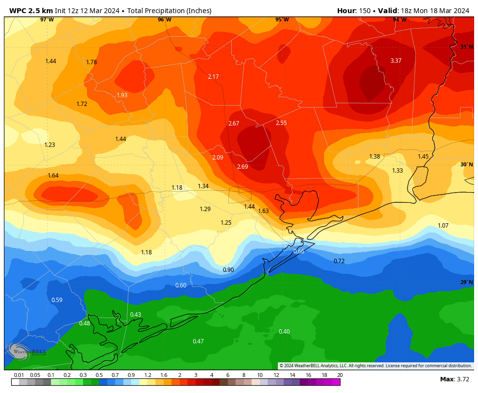
This initial front is likely to move into Houston and more or less stall near the coast. This means we’ll have a fair amount of moisture in the atmosphere and unstable conditions—a good starting point for rain showers. Daily chances are about 50 percent on Friday, Saturday, and Sunday, with total accumulations likely of 1 to 2 inches for most of the area. I don’t think this will be a total washout, but if you have plans for the weekend you’ll definitely want to keep tabs on the radar.
In terms of temperatures, we’ll see highs in the 80s on Friday, followed by 70s this weekend for the most part. A secondary push should shove the front offshore some time on Sunday or Sunday night, setting the stage for a cooler start to next week. Lows on Sunday night could drop into the 50s.
Next week
We should begin week in the 60s, with nighttime lows in the 40s or 50s, and some sunny weather. We’ll warm back up some by mid-week, when rain chances resume.

I’m sure the CAP that we now seem to permanently have over Houston will keep this rain away from us. Just seems to be a new part of climate change.
The capping inversion effect actually has been part of our Houston weather for a long time; as I understand it, this is largely due to the effect of being an extremely large city with vast reaches of concrete. This heat sink often affects how weather systems interact with us.
This is how I have been thinking of it; please school me if wrong @spacecitywesther!
There is no question that Houston being more concrete that green space creates its own weather patterns, and as the greater Houston bio space spreads further into the country covering more fields with concrete, this pattern is going to loom much larger in our futures. Anyone with the freedom to escape this awful mass, is very fortunate indeed.
One of the main drivers of our atmospheric cap is the hot dry desert mountain plateau in Mexico. This hot dry air from this region often times gets pulled into southeast Texas ahead of our cold fronts. This layer of hot dry air in the mid levels of our atmosphere often prevents the warm humid unstable air at the surface from rising once it hits this warm dry air. Air needs to cool more with height in order for the warm moist air at the surface to continue rising high enough to where it can condense into water droplets aka rain. When the surface winds blow directly from the Gulf into incoming cold fronts, that greatly increases of getting storms in our region. This phenomenon is nothing new and has been a contributor to many droughts in Texas history. Climate Change could possibly make the cap stronger at times, but the cap itself has existed as long as the geography of the North American continent has been set up like it is now.
Unless my study’s are wrong, the concrete should actually help boost lift over the city since the heated concrete from the sun will rise more effectively than the cooler land air. Right now, I think it is more the dry desert mountain air from Mexico intercepting the mid levels of our atmosphere ahead of the cold fronts. This is why far East Texas and Louisiana typically get more rain Annually than the Houton area. This cap from the desert southwest doesn’t affect these areas as much during the fall, winter, and spring. Our region lies in that mid zone between the dry desert air and the wet gulf air. Sometimes the dry desert air wins the battle and other times the wet gulf air wins. It depends strongly on the position of the jet stream winds. The subtropical high that sets up during the summer can also cap our atmosphere because the hot air that rises from the equator cools and sinks over the midlatitudes during the summer months. This sinking air prevents the hot humid air at the surface from rising high enough to create showers and thunderstorms alot of the time. It amazes me how the simple geography of one place can affect the weather of another area so far away.
The picture of the deer in the bluebonnets is probably the most gorgeous picture of our state flower that I have ever seen!!
I was thinking the same thing 😊
Hopefully this intermittent warm and cold weather will disrupt the June Bugs swarms and lessen the overall numbers… but we’ve got the 13 and 17 year cicadas coming out this summer too.
Our backyard is covered in bluebonnets and we love it! I am not a fan of the warmer weather though…keep it cold!
Good write up on capping inversions here. Hopefully folks bookmark for the next time SCW says “we’re capped” ….it will be on Friday, I bet. Cloudy like today but noooo, no rain for you! It’s when the cap breaks that things get very interesting.