One front is through the region, and now we wait for the big dog front later in the weekend. First, we do have some wind to get through today.
Today
With the front to our east now, changes will be afoot today. We barely dropped below 70 (!) overnight, but we just crept into the 60s as I write this, and by the time you read it, it may be in the 50s. It will be a chilly one by mid to late morning. We’ll hold near or just above 50 for the majority of the afternoon. But it will be the wind that’s the real story today. Wind Advisories are posted, and we can expect wind gusts of 30 to 35 mph in Houston, and into the 40s over the bays and along the coast.
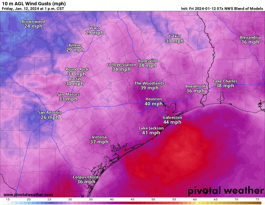
Winds will subside toward sunset, with a quieter night ahead. Look for lows tonight in the 30s in much of the area away from the coast. A light freeze will be possible north of the city and in some of the more sheltered areas south, west, or east as well. Temps should not be any colder than we’ve already seen this winter.
Saturday
A fine day. Highs should be around 60 or in the lower-60s. A great day to finish your winterization preparations. And go Texans!
User’s guide to the Arctic cold
With our two posts per day now, we are aiming to update with each main cycle of model data that we are able to see. So there should be fewer big changes with each post. I’m going to change up this post a bit to sort of hit on the key points rather than give a chronological forecast. Here’s what we know.
Key messages
- Front hits Sunday morning ushering in cold (most areas well above freezing)
- Temps in the 30s to near 40 with an east or northeast 10 to 15 mph wind for the Houston Marathon.
- Light precipitation likely Monday and light icing on area roads is possible, especially north and west of Houston. Tuesday AM commute may be impacted in spots.
- Temperatures may stay at or below freezing much of the time Monday morning through Wednesday morning.
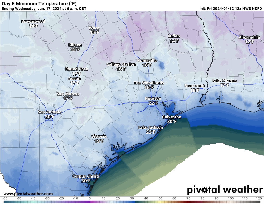
- Hard freeze temperatures (less than 25 degrees) would likely last 8 to 10 hours at a time in Houston on Monday night and Tuesday night.
- Wind chills will be as cold as 10 degrees or lower on Tuesday and in the teens much of Tuesday and Wednesday morning.
- We warm well above freezing on Wednesday, with highs near 60 by Thursday.
When does it start?
We need to think of this in two ways: When does it get generically cold and when do we see freezing temperatures? The answer to “when does it get generically cold” is coming into focus. The front looks to hit probably Sunday right around sunrise now. Temperatures in the 40s will probably drop back into the 30s as the front hits, with a light freeze possible north of about The Woodlands on Sunday morning.
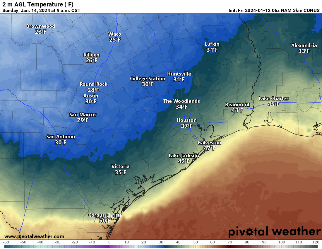
The rest of Sunday would be cold but dry with temps in the 30s. A widespread light to moderate freeze is possible Sunday night into Monday morning. A more consequential freeze is possible Monday night into Tuesday morning, with temperatures in the 20s probably everywhere but at the coast, struggling to get above freezing on Tuesday afternoon. And then the coldest on Tuesday night into Wednesday morning. Thankfully, we should bounce back well into the 40s on Wednesday afternoon.
This obviously brings up a couple additional questions.
How bad is the Houston Marathon going to be?
The answer to that question depends on your preference I suppose. I would expect temperatures perhaps dropping as runners are in motion. We may start in the 40s and drop into the 30s or start in the 30s and hold steady throughout. The wind? It doesn’t look horrific, but it doesn’t look great either. We expect northeast to east winds of 10 to 15 mph or so. There will certainly be some gusts near 20 mph at times in there as well. The more meaningful wind should thankfully hold off until Monday or Tuesday.
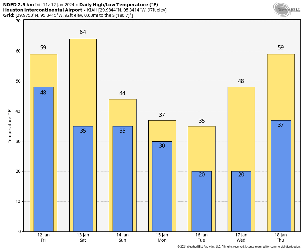
How cold will it get and for how long?
You can see the chart above for IAH. Let’s answer a few different questions. In Houston, the absolute worst case scenario right now would be temperatures dropping below freezing on Monday morning and staying there through Wednesday morning. Bear in mind that these would be temperatures more in the low-30s Monday (instead of the low to mid-20s like we saw during the February 2021 freeze). A more reasonable scenario is that we poke above freezing for a bit on Monday, then drop back Monday night and stay there into Wednesday morning. The coldest stretches (temperatures of 25 degrees or colder) will probably be limited to 8 to 10 hours at a time Tuesday and Wednesday mornings.
With gusty winds likely on Monday and especially Tuesday, look for wind chill values to drop into the teens much of the time, and at least for a time perhaps in the single digits. This is dangerous cold for pets and people outside, so please make sure to bring in the pets and check on anyone vulnerable to cold exposure.
Will there be wintry precipitation?
A disturbance passing over top of the cold air looks likely on Monday now. This will likely produce 12 to 24 hours of light precipitation across the area. With temperatures hovering near freezing, yes, that means we could see some freezing drizzle or light freezing rain as that precipitation moves through. There’s good news and bad news here. The good news is that amounts look light. So this isn’t going to be an all-out ice storm with lots of power outages due to ice buildup.
The bad news is that any amount of ice can make travel difficult. Monday is a holiday so there will be fewer people on the road already. That’s good news, but if for whatever reason you have to go out on Monday, please check on area roads before you leave. DriveTexas.org is a good resource to have. The Houston TranStar website will show you areas of ice. While there is still uncertainty on exactly how cold it will be Monday, it will be close enough to freezing to think that at least patchy ice will be possible on area roads, especially north and west of Houston and on freeway flyovers.
We don’t want to get into the prediction of traffic or school closures, but yes, you will want to pay attention to how things evolve this weekend for going to back to school or work on Tuesday, as Monday’s conditions could directly impact Tuesday’s commute too.
Will my flight be impacted?
We don’t predict airline behavior here, but yes, probably at some point Bush and Hobby will have some issues, but hopefully nothing major.
When does it end?
As you can see from the temperature forecast above, once we get above freezing on Wednesday morning, we are probably going to stay there into Thursday, with temperatures even near 60 degrees possible! Colder weather should come back next weekend, but it will likely be milder than we will see early next week. We will have more, including a broader look at Texas during this freeze event later today.


I went on my longest training run for the half marathon in Ohio during the holidays and it was 36 degrees. I definitely didn’t think it would prepare for the race temperature in Houston! I prefer cold running, so this forecast evolution has been wonderful to follow. Thank you for all of the updates!
All the best for the marathon! 🙂
I remember my winters growing up in Ohio well….you were lucky it was 36.
Same in Central NY! 🙂
Same in Chicago!!
Last year, I skipped the long run because the wind chills were -25. I remember those winters too!
Haha! We ran in Michigan during the holiday as well! It was 27 degrees. I’m ready! 🤣
I think you forgot the most important question “When will it get warm again?”. Looking at pictures of Chicago reminds me why I live in the great Houston.
Reminds me of how much I miss it up there.
Can you elaborate on the easterly winds during the marathon. That is the final 6 miles. And seems counterintuitive to a cold front.
I was born and raised in Green Bay. I find all this preparation for 5 days of chilly temps amusing in a way but again very much needed here as building codes for water lines are way different here. I no longer own a proper winter coat. Winter preparation was always a fall activity every year as temps would stay below zero for days or weeks at a time. Hang in there Houston and follow the advice of Space City Weather guys🥶🥶🥶
Building codes are lax here for both winter and tropical weather, all so builders can pocket and extra couple of bucks.
Thanks for the calm in depth insight. The local media will have everyone in a panic by Sunday night and school likely will be canceled on Tuesday for most districts whether or not we actually have any icing or not. Depending on how much fear they can stir up it may be cancelled for Monday as well.
Growing up here as a kid in the 1970’s we had more of these events and school was almost never cancelled. The difference now is the media and their desperate attempt to get views, clicks and likes…
HISD is already closed for the holiday on Monday
So true. Back “in the day”, HISD would grudgingly cancel school only when just about everyone else did so. Even then you’d go to bed not knowing for sure with announcement not coming until 6:00 or 6:30. A.M. But now they’ve gone too far – in OTHER direction!
You do realize Monday is a holiday Bill
Ah, yes – so I spend a couple of hours this weekend in the attic checking pipe insulation for squirrel damage and covering the gable vents with plastic sheeting. The small, cramped, long attic that I can’t stand up in…. and is full of flexible HVAC ducting…which is now huge since it is new and to current code….. I’m getting too old for this… ah… “stuff”.
Will Sunday be safe to travel to Austin during the day?
Will the winds on Mon/Tues be as gusty as today? Mph?
Oh I remember the old days. Had no idea what the temperatures were. Sit next to the gas space heater in our old 2 bedroom bungalow eating a hot cup of oatmeal preparing to walk to school in the cold. Ah, miss those simple days.
I assume that was after you brought the yaks in and fed them, collected the eggs, ploughed the back forty and let the sheep out in the front pasture?
Time to evacuate to Katy. LOL
Never heard of NE and East winds with an arctic front that dives from the north from the plains, but whatever. Experienced Texans who take it all in stride and know how to handle everything will be now-casting from Sunday on watching temperatures upstream and at location. 12-24 hrs of light precip with freezing temps… gonna cause problems.
A blue norther. You have lived in Texas for how long to be considered “experienced” and you don’t know what a blue norther is?
This would not be considered a blue norther because of the precipitation and clouds that are going to linger after the cold sets in. Blue northers refer to bluebird skies after the front and comes with northerly winds, not east/northeast.
Great info on the cold stuff! 🌬 ❄ ❄ ❄
Did anyone read the ENSO report that came out yesterday? Around a 62% chance of La Niña in Aug/Sep/Oct… maybe after the cold stuff, could we talk about that?
⚘ stay safe & warm everyone
Good luck in the marathon! One question: I have a fountain in an atrium. Should I drain it, or turn it off, or just let it run like normal? Thoughts anyone?
An option would be to put a fish tank heater in the water to keep it flowing through the freeze. Depends on a lot including how much ground contact and how much piping inside of the fountain you have.
Why not have thermowells in the pipes in out attics so you can monitor the water temperature with a wireless thermocouple?
I know, over-engineering it…..
I have company coming in from Austin this weekend and we’re trying to decide if they should shorten their stay and go back on Sunday as opposed to possible ice on 290 on Monday?
Roads should be fine Monday afternoon. There’s a slight chance of light icing during the morning commute. Thankfully Monday is a holiday for many folks.
I doubt temps will rise above freezing monday afternoon in Austin, so I would be careful.
Can you elaborate more on the freezing conditions and timeframes expected on Galveston Island?
So ready for this crappy weather wet, windy and cold weather to go away. Thanks for the info as usual!
Weather Underground forecast for Mon to Wed has no freezing rain and High temps above freezing for those days.
And please for the love of God bring in those innocent pets that depend on you.
Good luck with my Husky. He thinks “If I’m hot, they’re hot, bring them outside into the winter!”
Do the maps come to you pre-filled with city/area names? You’re missing a whole swath to the north and west, so no specific info for Katy, Jersey Village, Cypress, Tomball, for instance.
Thanks for the updat
I think the wind story was under reported today 12-Jan. I’m on the far west side of town and the wind kicked up today and roared between ~2AM until ~1PM. My local anemometer recorded 50mph gusts.