If you missed it on Sunday, we put together a summary of what has been a pretty wild June in terms of severe weather in the Houston area. Not everyone has participated, but many have. We discussed why and what has made forecasting these storms so challenging. This week? None of that. At least not through Friday we don’t think. It just looks torrid.
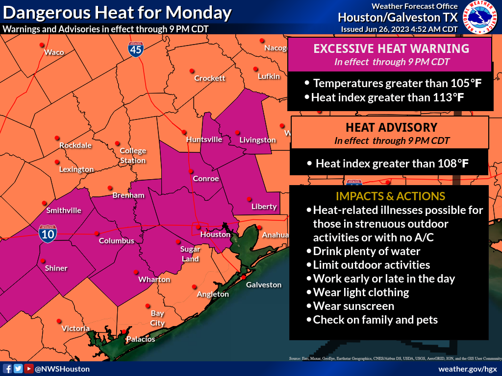
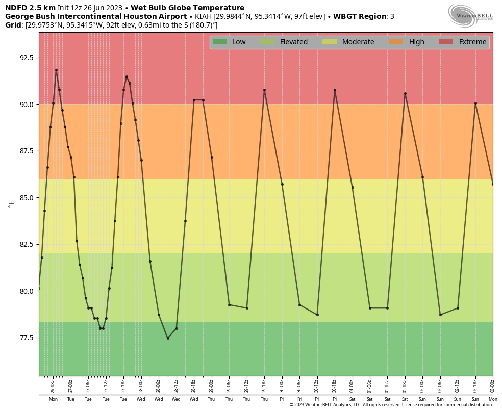
Once again, it will be important for all of us to practice maximum heat safety this week. Whatever index you use, it will feel terribly hot all week, with heat index values of 110 to 115 degrees and wet bulb globe temperatures in the “extreme” level for the human body. While the forecast temperatures will not be overly impressive, the combo of temperature and humidity remains abnormally potent for our area, the next level of heat.
Today through Thursday
High temperatures will scorch the next few days, generally in the 100 to 102 range. Overnight lows will be near 80. Humidity levels will be awful. Rain chances look to be near zero through Thursday. Yada yada yada.
Friday and Saturday
More of the same. I just wanted to break up the post a little.
Sunday and early next week: Relief?
So to the question you’re all wondering: When does this end? It appears more likely that by Sunday or Monday, the potent, relentless ridge over Texas and/or Mexico will finally break down. You can follow this on an upper level forecast map. Notice how you can clearly see the “dome” of high pressure over Texas. That finally begins to collapse on Sunday and Monday of the weekend/next week, and that should hopefully yield cooler temperatures and rain chances. Unless you have Fourth of July plans, in which case, of course.

But, we really need a period of cooler weather and hopefully some rain chances. We certainly hope the holiday is rain-free, but we’ll see.
Tropics
Nothing new or exciting to discuss. We’ve seen some noise on the operational modeling way out in fantasyland, much like we did earlier this month. But there is no real support for anything. Check our companion site, The Eyewall for a full tropical update for the Atlantic if you’re interested in more! And just a reminder, if a storm were to be a concern for Houston, we would still include all the relevant info here at Space City Weather. We’d love for you to read The Eyewall regularly, but you won’t be missing Houston-relevant info!


I am reading The Eyewall every time you publish. Love the hurricane and rough weather tracking. Good work, gentlemen.
Thank you!
thanks for a moment of levity! just to break it up, indeed!
It seems to my amateur observation that fewer hurricanes come to Houston during an El Niño period? More doughy-like conditions bite fewer hurricanes?
Not a secret really, since it’s known that El Nino derived westerlies in the tropics tend to provide more shear that’s not conducive to tropical storm/hurricane formation. But, anomalously high SSTs in the Atlantic may thwart this and any weakness in shear may allow a storm to slip through. A bit of tug-of-war this season.
Actually, El Niño tends to produce less drought. This summer is a bit like last summer in terms of heat, which was a La Niña summer. In terms of moisture, it’s not quite as dry as you’d see in a La Niña, but it’s definitely dry across some of the state. But the fewer hurricanes observation is correct. Historically, El Niño events have tended to produce fewer storms. So, that’s good but of course it just takes one bad week to ruin the whole season.
It always seems to rain on the 4th of July. I can remember many years on the glorious fourth, wondering if there would be fireworks because we had one of those spring/summer showers that spring up in late afternoon or early evening.
Doughty-like? DROUGHT-like!
I prefer rain on The Fourth Of July so people shooting off fireworks won’t set homes on fire. It happens.
People will still shoot off fireworks even with the risks you mention, sorry
Sadly, there is no restriction on idiocy.
Not at this point. Right now, our intent is to see if it actually works and can draw in the audience we’re hoping for. It’s more of an experiment than anything at this point. After next season we should have a good idea if it’s app-worthy!
Matt – Has there ever been a study to determine how many hydrogen bombs it would take to destroy a heat ridge like this? If it’s not more than 5 or 6, we should probably do it.
Just observation not critical: Global Wet Bulb looks like another black box measure like heat index. Standard wet bulb never got above 79 yesterday near downtown. 82+ can lead to heatstroke. Wet bulb is the lowest temperature you can get standing in a wet mist in the shade. Or a cooling tower. Like a restaurant shaded patio with misting devices.
WBGT is actually a pretty good measurement, as it factors in latitude (sun angle), wind, cloud cover, humidity, and temperature in the sun, not the shade. So it incorporates more. I don’t actually want people to focus on the number, but rather the level, which tells us how stressful it will be on the body. At extreme levels, that’s pretty stressful.
😂 “More of the same. I just wanted to break up the post a little.”
Yeah, a little humor to break the monotony of hell, goes a long way.
The website address looks like Th Eeyewall. Like Eeyore but Eeyewall. Oh yeah, also it’s hot outside.
Thanks for posting the link to yesterday’s [Sunday’s] explainer post.
IF it was sent out via email, it didn’t make my inbox like the daily reports always do.