Good morning. For much of the region, temperatures this morning have only dropped to 50 degrees, and the next two nights will be even warmer. However, by Thursday another front will reach the area, bringing sunnier and chilly weather for the weekend. Also, if you’re interested in an update on our app, see the bottom of this post.
Tuesday
Winds are light out of the southeast this morning, but they’ll pick up today as the onshore flow really gets pumping. Expect gusts to reach about 20 mph. This influx of moisture will lead to partly to mostly cloudy skies today, with highs reaching about 70 degrees. Lows tonight will only drop into the upper 50s to 60 degrees, with even warmer conditions right along the coast. Some light rain is possible near the coast late tonight.
Wednesday
The potential for light, scattered showers will continue on Wednesday morning, with the possible additional development of some fog near the coast. The day itself will be windy, with southerly gusts as high as 25 to 30 mph really amping up moisture levels. Highs on Wednesday will reach the mid-70s for much of the area, and with dewpoints in the 60s you will start to feel some humidity. Skies will be mostly cloudy, with a continue chance of light rain. Low temperatures on Wednesday night will only drop into the upper 60s, with a chance of scattered showers and perhaps a few thunderstorms.
Thursday
This day will start out muggy, ahead of the front. There is a chance of thunderstorms on Thursday morning. However, my sense is that the atmosphere will be capped enough that for most of us there will just be some fairly brief showers before the front reaches our northwest areas during the morning hours, the city around noon, and the coast during the afternoon hours. Highs ahead of the front will be in the 70s, with dewpoints and temperatures dropping after its passage. Skies will clear during the afternoon hours, allowing temperatures to drop into the upper 30s on Thursday night for all areas but the coast.
Friday, Saturday, and Sunday
We’ll see mostly sunny skies on Friday and Saturday in the wake of the front, with highs in the upper 50s for most areas on Friday, and lowers 60s on Saturday, probably. Sunday is a bit warmer, slotting somewhere in the 60s with rising dewpoints. The first half of next week should see highs in the 70s before the likely arrival of the next front.
App Update
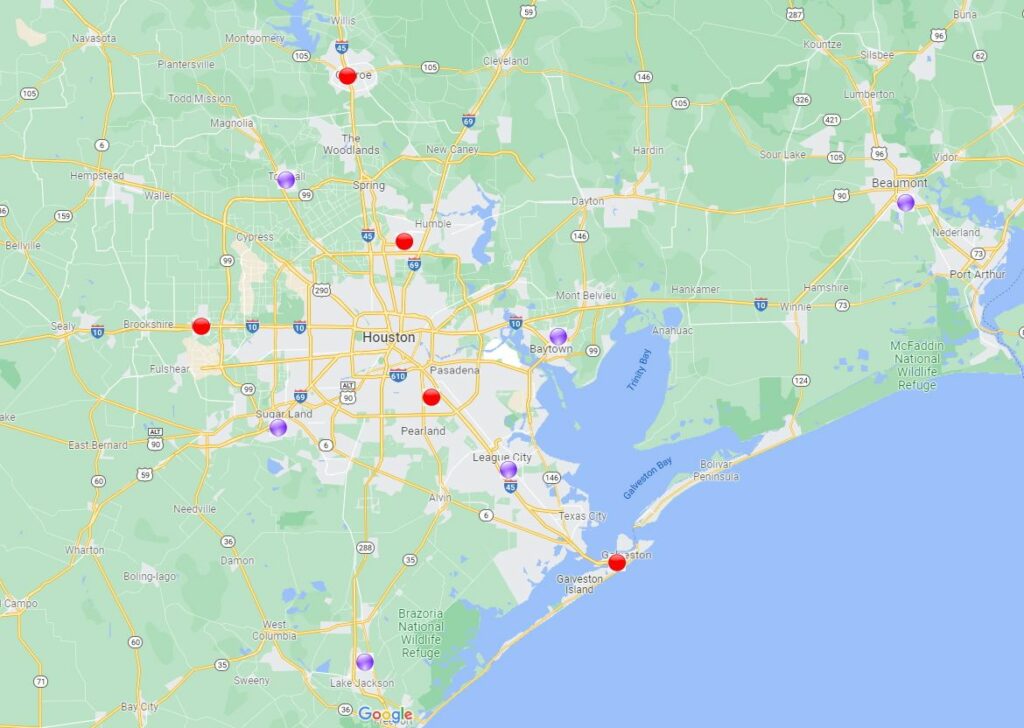
We’re starting to work on the next update of our app, which will feature several frequently requested changes, including the addition of more regions in the drop-down menu of cities, a much improved radar, an option for metric units, and more in addition to bug fixes. What I’d like your feedback on is which cities to include for the 7-day forecast and current conditions. The following map shows the current options in the drop-down menu (red) and proposed additions (in purple). If there’s somewhere where we’re missing, please let me know in the comments below. Thank you!