Houston’s weather will be governed by a strong front on Wednesday

Good morning. Temperatures have generally dropped into the 40s and lower 50s this morning across much of the region, but this flirtation with cooler weather will soon end as winds return from offshore. A stronger front arrives Wednesday, which will bring sunny days and chilly nights heading into Easter weekend. The holiday itself looks pleasant, although we can’t have complete confidence in the forecast this far out.

Monday

Temperatures will rise into the low- to mid-70s today, and really, it’s going to be a rather nice spring day. Skies will be mostly sunny, and winds light, shifting from the north to come from offshore later today. This will be most noticeable in Brazoria and Galveston counties, where some clouds may develop after noon, with a slight chance of showers as well south of Houston. The change in winds will also make for a warmer night, with lows only falling to around 60 degrees in Houston.

High temperatures on Tuesday will be the warmest of the week. (Weather Bell)

Tuesday

Southerly winds will become more noticeable on Tuesday, with mostly cloudy skies. We may see some gusts in the low 20s. The warmer, more humid flow will push temperatures to about 80 degrees, and may produce some very light, scattered showers across the region. Tuesday night’s lows will only drop into the upper 60s.
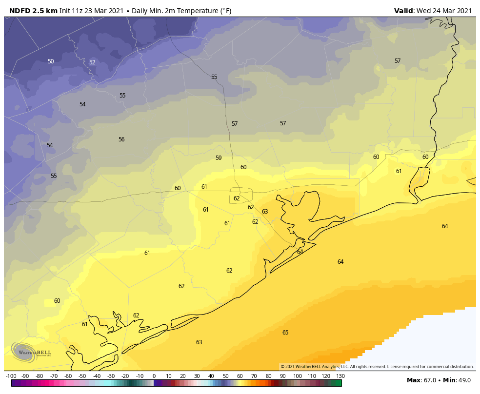
Wednesday

After a warm night, a cold front will swoop into Houston on Wednesday morning. We still have some questions about timing, but as a best guess the front probably reaches Katy and The Woodlands around sunrise, pushes into the central part of Houston by mid-morning, and off the coast by noon. It looks like a line of light showers will accompany the front, perhaps bringing a tenth of an inch of rain, or so, to most. Temperatures will drop into the 50s behind the front, with blustery northerly winds. Wednesday night’s lows should fall into the 40s for most areas but coastal counties.
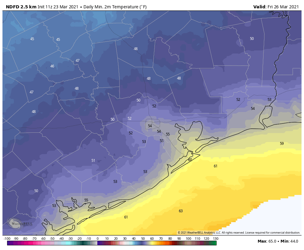
Thursday and Friday

We’ll see a sunny and chilly end of the week, with highs on Thursday and Friday in the 60s, and overnight lows Thursday night in the 40s, and low 50s on Friday night. We do not anticipate any freezing temperatures, even for well inland areas. Enjoy!

Thursday night’s temperatures will probably be the coldest of the week. (Weather Bell)

Easter weekend

Our confidence in the weekend forecast is not particularly high yet. I think we’ll see a mix of sunshine and clouds as the onshore flow returns. Saturday probably will see highs in the 60s, and Sunday will rise to around 70 degrees. While we can rule out any rain chances, for now I think the holiday weekend will probably remain dry.

Some sunshine coming for Houston before a cloudier weekend

Good morning. A cold front is pushing into the Houston area this morning, and its passage should be a mostly dry one due to a capping inversion over the region that is limiting the upward movement of air at the surface. We’ll then enjoy some drier air for about 48 hours before the weekend weather turns a little more uncertain.

Thursday

Cloudy and overcast skies this morning will give way to sunshine and drier air later this morning, or early afternoon, as drier air associated with the front moves into Houston. Highs will reach the upper 70s. Winds will also be notable, gusting up to 20 mph or so from the north and northwest as this drier air moves in. Overnight lows will drop into the 50s, and this will be the coldest night for some time in the region.

NOAA severe storm outlook for Thursday and Thursday night.

We’re also keeping a wary eye on the potential for storms—related to the front that moved through Houston—over the southeastern United States. Parts of Mississippi, Alabama, and Tennessee again find themselves in the crosshairs of tornadoes and other severe weather later today and tonight.

Friday

This should be a sunny, splendid day, with highs in the upper 70s. Winds will shift to come from the south later in the day, and this will make for a warmer night, with lows only dropping into the 60s.

Saturday

The first half of the weekend is shaping up to be warm, with highs in the low 80s, and partly sunny skies. As moisture levels rise due to southerly winds, we may see some very scattered, light showers during the daytime and overnight hours. Lows near the coast likely won’t drop below 70 degrees.

Sunday

Sunday’s weather will depend on how far a cold front reaches into the Houston region. We’re still not sure whether it will make it to about Interstate 69, or all the way to the coast, and our sensible weather is difficult to predict as a result. I think we’ll see better rain chances on Sunday, with scattered to widespread showers, and accumulation so perhaps a tenth or two of an inch. Highs for most will be in the upper 70s. Probably.

NOAA rain accumulation forecast for now through Sunday. (Weather Bell)

Next week

The aforementioned front may finally shove off the coast on Monday, but we’re likely to see something of a warming trend through the middle of the week. It looks like a stronger front will push through during the middle of next week, and this may bring some lows in the 40s into Houston, although I have very little confidence in such details. Still, the second half of next week could see one of the last reasonably cold spells of this spring.

Scattered showers possible before a front arrives Thursday

After the rains ended and skies cleared on Tuesday, the air still seemed hazy across some parts of the Houston area. This was due to a large dust storm, or haboob, that created a huge dust cloud over west Texas, and some of these particles were lofted about 1 mile high in the air and carried all the way across the state. Here’s a satellite view of the phenomenon that developed on Monday, and spread into the Houston region on Tuesday.

Wednesday

Winds have turned easterly today, and that will bring more humidity back into the area, as well as a chance of showers and thunderstorms. We’ll see this in the form of scattered to very scattered showers later this morning and during the afternoon hours. Highs will climb to about 80 degrees under mostly cloudy skies, with lows tonight only dropping into the mid- to upper-60s.

Severe weather outlook for Thursday and Thursday night. (NOAA)

Thursday

A cold front will approach and move through Houston on Thursday morning, likely pushing off the coast by around noon. This front will generate some more scattered showers and thunderstorms, but right now the system appears unlikely to be particularly organized as it moves through the region. Highs will get into the upper 70s with sunny skies after the front’s passage. Lows Thursday night will drop into the 50s with ample dry air.

Please note that if you are traveling eastward on Thursday, the setup is once again favorable for severe weather, including the potential for long-track tornadoes. The worst storms are likely over Mississippi and Alabama.

Friday

A lovely spring day, with clear skies and highs in the upper 70s. Lows Friday night will be about 10 degrees warmer that Thursday night, as the onshore flow reestablishes itself.

Saturday and Sunday

The weekend forecast is still a bit of a mess. We can be confident that Saturday will be warmer, with high temperatures in the low 80s, and more humidity. Skies will be partly sunny with a slight chance of rain. Saturday night should be warmer too, with some parts of Houston not falling below 70 degrees.

As for Sunday, a cold front will approach the area but my not quite reach Houston; may stall over the city, or may make it all the way to the coast. For now, I’d bet it stalls north of Houston, leading to partly sunny skies and highs of around 80 degrees on Sunday. But that is very much subject to change.

NOAA rain accumulation forecast for now through Sunday. (Weather Bell)

Next week

The models do seem a little more confident in the passage of a stronger cool front by Tuesday or Wednesday of next week, and this may also bring some chances for more widespread showers. But would I bet my house on this? Definitely not. I might bet Matt’s, however.

Morning thunderstorms will give way to clear skies

Good morning. A line of thunderstorms associated with a cool front is moving through the Houston region this morning, and these storms are strengthening a bit as they near the coast. For areas inland of Interstate 69/Highway 59, these showers are largely over, and they should clear the coast by mid-morning. These storms may produce briefly heavy rainfall, in addition to thunder and lightning. Please take care.

Tuesday

After the storms move through the area, we should see clearing skies. Drier air will follow, reaching northwest Houston this morning, the central city around noon and areas near the coast this afternoon. The question is whether the front itself makes it all the way to the coast, or lingers just onshore. This will have implications for whether places like Galveston Island and Chambers county see sunshine and drier air this evening, or not. Highs for most of the region will reach 80 degrees, and overnight temperatures will depend how far inland you live. The map below shows the forecast for lows Tuesday night.

Lows on Wednesday morning will depend how far you live from the coast. (Weather Bell)

Wednesday and Thursday

The front will return inland quickly, and as a result we’ll see increasing moisture levels on Wednesday in the atmosphere. This will basically make for gray, warm, and increasingly humid weather for Wednesday (highs near 80) degrees through Thursday morning. Some light scattered showers will be possible during this period. After that we’ll be on the watch for our next front, a bit stronger one. For now it looks like a capping inversion—warmer air aloft that prevents moist air at the surface from rising too far—should limit thunderstorms with this front. But it’s going to be a close call.

Regardless, it looks like the front will push through during the middle of the day Thursday, with showers ending by around Noon and clearing conditions afterward for most of the area. Winds from the north could be a bit breezy, gusting to around 20 mph. Lows Thursday night should drop into the 50s, with this being the coldest night for awhile.

Friday morning will definitely be the coldest of the week. Far inland areas will see the 40s. (Weather Bell)

Friday

Conditions looks quite pleasant for Friday, with sunny skies and highs in the upper 70s.

Saturday and Sunday

The weekend forecast remains somewhat in flux. Saturday now looks warmer and more humid, as the onshore flow resumes, with highs in the low 80s. Skies should be partly to mostly cloudy. Some scattered showers and possibly thunderstorms will be possible Saturday night before the passage of another front. This should set the stage for a sunnier Sunday, with highs near 80 degrees and drier air.

Next week should see a continuation of days with highs of around 80 degrees, and lows in the 50s or 60s.