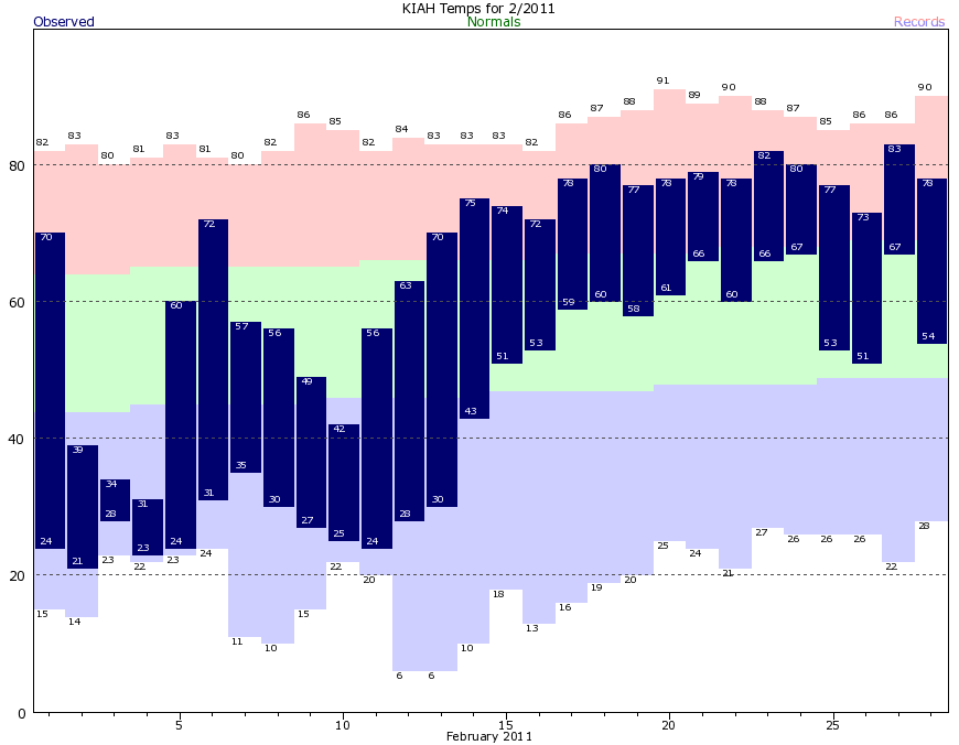
Yesterday I received several questions on Twitter, Facebook, and during a radio appearance about what this very cold start to 2018—temperatures are about 8 degrees below normal, and we have now had eight nights with lows in the 20s—portends for the rest of the year. For example, does a cold start to the year give us momentum for a cooler-than-normal summer? Alas, the answer is almost certainly no. Historically, there is little connection between winter weather and the subsequent summer. In fact, I’d offer the year 2011 as a counterpoint to this notion. During that year we had an especially cold start to February. Here’s a climate graphic from that month:
February, 2011, climate graph for Houston. (National Weather Service)
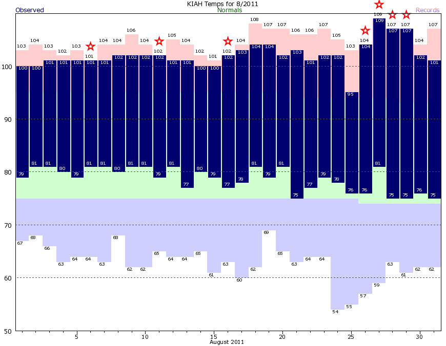
Note the frigid temperatures in the first half of the month, with nine nights in the 20s at Bush Intercontinental Airport, including five at 25 degrees or below. These are all hard freezes. A lot of you will remember the rest of the story, as 2011 ended up being the city’s hottest year on record at the time. August was especially brutal, with all but one of the days that month reaching 100 degrees.
August, 2011 temperature graph. (National Weather Service)
All of those stars in the graph above are record high temperatures. It was an absolutely brutal month. Let’s hope we’re not bound for similar weather this year.
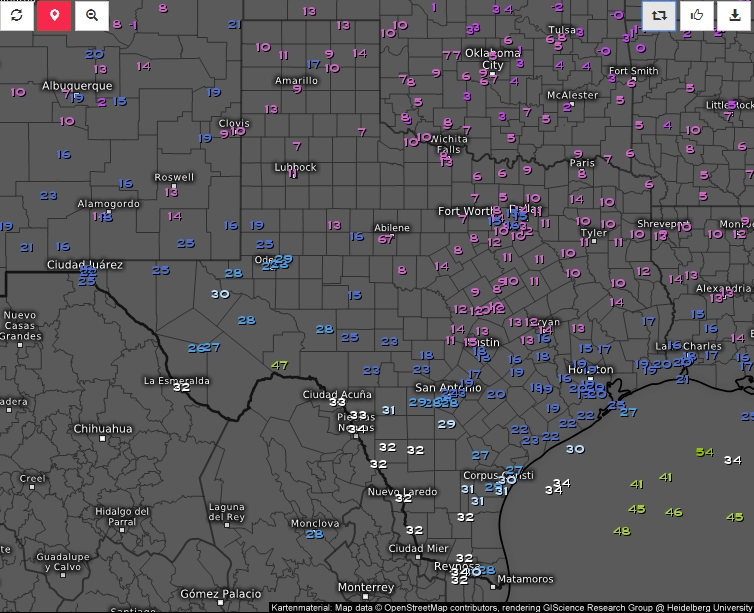
It’s an icebox out there, folks. After Tuesday night’s precipitation, skies cleared out from north to south, and shortly after midnight many areas saw stars. This, in conjunction with very cold Arctic air, brought the low in Huntsville down to 13 degrees this morning, as of 7am CT. Most of central Houston saw temperatures from 18 to 20 degrees. Even Galveston, our balmy, tropical Galveston with its lovely palm trees, fell to 25 degrees. The following map shows temperatures across Texas this morning.
Wednesday temperatures at 7am CT. (Weather.us)
It does not appear as though Houston will set a record low temperature for today (which is 15 degrees, set in 1930). However, this is the coldest it has been in the city since January, 1996, and the region has not registered a colder temperature since Dec. 24, 1989.
Wednesday
Area roadways remain a mess. Although some roads have dried out from Tuesday’s precipitation, ice remains a problem across the city—mostly on bridges and overpasses. As of 7am, Houston Transtar reports 137 areas of ice on roadways, and these are only the major thoroughfares. Sunny skies today will help the process of sublimating ice on roads, and by noon temperatures should reach above freezing for most of the metro area. Until then, travel will be dicey through the area. Check your route before you leave home. By this afternoon roads should be clear.
Highs today will reach the mid- to upper 30s before another cold night with lows around 20 north of the city, in the mid-20s in Houston, and near freezing along the coast.
Good evening. The last round of sleet and snow is marching through the Houston area, and by around 8pm the precipitation should be done for Houston today. For the next 24 hours there are three issues I want to discuss—icy roads this evening, frigid temperatures tonight, and when roads will clear on Wednesday.
Icy roads Tuesday night
Road conditions continue to worsen across the metro area this evening, and with sub-freezing temperatures and the loss of sunlight, there will be no real opportunity for concrete and asphalt to dry out. Already, Houston Transtar has reported 100 locations on major area roadways with ice, and that tally should continue to rise. Please do not venture out this evening or tonight, if at all possible. Sure, there is a chance you will make it to your destination without a problem. But there also is a chance you will not, and then place yourself, your passengers, and first responders in additional danger.
Overnight lows
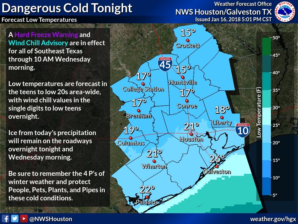
Houston faces a very, very cold night. Clouds this evening should help trap some of the heat, but some models predict that skies will begin to clear after midnight, and the earlier this occurs tonight, the better the chance for temperatures to really bottom out. The forecast shown below, from the National Weather Service, reflects what I think is a realistic worst-case scenario for lows tonight.
Forecast lows for Tuesday night and Wednesday morning. (National Weather Service)
You may have some concerns about pipes, given the cold temperatures. This site provides some good, general advice for a freeze like Houston will experience tonight. By the way, the record low for Jan. 17 in Houston is 15 degrees, set in 1930.
Wednesday’s roads
School districts faced a difficult call in regard to Wednesday. On one hand, it is going to be decidedly frigid on Wednesday morning, and some roads will certainly be icy in the Houston metro area. On the other hand, at some point Wednesday the ice is going to melt and it will be business as usual for Houston. Moreover, kids in most districts have already missed at least 12 days due to weather-related closures. In the end, almost every school district opted for the safe choice, and closed their doors.
Frankly, I’m not sure what conditions we’re going to see Wednesday morning. I think a fair number of roadways will be passable, but at the same time untreated bridges and overpasses will be deceptively dangerous. The big question for me is how much of the metro area’s elevated roadways will be treated with a solution to effectively melt the ice? I don’t know.
What I am confident in is that, sometime between 10am and noon on Wednesday, as the Sun comes out, and temperatures rise to above freezing, Houston’s roads will melt and dry pretty quickly—for good. By this weekend we should see highs rebound to the 60s, and we should remain there for most of the rest of the month.
As temperatures have plunged across the Houston area during the last six hours, rain has turned into a wintry mix of sleet, freezing rain, and snow. (Yes, it has already snowed lightly at Bush Intercontinental Airport this morning, the first time that has happened three times in a winter season since 1973). Here’s a look at what happens next.
More precipitation is coming
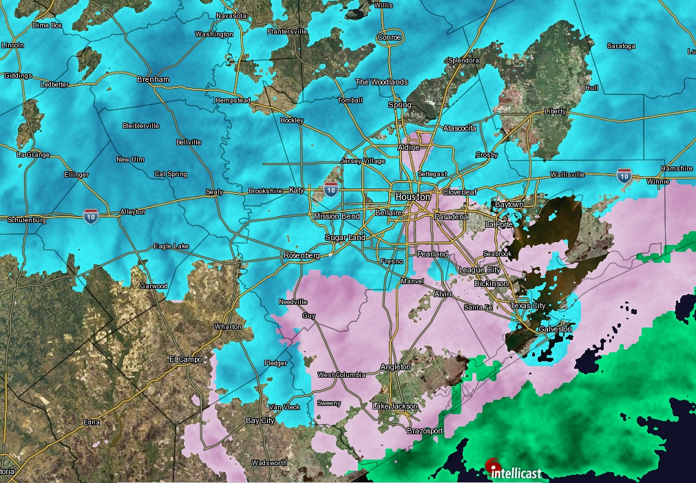
Houston has seen some breaks in the rain and sleet this morning, but there are additional areas of precipitation to the west of the region that will move into the metro area today. Although accumulations are unlikely to be too significant, it doesn’t take much moisture on the surface of a road to make it slick. Forecast models have been pretty consistent in bringing additional rounds of sleet, freezing rain, and snow through the region until about 4pm to 6pm CT today. Snow is more likely than other precipitation types this afternoon.
Houston radar at 10:55am CT on Tuesday. (Intellicast)
Roads are starting to freeze
Houston Transtar is keeping a (steadily growing) list of roadways affected by ice in the metro area. So far, most of the problems have occurred to the north, in Montgomery County, and west of Houston. This is understandable, as those areas have experienced freezing conditions for a longer period of time. Most roadways within Houston itself are still covered with just water, because the ground is still “warm” from Monday, when highs reached into the upper 60s. But now that most of Houston is now at about 30 degrees, and likely to slip into the upper 20s this afternoon, wet roads will gradually become icy roads—especially bridges and overpasses. How much of an ice rink Houston becomes depends upon the amount of precipitation this afternoon. With enough wind and breaks in the precipitation, there is a chance for some evaporation and perhaps we will have dry roads by the time the hard freeze hits tonight. Perhaps. But probably not. Best to leave work early today, if possible, and stay home this evening.