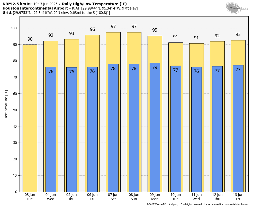
In brief: Houston will see typical June weather this week before temperatures spike this weekend. Highs in the upper 90s will coincide with an influx of Saharan dust that will make for hazy skies and deep red sunsets. Some relief may arrive next week.
Tuesday
If you liked Monday’s weather, you’re in luck, because today will be similar. Much of the region will see temperatures of around 90 degrees, or slightly above this afternoon, with mostly sunny skies. Winds will generally be from the south at 10 mph, with gusts up to 20 mph. From late morning into the afternoon we may see a few showers streaming inland from the coast, but overall rain chances are probably only about 10 percent. Low temperatures tonight will only drop into the upper 70s for most locations.
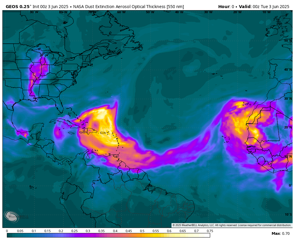
A plume of Saharan dust is spreading across the tropics this week and is bound for the Gulf. (Weather Bell)
Wednesday
A cold front will die north of the Houston area on Tuesday night, but it could perturb the atmosphere enough to generate some shower activity. Areas north of Houston (i.e. College Station) may see some showers and thunderstorms on Wednesday morning, with the broader Houston area seeing scattered activity during the daytime. Overall rain chances will be about 30 percent in the city, with mostly slight accumulations. Partly cloudy skies should help limit high temperatures in the lower 90s.
Thursday and Friday
These days will see a warming trend, with highs in the low- to mid-90s and mostly sunny skies. We cannot rule out a chance of rain, but it is likely on the order of 20 percent daily. We’ll continue to see southerly winds of around 10 mph, with higher gusts, and warm nights. Beginning on Thursday or Friday, and lasting into the weekend, we will see increasingly hazy skies due to the influx of Saharan dust. This is fairly typical for this time of year, and will reduce visibility while cranking up the vibrancy of sunsets.
High temperatures should peak this weekend. (Weather Bell)
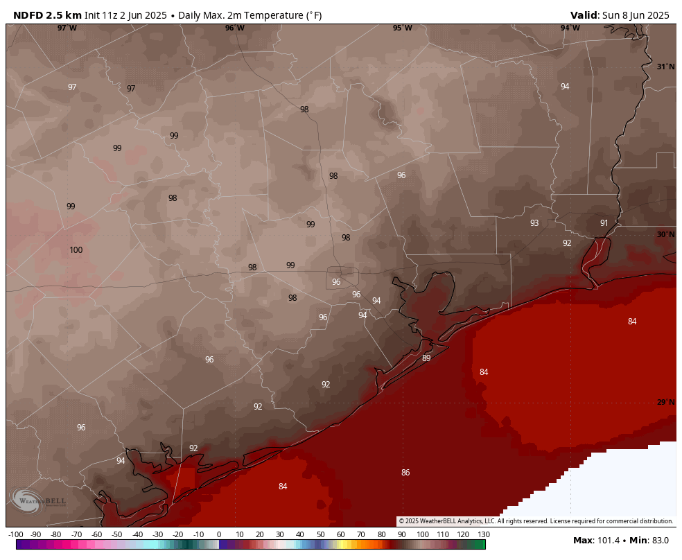
Saturday and Sunday
Hazy and hot. Highs both days should be in the mid- to upper-90s for most locations, with the possibility of some inland areas hitting 100 degrees as high pressure builds over the area. There will be a slight chance of afternoon showers and thunderstorms both days, but it likely is on the order of 10 percent. Nights will be sultry, with temperatures only dropping to about 80 degrees.
Next week
I am hopeful that high pressure will retreat some next week. This should allow temperatures to fall back into the lower- or mid-90s, and bring us a healthy chance of showers each day. This is nearly a week out, however, so no promises.
In brief: Today’s post shares some thoughts about the beginning of the Atlantic hurricane season, which fortunately appears to be starting slow. We also look ahead to some modest rain chances to start the week before high pressure and Saharan dust push our highs toward triple digits by the weekend.
Hurricane season begins
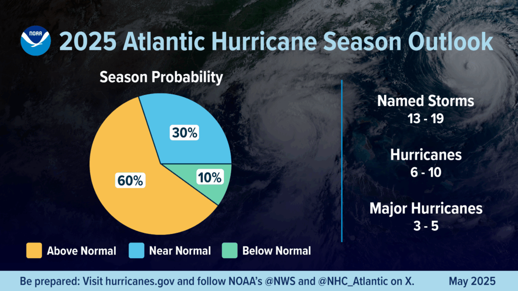
The Atlantic Hurricane season officially kicked off on Sunday, June 1. The season nominally lasts for six months, but longtime Houston residents will know that the season usually starts slow, and reaches its crescendo for our region in August and September, before the threat diminishes rapidly by the start of October. So it’s a long slog, but for us it’s typically a four-month slog rather than half a year.
April and May are what I like to call “hurricane season forecast season,” and we’ve seen dozens of outlooks. Having read most of them, I can tell you that almost everyone is calling for near-normal, or modestly above-normal activity this year. The reality is there are no hugely strong signals for what to expect. It does not appear as though El Niño or La Niña will have a major impact on the season, and although sea surface temperatures in the Atlantic are running above normal, they’re not excessively so. We have a deeper rundown of all of this on The Eyewall, but to be honest, none of it matters a whole lot. As always, prepare for any given hurricane season like normal, whatever the forecast is.
Seasonal forecast from NOAA.
As for the tropical outlook for the near future, as usual we have been seeing the US Global Forecasting model throwing out some wild solutions for a Gulf hurricane in the 10 to 16 day portion of its forecast. This is typical for this time of year, and can likely be safely ignored. We will, of course, continue to watch things closely and update Space City Weather with any tropical information that Texas residents need to know. For now it looks like we’re going to slide into the season quietly for at least the next week or so.
The most important advice I can give you is that a little bit of preparation goes a long way. Understand your vulnerabilities to wind, storm surge, and inland flooding, and know under what circumstances you would stay, and under which you will leave. Then make a plan for the supplies needed to hunker down; and have an idea of where you would evacuate to and what you would bring. With these plans made, you will be able to face whatever challenges arise this season with a measure of confidence. We promise that we’ll be here every step of the way.
Message from our long-time partner, Reliant
We first began supporting Space City Weather during the 2017 hurricane season (i.e. Harvey!) and have been grateful to Eric, Matt and the team ever since for keeping Texans informed and prepared during inclement weather. We certainly hope this year’s hurricane season will be a quiet one, but regardless, Reliant and Space City Weather will be there for you.
Take the time now to protect your family, home and business. Let this official kickoff serve as a reminder to prepare now, before the height of hurricane season here in Texas. Here are some tips to get you started:
Create or update an emergency kit to ensure you’re stocked up on essentials like nonperishable food, water, medical supplies, flashlights and radios. Be sure to customize your kit to fit your family’s personal needs.
Develop or refresh a communication plan with your family. This will ensure everyone is informed, on the same page and operating in a way that maximizes their safety. This includes sharing emergency contact info, including an out-of-state contact and enabling your phone’s emergency alerts.
Protect vital documents so you can easily identify yourself, submit insurance claims and request assistance. Important files, including personal, financial and legal documents, should be saved in a waterproof, fireproof bag and backed up digitally.
Know how to shut off water, gas and electricity in case of an emergency.
Invest in backup power. Backup energy solutions can help you ride out the storm, including portable options or whole-home generators like the one Eric and Matt have.
Check out more preparedness tips and recovery resources at The Reliant Storm Center: reliantstormcenter.com.
Monday
We’re starting June off warm, but not excessively so. Today should bring sunny skies and high temperatures in the vicinity of 90 degrees. Winds will be generally light, from the southeast at 5 to 10 mph. Lows will be modest, in the mid-70s. Compared to what is coming, this represents a rather benign start to summer in Houston (which for my money, also begins June 1).
High temperatures to start the week won’t be excessive, but just you wait. (Weather Bell)
Tuesday and Wednesday
Both of these days will have a puncher’s chance of some showers as a front drops into central Texas, but won’t reach all the way to our region. I’d say there’s about a 20 or 30 percent likelihood of rain, with the barest chance of a thunderstorms. Most of us will see partly to mostly sunny skies most of the time, with highs in the vicinity of 90 degrees. As for humidity, we’ve reached that point of the year where the humidity is going to be high every day in Houston. It’s a fact of life. Anyway, if you’re not impressed with the rain chances these days, they’re far better than what’s to come.
Thursday and Friday
These days should be a little warmer, with mostly sunny skies. Two things are going to happen during the second half of the week that are really going to make it feel like summer around here. One is that high pressure will begin to build from the south. And secondly, we’ll see an influx of Saharan dust that will turn our sunsets redder and help to clamp down on atmospheric moisture. The bottom line? Expect highs in the low 90s on Thursday and Friday as we transition into this pattern.
By this weekend some inland areas could be pushing triple digits. (Weather Bell)
Saturday and Sunday
Our temperatures should be solidly in the mid-90s to upper-90s this coming weekend, with sunny skies. Lows likely will be in the upper 70s. Need I say more?
Next week
The hot pattern continues for a couple of more days next week before there’s a possibility of some slight relief. This would take the form of some scattered showers and slightly lower daytime temperatures. But we’re still going to be in the 90s.
In brief: We’re interrupting your Sunday with a short update to call attention to the possibility of severe weather this afternoon and evening. Most people should not be impacted, but some may well be. If it starts to thunder and lighting, take cover.
Happy first day of hurricane season, everyone. We don’t have any tropical concerns right now, and we’ll have more to say about the upcoming season tomorrow. For now, I just want to briefly butt into your Sunday to call attention to the possibility of strong thunderstorms later today.
Right up front I want to be clear that this forecast is uncertain. Although there are some elements in place for severe weather, including some decent wind shear and convective available potential energy, not everything is in alignment. It’s sort of like baking a cake and skipping the baking powder and substituting for the eggs, and popping it in the oven. You’re just not sure what’s going to happen.
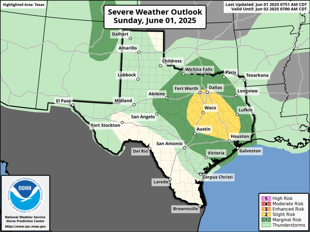
Severe weather outlook for Sunday and Sunday evening. (NOAA)
With that said, given the background conditions, there is the possibility of some strong and perhaps severe thunderstorms developing between mid-afternoon today and this evening. There are the usual threats here: briefly heavy rainfall, decently sized hail, and damaging winds. We also cannot entirely rule out a tornado, but the likelihood is low. Overall, the chances of severe weather are modestly higher north of Interstate 10.
Mostly, we are probably going to see mostly sunny skies this afternoon, with high temperatures in the low 90s. If you see storms, that’s probably going to be the exception rather than the rule. But the potential is there. Any inclement weather should calm down later this evening, and overnight. See you tomorrow morning with a full forecast.
In brief: The Houston area has had a wet week, and by and large this has been beneficial for the region before the onset of summer and the lurking potential for drought. We have a final chance late tonight and on Friday as a weak front moves into the area, providing a spark for showers. After that we’ll see June-like weather as June begins.
Rain status
Houston has picked up some much needed precipitation this week, with a vast majority of the region picking up up 2 to 5 inches of rainfall as a series of disturbances have passed through. As rarely happens, for Houston at this time of year, the region got just enough rain rather than too much; with our soils receiving a good drenching without too many flooding issues. This week’s rains put us in a much better posture heading into the coming summer, drought-wise.
Our rain chances have not ended. The primary driver over the next 36 hours will be an advancing front that stalls near the coast on Friday, bringing some decent rain chances to areas along and south of Interstate 10, before pushing offshore. However, we don’t expect too much in the way of organized storm activity. Oh, and if you’re tired of the rain, after Friday conditions look mostly dry for at least the next week or so.
Thursday
Our weather today will be mostly sunny, with high temperatures this afternoon pushing up to around 90 degrees or a touch higher. Winds, generally, will be light. (If you like to go bike riding in the evening, this will be especially noticeable). I think it’s possible that we will see some isolated to scattered showers this afternoon, but for the most part the region should be rain-free. Lows tonight will be muggy, in the upper-70s for most locations.
If you’re a fan of light winds, this evening may only see gusts of about 5 mph in the Houston area. This is a pretty stark contrast to what we’ve been seeing most of this spring. (Weather Bell)
Friday
On Thursday night a front will be pushing through Central Texas, and we could see a fairly strong line of showers and thunderstorms along the I-35 corridor advancing toward the Houston area. But as of now, I expect these storms to weaken some as they move down toward Houston. Still, I think the region will see a healthy possibility of some showers and thunderstorms on Friday morning, perhaps around sunrise or a bit later. We cannot rule out some hail and damaging winds with these storms, but overall odds seem fairly low.
As the front nears the coast it could stall, and thus for coastal counties we may see some lingering showers in the afternoon (or they may simply remain offshore). Skies will be partly to mostly cloudy on Friday, with light winds from the northwest. Highs will be around 90 degrees, with lows in the lower 70s.
Some inland areas may get lucky on Saturday morning and catch some low temperatures in the upper 60s. This will probably be the last time that happens until September. (Weather Bell)
Saturday
The front will usher in some briefly drier air. Don’t expect much, but humidity may be a tad lower on Saturday. Expect highs in the upper 80s with partly to mostly sunny skies. Lows on Saturday night may again drop into the lower 70s. Rain chances are near zero.
Sunday
Temperatures should reach around 90 degrees, or slightly above, with mostly sunny skies. We may see a few scattered showers during the afternoon as humidity levels recover some. Lows on Saunday night will drop into the mid-70s.
Next week
Most of next week should see mostly sunny skies with highs in the low 90s. We cannot rule out temperatures rising toward the mid-90s by the end of the week. However, conditions will feel fairly typical for June in Houston, which is to say hot and humid. Rain chances are low each day, but probably non-zero as a few areas may catch a stray shower.