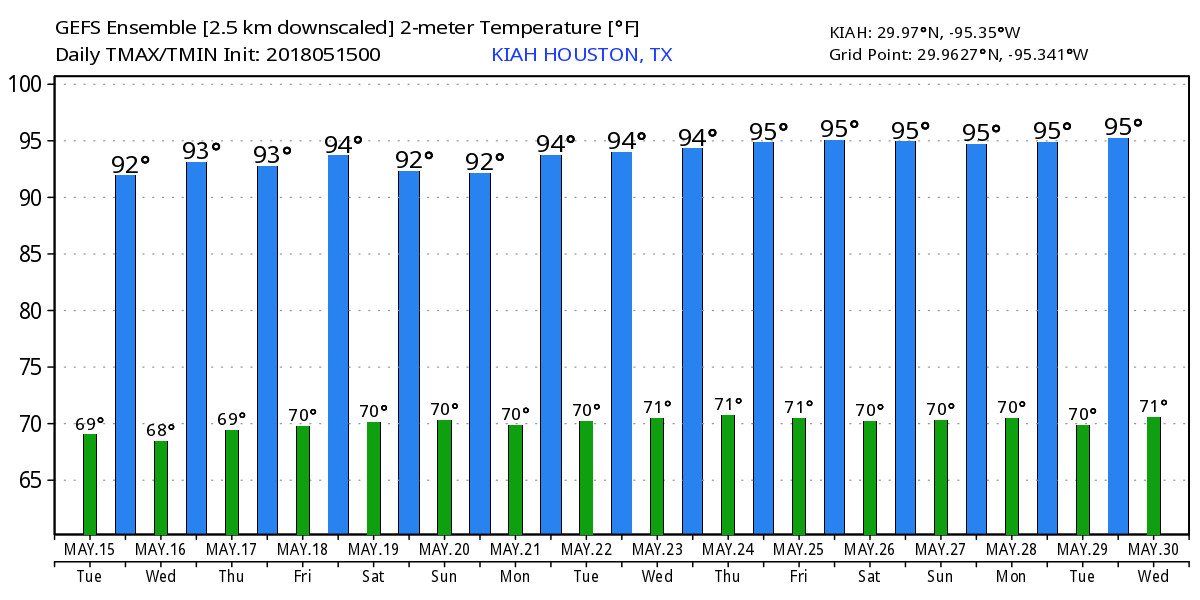
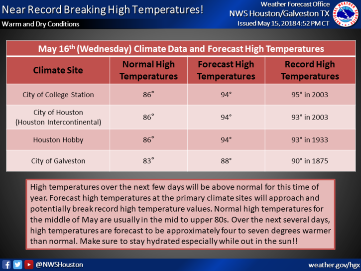
May’s site sponsor: Jetco Delivery

A Houston based transportation firm that serves Houston, Dallas and San Antonio—Jetco Delivery—has agreed to sponsor Space City Weather for the entire month of May.

Here are some reasons to choose them as a provider for your cargo delivery services:

When you need a “best in class” logistics and trucking partner.

No matter the size or security-sensitivity of your cargo, Jetco Delivery is committed to safely delivering your freight every time.

For over 41 years, clients have gained peace of mind because of our experienced, professional team, our newer fleet and  cutting-edge technology.

Together, we are going the extra mile.

Import/Export—Flatbed/Heavy Haul—Freight brokerage—Project management—Warehouse & Storage

Please join me in thanking Jetco Delivery for sponsoring the month of May in Houston. So far we’ve had great weather, but in this month thunderstorms are never far away.

Warming up, with a decent shot of rain this weekend

For mid-May, Houston just experienced a wonderful weekend, with cool nights, warm sunny days, and relatively low humidity. Unfortunately, the party’s over. Looking ahead we’ll see rather humid weather. On the other hand, it does appear as though we’ll get a healthy chance at some much-needed rain by the end of this week, or early next.

The Houston area isn’t close to a drought yet, but the second half of spring has been dry. (US Drought Monitor)

Today and Tuesday

Partly sunny skies will combine with a warm onshore flow to lead to two warm days, with highs in the upper 80s. Of the two days, afternoon clouds are more likely on Tuesday. Nights will remain warm with inland lows around 70 degrees, and warmer along the coast. Rain chances are near zero.

Wednesday and Thursday

A more southwesterly flow will arrive by the middle of the week, and with all the moisture in the atmosphere we’re going to see a chance of rain. However right now there’s doesn’t appear to be any real factors to force the issue—something that would drive air at the surface to rise. I wouldn’t expect accumulations of more than a tenth of an inch of rain, or two, from scattered showers and thunderstorms for most of the area. Highs will remain in the mid to upper-80s.

(Space City Weather is sponsored this month by Jetco Delivery)

See full post

A final spring fling for Houston? Front to dump humidity this weekend

It is quite warm across the Houston region this morning, and the muggy air will hang around for about 24 hours longer before a front rolls through to bring a bit of a reprieve from the humidity. The key question is how much rain might accompany it (not much). As most of Houston has only received about 2 inches of rain, or less, during the last 40 days we could certainly use some precipitation.

Today

Some light showers have streamed across northern parts of Houston this morning (primarily in the Montgomery County area), and for the most part I don’t see any rain falling in the city itself this morning. Some rain chances will linger into this afternoon, with thunderstorms possible if the cap over the region can be broken. Again, chances for this appear to be best north of the city. Otherwise, look for highs in the mid-80s with mostly cloudy skies.

Severe storms are possible north of Houston on Thursday afternoon and evening. (NOAA)

(Space City Weather is sponsored this month by Jetco Delivery)

See full post

Scattered rain possible this week before a front dries out the weekend

Good morning. Houston’s relatively mild weather for May will continue for awhile thanks to a front this week, and frankly we should savor these days as summer looms just around the corner.

Today

A few stray showers passed across Houston on Tuesday, and we’ll probably see similar conditions today—which is to say mostly cloudy skies with a slight chance of brief showers. Clouds should help limit high temperatures to the mid-80s, which is near normal for this time of year. Overnight temperatures remain warm and humid.

Thursday and Friday

Rain chances will increase marginally on toward the end of the work week as an upper-level low pressure system moves across the United States, and pushes a late season cold front through Texas. This will perturb our moist atmosphere enough such that we could squeeze out some rain showers ahead of the front on Thursday, and with its passage on Friday by or before noon. Amounts won’t be significant, with totals likely around one to two tenths of an inch for areas that do get rain. Highs on Thursday and Friday will likely reach the mid- to upper-80s.

Expect only moderate rainfall, if any, with a front this week. (NOAA/Weather Bell)

(Space City Weather is sponsored this month by Jetco Delivery)

See full post