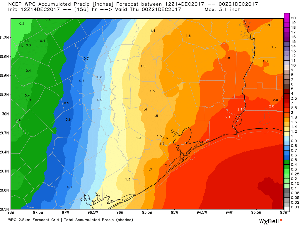
After very heavy rains overnight, Houston under flood watch

As discussed Monday night, a moist atmosphere and a storm system centered to the northwest of Houston produced very heavy rainfall during the overnight hours, with 1 to 6 inches of rainfall across the Houston metro area. The heaviest rains fell across the western part of the area, from areas such as Katy to Jersey Village. Most bayous have remained within their banks, but some are very nearly full. Some roadways are flooded this morning, and motorists should take care in driving around the greater Houston area. Freeways are largely passable.

Rainfall accumulation from 6:45pm Monday to 6:45am Tuesday. (HCOEM)


As of sunrise the bulk of the heaviest storms have moved off to the east, near Beaumont, and conditions are drying out over the greater Houston area. However, a flash flood watch remains in effect through 8am CT on Wednesday, due to the potential for additional storms to fire up this afternoon, and again during the overnight hours tonight. This is because a storm system in the mid-levels of the atmosphere remains anchored over the Waller County area. The concern, obviously, is that the heaviest rains again hit already battered western areas of the region. We will watch this closely and update as warranted.

The potential for heavy rainfall lessens—but does not go away entirely—on Wednesday and for the remainder of the week as pressures rise. Partly to mostly sunny skies should return by Thursday, and last through the weekend.

Posted at 6:50am CT on Tuesday by Eric

Heavy rains developing northwest of Houston, flooding possible

Just a quick update this evening to call attention to a large complex of thunderstorms slowly moving across northwestern Harris County, Waller County, and southwestern Montgomery County. Here, unstable air is combining with tropical moisture to produce very heavy rainfall.

The National Weather Service has issued a flood advisory through 1:30am CT on Tuesday morning, and some areas could see 3 to 5 inches of total rainfall from late Monday through early Tuesday. These rains could cause street flooding and potentially threaten some structures in low-lying areas. The primary concern is that as this system gets closer to the coast, and more tropical moisture, the storms could continue to strengthen.

Area of flood advisory in effect until 1:30am CT Tuesday. (National Weather Service)

In terms of motion, the storms seem to be slowly sagging southeastward, and may move deeper into Harris County tonight, possibly toward the central part of the Houston region.

Posted at 10:50pm CT on Monday by Eric

Heavy rain possible Monday and Tuesday, before showers pull back some

Houston will remain under the influence of a moist air mass during the next couple of days, which will lead to intermittent moderate to heavy rain showers, and cooler-than-normal temperatures. Frankly, this is very un-August-like weather, with widespread rainfall occuring across much of the eastern half of Texas, and highs of around 90 degrees. And for me, that’s a perfectly fine way to get through the dog days of summer.

Monday

A large complex of storms dropped as much as six inches of rain over central Texas on Sunday night, and this morning the system is moving from the west into the Houston region. It has lost some of its potency, but still could produce 2 to 4 inches of rain over some parts of Houston today as it runs into the moist Gulf of Mexico air mass. Other areas should see less rain, but most of Houston should at least see some showers. Mostly cloudy skies should keep highs in the low 90s. A healthy chance of storms will remain during the overnight hours.

The radar at 7am CT on Monday. For Texas, in August, this is a lot of rain. (Intellicast)

Tuesday

With low pressure (yet another advancing cold front that will stall over the area) and high moisture levels hanging around, I expect another day of widespread showers, with some thunderstorms producing heavy rainfall. For most people accumulations should be under 1 inch on Tuesday, but again there could be some localized street flooding issues under the heaviest storms. Highs around 90 degrees.

See full post

Cloudy, rainy weather to continue for Houston

Good morning. Houston’s cloudy, on-and-off again rainy weather will continue for several more days. I’ll also discuss the tropics, which seem likely to begin heating up soon as we’re now into August.

Thursday

Most of Houston saw 0.5 to 3.0 inches of rain on Wednesday, and while I don’t think today will be as wet, I do think the region will see fairly widespread showers and thunderstorms later this morning and during the afternoon hours. Accumulations shouldn’t be too concerning—i.e. they’re unlikely to produce some of the street flooding we saw Wednesday. Temperatures will remain pleasant for this time of year, with highs in the upper 80s to 90 degrees.

Friday through Monday

Not a whole lot is likely to change from Friday through the weekend, as a very moist air mass remains settled over the greater Houston region. This will bring partly to mostly cloudy days to the area, and a healthy 40 to 50 percent chance of rain. I don’t think we’re looking at any kind of significant flooding, and accumulations will probably be less than 1 to 2 inches for most areas

The heaviest rains are likely to be offshore this weekend. (Weather Bell)

Overall, the clouds should be enough to hold temperatures to around 90 degrees for the most part. One warning, if the Sun does come out for a few hours over your location, it will turn hot and steamy fairly quickly.

See full post