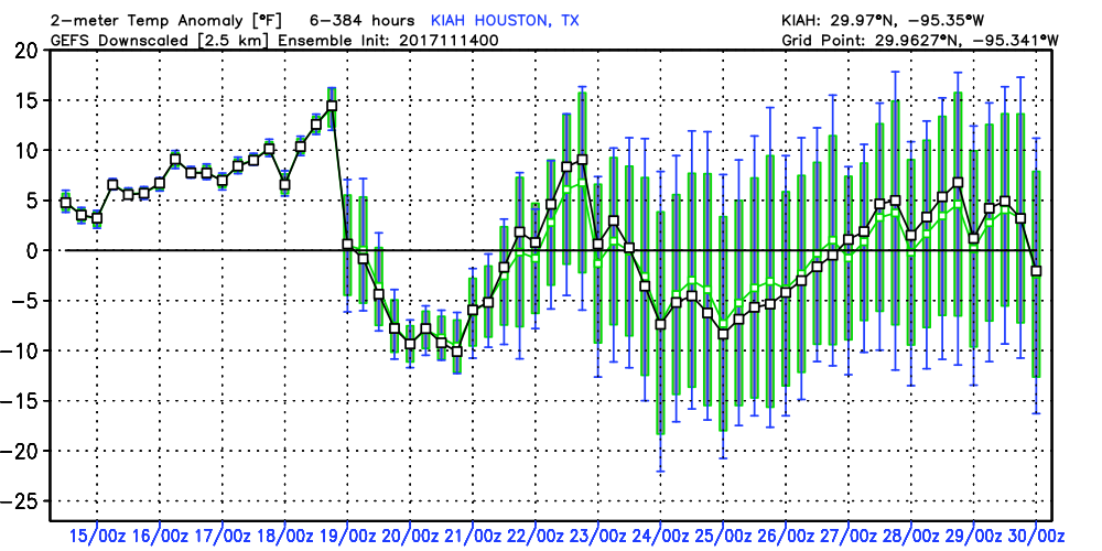
Storms possible today, and rain returns later this week to Houston

It’s another warm morning across Houston, with temperatures generally having fallen only to about 70 degrees. The main concern today will be the possibility of some storms and heavy rain along with the passage of a cold front.

Today

A cold front now in north Texas will move down toward the Houston area, likely pushing through the city during the mid-afternoon hours, and the off the coast by late afternoon. Due to decent moisture levels and and lift associated with the front, much of the area is likely to see some moderate to briefly heavy rain with the front’s passage. I’m expecting on the order of 0.5 inch to 1.0 inch or so, late this morning and during the afternoon hours. The storms may slow, or even stall along the cost, producing more rain there. Along with the front there will likely be some embedded thunderstorms, and a slight chance of some hail. After the front passes tonight look for temperatures to fall into the mid- to upper-50s.

(National Weather Service)

Wednesday

With northerly winds and partly cloudy skies the day will be moderately cooler, with highs in the low 70s. A very slight chance of rain returns during the late afternoon and evening hours. Most of the cooler air is gone by Wednesday night, allowing low temperatures to fall only into the 60s.

(Space City Weather is sponsored this month by an anonymous donor.)

See full post

After Sunday’s heavy rains, more storms possible Tuesday in Houston

Obviously, the big story this weekend was heavier than anticipated rainfall on Sunday. Our Friday forecast for the weekend was not particularly good. We missed on the potential for heavy rainfall and storms on Sunday, when some areas of southern Harris County recorded as much as 6 inches of rain. While there were no major flooding events as a result of the rain, and most of the region received 1.5 inches of rain or less, it is nonetheless regretful. It also serves as a reminder of the challenges of predicting heavy rainfall along the Gulf of Mexico.

Rain accumulation from early Sunday through early Monday. (NOAA)

Monday

It’s another very warm morning for early spring, with low temperatures only falling to around 70 degrees for most of the Houston area. After Sunday’s widespread showers, moisture levels remain fairly high over the region, but there’s not the same forcing to really drive the development of rain. As a result I think we’ll see some scattered rain showers later this morning and afternoon, but nothing too widespread. Highs will be around 80.

(Space City Weather is sponsored this month by an anonymous donor)

See full post

After two splendid days, rain returns to Houston this weekend

A sense of normalcy has returned to Houston this morning, as temperatures have fallen into the upper 40s across most of the region. This will be but a fairly brief respite, however, from the warmer weather of late. Also, we’ll probably see rain this weekend.

Today and Friday

In the wake of Wednesday’s cold front, pleasant weather will predominate for Houston, with highs in the upper 60s to 70 degrees, and cooler nights. How cool? Temperatures tonight could fall into the low- to mid-40s for many inland areas, and this will bring a real chill into the air. Friday night will be warmer, with the onshore flow starting to resume, but I still expect lows to fall to around 50 degrees for most areas. Skies will be partly to mostly sunny, with winds around 10 to 15 mph.

Saturday and Sunday

As the onshore flow resumes, rain chances will return to the metro area this weekend. The temperature forecast, at least, seems fairly clear. Both days will see highs from the upper 60s to low 70s, dependent somewhat on cloud cover, and lows probably down to around 60 degrees. The difficult part of the forecast comes in determining rainfall, which will depend upon the evolution of a low pressure system moving up into the region from south Texas on Saturday. The forecast models just don’t have a good handle on this yet.

Estimated rainfall totals for Houston for this coming weekend. (Weather Bell)

See full post

Houston just had its warmest morning for January, February or March

February ended on fire. According to the National Weather Service, the low temperature on Tuesday morning was 73 degrees—setting a record high minimum temperature for any day in February, in any year. This beat the old record by 2 degrees, would break or tie a record for every day in the city from January 1 through April 11, and matches the normal low for June 10. In summary, Houston’s warmest February on record ended with ridiculous weather, the same way we began it.

A month of record-setting temperatures in Houston. (National Weather Service)

Today

Low temperatures this morning are about the same as Tuesday, but fortunately a cool front arrives today, returning the region to more sensible weather for this time of year. The front should move through the region by around noon, and a capping inversion should prevent all but a few scattered showers from developing as it blows through. Winds could gust up to 20 or 25 miles out of the north this afternoon and early evening as drier air moves in. While afternoon temperatures should still reach about 80 degrees, conditions will cool off fairly quickly as the Sun sinks toward the horizon.

Thursday and Friday

As we’ve been saying for awhile, the end of the work week should provide some splendid, early spring-like weather, with highs in the upper 60s and low temperatures around 50 degrees, warmer along the coast and cooler inland. The only concern I have is for winds, which will be out of the north on Thursday (perhaps gusting to 15mph) and then out of the east and then southeast on Friday, perhaps gusting a little higher.

Saturday and Sunday

I’m starting to have some confidence that at least Saturday morning should provide decent weather for outdoor activities. I expect a high temperature of about 70 degrees under cloudy skies, as moisture levels rise. The tricky question remains the timing of any rainfall, which could begin as early as Saturday afternoon, or not start until Sunday morning. In any case, I think most of the region is probably looking at picking up about 1 inch of rain this weekend. Highs on Sunday should rise into the mid-70s.

Early next week

As has been usual for the region this winter, Houston will fall into a “warm” pattern for most of the next work week, as it looks like high temperatures will be between 75 and 80 degrees, and lows in the 60s. So if you enjoy cooler weather, this Thursday and Friday are for you.

Posted at 6:55am CT on Wednesday by Eric