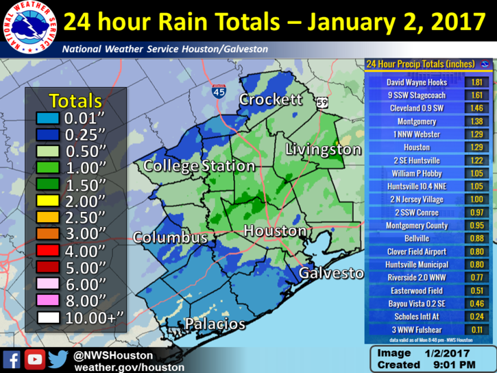
Houston’s weather has quieted down after Monday morning’s severe thunderstorms, which brought generally 0.25 to 2 inches of rain to the entire metro area. This map shows the heaviest accumulations just to the northwest of Houston:
And although December may have ended on a warm note, with five of the last eight days seeing highs of 80 degrees or greater, a cooler start to the month kept the average temperature to 58.6 degrees. This was cool enough to finish just outside the top 10 warmest Decembers on record for Houston.
Today
It’s noticeably cooler this morning, as lows have generally fallen into the 50s across the region. Houston will warm up considerably this afternoon under mostly sunny skies as winds are already blowing in from the southwest at 5 to 10 mph, and this should allow highs to climb into the mid-70s. But another, likely dry front will move through this afternoon, putting the kibosh on any significant warming this week. Lows tonight should fall into the 40s, except for immediately along the coast.
(Space City Weather is sponsored by Westbury Christian School for this month)
Wednesday
Much colder, with mostly sunny skies and highs in the 50s. Overnight lows again mostly in the 40s across Houston.
Thursday
We’ll warm up a little bit, with highs climbing into the 60s, and winds may briefly swing back out of the southeast. However a stronger cold front will arrive later on Thursday or Thursday night and set the stage for a cold end to the week.
Friday
After the front passes some forecast models indicate that an atmospheric disturbance will move into the area, and bring a healthy chance of light rain, especially along the coast. The net effect of this should be cold (40s), gray and potentially wet weather from Thursday night through Saturday morning. A light freeze is possible for northern areas on Friday night, but I expect most of Houston to remain at, or a few degrees above freezing.
Saturday and Sunday
Good news for Texans fans! After a cold, gray start to the day skies should clear out by late morning, or so, on Saturday, allowing for the Sun to come out. Absent rain the main concern Saturday afternoon will be temperatures, which will likely rise only into the mid-40s by the playoff game’s 3:35pm CT kickoff time. A northerly breeze of 10 to 15 mph will also make things cool—but fortunately prime tailgating hours will occur during the warmest part of the day. It will be cold coming out of the stadium without any sunshine, however, and much of Houston could fall to around 30 degrees on Saturday night. Areas in Montgomery County and otherwise outside of Houston may see lows in the mid- to upper-20s on Saturday night.
Sunday will be pleasant, sunny and cold, with highs of around 50 degrees.
Next week
After a cool start to next week, most of the work week looks to return to a more spring-like pattern with highs in the low- to mid-70s. For the marathon runners I’ll have a comprehensive update later this morning.
Posted at 6:30am CT on Tuesday by Eric
About 0.8″ in beautiful downtown Ellington yesterday – all within less than an hour.
Heard rumors from friends in Knoxville and Charlotte about a big mid-South snow event possible this weekend. They’ve heard about upwards of a foot possible. Any news on that, Eric?
Certainly possible, but still a lot of uncertainty. Haven’t paid that much attention to it, to be honest.
Looks more like 1-2″. Apparently an outlier model or two hit the media and they ran with it.
They should be able to handle a couple of inches u there. It would probably shut this place down for two weeks – after it melted.