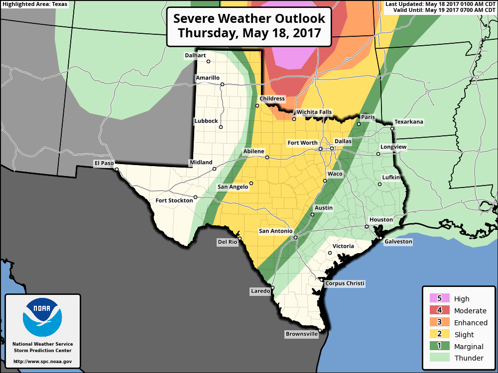
Very warm through Friday, storms possible on Saturday, and then cooler

Houston remains under a dense fog advisory until 9 a.m. this morning.

TODAY-FRIDAY

The region will continue to see a warming trend, with highs in the mid-70s today, and possibly record high temperatures around 80 degrees on Thursday and Friday. Lows will climb from the upper 50s Thursday morning to nearly 70 degrees by Saturday morning. Skies will be mostly Sunny.

Mele Kalikimaka, everyone.

SATURDAY

Moisture that has piled up during the previous three days will rise upward due to an advancing front. This will bring about a decent chance of rain during the day, and an even better chance on Saturday evening and during the overnight hours. Due to the unstable nature of the atmosphere some severe thunderstorms will be possible, with possibly even some isolated tornadoes. Check the forecast before heading out to any evening or nighttime plans.

In terms of accumulations, I still think 1 to 2 inches is a good bet for rainfall.

See full post

Warming up for a soggy Saturday, then hopefully drier on Sunday

It’s another chilly morning across Houston, with temperatures in the 40s across the metro area, but we’re going to transition out of the cool pattern we’ve been in for the rest of the week.

TODAY-FRIDAY

We’re going to see gradually warming conditions over the rest of the work week, and we’ll also start to see some clouds. Please do not be alarmed by white, fluffy, cuddly looking things in the sky. Those are clumps of moisture that have condensed. They are not harmful.

High temperatures will rise from the low 70s today to the upper 70s by Friday, and low temperatures will increase from the 40s today, to the 50s on Wednesday and Thursday morning, and into the lower 60s by Friday and upper 60s by Saturday morning. As temperatures rise, humidity levels will too.

Because we’re so dry rain chances will remain very low.

See full post

Gradually warming this week, rain possible next weekend

What a gorgeous weekend. Our run of sunny, winter-like weather will continue today and Tuesday before warming up this week.

MONDAY-TUESDAY

High pressure will keep things cool and sunny, with highs around 70 degrees, and overnight lows on Tuesday morning in the upper 40s. Basically, the weekend weather continues for a couple of more days.

WEDNESDAY-FRIDAY

After high pressure finally moves off to the east we’ll see a return flow from the Gulf of Mexico gradually build up. Skies will remain partly to mostly sunny, however, because there’s so little moisture to begin with over the Houston area.

Expect highs to rise from the mid-70s on Wednesday to the upper 70s to nearly 80 degrees on Friday. Overnight lows will rise from 50 degrees on Wednesday to nearly 70 degrees on Saturday morning.

See full post

Cool days and cold nights: Our new normal

Temperatures are quite cool across the Houston area this morning, with lows around 40 degrees. Welcome to the new normal.

TODAY-TUESDAY

Houston will see more or less similar conditions for the next six days — highs in the 60s, lows in the low- to mid-40s, with lots of sunshine. Just when the onshore flow would resume this weekend it looks like another cool front will arrive to keep us in this pattern through the first part of next week. Rain chances are near nil.

Friday morning will be our coldest one of the week. (Weather Bell)

See full post