For most of us running the upcoming Houston marathon on January 15th we had our last, semi-long run this past weekend, and it’s time to taper down to the main event. We’ve trained. We’ve worked hard. And now we’re at the mercy of Mother Nature. So let’s discuss what’s in store.
When it comes to forecasting weather conditions nearly two weeks out it’s important to remember that forecast models have limited accuracy after about 10 days. Perhaps the best way to gauge conditions from this far out is to look at the ensemble runs of global forecast models. That is, the GFS and European models are each run about 50 different times with slightly different starting conditions. This gives a range of outcomes, and from looking at all of these ensemble runs we can get some probabilities on conditions.
Houston welcomed the New Year with some severe thunderstorms moving through the area on Monday morning. Although some embedded storms were quite heavy, as they moved quickly there was little time for floodwaters to accumulate. The primary threat came from winds, with a few gusts reaching 60 mph to the north of Interstate 10. An additional line of storms will move through before 10am CT, but then we’re going to clear out. A couple of cool fronts will bring temperatures down this week, but there’s still a fair amount of uncertainty about how much colder conditions will get this weekend.
Today
After the storms clear out winds should pick up out of the west, bringing some drier air into the region and allowing overnight lows to slide down into the 50s—lower 50s up north and upper-50s closer to the coast. Before that happens a sunny afternoon should allow highs to reach near 80 degrees, however.
Tuesday
A rather pleasant day. Humidity levels will be lower with more westerly winds, and highs should climb into the 70s under mostly sunny skies. A cool front will arrive around sunset, give or take a few hours, and it should be a dry passage. This should push overnight lows into the upper 40s for most of Houston.
Wednesday and Thursday
Conditions will feel more winter-like with northwesterly winds. Under partly to mostly sunny skies expect highs of around 60 degrees, with lows in the 40s.
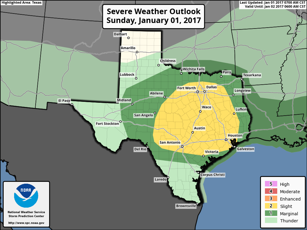
Happy New Year! As expected, New Year’s Eve brought a lot of moisture into the Houston region, but the rain moved out before the beginning of evening festivities during the evening, leaving behind a foggy, humid, and misty day to start 2017. More rainfall is on the way, however, with the potential for some severe weather late tonight and Monday morning.
Dewpoint temperatures this morning are in the 50s, and although conditions are calm at the surface, about a mile up into the atmosphere south-southwesterly winds will be increasing today, rising to about 50 mph in the lower levels of the atmosphere by Monday morning. This will both bring lots of moisture and shear into the area late tonight and on Monday—setting the stage for some severe weather. The most likely time for storms will occur from after shortly after midnight tonight through noon Monday, with storms moving fairly rapidly from west-to-east.
Storm outlook for Texas on Sunday and Monday morning. (NOAA)
The primary threat will come from severe thunderstorms, damaging winds, hail and potentially a few tornadoes. Better chances for storms and higher rain accumulations will come north of I-10, where some areas may see 1 inch or more of precipitation.
As storms move out of the area by late Monday morning, skies will clear out and highs should rise to nearly 80 degrees. Cooler, drier air will arrive by Monday night, with a reinforcing shot of colder air later this week. How cold temperatures get by Friday or Saturday morning is not entirely clear, but forecast models have backed off the idea of an Arctic surge driving lows into the 20s.
We’ll update tomorrow morning with a comprehensive look at the week ahead, and out first forecast for the 2017 Houston Marathon.
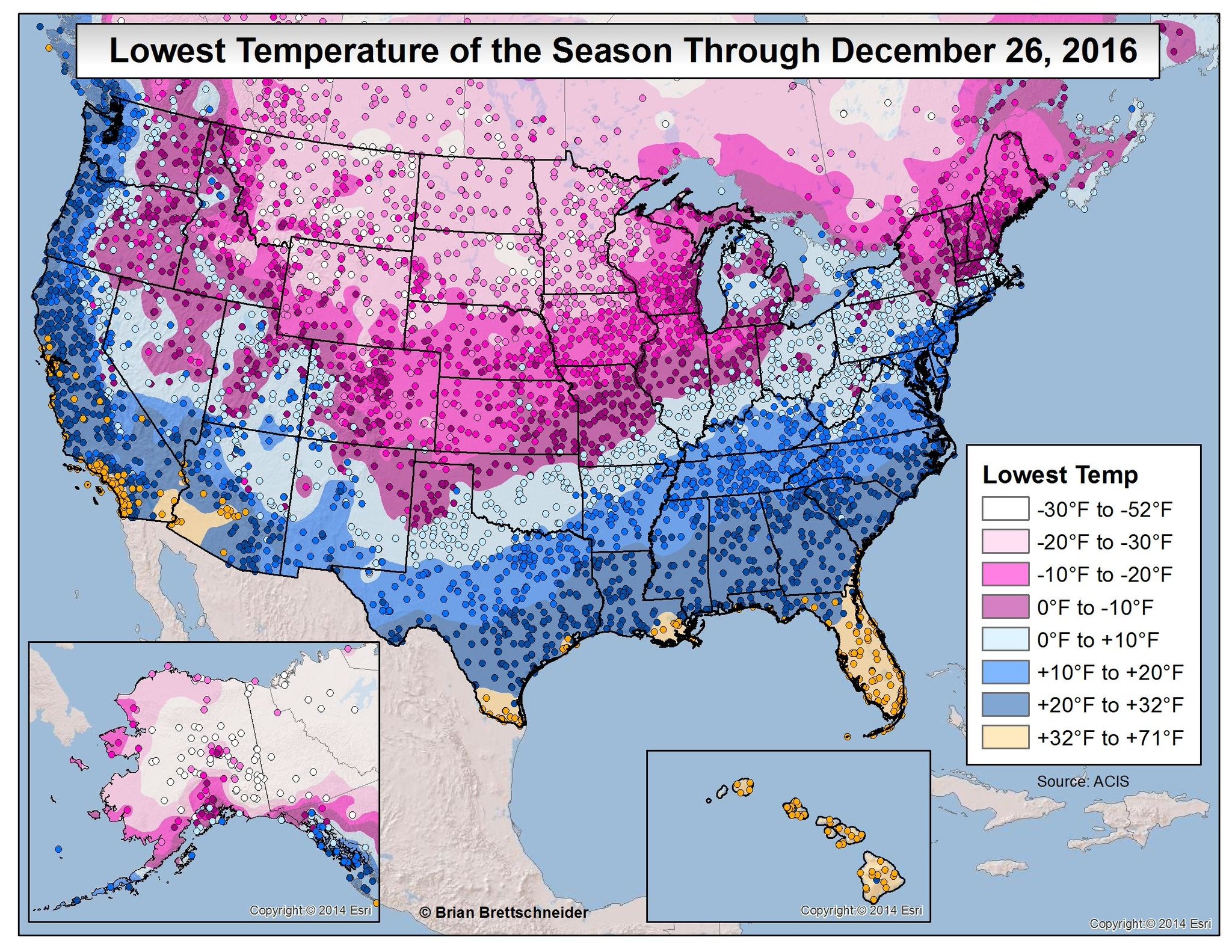
As of 7 am CT a cold front has swept through most of the Houston area, bringing an end to the warmest late December streak of weather in the city’s history, an unprecedented five days of 80-degree weather during the Christmas to New Year’s period. As we swing back toward colder weather here’s a look back at the coldest temperatures across the region this season, so far.
Map of the lowest temperatures so far this winter. (Brian Brettschneider)
Notably a few parts of Texas, Louisiana and the southwestern United States have yet to experience a freeze this year. Now let’s zoom in on southeast Texas, where you can really see the effect of warmer waters in the Gulf of Mexico and Galveston Bay on land temperatures. A small slice of the coast has yet to freeze, and that’s unlikely to change in the next week or 10 days.
Lowest temperature of the season for the greater Houston area. (Brian Brettschneider)