For most areas of Houston the first freeze of the season arrived this morning, including a mark of 30 degrees at Bush Intercontinental Airport. This official “first freeze” of the season comes nearly nearly three weeks late for the city’s official weather station.
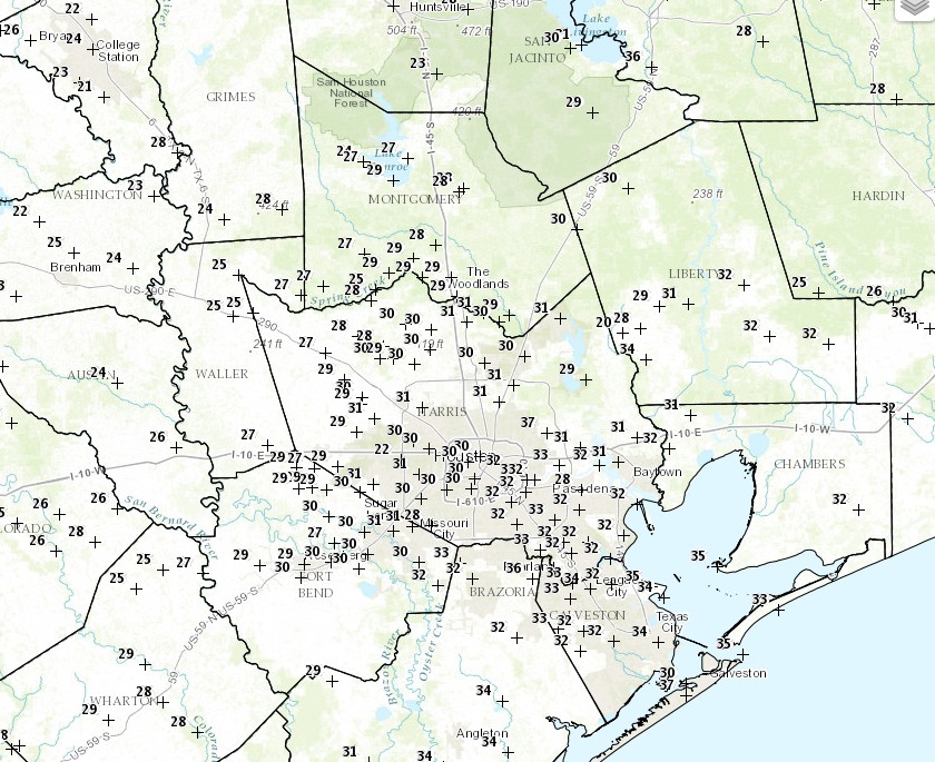
The following map shows temperatures across the region as of 7am CT, which range from the low 20s near College Station to upper 30s immediately along the coast. With winds still in the 10 to 15 mph range this morning, wind chill temperatures across most of Houston are in the teens to low 20s—very cold.
Temperatures at 7am CT on Monday morning. (National Weather Service)
As anticipated, it’s warm and breezy across Houston today with high temperatures reaching about 80 degrees as of noon. Brisk, southerly winds are gusting in from the south at up to 30 mph along the coast. Change, of course, is coming soon. We’ve been talking about a strong cold front arriving on Saturday night, and it as strong—if not stronger—than advertised.
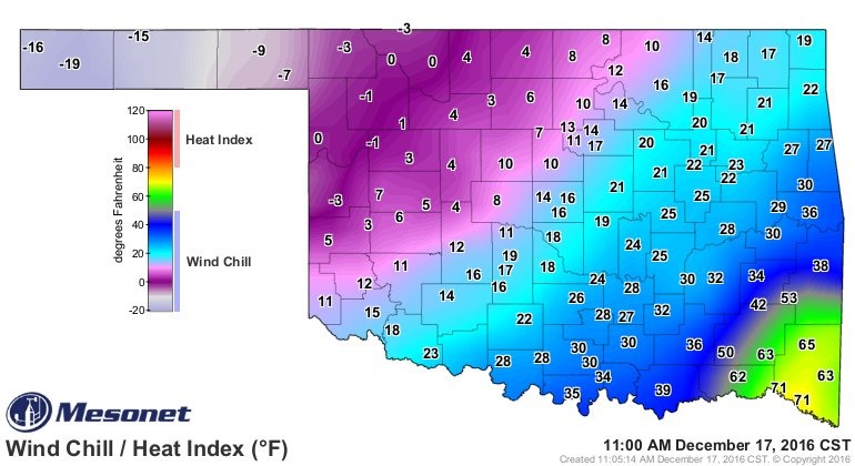
The graphic below shows the swing in wind chill temperatures before, along and behind the front as of 11am CT in Oklahoma this morning. This represents a 90-degree swing in temperatures from the Oklahoma Panhandle to the southeastern corner of the state.
Wind chill temperatures in Oklahoma on Saturday morning. (Sam Lillo/Twitter)
Good morning. Temperatures are quite a bit cooler, with much of the region having fallen to around 50 degrees, or lower. We’ll warm quickly, but a much stronger front looms Saturday night, with a freeze possible in Houston Monday morning as winter returns.
Today
As drier air continues to filter into the Houston region, we should see clearing skies today and cool temperatures. Expect highs generally in the upper 50s with moderate northerly winds, and another cool tonight with temperatures again falling to the upper 40s for inland areas, and lower 50s closer to the coast.
Friday and Saturday
The warmth returns with vengeance. Winds will gradually shift to the east and then from the south beginning Friday morning, and this onshore flow will push temperatures higher quickly. Under mostly cloudy skies look for highs in the mid-70s on Friday, with overnight lows in the upper 60s for inland areas and (unbelievably) lower 70s for coastal areas. This will probably make for cloudy conditions on Saturday morning.
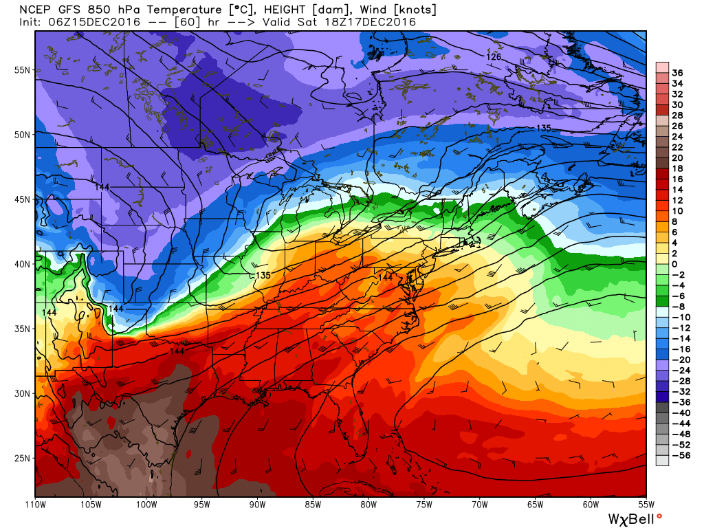
This depiction for winds and temperatures in the lower level of the atmosphere on Saturday at noon is helpful. It shows the very strong southerly winds and warm air advection from Mexico and Texas into the southern United States. Meanwhile, a front advances. (Weather Bell)
After the city of Galveston broke both its the daily (Dec. 13) and monthly (December) record high temperatures, reaching 81 degrees on Tuesday, the Houston area’s winter “heat” has broken—for now. We’ll have to wait until this weekend for a major cooldown.
Today
A moderate cool front has moved into the Gulf of Mexico, and northerly winds today should finally bring some significantly drier air into the region by this afternoon and evening, clearing skies. Highs today should climb into the upper 60s under mostly cloudy skies.
Thursday
Temperatures should fall into the upper 40s for most of Houston tonight, except for coastal areas, and Thursday should be another cooler day in the wake of last evening’s front. Highs will struggle to reach 60 degrees across much of the metro area. However onshore winds will return sometime later on Thursday, setting the stage for an unusually warm end to the week.
Friday and Saturday
As moisture returns, so will the humidity, and more potential problems from early morning fog. The region will also see some rain chances on Friday and Saturday, but I think we are only looking at fairly scattered, mostly very light rain.
High temperatures should rise into the mid- to upper-70s on both days under partly to mostly cloudy skies, and I think Saturday will probably be quite breezy as a strong wind establishes itself out of the south. Parts of Houston could see gusts around 20 mph. If you don’t like soupy weather in December, change is coming.
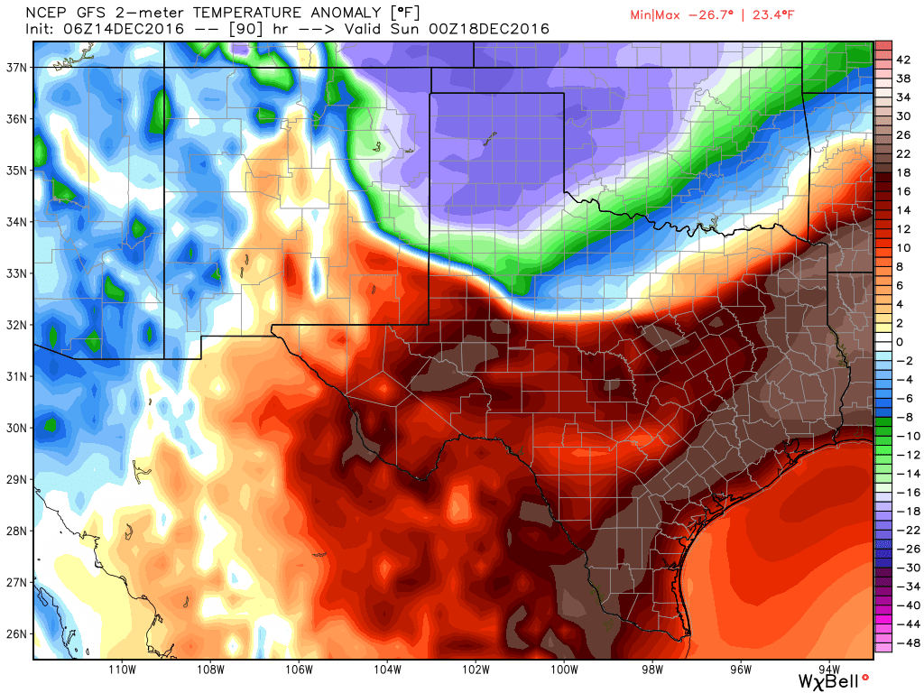
Temperatures will be anomalously warm on Saturday evening, 15 to 20 degrees above normal But look at what is coming! (Weather Bell)