In brief: We are issuing a Stage 1 flood alert for Saturday due to the possibility of slow moving storms capable of producing rainfall rates of 1 to 2 inches per hour. Activity should wane this evening, with less coverage on Sunday.
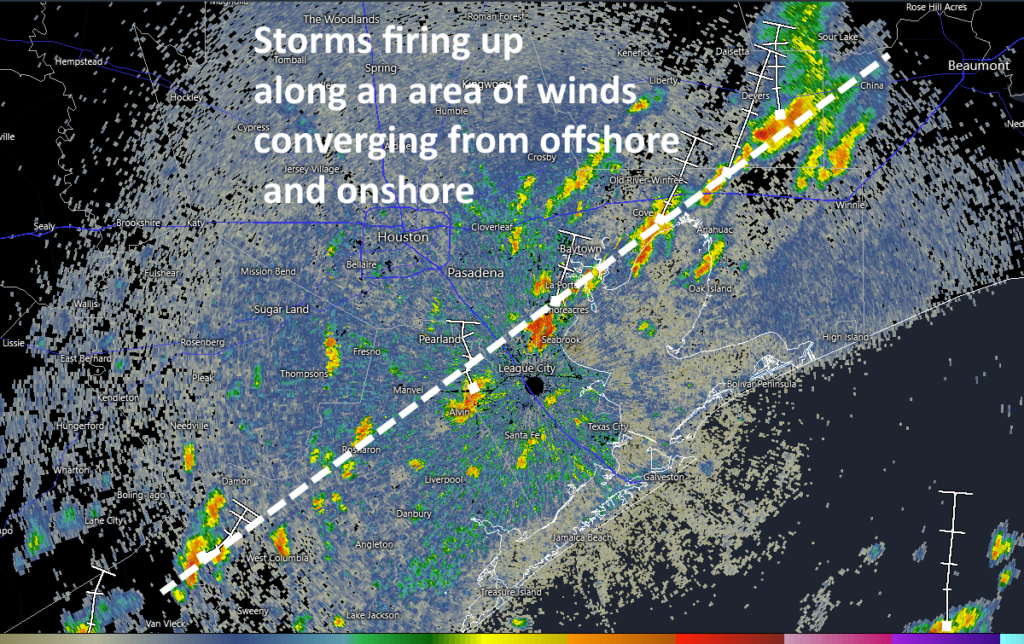
After a fairly quiet start to the day, we are seeing storms firing up along an area of convergent winds near the coast. At 11 am CT these storms have formed roughly along a line from Bay City to Pearland to Clear lake to Baytown. The heaviest of these storms may briefly produce rainfall rates of 1 to 2 inches per hour.
Houston radar reflectivity at 11 am CT. (RadarScope)
So what will happen during the rest of today? Our high resolution modeling guidance has not been, to put it politely, great. But given the high levels of precipitable water (well above 2 inches for most of the region) we are now leaning toward a fairly active day today in terms of showers and thunderstorms. Some parts of the metro area will get hit, while others just hear distant thunder. Because some of this activity may be slow-moving, we are going to issue a Stage 1 flood alert through this evening, which indicates the possibility of street flooding.
Creeks and bayous across the Houston region are generally in good condition, so we don’t expect more than nuisance flooding (that is, streets, feeder roads, etc) for today. But this activity could definitely put a damper on outdoor activities. Beyond heavy rainfall there is the threat of thunder and lightning, but no real indication of severe weather such as damaging winds or hail.
Our expectation is that storm activity will begin to wane this evening and then should die off overnight. Rain chances should be lower on Sunday, probably in the vicinity of 20 percent. Rain chances next week will be near zero, with sunny skies and highs in the mid-90s (at least) as high pressure asserts control. So if you’re tired of the rain, its end is at hand. Just not quite yet.
In brief: We talk about why, when Arthur’s center was closest to Houston on Wednesday evening, its winds died off. Also, we look ahead to calmer and hotter conditions for the next couple of days, and some rain chances over the weekend.
Looking back at Arthur
Can we agree that it was an odd storm?
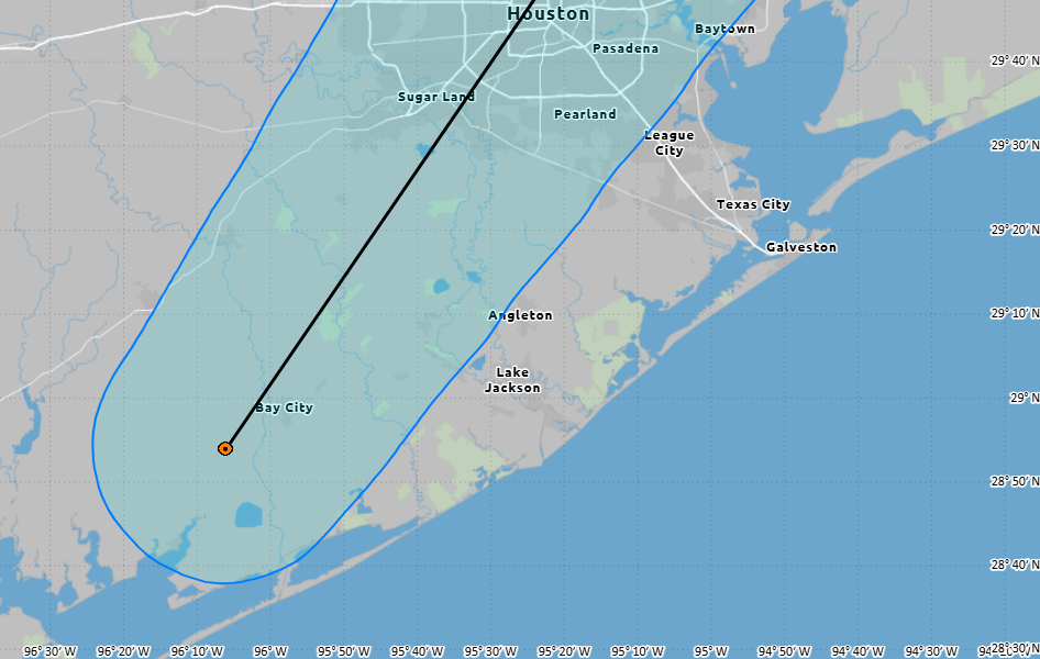
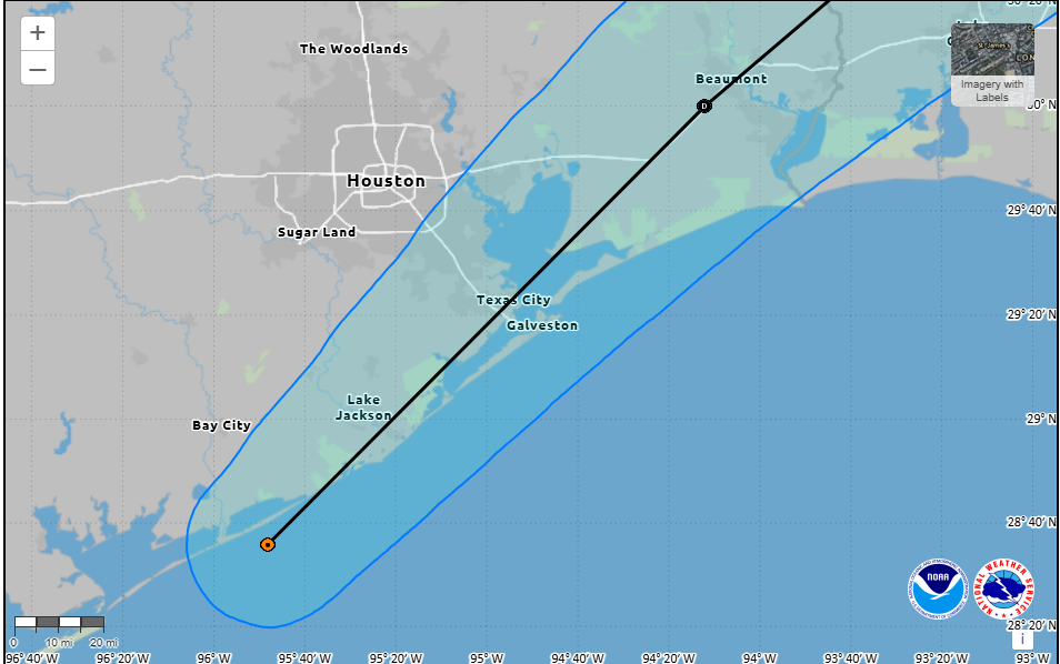
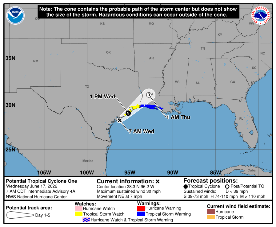
Here’s the National Hurricane Center forecast for the position of its center at 4 pm CT on Wednesday, along with a track forecast.
Forecast position of Tropical Storm Arthur at 4 pm CT Wednesday. (NOAA)
I received a couple of messages yesterday afternoon from readers asking if they should be concerned about this updated track because, as you can see, the center of the storm is forecast to pass directly over Houston on Wednesday evening. And if this were a typical tropical storm or hurricane, the answer would be yes. But I replied no, nothing really had changed with our forecast because the winds and rains associated with Arthur were located hundreds of miles to the east
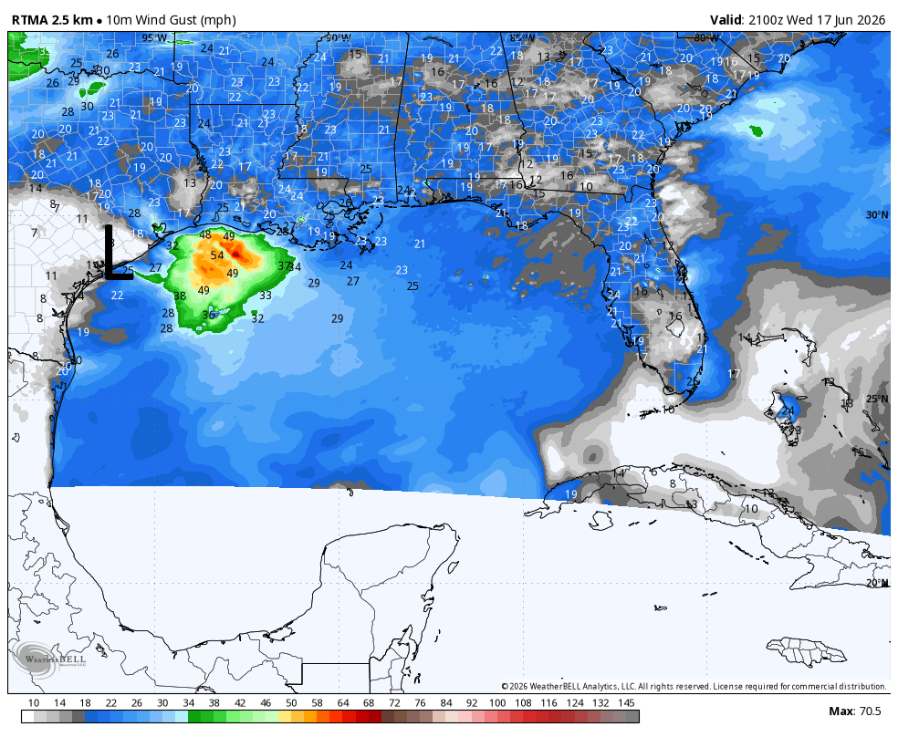
In the graphic below you can see that the winds in Bay City, where the “center” of Arthur was located at the time, were almost dead calm. And while there were some fairly strong wind gusts at the time associated with Arthur, they were a couple of hundred miles distant from the center of circulation.
The strongest wind gusts associated with Arthur are located well out over the Gulf on Wednesday evening. (Weather Bell)
This can happen with weak tropical systems that have fairly poor defined centers of circulation. But it made for an odd situation on Wednesday during which Arthur’s strongest winds came several hours before the center of the storm itself arrived. A similar phenomenon happened with its rains, which were even further removed from the center.
Anyway, Arthur has dissipated and we can all hope this is the only named storm that makes “landfall” in Texas this year.
Thursday
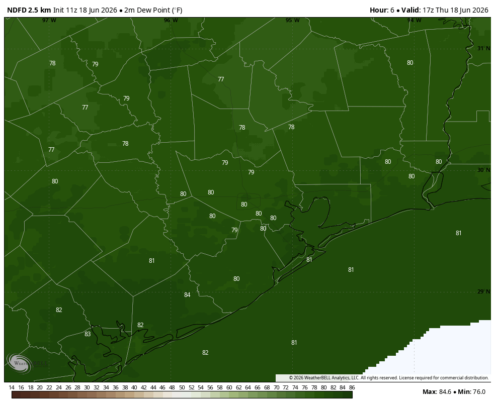
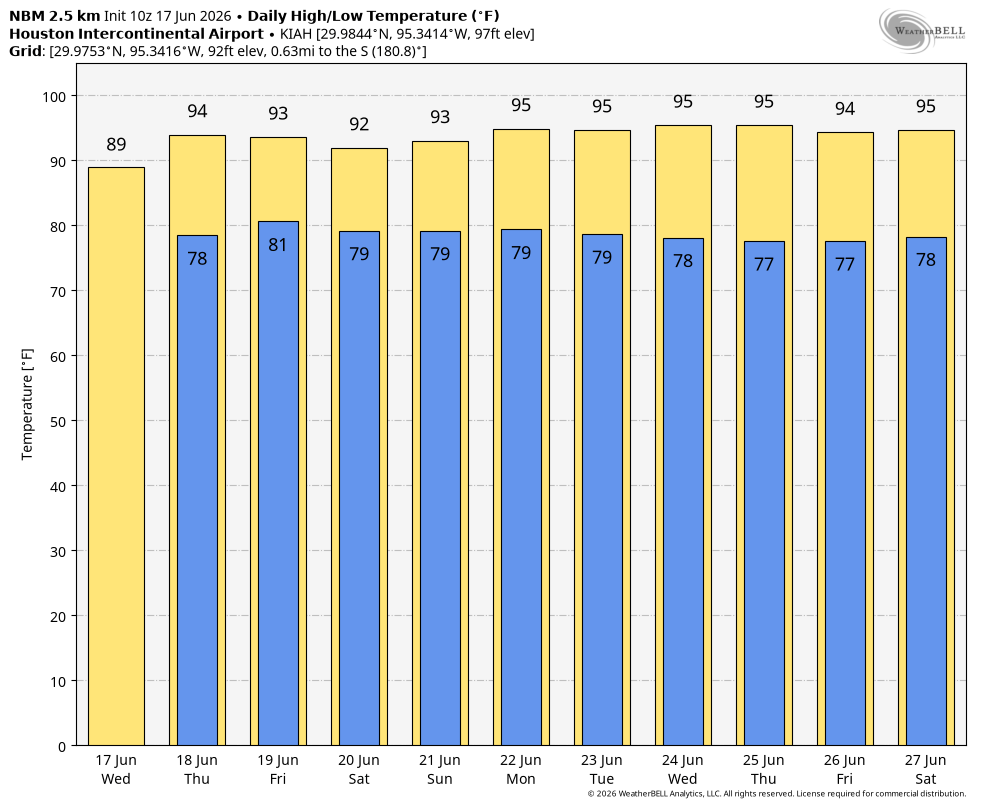
We’re going to see a much calmer day. Mostly cloudy skies this morning should give way to mostly sunny skies this afternoon, with high temperatures reaching the low- to mid-90s for most of the Houston metro area. With dewpoints near 80 degrees, the humidity will be something fierce. Winds will be from the south at about 10 mph today, gusting up to 20 mph this afternoon. Low temperatures tonight probably will not fall below 80 for most of the region, so prepare to sweat. Rain chances are basically zero.
With dewpoints around 80 degrees today, the air is going to be sticky with a capital ‘S.’ (Weather Bell)
Friday
This should be a similar day to Thursday in terms of temperatures and humidity. There may be a few more clouds in the sky. By Friday evening a weak front (it won’t make it to Houston) will be dropping down from north Texas. This could serve as a focus for some isolated showers and thunderstorms from Friday evening into Saturday.
Saturday and Sunday
I expect skies to be partly to mostly sunny this weekend, with high temperatures generally in the lower 90s. Where we have some uncertainty is in the rain department. The aforementioned dying front could generate some additional showers and thunderstorms on Saturday in the Houston region, perhaps most likely north of I-10. I would put overall rain chances at about 40 percent during the morning and daytime hours, but I don’t have supreme confidence in the forecast at this point. There is a higher likelihood of Sunday remaining rain free.
Next week
By the end of the weekend we should see high pressure taking control of our weather, and this will hold sway for much of next week. We are looking at a sustained stretch of sunny skies and high temperatures in the mid-90s. It won’t be peak summer by any means, but it will likely be the warmest period of weather so far this year for Houston. These temperatures will also coincide with some of the longest days of the year, so be sure and use Sun protection.
In brief: Just a short update to note the formation of the Atlantic season’s first named storm, Arthur, and what it means for Houston today. In short: rains ending, but the next several hours will be windy near the coast.
Meet Arthur, the first named storm of the 2026 Atlantic season. (NOAA)
Hello, Arthur
The Atlantic season’s first named storm, Arthur, has formed less than 100 miles from downtown Houston. Although that may sound concerning, we’re here to tell you it’s really not.
Our biggest concern from this system has been the potential for heavy rainfall, but that risk is now rapidly diminishing. The bulk of the precipitation from Arthur is falling well to the northeast of its center, and most of this is offshore. The scattered showers we are seeing across Houston as of 10 am CT on Wednesday will continue to diminish. We are likely to be rain free from the middle of today through Friday evening. For this reason we are ending our Stage 2 flood alert.
Arthur’s location, and forecast track, as of 10 am CT on Wednesday. (National Hurricane Center)
The biggest impact from Arthur is being felt right along the coast. Its sustained winds have been measured at 35 mph, or higher, along Galveston Island, with some gusts up to 50 mph. This has, frankly, exceeded our expectations. Even areas as far inland as Hobby Airport have recorded gusts up to about 30 mph. These winds should start to ease by this afternoon as the center of Arthur nears Galveston and starts to move away. After that we expect calm and sunny, albeit hot, conditions on Thursday and Friday.
We’ll have a full forecast for you, per usual, on Thursday morning.
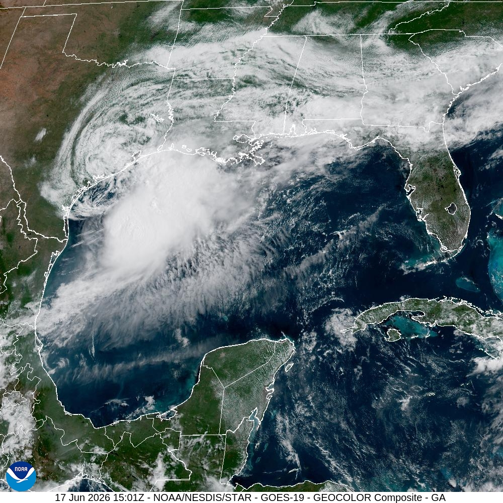
In brief: Central and southern parts of Houston are seeing rain from an approaching tropical system this morning, which should pass near Galveston Island later today. Winds should be mostly modest, and we expect rains over the Houston region to diminish by late morning or early afternoon.
Location of tropical system at 7 am CT. (National Hurricane Center)
Tropical update
As of 7 am CT a low pressure system lies just off the coast of Texas, near Matagorda Bay. According to the National Hurricane Center, it is moving to the northeast at about 7 mph and should continue to track more or less along the upper Texas coast today. This will bring its rather poorly defined center near Galveston Island sometime today, likely during the early afternoon hours. Although there remains a chance this system becomes a tropical depression or storm, whether it does so largely does not matter for the greater Houston region today as it passes by. The system’s effects are now essentially baked in.
Wednesday
Most of the Houston region saw a quiet night, but areas southeast of Houston, including Pearland, Clear Lake, and League City, picked up 2 to 3 inches of rainfall. Additional showers are now spreading into the Houston metro area this morning as the tropical system nears our region. These showers are likely to persist through the morning hours before lesser coverage this afternoon. Additional accumulations of 1 to 2 inches are possible, although most locations will see less than this. The impactful rains from this system are falling to the north and east of its center, so as the center moves near Galveston Island these rains should move on to east Texas and southern Louisiana.
Rain are located to the north and west of the low’s center. (RadarScope)
In terms of winds, coastal areas including Galveston Island could see winds pick up to 15 to 20 mph today as the center passes nearby, with some gusts up to 30 mph. Water levels may rise 1 to 3 feet above tide levels, so some minor coastal flooding is possible.
High temperatures today will be dependent upon rain coverage in your location, but should range between 85 and 90 degrees.
Thursday and Friday
These are likely to be partly to mostly sunny days with rain chances of 10 percent or less, allowing the soaked Houston region a good opportunity to dry out. Each day should have high temperatures in the lower 90s with a good deal of humidity. Nighttime lows will be very muggy, with air temperatures likely falling only to around 80 degrees.
Saturday and Sunday
A decent chance of rain, perhaps 40 or 50 percent, returns on Friday night or Saturday, but the day should still be partly sunny with highs in the vicinity of 90 degrees. I don’t have great confidence yet in Saturday’s rains, but these showers should be of the passing variety rather than something that persists for hours on end. Sunday looks to be mostly sunny with significantly lower rain chances. Expect highs in the lower 90s.
Temperatures next week will be more summer-like for Houston. (Weather Bell)
Next week
Most of next week looks warm and sunny, with highs in the low- to mid-90s. Temperatures have been cooler this week with the widespread showers. That likely will change next week as we experience more summer-like weather in Houston.