In brief: Today we discuss a bit about yesterday’s wider spread rain than expected in parts of the Houston area. A few additional storms are possible today before the heat parks itself back over Houston for much of next week.
Bertha recap
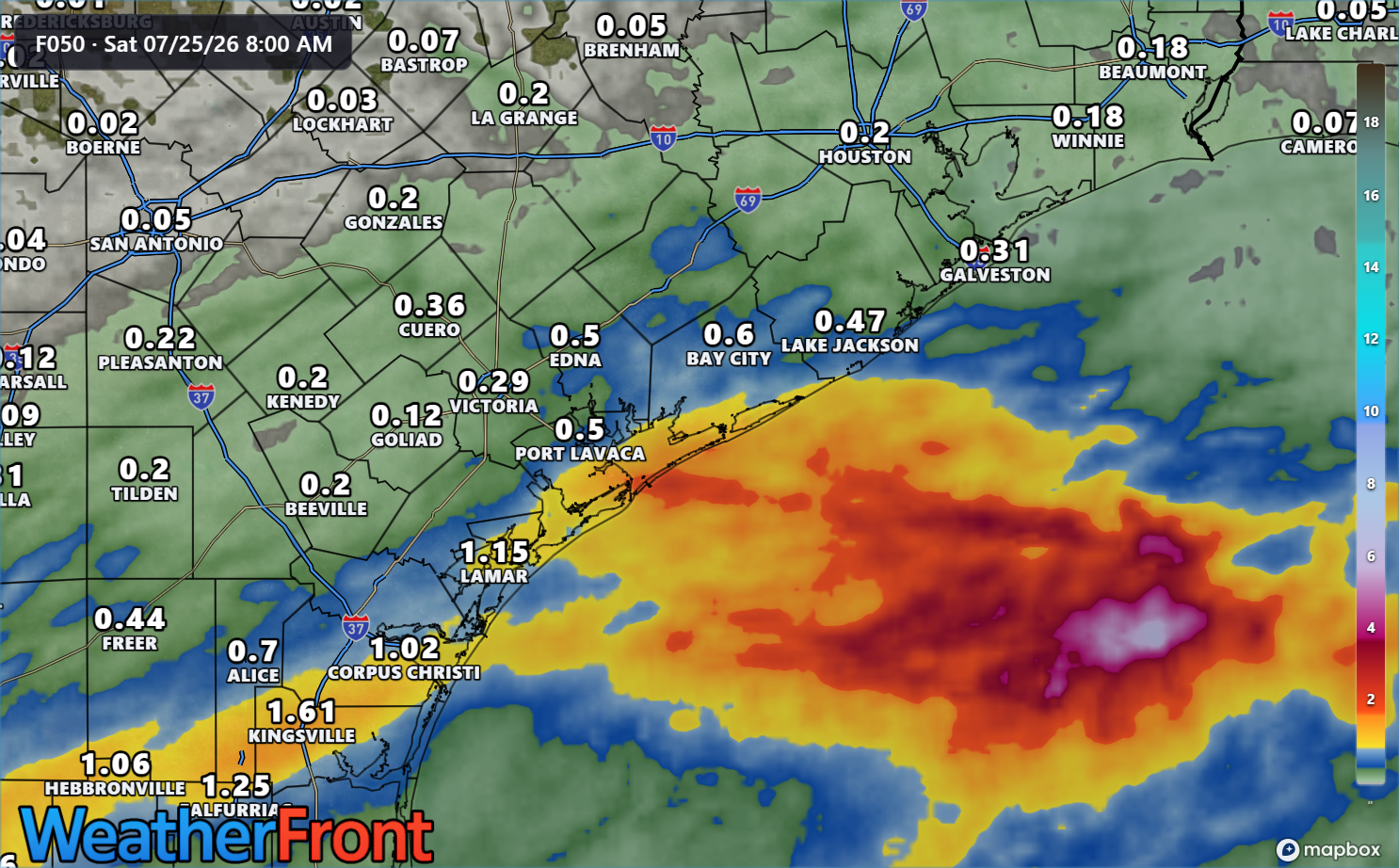
In terms of wind, Bertha was a nothingburger in Houston, as expected. In fact, I don’t believe any coastal location gusted much above 35 mph yesterday. In terms of rain, Bertha did overachieve in a chunk of the Houston area.
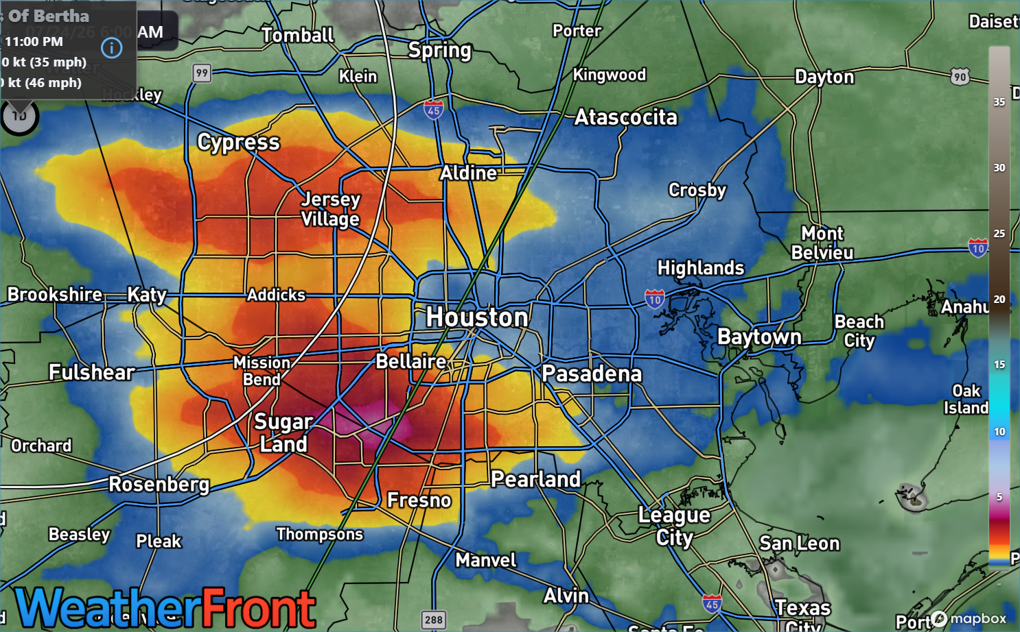
Purple/pink means about 4″+ of rain. (WeatherFront)
In Missouri City, several locations right along 90A picked up over 5 inches of rain which led to some rapid onset flash flooding. That extended back into Sugar Land as well. Meyerland saw about 3 inches of rain. Downtown Houston saw about 0.75″ of rain. In hindsight, while we mentioned that brief torrential rain was likely in spots yesterday afternoon, a Stage 1 flood alert probably would have worked best. It seemed as if the heaviest downpours would move fast enough to avoid that. Instead, everything congealed over Houston for a couple hours, and we got the above. While the tropical storm aspect of Bertha mostly did what was expected, the rain part remains a challenge.
Bertha’s remnants are passing southwest of San Antonio today, and they will continue through Mexico today and this weekend.
Today
A few showers or a thunderstorm are likely today across the area, with some onshore flow trailing Bertha. Atmospheric moisture levels are still pretty high, though decreasing. Still, that could mean again some locally heavy downpours this afternoon. Otherwise, look for highs in the mid-90s with sun and clouds.
Weekend
Saturday looks dry and hot with mid to upper 90s. Sunday should be similar, but there will be a slight tick up in available moisture for a few showers. So don’t be shocked to see that happen in a few spots.
(Weather Bell)
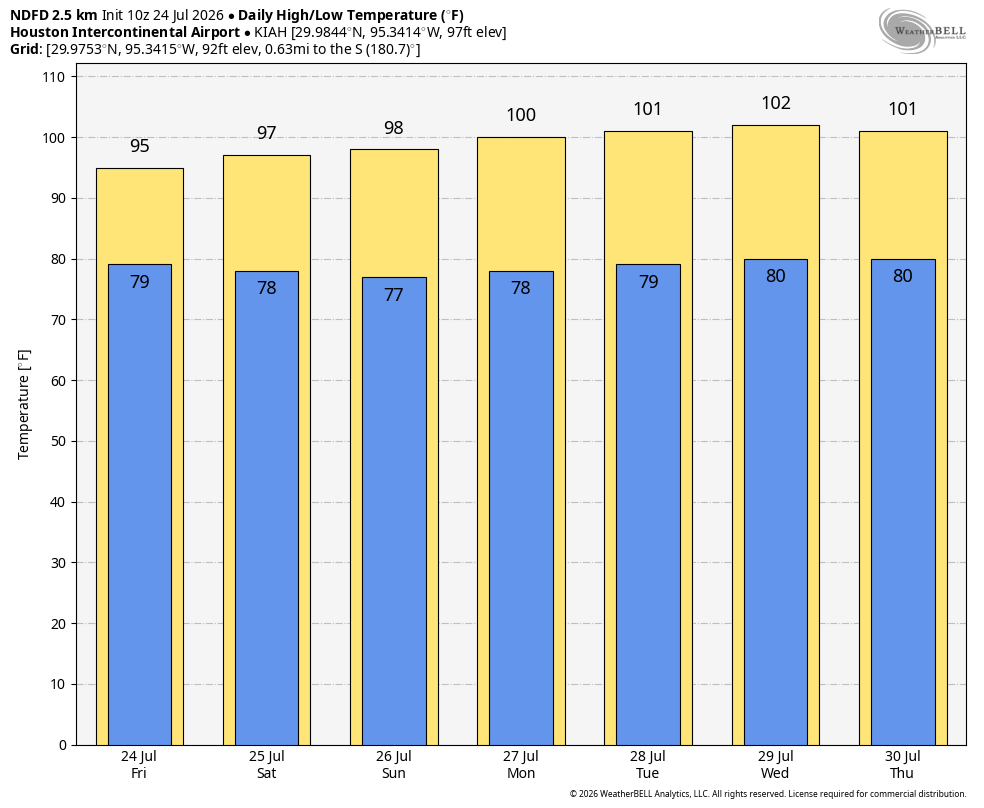
Next week
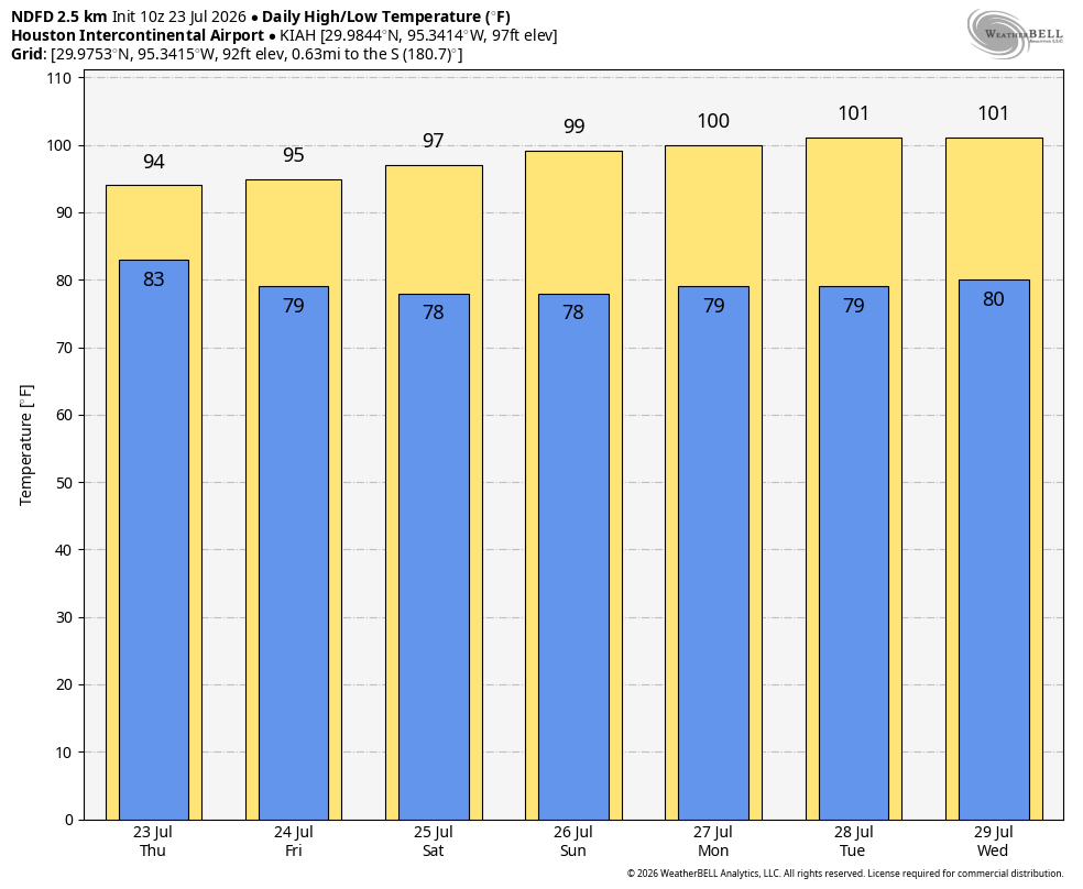
Temperatures are going to surge once again next week back to near 100 degrees. Wednesday or Thursday should be the peak day, with highs around 101 to 103 in Houston. Rain chances will be shelved for the most part through Wednesday, but a backdoor front, sort of like what we saw on this past Wednesday evening could try to sneak through and provide a chance of storms either Thursday or Friday evening.
Slightly “less hot” weather is likely after Wednesday or Thursday, but we’ll watch trends through the weekend and update you on Monday.
In brief: Watch for areas of flash flooding over the next few hours as Bertha’s downpours press through the Houston region. Stage 1 or low-end 2 type flooding is expected in the impacted areas.
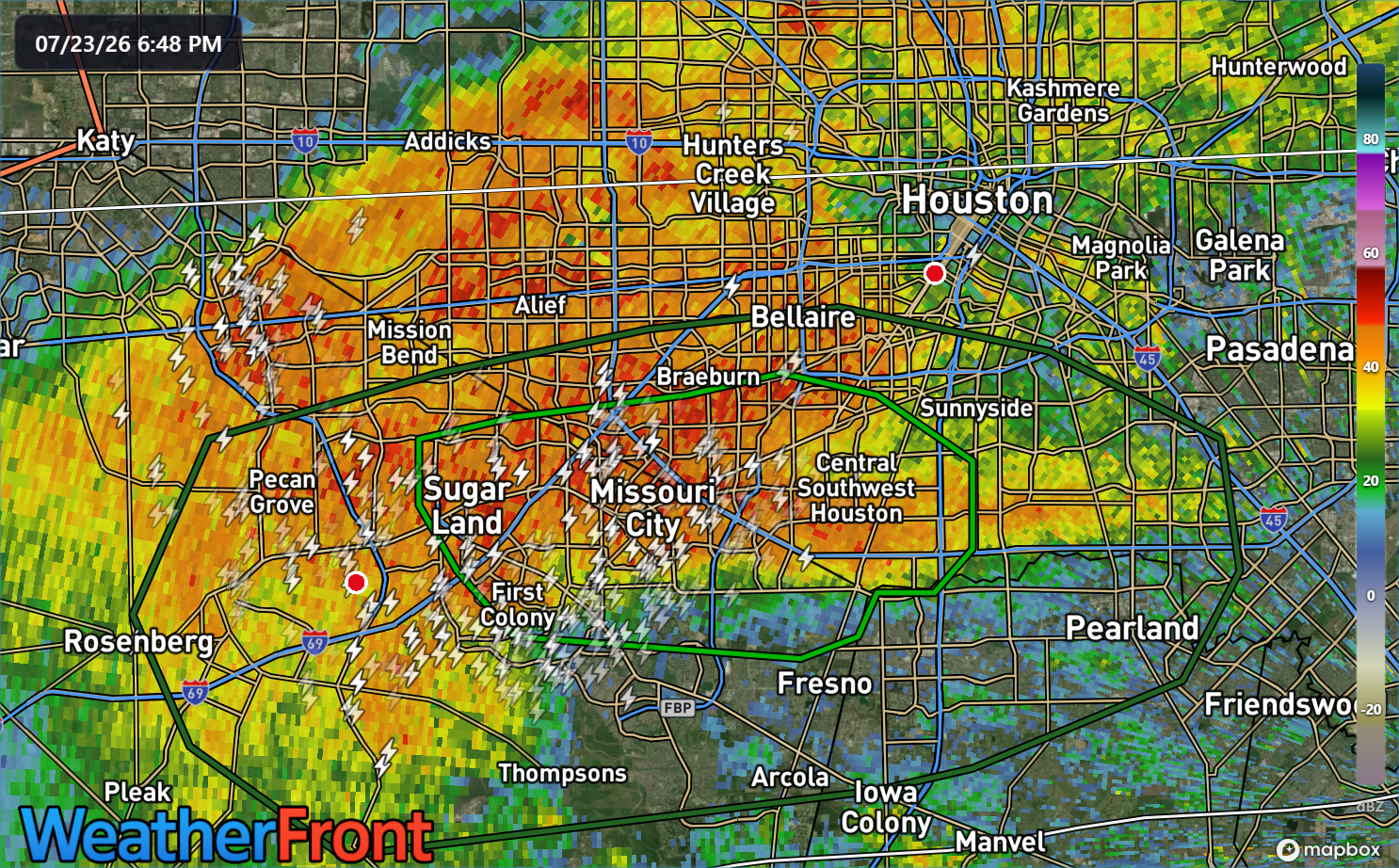
A flash flood warning is posted for portions of southwest Harris and Fort Bend County until 9 PM, as some bands of torrential downpours have pushed through the area. They are very slowly drifting north and west, but have dumped as much as 4 inches of rain over Missouri City in the last couple hours.
Radar image from about 5:45 PM CT on Thursday. (WeatherFront)
I would expect the flood advisory to eventually be expanded north and west as heavy downpours impact other parts of Harris and Fort Bend Counties, and another flash flood warning can’t be ruled out either. Watch for areas of street flooding over the next few hours, especially west of I-45. We should see storms and downpours peak over the next 2 to 3 hours and settle back down after 9 to 10 PM or so. Again, the core of the heaviest rain may slowly lift north and west, which should hopefully keep flooding from going beyond Stage 1 or perhaps low-end 2 in those areas.
Bertha itself has made landfall east of Houston and will continue off to the west or west southwest through the night and tomorrow.
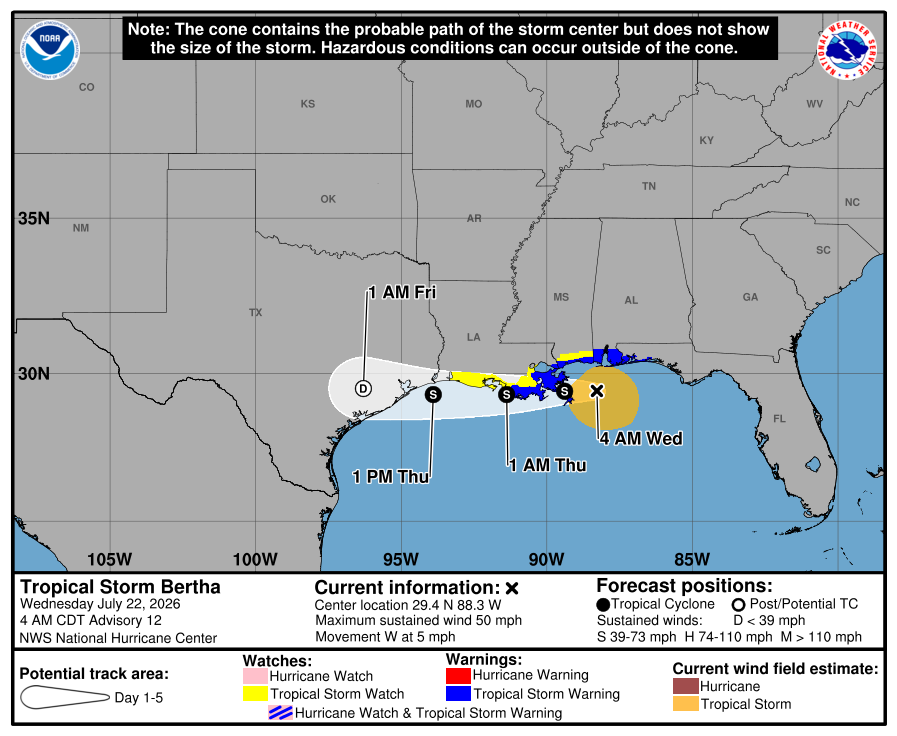
In brief: Tropical Storm Bertha will pass through Houston today with a chance of a few gusty, heavy downpours and some steadier rain well south of Houston or on the immediate coast. Overall impacts are expected to be minimal. The heat backs off some today before revving back up later this weekend and next week.
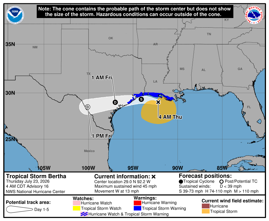
Tropical Storm Bertha
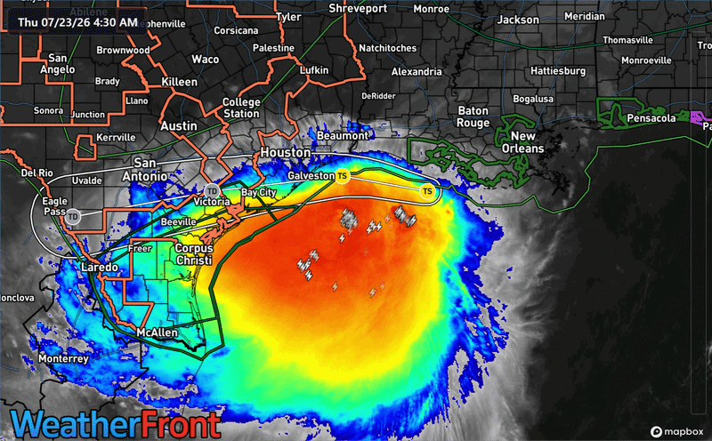
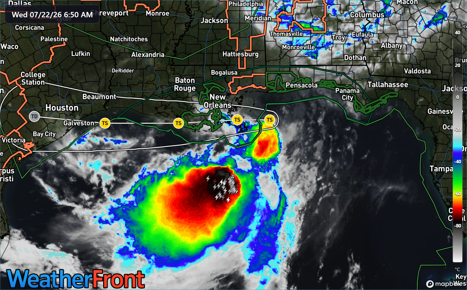
Bertha is holding steady this morning, which is to say it remains mostly a steadily moving rainstorm.
(WeatherFront)
You can see that the center of Bertha is hugging the Louisiana coast, while virtually all the storminess is displaced to the south and southwest well offshore. Bertha is not healthy but it’s a pretty blobby storm. Over the next 12 to 18 hours, the surface center of Bertha will move toward the Upper Texas coast, while the bulk of the rain moves toward Matagorda Bay and south or just falls over the open waters of the Gulf.
(NOAA/NHC)
Bertha will make landfall again in Texas, likely no stronger than it currently is, with maximum winds over water of 45 mph and likely a good bit less than that over land.
Impacts in the Houston area? We’ll see scattered gusty thunderstorms later this afternoon and evening, somewhat like we saw yesterday (a handful of CenterPoint weather sensors exceeded 60 mph near the Bay and Gulf). Any of those storms could briefly produce torrential rain and localized wind gusts of 40 to 60 mph (most people will not see that). In addition, some breezy conditions will occur on Galveston Island down through Freeport, with a few gusts of 35 to 45 mph possible. Tides will be slightly elevated and there could be some run up on beaches, though coastal flooding is expected to be very minor. Basically, this should be like any modest coastal storm we see throughout the year.
Forecast NBM model rainfall through Saturday. (WeatherFront)
Rain totals should not require even a Stage 1 flood alert on our flood scale today, but again just be aware that it could start pouring out of the blue at some point today.
On the positive side, cloud cover should hold temperatures down some after yesterday’s heat.
Today and Friday
We hit 102 degrees at both Bush and Hobby yesterday. (For those monitoring how close IAH is to reality, a CenterPoint sensor placed near the airport also measured 102 degrees). We will…not hit 102 degrees today. Look for highs back in the mid-90s today, especially north and west and upper 80s to low-90s south and east, closer to Bertha’s cloud deck.
Tomorrow should be a little hotter with Bertha passing inland to our southwest and declining. Look for mostly low to mid-90s.
Weekend
Saturday should be dry. Sunday should be dry for most too, though an isolated downpour can’t be ruled out. Temperatures inch upward here, back into the mid to upper-90s on Sunday.
(Weather Bell)
Next week
Up, up, up we go again. We should be back to near 100 on Monday or Tuesday. Temps may exceed 100 on Wednesday or Thursday before sliding back some next weekend. But it appears another good heat wave is coming next week. Rain chances may remain minimal through Friday.
In brief: Tropical Storm Bertha is slowly beginning to weaken this morning, with most of the modest rain from it likely to occur well south of Houston. In the meantime, heat is the story with 100s likely in Houston today, followed by scattered evening thunderstorms (not associated with Bertha). Rain chances are mainly south and near the coast tomorrow and diminish over the weekend, along with less hot weather.
Tropical Storm Bertha
Bertha is struggling this morning.
Tropical Storm Bertha is very disorganized. (WeatherFront)
The maximum winds have dropped back from 60 to 50 mph. The center is very close to the Louisiana coast, and all of Bertha’s thunderstorms remain offshore. Over the next couple days, Bertha should hug the coast and weaken further. Tropical Storm Watches are now posted on the immediate coast, which is what you would expect in this situation. Models are a bit split on Bertha’s future track, which ranges from the coastal hug to perhaps 100-200 miles offshore.
(NOAA/NHC)
The models are in very good agreement, however on Bertha continuing to weaken, regardless of whether the track is nearshore or offshore.
So wind is not a concern for us. The next question becomes rain. Most of the “core” rain from Bertha is displaced south of the storm’s center, so if you assume the track roughly follows I-10 or just south, most of that rain should continue to press toward the middle or lower Texas coast, or from about Freeport through Corpus Christi. That would actually be a good thing for the most part, as those areas have seen relatively less rain than other parts of the state.
For Houston, it will mean scattered thunderstorms at times, which we will discuss below.
Just as a note, I’ve seen comments on social media about, “Well, Allison. And Harvey was downplayed!” This is neither of those storms. Bertha will have neither the environment, the time, or the space to organize as Harvey did. And unlike an Allison or an Imelda, Bertha’s core is going to end up on the Pacific side of Mexico by later this weekend. In other words, it keeps moving. And for those concerned about Hill Country, there is currently no rain forecast over the next 5 days there. We get the anxiety, but we also want you to understand that this is not expected to cause significant problems.
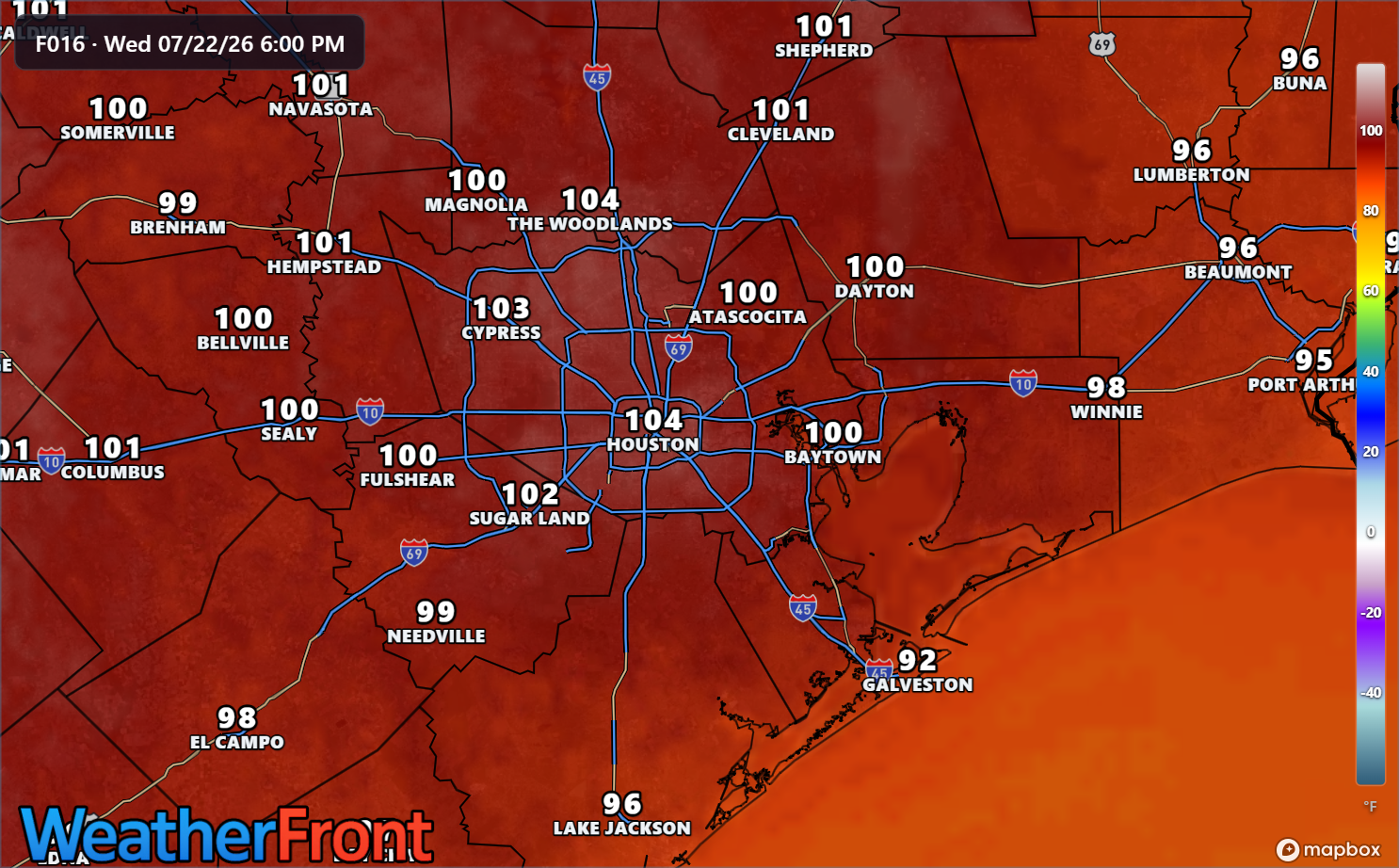
The heat!
Houston fell a tick short of our first 100 degree day yesterday, topping out at 99 degrees. A few isolated spots in the area did trip the 100 wire. Today should be the day, however. Temperatures are 3 degrees warmer this morning than they were yesterday. Northeasterly flow on the west side of Bertha will help give temperatures a jolt as well.
Heat blasts off today, with highs likely between 100 and 105 degrees. (WeatherFront)
Today is one of those days where it’s highly recommended to take it easy during the peak heat parts of the day. Temperatures should ease back a little bit tomorrow. Today has “hottest day of summer” vibes, though August is still to come so I won’t make a bold prediction. As always, our partners at Reliant have some good energy usage tips today.
A Message from Reliant
With Houston hitting 100 degrees, Reliant is sharing simple, cost-conscious tips to help Texans manage their energy use efficiently without sacrificing comfort. Here are the top three actionable tips to cut costs, stay cool and conserve energy:
Follow the “four-by-four” principle. Set your thermostat four degrees higher when you’re away from home for more than four hours to reduce electricity usage and costs.
Avoid using heat-producing appliances like the clothes dryer, dishwasher or oven during the hottest times of day. The most ideal time to run those is in the early morning.
Close blinds and shades on sunny days to prevent heat buildup and get the most out of the cool air coming from the AC.
More energy-saving and conservation tips from Reliant can be found here!
As always, thank you to Reliant for sponsoring our site and being such good partners with us over the years.
Temperatures will be in the mid to upper 90s tomorrow through Sunday (much cooler near the coast tomorrow) and then perhaps push 100 degrees again next week.
Rain chances
Let’s jump into storm chances real quick, with Bertha approaching.
Today
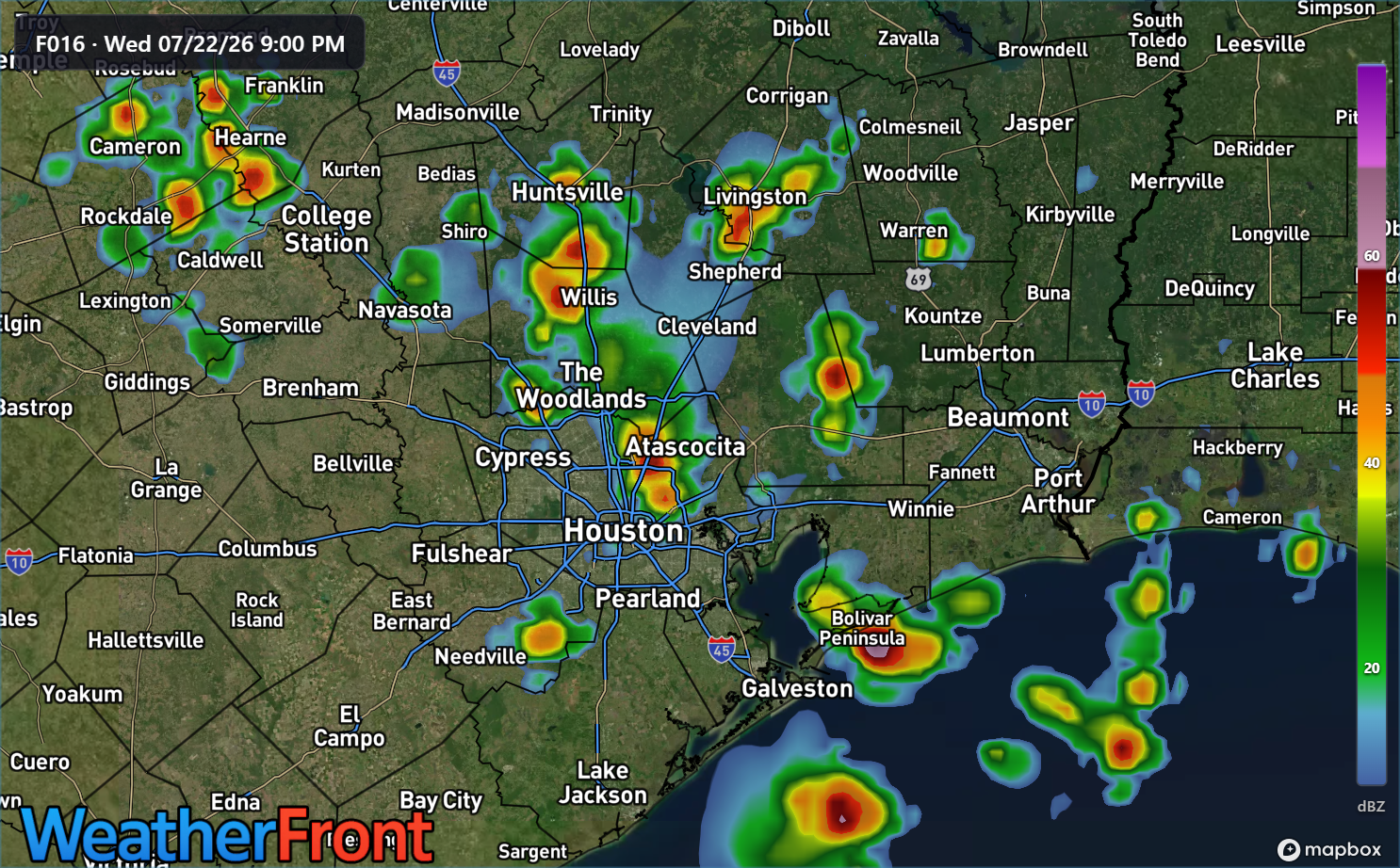
First off, today’s storm chances will not be from the outer bands of Bertha. With northeast flow kicking up, there is a weak “backdoor” boundary coming out of Louisiana and into southeast Texas. As this encounters the extremely hot weather over the area, it is likely a smattering of thunderstorms will bulk up, moving northeast to southwest across the Houston area this evening.
A forecast radar from the HRRR model for 8 PM this evening. (WeatherFront)
Northeast to southwest moving storms like this in the Houston area have a bit of a unique “personality” to them. They tend to be later bloomers. They tend to hold their intensity into the evening hours after sunset. And they can be locally strong. Storms may continue past midnight along the coast or well south of Houston.
Thursday
Tomorrow’s storm chances will probably be near the coast mostly, as Bertha’s southern flank approaches. This is where we could see some locally heavy downpours or just a steady rain, from Galveston through Matagorda Bay. The heaviest rain tomorrow and tomorrow night may go in south of Freeport. Rain totals are expected to be perhaps up to an inch on the coast, less inland and 1 to 3 inches south of Freeport.
Friday through Sunday
At this point, nothing worse than a few isolated storms are possible Friday into the weekend.
At this point, we don’t believe we’ll issue a Stage 1 or 2 flood alert, but we’ll keep an eye on things and adjust that posture if need be.