Summary: A very quiet Easter weekend is expected, with the most annoying weather element likely to be the breeze each day. Our next front arrives early Tuesday after a very warm Monday. It will bring a few showers but nothing too bad, followed up by quiet, pleasant weather later next week.
Is hurricane season really going to be that bad?
Over at The Eyewall, I’ve posted roughly once a month about hurricane season since January. I’m just basically tracking the status of El Niño and Atlantic water temperatures. We’re in the middle of a rather unprecedented global marine heat wave right now. The global oceans hit a record high temperature last month, and we’ve essentially set new daily records for the last full year, every day. It’s not just El Niño. That’s not hurting things, but it does not explain everything. We’ll cover this more at The Eyewall over time, but suffice to say, the Atlantic is one of many bodies of water that is blistering warm for March.
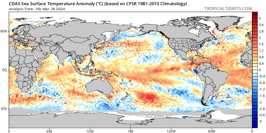
In fact, Atlantic Ocean water temps are already at levels you would typically see in early June. In our posts at The Eyewall, I’ve basically said that you can expect seasonal hurricane forecasts to come surging out of the gate this year. They are going to be calling for active, if not hyperactive levels of activity. They’re going to be ugly. No two ways about it.
The first major entrant in this derby, AccuWeather came out on Wednesday, stating that they expect 20 to 25 named storms and 8 to 12 hurricanes. Because that’s not enough, they framed the season as likely being “explosive.” AccuWeather also highlighted the western Gulf, Florida, and Carolinas for above average activity. In my post yesterday at The Eyewall, I did note that they got their landfall points correct in 2023, but they also missed a couple areas. In 2022 they said the Gulf Coast between Texas and the Florida Panhandle was at greatest risk, as were the Carolinas. There were virtually no major impacts in those areas that season, with Hurricane Ian instead ramming the southwest coast of Florida. This is a long way of me saying that seasonal landfall forecasts have extremely mixed results, so take them all with a grain of salt.
The next major entrant should be Colorado State University, which unveils their outlook late next week at the National Tropical Weather Conference in South Padre.
Obviously, all this elicits a lot of concern from people. We’ve heard from people asking about how worried they should be this year. Others are already using gallows humor to cope already. I think it’s important to say a couple things here. First, as an individual or family, you shouldn’t use a seasonal hurricane forecast as the basis for your preparation. You should prepare the same way each year for hurricane season: Evacuation plans, contingency plans regarding work, pets, and childcare, emergency kits, flood insurance, H-E-B cocoa granola in my case. For you, me, and the lamp post, honestly, seasonal hurricane forecasts are noise, scientific exercises that really don’t tell us anything seriously actionable. Sure, many of us like to know what they say, but in terms of what they actually mean, it’s very little. For governments and businesses, it’s another matter. Second, an active season does not always mean an active season — for Texas. Last year was active. Texas had Tropical Storm Harold, which was probably more beneficial than destructive for the southern part of the state. But aside from that, it was quiet. 1983 was a virtually silent hurricane season overall, except for Hurricane Alicia here in Houston which would easily be a 10 to 20 billion dollar storm today. So, active or quiet, we should prep each year.
Basically, do what you want with seasonal hurricane forecasts. But look, the reality is we live in a hurricane prone location. We accept that fact by living here. So, do what you can to prepare early in case this is the year. And if it’s not, well good for us. But please try not to lose sleep over these forecasts. There’s going to be a lot of noise over the next 2 months in the run up to the season. You’re best served using the time to prepare in case it does end up being our year.
On to the weather.
Today through Easter Sunday
The good news is that travel looks great all weekend. There should be no serious issues. There will likely be some patchy fog on a couple mornings. Aside from that and a breeze each day, especially on Sunday, it looks good. I do think some folks may find the breeze to be a bit much at times. Onshore flow really kicks in this weekend, sending our high temperatures into upper-70s today and 80s tomorrow and Easter Sunday. Morning lows will be in the low-60s tomorrow and mid-60s Sunday.
Rain chances should be close to zero all weekend.
Early next week
Our next cold front is targeting Tuesday. No joke, we’ll probably see one of our warmest days of the year so far on Monday, with highs well into the mid-80s. The number to beat is 89° that we reached on March 5th.
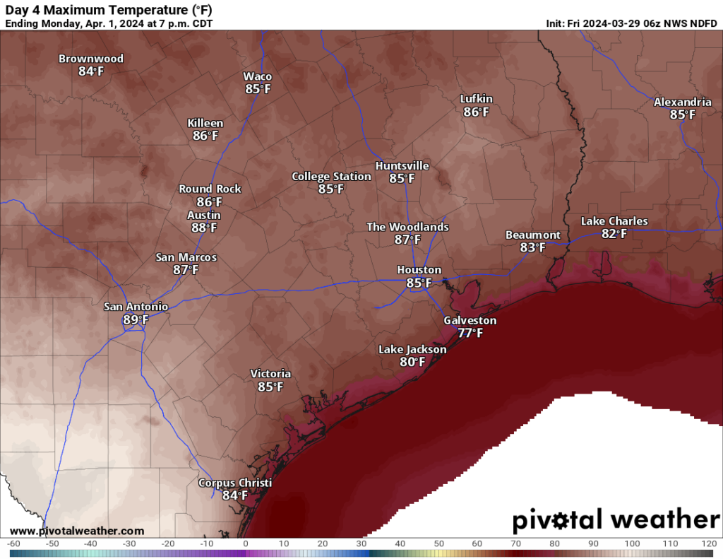
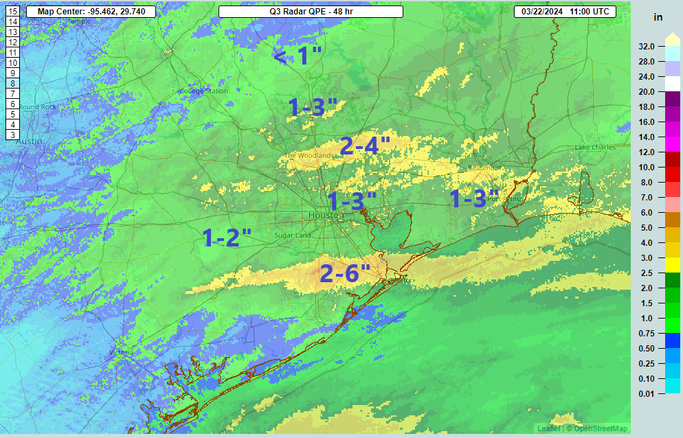
That will precede a frontal passage on Tuesday morning-ish. This front looks no worse right now than the one we had on Monday that brought some downpours and thunder for a short time. Rain totals look modest. That will usher in cooler, drier, nice weather for later next week. Expect lows to probably bottom out in the 50s for a couple pleasant mornings Wednesday and Thursday.
We’ll have the very latest on the forecast for April 8th’s eclipse on Monday. Not a whole lot has changed today, so let’s see what the weekend does, and then we can really dig in on this hard next week.