We are heading back to being mired in a weather pattern that is generally low impact (aside from some fog) but also fairly obnoxious: Lots of clouds, cold fronts that will shift temperatures in a big way depending on where they’re situated, and plenty of rain chances but ultimately not a lot of rain accumulation. Let’s dive in.
Today
Areas of fog, locally dense, have developed this morning, and there is a Dense Fog Advisory through 9 AM for most of the area. Give yourself a couple extra minutes out the door today. As fog lifts, expect a good deal of cloud cover this morning, giving way to some partial afternoon sunshine at times. High temperatures today will be contingent on sunshine. With a lot of sun, we could make a run for 80° in spots, particularly west of I-45. With clouds hanging on, expect upper-70s in most places. Some fog may roll back into coastal communities later this afternoon.
Saturday
The forecast for tomorrow is tricky. The first in a series of cold fronts will get down to about US-59 in the morning.
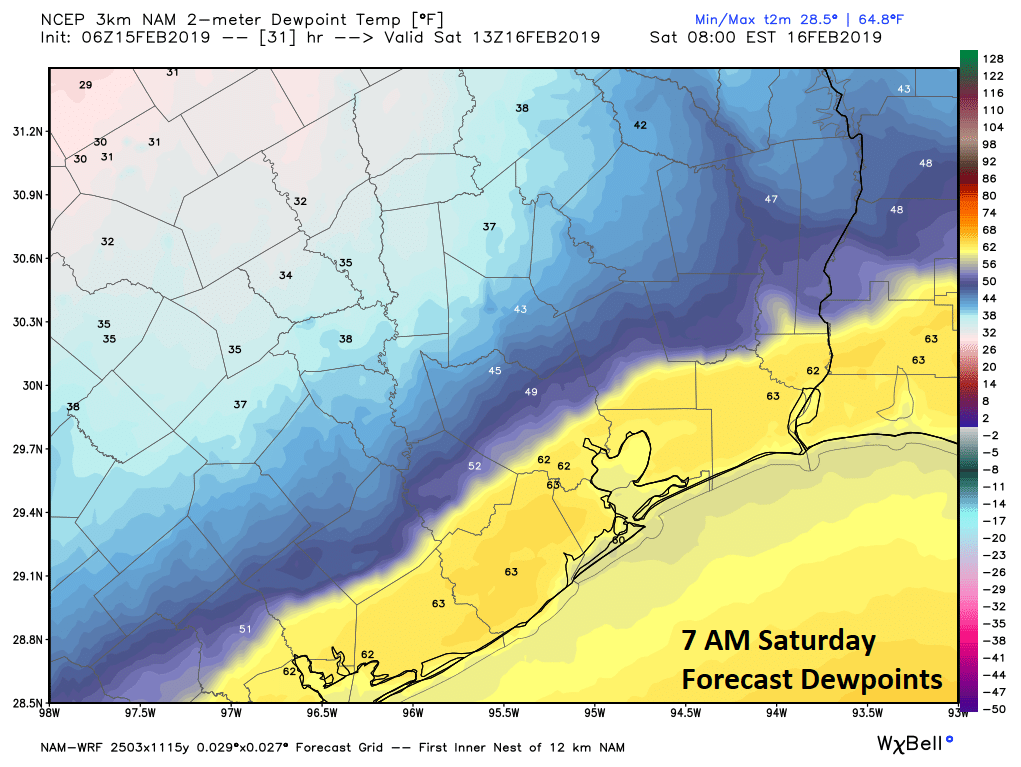
Using the image above (which shows dewpoints instead of air temperatures), you can see the cold front is conveniently right along US-59. This is from the NAM model, which is probably the most aggressive of the models in bringing this front south. In fact, this may even be a smidge too far south and east. But I want to show you how sharp a cutoff this is between very warm humid and potentially cooler and drier.
The front will likely make limited progress south and may even begin to retreat a bit back to the north in the afternoon. Ahead of the front, we will see areas of dense fog along the coast or in the bays once again for much of tomorrow. Temperatures will likely be in the 70s to perhaps near 80° again. North and west of Houston closer to the front in the afternoon, look for mid-70s. There is a small degree of uncertainty tomorrow. If the front is able to be aggressive and dives southeast enough, some areas north or west of US-59 may only see highs in the 60s Saturday.
The good news is that rain chances look limited on Saturday. There may be a few showers or sprinkles along the coast, but otherwise, it just looks mostly cloudy tomorrow (foggy along the coast).

Sunday
Regardless of what happens tomorrow, onshore flow should increase on Sunday again. We could be dealing with sea fog again on Sunday morning or even into the afternoon along the coast. Elsewhere, it will be mostly cloudy. Look for high temperatures to get into the 70s Sunday. That should occur before yet another cold front approaches the region. This one will carry a chance of showers as it approaches and should get farther south and east.
But it won’t be fast. The front is going to begin to drag its feet as it approaches the coast. The problem again is that there will be a sharp divide between winter on one side and spring on the other. In addition, if the front stalls out nearby, there will likely be continued shower chances into Sunday night and Monday.
So we’ve got a lot to sort out with this, but the bottom line is this:
- If you have outdoor plans this weekend, you’re probably fine on Saturday, but be prepared for a sudden change to cooler weather, especially north or west of US-59.
- If you have outdoor plans on Sunday, there will be a good chance of light rain or showers, especially in the afternoon. I can’t promise a dry morning, but the odds are higher for rain in the afternoon.
- Like Saturday, the placement and speed of the front will determine if we can slip back into the 50s or low 60s later in the day or remain in the upper-60s and 70s through the late afternoon.
Next week
Sitting here this morning, I feel confident that a final cold front will push through on Monday, ushering us back into more of a late winter type pattern of clouds, light rain or shower chances, and temperatures in the 50s. However, there are some signs that the front may not get that far east of Houston, so it’s possible we’re dealing with some changes in temperatures next week. We’ll iron out the details for you on Monday, because as of right now, I don’t have confidence in those details. At all. Right now, I would say expect 50s or low-60s during the day and 40s or low-50s at night with clouds and showers possible each day through Thursday. Again, this could change.
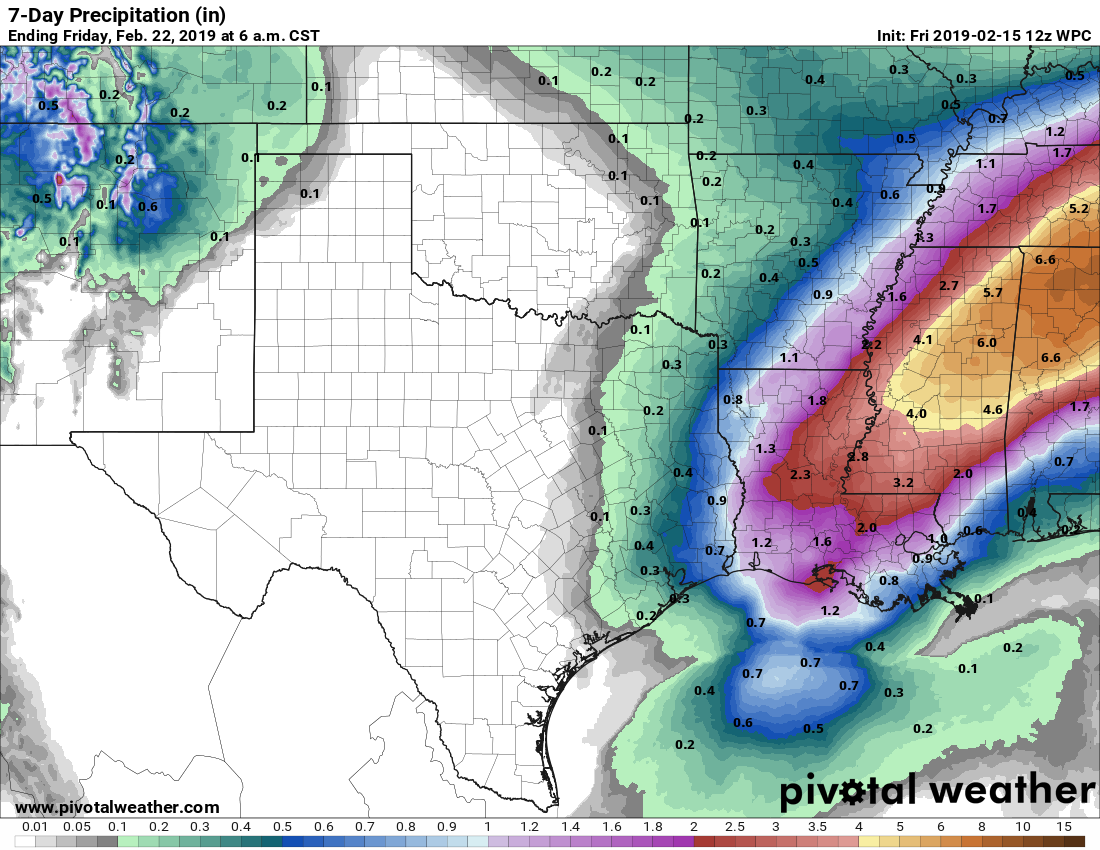
In terms of total rainfall through next week, given that we have rain chances almost every day Sunday through Thursday, we really don’t expect much. Most areas should see under an inch, and many will probably see under a half-inch. If we do see heavier showers and higher totals, though would likely be south and east of Houston. Eric will have the latest on this annoyingly low confidence forecast period on Monday morning.
Well, I put my plants out already, so I am banking that winter is over (below 45 anyway) along the coast.
I’m personally going to say its tomato time!
Those dreaded words…”a final cold front”
HA…fortunately I don’t think that’s the last cold front we’ll see. Some signals we may end up cooler than average late February and early March are showing up, so we’ll see.
Fingers crossed that cookoff weekend looks nice 🤞🏼