Summary: A hard freeze is likely north of Houston tonight, while much of the area sees 20s for lows. A light freeze is possible tomorrow night before we warm up. Next week’s rain chances are coming into better focus, with Monday and perhaps Wednesday seeing the most rain, but chances persisting all week long. Localized flooding is something we’ll be watching for, but we’re hopeful the rain is spread out over a long enough period to avoid anything too serious. We’ll have another update on this by Sunday.
Today & Saturday
We’re back at it today, with gusty winds and chilly temperatures, as a second plunge of cold air descends on Texas. This one is much more moderate than the one we saw earlier this week, but still after yesterday’s mid-60s, today’s blustery 40s will feel cold. But, we have the sun, so that counts for something. Winds will be 15 to 25 mph, with gusts to 30 mph, stronger over the water.
In terms of tonight’s freeze, as winds settle and skies remain clear, temps should drop efficiently into the 20s virtually everywhere away from the coast. For the city of Houston and most areas south or east, this will be a light freeze. Northern and western outlying areas are at risk for a brief hard freeze tonight, with lows expected in the mid-20s for The Woodlands, Conroe*, and Brenham. (*Conroe is always an interesting case given that they consistently record the coldest temps in the region, likely due to the location of the airport. So it’s possible they dip into the upper teens tonight)
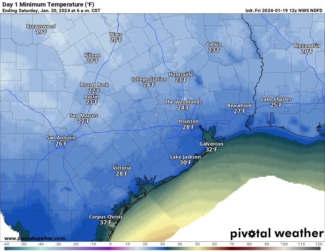
This will still be about 6 to 10 degrees milder than the hard freeze earlier this week but certainly still capable of hazards to exposed plants (and pets).
Saturday will be breezy and chilly but a little less harsh than Friday. We should see highs in the mid to upper-40s with breezes of 10 to 15 mph or a bit gustier at times. Expect sunshine as well.
Sunday
Expect one more risk of a freeze Sunday morning, mainly north and northeast of Houston. A hard freeze is unlikely anywhere in our area. We will see increasing clouds with a chance of a few showers as early as Sunday afternoon, as high temperatures slow-climb into the low-50s (40s again north).
Next week
The rain we expect next week continues to show up in the forecast rather substantially. We’re starting to hone in on when the worst of it may be now. It looks like we have one pretty strong disturbance that moves through the area on Monday, which should mean numerous to widespread showers and thunderstorms.
This could deliver us anywhere from 1 to 4 inches of rain, and locally higher amounts can’t be ruled out. I would probably say the highest totals may fall to the south and east of Houston, but that is a very low confidence forecast call right now.
Tuesday should see isolated to scattered showers and storms. Rainfall should be a bit more erratic here, with some places seeing a quarter-inch or less and others another 1 to 2 inches perhaps. Then Wednesday may see another strong disturbance with the potential for at least another 1 to 2 inches over a broad area, with higher amounts.
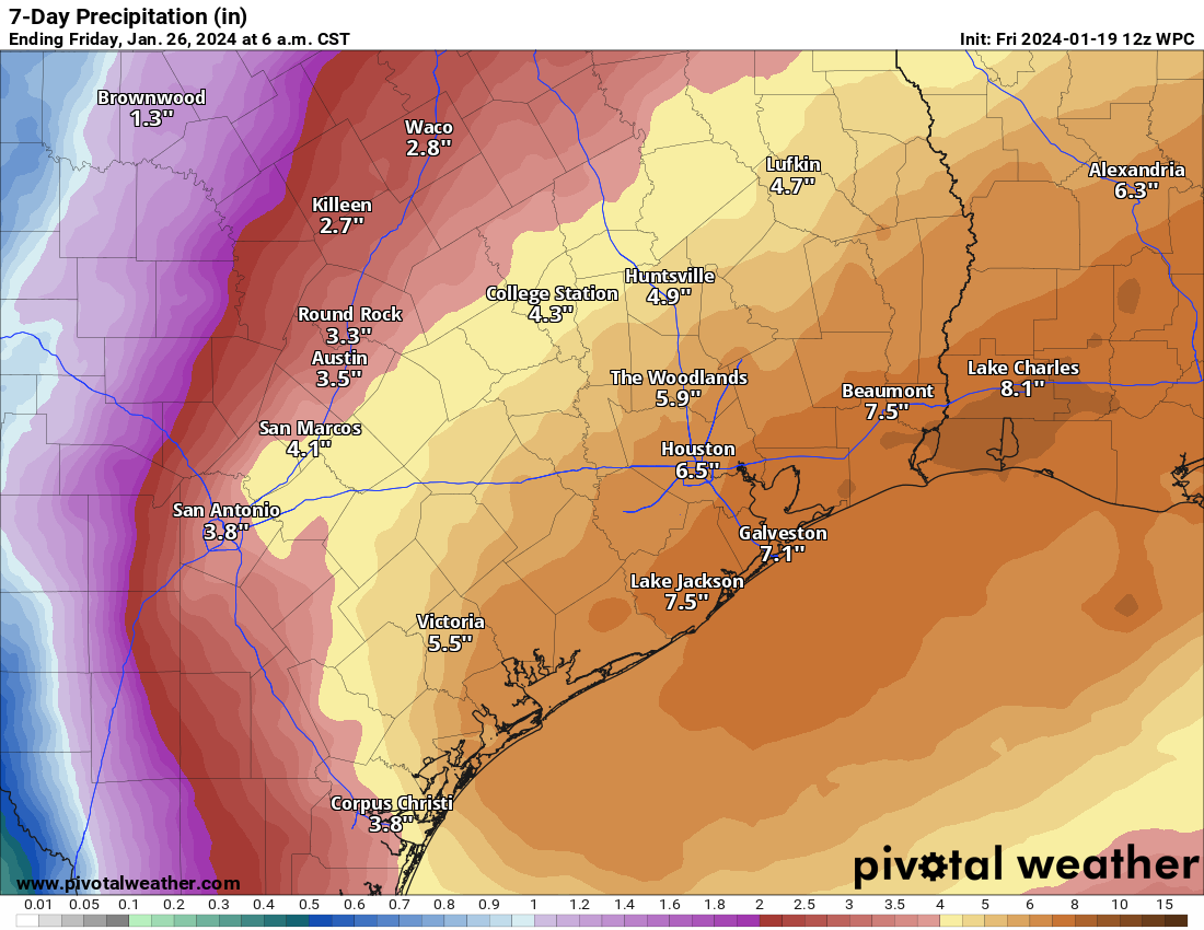
Additional shower chances will follow Thursday and Friday, but it’s tough to say what those look like right now. When all is said and done, the rainfall amounts will tally 3 to 8 inches by Thursday, with higher amounts possible.
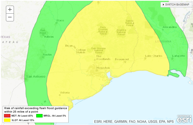
Does this mean flooding? It may. With the ground rather firm after this week’s freeze and the subsequent one this weekend, a lot of this water will be quick to run off, which means ponding and street flooding are a good bet in the usual trouble spots. The hope is that the total rainfall will be spread out over a long enough period with enough breaks in between that we avoid any more serious flooding, but it’s something we’ll continue to monitor this weekend. We’re going to especially watch to see how watersheds like Cypress Creek, Spring Creek, the San Jacinto River, and other slower responding basins handle this. This will also impact the Beaumont and Lake Charles areas to some extent. Which location wins the rainfall derby is still TBD.
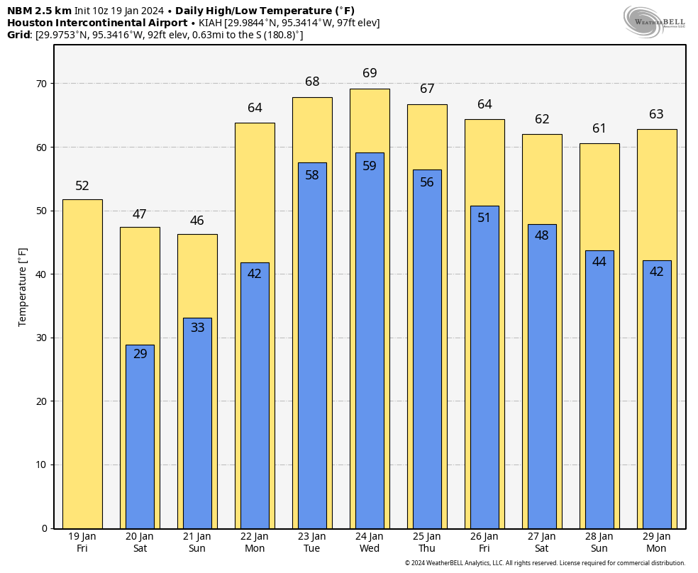
What about temperatures, you ask? We should see high temperatures well into the 60s most of next week with lows generally in the 50s to low-60s. This may also lead to periods of sea fog on Galveston Island, Bolivar, and along the bays. Maybe some cooler weather resumes by next weekend.
We will have another update for you by Sunday regarding Monday and next week’s rainfall, and I expect we will be implementing our flood scale then as well.


From the freezer into the swimming pool. Gotta love it. Nope.
How about some boring weather for a change?
What a fun week!!! Rain, rain, rain!!!
Deep freeze this week, flooding next week. How about record heat the week of the 29th to complete the Houston Trifecta?
“It’s called winter and spring!!!!!!”
I was told when I moved here that Houston has 2 seasons: January and summer. This has pretty much been the case since I arrived 5 years ago.
Meh. 5 months too late for all that rain.
Taking the long view, the worst Texas cold snap occurred in 1899. According to weather. gov:
“In February 1899, a two-week period of exception- ally cold weather culminated in what weather historian David Ludlum (1970) describes as “the greatest Arctic outbreak in history.” Temperatures fell to 0°F (-18°C) along the beaches of the Gulf Coast and ice flowed from the mouth of the Mississippi River into the Gulf …”
Significant arctic blasts also occurred in the 1920s, 1930s and 1940s. In the 1800s the freezes of 1864 and 1867 were also severe. My favorite report is that of Dutch immigrants using their ice skates on the Sabine Pass channel.
I came here from SLC. Utah at end of 1997. But I was coming to Houston for business starting about end of 1984. This cold down here, while a mess, is nothing compared to what other parts of the country see every winter.
I remember some stretches in SLC that were dreadful. One in particular was one period of about 35 days where the HIGH was around zero F and the overnight Lows were in the -15 F range; in winter 1995/1996. The water line into my house was buried 36″ below grade and even we had to dribble water then. Some houses had the water line come up into an unheated garage. And those folks had the line freeze right there unless they were insulated.
I also remember one stretch where the dreaded inversion settled over the SLC Valley, and people in the downtown did not see the sun for over 60 days. Every day the fog layer got thicker, and it was dense from about 4320′ to 5300′ elevation. Down in the fog, the air was 20 F day and night. Above the fog was 40s for the high with bright sunshine and 20s for the low. We used to drive up one of the canyons to get up into sunny skies.
We lived in Connecticut for a couple of years which is all we could take of the cold and snow. Black ice claimed a car I was driving over the Connecticut river. Horrible stuff.
Yep the one in 1899 was so cold that parts of the Galveston Bay close to shore actually froze.
This forecast doesnt sound so great, a little cold, but still the punishing winds continue, and then a chance of rain most every day next week, some days likely getting a good dose of rain.
They should also have a post that mentions that the carbon levels in the air have never been as low as they are today. If people weren’t burning fossil fuels and putting carbon back into the air, plants wouldn’t be around, because, the carbon dioxide is their food that they use to synthesize sugars.
I used to think you were just a terribly misinformed person, but this is so asinine that I suspect you are just a VERY committed troll. Not only is the CO2 concentration in the atmosphere at about 422ppm right now (which is almost 150ppm higher than the pre-industrial level), but plants also managed to grow back then. In fact plants survived through the Ice Ages when CO2 in the atmosphere was around 185ppm.
Do you think plants only came into existence because we started burning fossil fuels?
It’s impressive that you can pack so much wrongness into one post. What you said about carbon levels is completely wrong, and you could have verified that with 15 seconds of research. What you’ve said about plans is so absolutely astoundingly dumb that I’m a little concerned about your mental health. Do you truly believe that “plants wouldn’t be around” if people weren’t “burning fossil fuels”? Because if so, not only are you wrong, but you are also fantastically stupid.
No, there is not so much wrongness. If you are talking about carbon dioxide levels in the last 100 years or 1000 years, they have increased. But in the time of the dinosaurs and all that, levels were much higher, and the planet was much warmer. I’m sorry for informing you that the earth is more than 500 years old.
Right, so, fantastically stupid. Or an excellent troll!
Oh look, it’s Jason again! The propaganda snorting lunatic who thinks global warming is fake because his overlords tell him that’s what he needs to believe so they can get richer off his sheep-attitude. Wake up dude. We are killing our planet.
Thank you for these forecasts. Do you have any longrange outlook for February? May be traveling across Texas. I10 Katy to ElPaso.
I’m already on your email list. Brandee Standley
I’m hoping for balmy weather for Fredericksburg mid Feb. I want to cycle a few routes around there for a couple of days – so let’s put our order in now to be sure we get what we want.
I am late in saying so, but thank you for your coverage during the freeze earlier this week. I always appreciate your updates, whether the weather is giving us all trouble or not. You are my go-to weathermen.
About Conroe, why does the airport make Conroe’s temperature colder than the rest of us???
Linda
Y’all should remember that the City of Houston extends pretty far north, including Kingwood and the Willowbrook Mall area. Those areas have a forecast low of 26 degrees tonight and a hard freeze is certainly possible.
Ok, I read this article and literally the only thing I can think about is why an airport would make an entire city cold?
The Conroe airport is located in a clear open area with probably not very many trees. Plain open land reflects the suns warmth back into space easier. Areas with alot of trees helps hold heat in better at the surface. Also urban areas with alot of concrete and buildings retain alot of the daytime heating. The actual inner city of Conroe is probably several degrees warmer at night than the airport. That’s my best guess.
Space City Weather is Absolutely Awesome!!!
I hame more confidence in you than our local TV weather reports!!!
Keep up the Great Work!!!