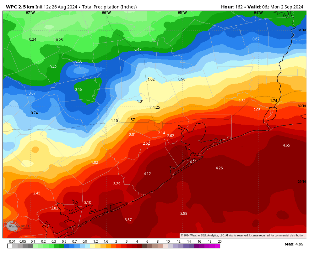
In brief: After a long, hot August the Houston region’s pattern will change significantly this week. In the absence of high pressure we’ll see significant daily rain chances and lower temperatures. Rain accumulations will be greatest near the coast, but even inland locations may pick up an inch or more of rainfall.
Up until this past weekend, Houston has largely been beneath a potent high pressure ridge this month. It has not been directly centered over the region, which is why daily high temperatures have not been as blistering hot as the summer of 2023. But our daily high this month has nonetheless averaged 98 degrees, with a total of eight days reaching 100 degrees or higher. Additionally, we have recorded almost no rainfall. Much of the region has received 0.5 inch, or less, for the entire month of August. It’s not for nothing that I believe August is by far the worst month of the year for Houston.
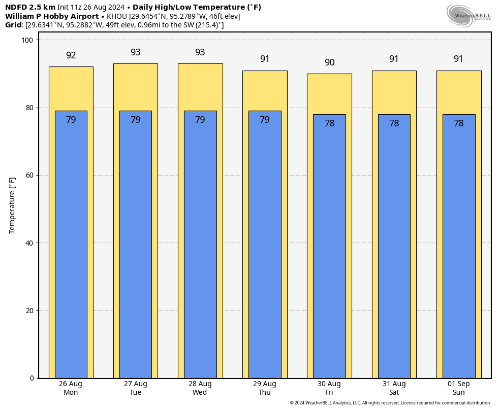
As we near the end of the month, this pattern is about to change. High pressure anchored over West Texas this summer has backed off, opening the door to moisture from the Gulf of Mexico. Accordingly, a pattern of showers and thunderstorms should persist through this week, and into the weekend. We can expect daily rain chances to go along with high temperatures generally in the low 90s. Overall I don’t have any real flooding concerns, but with the return of high school football and other sporting activities, you’ll definitely need to watch for the potential of showers and thunderstorms on a daily basis.
Monday
A low pressure system in the Gulf of Mexico will help to drive high rain chances today. These showers are presently lurking just offshore, and they should move inland later this morning and throughout the day. Rain chances today, and for much of the rest of this week, will be higher along and near the coast, closer to the source of moisture. But even areas well inland, such as The Woodlands and Katy, will have a decent chance of rainfall each day. Skies will be partly to mostly cloudy today, with highs of around 90 degrees or just above. Winds will be from the east at about 10 mph, with higher gusts. Low temperatures tonight will drop into the upper 70s.
Tuesday
Expect a similar pattern on Tuesday, with the potential for showers and thunderstorms. Not everyone will see rainfall, but a majority of the Houston area is likely to.
Wednesday, Thursday, and Friday
The general pattern of showers and thunderstorms developing offshore, and then moving into the Houston area during the morning and afternoon hours, should continue. Overall, our evenings should be free of rainfall this week, but I would not make any ironclad guarantees. Highs will continue in the vicinity of 90 degrees into the low 90s, a nice contrast to the heat from the rest of this month.
Saturday and Sunday
More of the same, probably. I think we’ll see highs in the low 90s this weekend, with a mixture of sunny and cloudy skies. Daily rain chances will, again, probably be 50 percent or higher, with better chances near the coast. Nights remain warm, with lows briefly dropping into the upper 70s.
Next week
There is some evidence in the global models of another surge in rainfall on Monday and Tuesday of next week, but that is far enough into the future that I’m not overly confident. In any case, the most likely outcome for weather next week is that this wet and somewhat cooler pattern continues for at least a few more days. There’s some evidence of a push back toward highs in the mid-90s during the second half of next week, but I could just as easily see us staying a bit cooler. We’ll see!

🥰 thank you for the update.
I’ll take Aug heat over January freezes ANY DAY & twice on Sundays. It’s one reason I moved from Dallas to and stayed in H-Town 🥳🎊🤣
Leaning on that, models are overdoing it with rain totals. And the same ol same ol coastal areas getting most of the rain when that never really plays out. This is an ULL not a tropical system, it’s hit and miss type rain.
It’s been annoying to see my phone consistently saying we have a chance of thunderstorms with basically 0% predicted every day (Woodlands).
Looking at Wunderground radar, there’s a circular rain pattern coming up thru Freeport and Bryan Beach, and moving up and between Lake Jackson and Bay City, then dissipating. I doubt we’ll see any rain up here in Magnolia.
And yea, watching Fox26 weather a few minutes ago, Mike explained about the upper-level-low.
Boy, was I rwong!!
Ironically enough, just as our in-ground sprinkler system turned off, ten minutes later, we’re getting a downpour up here in Magnolia 👍
Also, a wonderful side effect … it’s 73 degrees!!
lol, love that
Vaya con Dios 100’s in 2024. Next stepping stone will be saying adios to the 90’s and Fall Day 2024!
Here is my prediction based off of recent history. The heat ridge that is shifting to the north is going to drift down back over Texas sometime during the 2nd week of September. Then we are probably going to see a week or more of temperatures back in the upper 90s if not triple digits again. After that we might see a weak front in late September that will bring us a night or 2 in the 60s. Hopefully I’m wrong and we will actually have a normal September for once but normal doesn’t really exist anymore.
If a heat ridge sets up again, then maybe it’ll fend off tropical systems. That could be a good thing.
We’ve been trying for weeks to get painters to paint our house, and they were finally starting this week.
So, you’re welcome.
Thank you for your sacrifice.
Normally the humidity hits me in the face like a slap when I exit my house to leave for work in the mornings (especially Sundays at 5am) but this past Sunday I was like “huh.” I will also take August heat over TS’s or anything dangerous though!
“Overall I don’t have any real flooding concerns, but with the return of high school football and other sporting activities, you’ll definitely need to watch for the potential of showers and thunderstorms on a daily basis.”
I never realized there was a correlation between sports & weather, if not a causative effect. Learn something every day.
Yesterday was hot, but it was a good hot. Looks like we have turned the corner with Labor Day the last of what I call the Big Three Summer Holidays (Memorial Day, 4th of July and Labor Day). So, 30 more days of Summer (give or take a few days)! We’re almost there y’all, hang in there! Worst of the worst is over!
I must say. I’m looking forward to when these posts include model forecasts of cold fronts.
73 degrees and raining in Magnolia at 12noon 🙂
I have noticed a general sign in the Canadian and Euro models for a cold front after this rainier period. Any thoughts?
A signal seems to be there, and some of the models are picking up on it.
I just checked the NHS “7-Day Graphical Tropical Weather Outlook”. There’s a possibility cone (my wording) they’ve drawn for Central Tropical Atlantic.
…
* Formation chance through 48 hours…low…near 0 percent.
* Formation chance through 7 days…low…20 percent.