Just a quick update on Wednesday afternoon to say that our forecast from this morning holds—effects from Tropical Storm Cindy are unlikely to be too significant for the greater Houston area. Mostly, we can expect some heavy rainfall. The only thing that could change this is if the storm follows a westerly track into the Galveston area, but at present that seems to be a low probability.
Rainfall
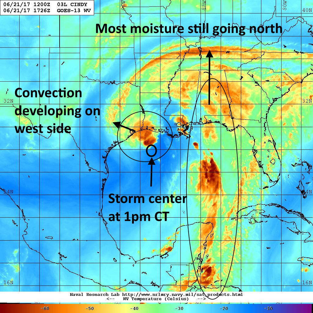
We’re starting to see some convection firing up on the west and northwest side of Cindy’s center today, but the storm is running out of time to become a real rainmaker for the Houston region as it will near the coast tonight, and move inland by Thursday morning. The water vapor image below shows some of the convection developing out in front of Cindy as the storm moves northwest toward the Texas-Louisiana border.

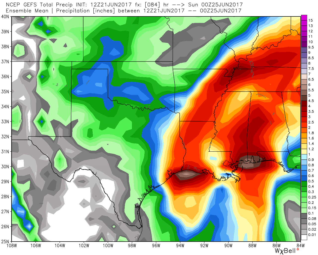
Most of the model guidance suggests the Houston region will likely see 1 to 3 inches of rain from Cindy later today, tonight, and on Thursday. Generally, rain chances will be greater to the east of Interstate 45. Given the tropical nature of this system, we can’t rule out some isolated bullseyes of 6 inches, but I think we can confidently say this is likely not going to be a major flooding event for the area.

Tides and winds
At present waves are coming up onto Bolivar Peninsula, and seas are rough, but road conditions along the coast are generally manageable. Rip currents are a concern as well. It looks like high tides will reach a maximum of about 4 feet above normal.
In regard to winds, expect some gusts tonight in the upper 20s or low 30s in the city, and possibly in the low 40s along the coast. Sustained winds will be lower.
We’ll keep you posted as conditions change.
Posted by Eric at 1:55pm CT on Wednesday
Great, always appreciated these updates!
Thanks for the update!
Do you mean WEDNESDAY? Or is Tuesday the latest info you have?
Yes I did.
Thanks Eric for your vigilance and the updates..spending the day in the yard enjoying the NE or so breeze…it’s wonderful!
Hey Eric,
Great site, love the style and information.
Just wanted to let you know that my mobile browser (Chrome) redirects spacecityweather.com to a page saying you moved servers and with instructions on how to clear the browser’s DNS to be able to access it again.
I did it, no problem, but probably a lot of your readers will not be able to. I’m not sure if it’s a widespread issue or not, just letting you know in case there’s something you can do on your side to fix that.
Congrats again, let’s hope this forecast does not need any changes!
Thank you for the nice comment. Yes, we’re working through some DNS issues after moving to a better server last night.
I’m currently at Perdido Bay. Will the rain clear out by Friday?
Chance of showers lingers into the weekend, but I’d expect at least partly sunny skies by Friday afternoon.
What about the weak Saturday cold front, Eric? Will that cause us any severe weather problems?
No it will not.
For folks in Shreveport, the threat for additional heavy rainfall will enter on the heels of Cindy, as her departure coincides with a deepening backdoor cold front Friday/Saturday/Sunday. There’s a very moist airmass in place, and it’ll supply this disturbance with abundant moisture for efficient rainfall-producing tstms Friday through the weekend.
However, I do have some concerns about lift from the Gulf of Mexico when the frontal boundary sags into SE Texas. What are your thoughts, Mr. B?
I certainly think we’ll see some showers and thunderstorms this weekend, but at this point I’m not overly concerned about any kind of flooding.
I see you don’t monetize your page, don’t waste your traffic, you can earn extra cash
every month because you’ve got high quality content.
If you want to know how to make extra $$$, search for: best adsense alternative Wrastain’s tools