In brief: This post provides an update on our expectations for the winter storm next week, which is now increasingly likely to bring a hard freeze and snow to Houston. The period from Monday night through Wednesday morning could be challenging from a roads and airports standpoint.
Why we are posting on Friday afternoon
As we continue to see more model data, our confidence is increasing in a severe cold snap next week, along with the potential for measurable snowfall that could prove disruptive for travel plans on Tuesday and Wednesday of next week. Although the details remain impossible to forecast, it is now more likely than not that we will experience a serious winter storm in the Houston region four days from now.
How long do I have to prepare?
Conditions today are fairly comfortable outside, and tonight will be mild. Some very light showers will be possible overnight, ahead of the passage of a cold front on Saturday morning. However, as the colder air will be lagging behind somewhat, Saturday should be fine temperature-wise, in the upper-50s or so. By around sunset, however, temperatures will start to drop. A light freeze will be possible across much of the Houston metro area by as early as Sunday morning.
Sunday should be sunny, windy, and chilly. Temperatures on Monday morning will fall below freezing for pretty much the entire metro area, with a hard freeze (temperatures of 25 degrees, or below) possible along and north of Interstate 10. So any freeze preparations on pipes and plants should be completed no later than Sunday.
However, we likely will remain largely free of precipitation on MLK Day. So while it will be cold on Monday, with high temperatures only in the lower 40s, mobility should not be an issue. However, by Monday evening, we could start to see snowfall, and temperatures will drop below freezing pretty quickly. Travel after Monday evening may become hazardous.
Winter storm
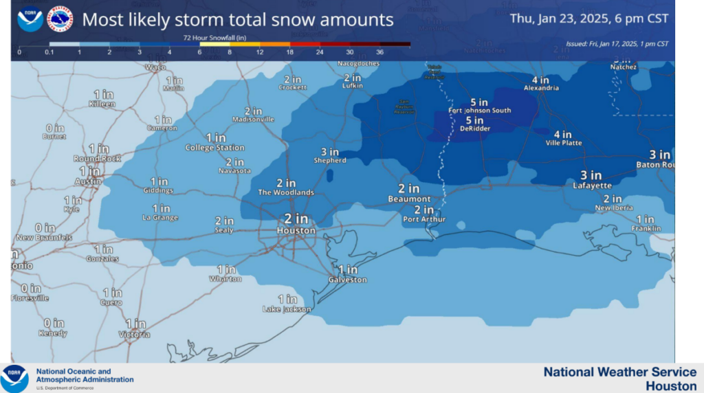
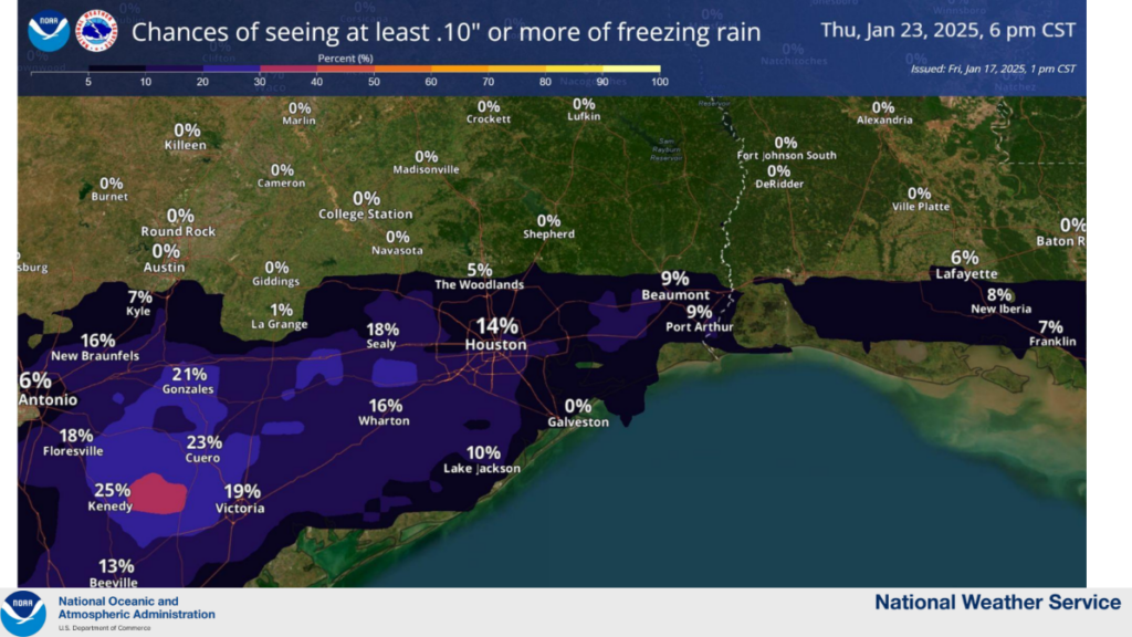
At this time it looks like most of the precipitation that falls early next week will probably be snow. For some areas south of Houston, particularly in Brazoria and Matagorda counties, there may be more sleet or freezing rain. It’s not clear where that transition will occur, but it is entirely possible that Houston wakes up on Tuesday morning and there are 3 or 6 inches of snow on the ground. This would be the most snow Houston has received in at least two decades.
The bottom line is that we’re increasingly confident that temperatures will be well below freezing on Tuesday morning, and that there is likely to be precipitation. That means that whatever falls, is going to stick. And since temperatures may only briefly reach above freezing on Tuesday—and for some areas in Montgomery County and points north, temperatures may not rise above freezing on Tuesday—whatever falls may stick throughout the day and again for Tuesday night into Wednesday morning.
For that reason, we believe there is the potential for significant disruptions to mobility around Houston on Tuesday, and probably into Wednesday morning. Speaking of Wednesday morning, it actually looks to be the coldest of the period, with temperatures in the low 20s in Houston, and perhaps even lower depending on the extent of snow cover.
So if you’re making plans for next week, consider that much of the city could be shut down for Tuesday and part of Wednesday. Fortunately we should see sunshine on Wednesday, with temperatures warming into the 40s during the afternoon. This should help improve road conditions.
Preparations
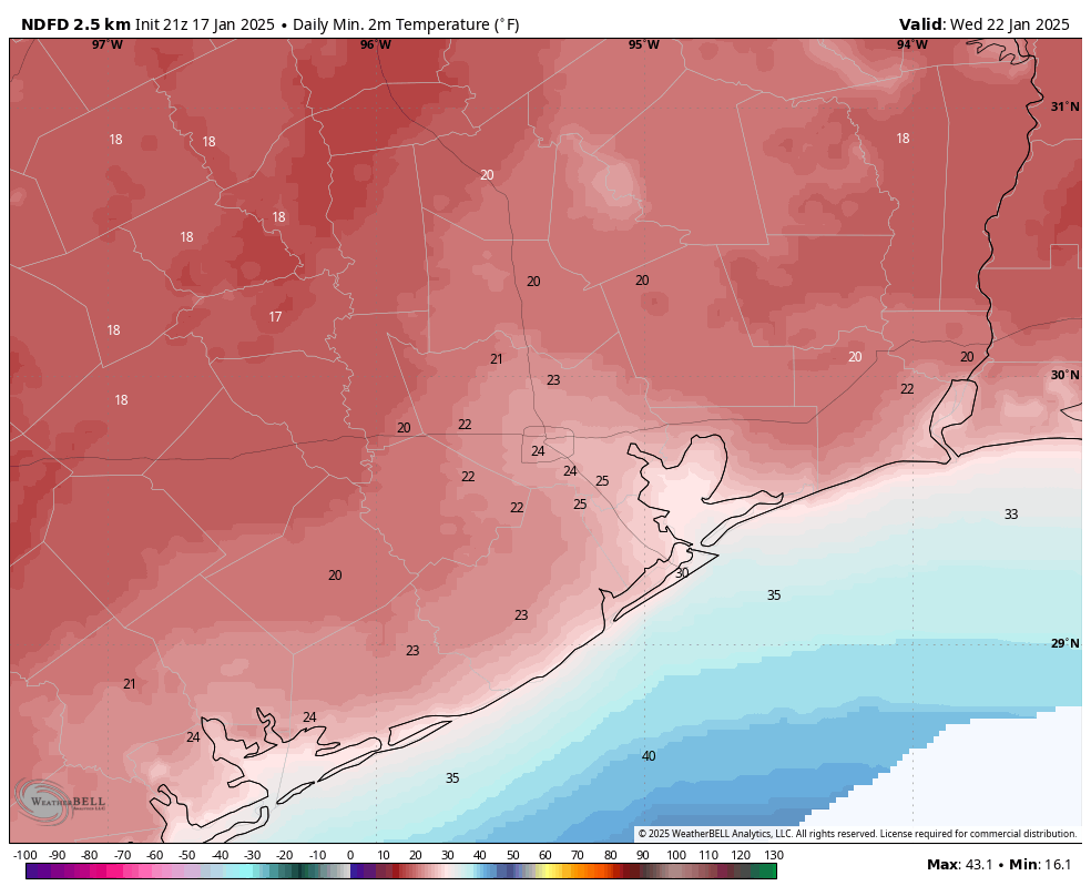
Temperatures in parts of Houston will drop below 25 degrees as soon as Monday morning, and much of the region (with the possible exception of the coast) could see a hard freeze on either or both of Tuesday and Wednesday mornings. This is cold enough to threaten exposed pipes, sprinkler systems, and more. Here are some basic preparations to undertake:
- PLANTS. Protect tropical vegetation. Please note, with temperatures dropping this low, some vegetation will probably die regardless.
- PIPES. Protect any exposed outdoor pipes. Pipes in attics and along exterior walls of structures could freeze at these levels.
- SPRINKLERS. Sprinkler systems should be shut off and properly drained.
- ANIMALS. Prepare proper shelter and warmth for animals and livestock and make sure water sources are not frozen.
Electricity
It is beyond the scope of this website to make predictions about the availability of electricity during this winter storm. However, there are two basic issues to consider. The first is power generation at plants. This is what caused widespread power issues during the winter storm during Valentines Day in 2021. We don’t think temperatures will be quite that cold this time, and the state of Texas made significant investments after that cold outbreak. So theoretically there should be electricity available to the grid managed by ERCOT. But we’ll see.
The other step is distribution, which is the lines and poles component. If we get snow that is better than freezing rain, which can stick to power lines, weigh them down, and cause them to snap. So that will be another factor to monitor.
At this time we don’t anticipate major power disruptions during the winter storm, but certainly that is not something we can guarantee.
Our next update will come on Saturday morning.

Has anyone checked on energy providers to ensure they’re aware of the forthcoming weather? Because it seems like last time they were somehow COMPLETELY caught off guard… probably on purpose to ensure their huge windfall from the state.
After Snowpocalyupse I learned my lesson. I have a panel interlock where I can hook my generators directly into the panel and substantial fuel stores to maintain power and a Indoors propane heater just in case the NG fails. My motto is “never again”.
You can use a propane heater inside?
Yes. The Mr Buddy range of heaters are excellent and safe.
They know it’s coming. Probably turning power generation offline now to help the bottom line.
The trends seem to be getting worse and worse…… maybe we should just stop forecasting?
Why?
You mean better and better.
That’s cool ❄
This is likely to be our fourth trip down into the teens in the last five years. Counterintuitive to expect this in a warming world. I kind of miss the balmy temps we had back in December when the usual suspects were complaining about the heat and humidity becoming our constant winter companion.
I’m old enough to remember the last gap between ‘snow days’ was 2004 to 2017. Then it was 2017 to 2021. And now it’s 2021 to 2025. At some point soon, I expect ice freezes to become a yearly event.
There was snow in 2008 and 2009 as well
A warmer planet causes extreme weather conditions as it disturbs jet streams, pressure systems, etc. That’s why we’ve seen such a high increase in the frequency and intensity of hurricanes
I believe you, but I love data. What data do you have to refute your position that first, a warmer planet causes extreme weather conditions. Secondly, the silly notion that there is an increase in the frequency and intensity of hurricanes. Not baiting you into a conversation, just curious.
She doesn’t have one…..she simply FEELS this phenomenon. Left out of EVERY conversation that mentions the false “Global Warming” nonsense, is looking at the WATER Vapor concentration in the upper atmosphere. When the percent of water concentration in the Upper most part of the Atmosphere INCREASES, so does the PERCEPTION of global warming. Now, I admit that this water vapor in the upper most reaches of the atmosphere DOES have a small influence on global weather patterns, to claim it is predominately from human influence is incorrect. Water Vapor concentration has increased and ebbed since the beginning of time, and will continue to do so. Taking a 20-40 year snapshot of “weather” and inferring that the snapshot represents a definitive pattern is nonsense.
Why would she refute her own position?
Law of Rhythm (5th Hermetic)
It’s actually not counterintuitive to see cold snaps in a warming world
climate scientists have been saying for a long time that a global warming could destabilize the polar jet stream, causing more frequent cold snaps in lower latitudes.
And one cold January over parts of the U.S. does not contradict the global warming trend. Last December was so warm in our region that this colder January may not balance out how warm December was. And if February is much warmer, then this winter will still end up averaging above normal.
The main point is that while we still can still expect cold spells here and there, average temperatures will continue to rise in the coming years and decades.
Would it be possible for you guys to address Galveston? It appears that it will escape the hard freeze?
On the last map, it shows a low of 30 degrees in Galveston on the coldest morning
Thanks – the clarity on what’s known and not known is super helpful.
Off to buy all the bread and milk! 🥛 🍞
Weather for Kansas City on Saturday afternoon.. High 23F. Winds N at 10 to 20 mph.
What should us marathoners expect?
Hypothermia
😅
Fingers crossed this will not be a repeat of Valentine’s Day 2021 !!
I’d see the snow part being slightly more than 2021, but shorter duration, and the cold not being anywhere NEAR 2021
Ty for the updates. I don’t understand the cold stuff very well. Super appreciate you 💗
What does this mean for the airports on Tuesday and Wednesday?
As of now, are both the temperature and precipitation forecasts worse than this morning’s post? Or is it just the precipitation that is worse (more likely)?
From what I understand, we are probable to get snow storms over ice storms..Less dangerous for power lines..
Oh well, this means we will have to start all over again when it warms up with replanting the tropical plants and buy new plants for the pots. It’s a shame, but there it is.
Grr, I have a young bottlebrush that did a good job recovering from last year’s freeze damage…I hope that because it’s more established, that it will suffer less damage than last year..The poor confused bush put out a couple of blooms in the past two / three weeks..
Oh, give that it’s basically Saturday already and this is supposed to have on Monday -Tuesday , if appears weather forecasting is only “confident” two days before the event. Arggg.
The comment about some tropical plants dying regardless is not entirely accurate.—so for plant lovers, don’t lose hope! We’ve dipped into the teens for a prolonged time before, heavily mulching tropicals and covering them will likely enable them to come back from the root system . Keep the hope for your babies!
💗 🌱 💗
This is going to be absolute disaster. Tow truck drivers rubbing their hands together like Birdman.
My hope is the drainage ditch behind my neighborhood stays shallow enough that it freezes so I can ride my trashcan lid down the embankment. That probably sounds bleak to non-houstonians but I am absolutely jazzed about the possibility.
Take a pic!🙂
I am also not understanding why on Tuesday Dallas’ high is at 38 (not freezing) while Houston’s forecast is colder at a high 32 (freezing)— so much for the gulf water influence , hmmm again
Snowmageddon!!
Copied from Accuweather:
“Houston is no stranger to winter storms. Over the past 130 years, 1-4 inches of snow have accumulated during many storms, including a whopping 19 inches from a single storm in mid-February 1895. That blockbuster storm dropped 1-3 feet of snow in a massive swath and affected many areas farther to the east in the South Central states, including in New Orleans, where about 8 inches of snow piled up. Lafayette, Louisiana, received 14 inches of snow from the same storm.”