As Eric noted this morning, it looked possible that areas well north of Houston could see some ice pellets (sleet) mix in with the rain tonight. That continues to look like a possibility, and the forecast looks intriguing beyond tonight too. Let’s talk wintry weather chances.
Tonight
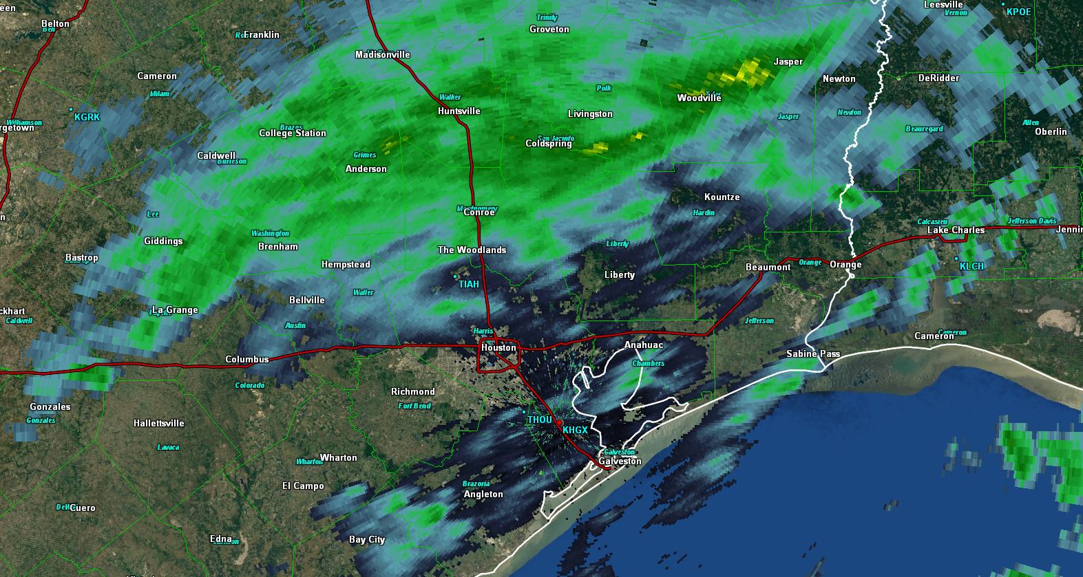
Radar as of 5:30 PM Wednesday shows a good bit of shower activity in the region, especially north of Houston. Rain has been pretty light and mostly just added to the dreary ambiance of the atmosphere today.
As we go into tonight, expect a few more rounds of rain, perhaps steady at times. Temperatures tonight should hold steady or continue a slow drop over most of the area, and I’d expect overnight lows to bottom out in the 38-42° range on average. That’s safely above freezing, so in and around Houston, I’d honestly be surprised to see anything other than plain rain tonight. North of Houston (say up toward Conroe, Hempstead, or Brenham), I wouldn’t be shocked if you hear some “pings” of ice pellets mixed in with the rain late tonight.
Thursday
I think Thursday is pretty straightforward here. We should see continued light rain much of the day. Temperatures aren’t going to warm up much. Upper-40s should be about as good as we do in some spots. Mid-40s will suffice in others. But mild-ish temperatures should prevent any wintry precipitation from mixing in.
(Space City Weather is brought to you this month by the Law Office of Murray Newman)
Thursday night
No winter weather event is easy to forecast, especially in the South. Tomorrow night becomes very challenging. I’ll do my best to explain why here. First, if you look at an animation of forecast dewpoints off the NAM model from midday tomorrow to about midnight tomorrow night, you’ll see dry air punching in from the north. Dewpoints are a general measurement of atmospheric moisture, so the lower they go, the less moisture there is to work with.
You can see how dewpoints crash through the 30s and into the 20s on the last few frames. So the first question we have to ask is, “Will there be enough moisture for precipitation tomorrow night?” Well, it will be close. My guess is that north of I-10, things tomorrow night will end without much fanfare: Maybe some sleet or a few wet snowflakes mixed in with the rain, but this air looks so very dry that I just don’t think moisture can make the trip to the ground by the time it gets cold enough for wintry precip.
So what about south of Houston? Here’s where things get interesting. We have drier air trying to punch in, but it’s not quite there yet. So I suspect you have moisture falling and reaching the ground, particularly south of US-59. The next question becomes: Is it cold enough for snow?
Let’s get into the meteorological weeds here. Below is a chart of a NAM model forecast. It’s from Brazoria County Airport near Angleton & Lake Jackson. The forecast is valid for 1 AM on Friday. I’d suggest you right click the image and open it in a new tab to see the features better.
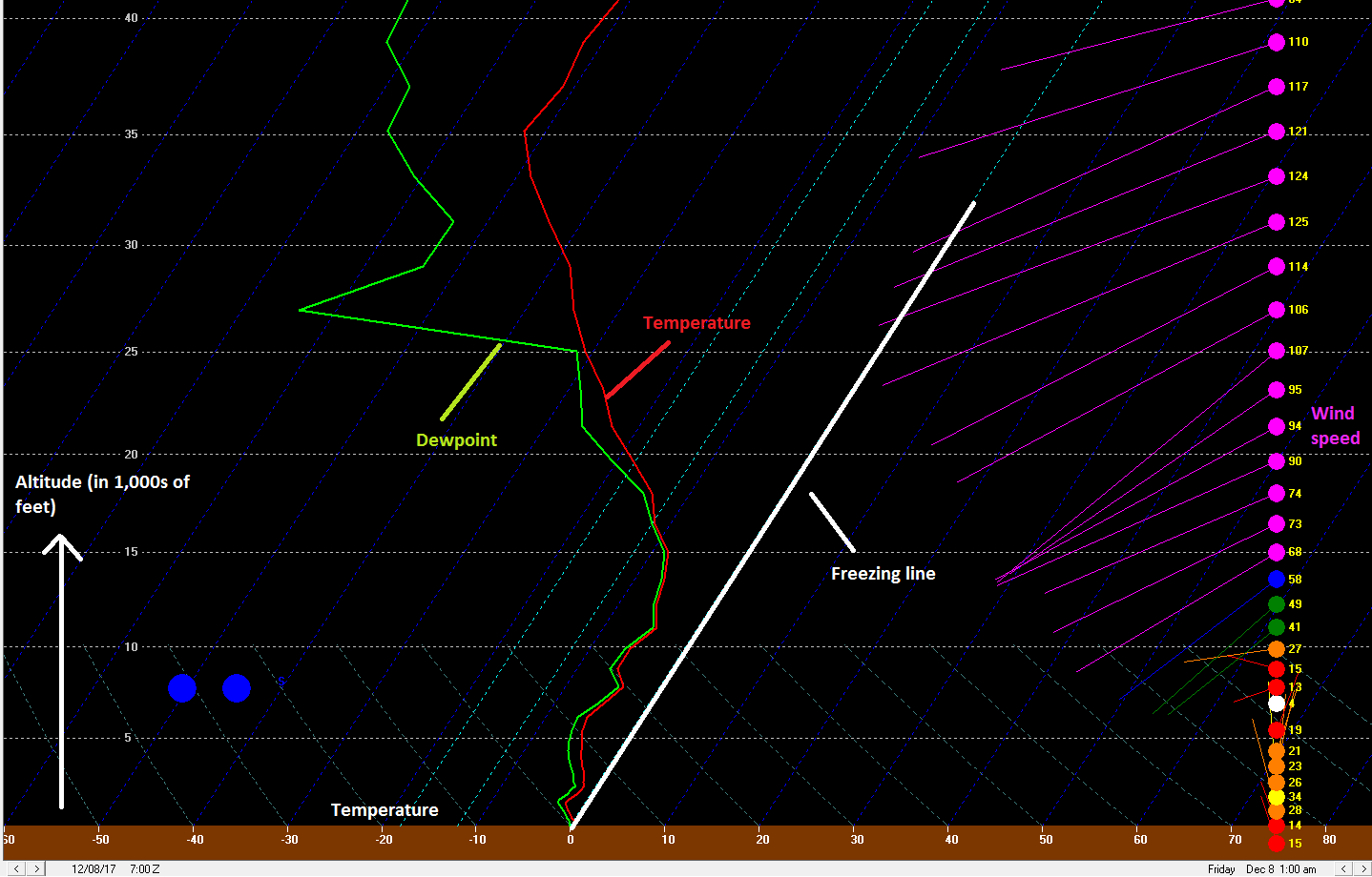
This chart is a forecast Skew-T diagram. You can go into the weeds further and learn more from this video if you’re so inclined.
Anyway, this shows a vertical profile of atmospheric temperature, dewpoint, and wind. The red line represents temperature, the green line dewpoint, and the “barbs” on the right-hand side are wind. The axis at bottom shows temperature, while the axis at left shows vertical height up in the atmosphere up to 40,000 feet or so. What I want you to notice here is the red line and how it compares to the thick white line I highlighted, which is the 0°C, or 32°F freezing line. You can see that the red temperature line is well off the freezing line until you get to the very bottom of the chart, which would be ground level. So temperatures tomorrow night will likely be above freezing at the surface, but you only have to go a few hundred feet up to get below freezing. Because of this, any precipitation that falls south of Houston tomorrow night may not have enough time to melt before it gets to the ground. This means you would see it fall as sleet or snow (in this case, probably snow).
So we’re probably going to have the ingredients in place for precipitation to fall as snow tomorrow night, BUT it will all hinge on how quickly the atmosphere dries out. Right now, we think that it will dry out quickly enough in most of the Houston metro area to avoid snow, other than perhaps a few flurries at the tail end of the rain. As you go south of Houston, say into Brazoria or Matagorda Counties or down closer to Corpus Christi, there may be the right combination of cold air and moisture to allow for snow to fall. Some models do hint at the possibility that enough precip will fall as snow down there to accumulate a little bit. I wouldn’t be surprised if we see a couple snowy scenes from the Coastal Bend on Friday morning.
That being said, I opened this section by saying that no winter weather event is easy in the South. Well, with that in mind, we’ll need to watch things closely over the next 12-24 hours to see if anything changes. Consider this our best thinking for now. Eric will have the latest in the morning.
Let it snow! Let it snow! Let it snow!
Do you see any chance of power failures due to ice and snow, Matt?
WHOAAAAA…wait a minute…I’m done with winter!!
Uh, Matt—-think Worrybug’s just asked a good question. We certainly don’t want a Harveylike power crisis due to icing on trees and power lines. Might want to answer him.
I remember hearing that when we have a hurricane, that winter we have snow. Any validity to that happening?
As long as I can remember every time we have had a large tropical system the winter seems colder. We’ve had ice/snow with some of them.
It’s most certainly not a “rule.” But this year probably won’t do anything to change anyone’s mind on it! I do think it’s coincidence more than anything.
“Dreary ambiance” is enough for me.
I absolutely love the weather geekery. Keep it coming – the geekier the better!!!