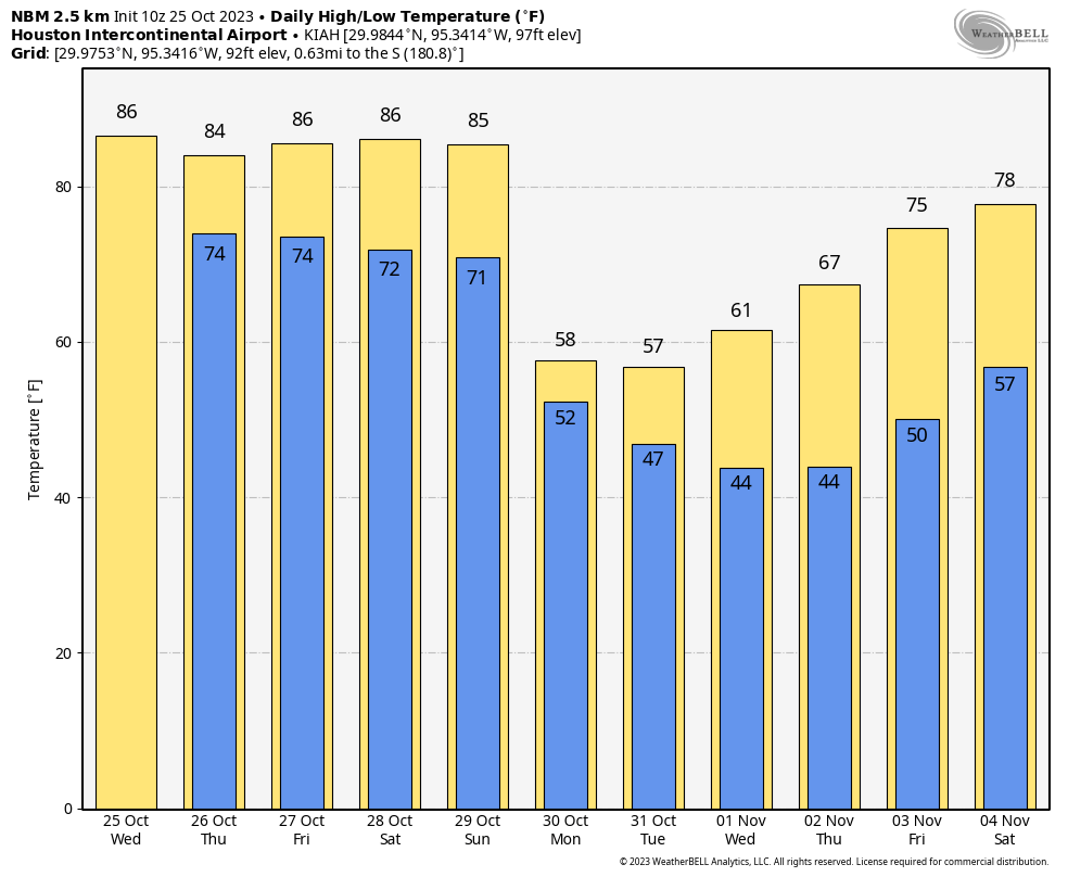
Good morning. Houston will remain in a warm pattern through most of the weekend before a robust cold front arrives on Sunday evening or early Monday to cool us down significantly. There will also be some rain chances throughout the period—before, during, and after the front. My sense is that most of this rain should be gone by the time of Halloween, but the current forecast looks pretty cold for trick-or-treating, with temperatures likely in the 50s.
Wednesday
Another warm day is on tap for the Houston region today, with highs in the mid-80s and southeasterly winds at 10 to 15 mph with higher gusts. Skies will be partly to mostly sunny with the warm flow. Some rain showers will be possible today, but they should be fairly scattered, and most likely closer to the coast and south of Interstate 10. Slight rain chances will continue overnight, with lows only dropping into the mid-70s.
Thursday
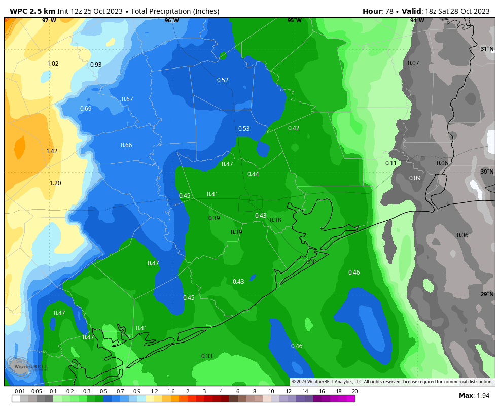
This day will see a mix of clouds and sunshine, with highs in the mid-80s. By late morning or early afternoon, a broken line of showers and thunderstorms should start to sag through areas such as College Station, and then down into the Houston area. The upper-level disturbance driving these storms is not super potent, and my sense is that most areas will see 0.25 to 0.75 inch of rain, with the potential for a few areas to see 1 inch or more. The best chance for higher accumulations will be the western half of the metro area.
Friday
Expect partly sunny skies with highs in the mid-80s. A chance of rain will linger, perhaps 30 percent.
Saturday and Sunday
The first half of the weekend will be warm and humid, with highs in the mid-80s and mostly sunny skies. Rain chances on Saturday are low, but not non-existent. Sunday is a bit more interesting as it looks like the front may come to the region a little bit faster. For now, I think most of the area will still see a fairly warm and humid day, with highs in the mid-80s. Rain chances will depend on the timing of the front, as I think there is a pretty good likelihood that showers accompany the frontal passage.
Next week
Who is ready for some cold weather?
By Monday morning we should see much drier and chillier Canadian air flowing into the Houston region. Highs will depend on cloud cover, but Monday through Wednesday of next week may top out in the upper 50s, with overnight lows in the 40s. This is positively winter-like for Houston, especially with blustery northerly winds on Monday.
As for Halloween, right now I think we’ll see clearing conditions, but temperatures during the trick-or-treating hour are likely to be in the mid-50s, probably. So be prepared. Temperatures should gradually warm during the second half of next week.


Wow, normally my furnace doesn’t turn on till sometime mid to late November.
Oh lord, not the cold weather arriving already?!
I like to see your reaction if it starts to snow… lol
The winds have been punishing and terrible, bringing down a large branch in my yard. Those chilly type days when the temperature drops 30 degrees in a day are the worst, which is why summer is great. You never have to worry about what to wear, or have extra clothes that you either don’t need until later or that you needed earlier but now it is too warm for them.
Can you bring the cold air in any sooner? Upper 80s and humid in late October is ridiculous. Especially when you have to be outside in flame-retardant coveralls and a hard hat during the afternoon.
I’m with you Blackhawk! I hate the roller coaster weather we get. It’s so hard on my body at 62. Can’t we get some sustained cool weather after the Hellish Summer? NWS says it will go back up to 75 later next week.
No:
Love this! ! Can finally enjoy being outside after such a hellacious summer!