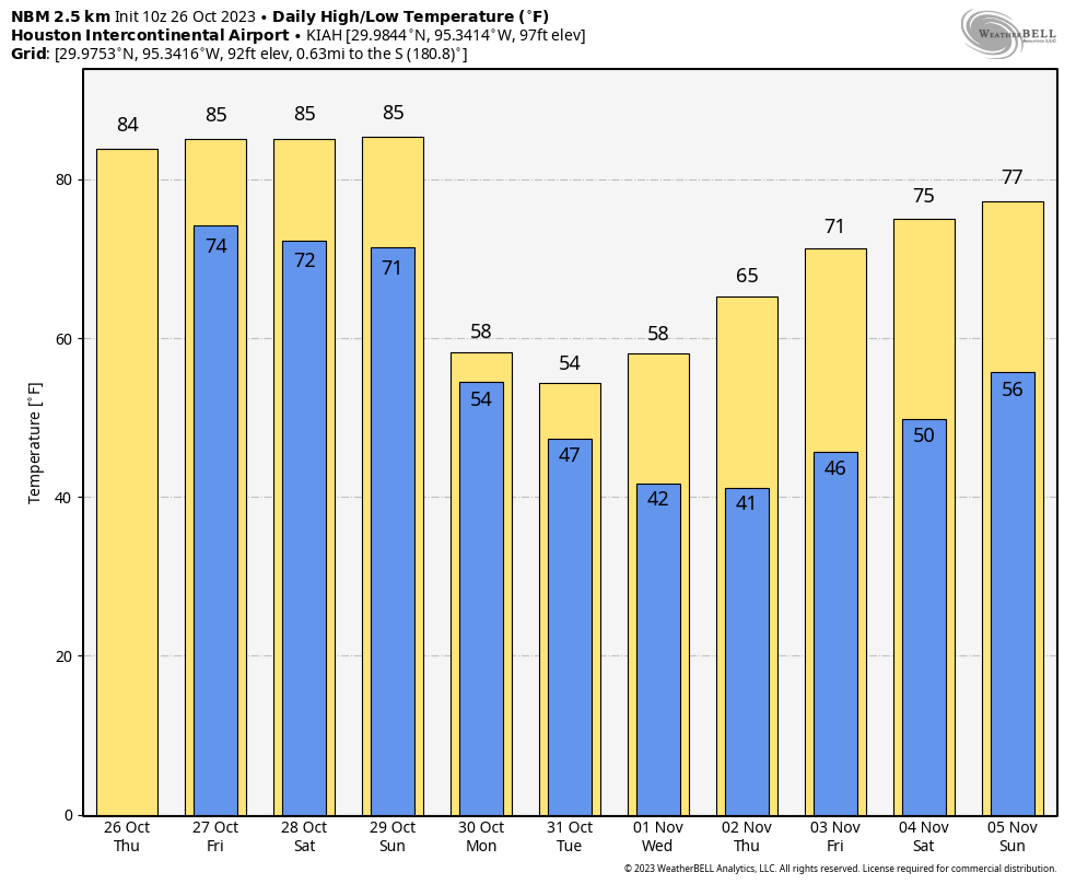
Good morning. Houston faces four more warm days before take out first deep dive into much cooler weather. How cold? Well, most of the Houston region will likely dip into the low- to mid-40s at some point next week, and a few outlying areas might actually see the upper 30s. So yes, it’s going to be sweater weather. Halloween, as well, looks breezy and cool with temperatures of perhaps 50 degrees by the time kids start knocking on doors.
Thursday
The story for today is rainfall, or at least its potential. An upper-level disturbance will produce a mass of showers and thunderstorms to the northwest of Houston that will slowly sag down toward the area today. These storms should reach the College Station area by around noon, and push into the central Houston area later this afternoon and evening. It’s worth noting that, as they push into Houston, the showers will be losing their oomph. So if you live inland of Highway 59/Interstate 69, you have a pretty good chance of picking up 0.5 to 1.5 inch of rain between now and Friday morning, with higher isolated totals beneath heavier showers. Areas further to the southeast, particularly closer to the coast, should see substantially less rain.
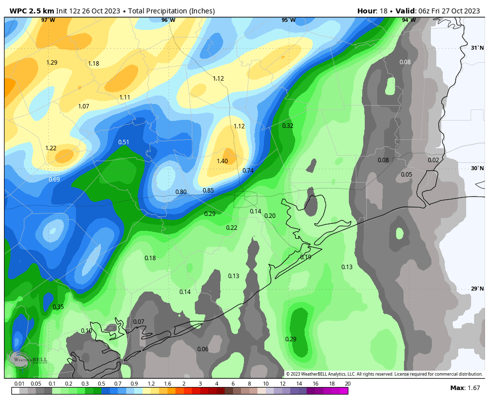
Otherwise, expect partly sunny skies today, with highs in the mid-80s. Winds will be out of the south at about 10 mph, and gusts up to 20 mph. Rain chances should end late this evening, and almost certainly before midnight. Lows tonight will drop only into the mid-70s.
Friday
This will be another warm, humid day with highs in the mid-80s. We’ll again see a mix of sunshine and clouds. Rain chances will not be as high as Thursday, but we’re still going to see at least a smattering of showers, if not more. I’d peg rain chances at about 40 percent, with lesser accumulations than Thursday.
Saturday and Sunday
The weekend should see continued warm and humid weather, with two days of partly to mostly sunny skies and highs in the mid-80s. Both days will have a low chance of rain, perhaps 20 percent. All eyes, meteorologically at least, will be on the forthcoming front. But at this point it probably won’t reach the Houston metro area until late Sunday evening, perhaps crossing through downtown around midnight, give or take a few hours. We’ll likely see some showers will the front, and drier and cooler air almost immediately after its passage.
Next week
High temperatures on Monday are likely to be in the 50s, area-wide, so bundle those kids up as they head off to school. Add on to this mostly cloudy skies and blustery northerly winds, with the possibility of some scattered showers, and it’s going to feel downright chilly. Lows Monday night will drop into the upper-40s, probably.
So what about Halloween? I think it will be another partly to mostly cloudy day with highs in the 50s—perhaps even in the low 50s. There may be a few lingering showers, but I think skies will dry up before it is time to trick-or-treat. It’s possible that a reinforcing front drives low temperatures into the lower 40s by Wednesday or Thursday morning, but the forecast is starting to get fuzzy by then. We should start to warm up heading into next weekend.


Can’t wait for the cool air to get here. Mid to upper 80s in late October should be illegal.
I recall on unusually hot days like these my abuelitos (grandparents) in the south Texas area would always say that this heat is bringing in some cold. They were always right!
This is abysmal. I am ready for 50s!
Patience, stranger
About 12 hours too late for the Houston Half on Sunday morning. Lube up runners – it’s going to be a sweaty slog out there.
Eww
cooler air! cooler air! cooler air! 👻
🌬 🍂🍂 🎃 🍂🍂
(& candy!)
Good splash of rain just after midnight and soaking rain now just south of the Loop. We’ll take it.
Disgusting cold weather coming in already. Hopefully it warms back up at bit.
Bust on the rain in SW Houston, only .25″ so far and not looking too promising either. Does the coming cold front qualify as a “blue norther”? I haven’t heard that term in a while.
Blue northers usually drop temperatures between 20 and 30 degrees within an hour of arrival accompanied by strong gusty winds. I’m not sure if this cold front is going to drop temperatures that fast here or not. But it is possible.
Well, I’m glad I have somewhere to bitch and complain. Again, we weren’t able to get one drop of rain today. Dickinson always gets the rain, but not us here in Santa Fe! And after today forget it! Now we don’t expect to see any rain for the foreseeable future and I’m already back to watering nonstop just like I’ve been doing for the last 4 months!!!!!