Historically, this week marks the statistical peak of the Atlantic hurricane season. This year looks to live up to the hype as well.
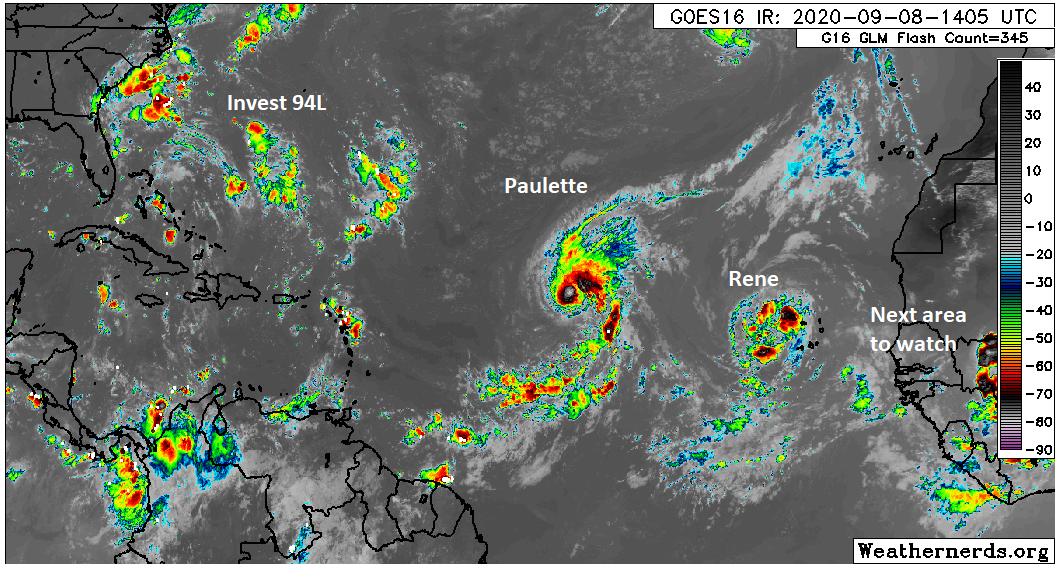
We have two tropical storms in the Atlantic today and there are likely to be at least a couple more before next week. We don’t think that any of these systems will seriously threaten the Gulf, however it is important to keep monitoring things, particularly with respect to the third system in line.
Tropical outlook in a sentence
Tropical Storms Paulette and Rene will likely be followed by a third system this week off Africa, and while none looks especially likely to make it to the Gulf, it would be wise not to write them off completely, particularly the third system, given the recent model difficulties we’ve seen.
Tropical Storm Rene
I want to get Rene out of the way first because I think this one has the least future of note, as it relates to the U.S.
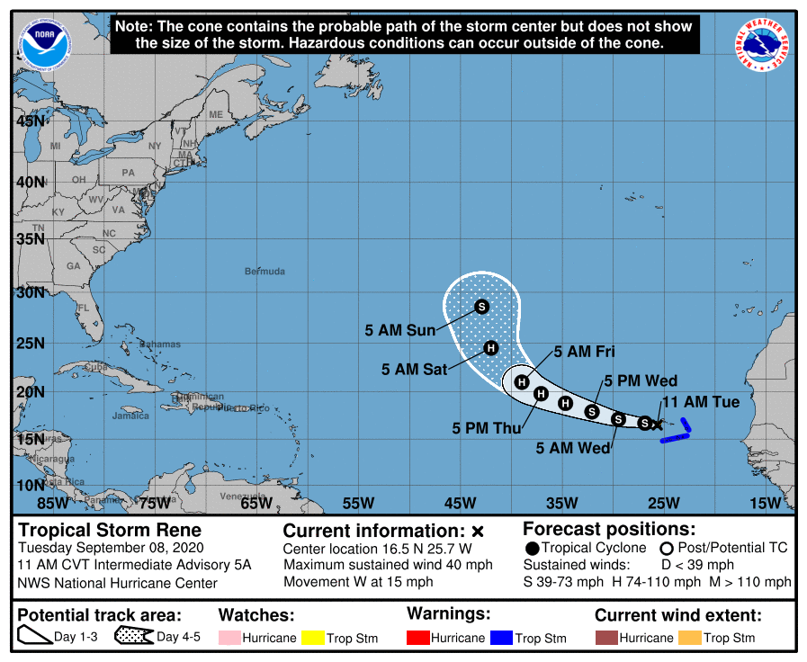
Tropical Storm Rene has 40 mph maximum sustained winds, and it is impacting the Cabo Verde Islands today. It is expected to track west and then turn northwest and north as it finds a “weakness” in the upper air pattern. The pattern does get a bit convoluted late, so Rene seems to strike me as a storm that could hang around in the open Atlantic for awhile, possibly taking a weird track as it does so. But it will not be a threat to the U.S. or Caribbean.
Tropical Storm Paulette
Tropical Storm Paulette has winds of 50 mph, so it’s a bit stronger than Rene. It’s also farther west. Paulette’s future is a little more difficult to project.
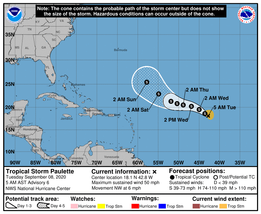
Paulette is going to be steered back to the west a bit by a building area of high pressure in the upper atmosphere. The storm will then have an opportunity to escape off to the north by the weekend as another area of high pressure off the U.S. East Coast gets eroded by a system moving through New England. I think Paulette’s track is of slightly lower confidence by this time. My doubt rests in Paulette’s intensity. With this pattern, I do wonder if Paulette’s weak intensity this weekend will allow it to escape underneath all that nonsense off the East Coast, which would allow it end up farther south and west of the forecast. In that situation, Paulette’s turn out to sea might wait to commence until it gets between the U.S. and Bermuda, rather than east of Bermuda as currently shown. While it would still likely end up out to sea, it could potentially create a bit more heartburn for folks on the East Coast. We’re about a week away from Paulette getting west of Bermuda if that were to happen, so it’s a lot of speculation. For us in the Gulf, Paulette probably poses no meaningful risk, but I’d at least keep a slight eye on this if I lived on the East Coast.

Behind Paulette (Sally?)
For our purposes, the system that may have the (relative) highest odds of being an issue down the road is the next system that comes off Africa. Models seem to be in good agreement that this disturbance is going to emerge and likely become a tropical storm as Paulette and Rene did, possibly before the weekend.
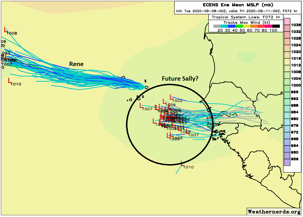
The map above shows the number of European ensemble members that have this disturbance emerging and beginning to develop by Thursday night. The National Hurricane Center has 70% odds on this disturbance developing within 5 days. It seems likely that we will have a depression or Tropical Storm Sally by the weekend.
So where does this go? Well, you can see on the map above that this system may emerge farther south than Paulette or Rene did. That’s important, as it provides the system an opportunity to come farther west before beginning the “out to sea” curve process. If this system develops strongly and quickly, it will have a better chance to find an escape route into the open Atlantic than if it struggles into next week. In that latter scenario, the system could perhaps find its way as far west as the Lesser Antilles before having a chance to turn more northward. That’s a solid week away at least, so a lot can change between now and then. But in general, if I’m rooting for this to avoid land, I’d rather see it get organized quicker than slower. We don’t think this is ultimately a Gulf threat, but there are enough ways it could become one that I suggest we check back in on this in a few days. Even if it did make it the Gulf, it would not occur until late next week or weekend at the earliest. We have a long time to watch this one.
There may be another system developing off Africa by next week as well, but it’s too soon to speculate on whether or not is has a future.
Anything homegrown to watch?
Right now, we don’t anticipate any homegrown systems to be of concern. With our cold front failing, that slight risk has basically been eliminated. There is Invest 94L off the Carolinas, but that is expected to track to the Carolina coast within the next four days, and it would likely not be a serious storm. There was a large blow up of thunderstorms south of Cuba yesterday, but that has completely dissipated today. The western Gulf has a good deal of wind shear overhead for a bit, so we are not worried about anything in the near-term.
2020’s statistics are weird
So, we’ll close with a quick note on where we stand right now in terms of how absurdly fast this season is moving. With Rene forming yesterday, it displaced 2005’s Rita (a true four letter word around here) as the earliest forming “R” storm. Rita formed on September 18, 2005, so we’re running about 11 days faster than the fastest on record. Interestingly, the record for earliest “S” storm is 2005’s Stan, which didn’t form until October 2nd of that year. So we’re going to be obliterating 2005’s speed records. We are not going to be obliterating 2005’s intensity level, however. Laura is a prime example of why it’s foolish, really, to focus on any one metric to quantify a hurricane season. That was an awful, awful storm, so who cares if the rest of the season had a bunch of middling storms?
2020 keeps churning out tropical storms and maintains a commanding lead for the year-to-date record.
But average storm duration and intensity remains low, and as ACE climatology ramps up fast during peak season, 2020 now sits at AVERAGE. This is pretty crazy. pic.twitter.com/BtitVwjhBL
— Sam Lillo (@splillo) September 7, 2020
Alas, we need some way to quantify a season to place it in historical context, so accumulated cyclone energy (ACE) is one of the best ways. And as of yesterday afternoon, despite already being at 17 named storms, we’re merely at “average” for ACE. You can see from Sam Lillo’s chart above how much of an outlier this year is at the moment. 2005 had about 2 to 3 times the amount of ACE, despite fewer storms to this point. 1933 and 1995 (along with 1893) sort of stand alone, however. Whatever the case, it’s been Laura and everyone else so far this season.Hopefully it stays that way, but there’s a long way yet to go.
“So, we’ll close with a quick note on where we stand right now in terms of how absurdly fast this season is moving.”
Yeah, but there have been at least 3 BS “wish” storms that lasted less than a day and were a stretch to be named anyways. We are not as far ahead as some of the dreamer at the NHC would like to think we are.
Thanks for your professional opinion. I’m sure NHC will be seeking your CV post haste.
You’re welcome. When they use the words “unbelievable, “unprecedented,” and “incredible” for almost every storm, it becomes the little boy who cried wolf. That is why SCW is so awesome — NO HYPE.
I mean…I don’t get this line of thinking, and I see it from a lot of people. A storm is a storm. All of the storms classified by NHC have met the definition of what a tropical storm is. Whether you think it’s pretty or not, it’s still a storm. And it counts. So yeah, we are able to name more than we did 50, 75, 100 years ago, of course. But it’s not like this season is BS. We’ve legitimately had 18 named storms, whether you or me or anyone else approves of it or not. Have most of them been weak? Sure. But it doesn’t make the record any less meaningful or impressive.
I respect your opinion, I just don’t agree. There is way too much hype in pretty much everything these days.
I don’t understand your disagreement, here. A standard is a standard. Either the storm met the criteria or it didn’t. This isn’t a subjective determination: it’s derived from actual measurements. Are you saying that NOAA is spiking their data? That’s a serious accusation, and I’d very much like to hear about why you think that.
I’d understand disagreement with the specifics of the standard– if you think that the windspeed threshold is too low, or you think there ought to be additional criteria– but not with whether the currently-defined standard is met.
Yes…a standard is a standard, but I am not a fan of not having any direct observation (i.e. hurricane hunter, etc.) scouting a storm before naming it. We have had a few of these weak storms called storms without that direct interaction with it. It leaves way too much room for speculation…especially with the hype factor turned to 11.
Amen to too much hype in everything these days
Creating false expectations is bad for everyone. Just watch nightly news- the stories they pick, how they are presented, voice inflections, speculation presented as fact and on and on
John B
With the increased number of reconnaissance flights being conducted by various organizations (AF Reserve, NOAA, ???), it’s a lot easier to actually investigate, measure, and identify storms — whether they get past tropical depression/storm status and become hurricanes or not. Not to mention shipping traffic with electronic radar/telecommunication systems that allow for detection and reporting.
It wasn’t that way when my dad was flying Hurricane Hunters out of Kindley AFB in Bermuda (1961-1963). Their motto “PRO BONO PUBLICO”.
The NHC is actually pretty conservative when they upgrade storms. Many storms get officially upgraded after the season is over after post-analysis is completed
I think I get their thought process, but your counterpoint highlights the problem with it.
I compare it to sports. Was that lineman holding? Did that shooter charge? Yeah, they were and did. But the hold was released so quick it didn’t impact the play; the charge was incidental contact. The ref makes the call because the league is trying to steer behavior or the ref is exercising outsized influence. Either way, the call is a legitimate violation but it gets in the way of the competition – which spirit the rule was trying to protect.
Same way, NHC is naming storms that really don’t meet the spirit of what it means to be a named storm. It’s a ticky-tacky call that just shouldn’t have been made. NHC, for whatever reason, is making a bigger issue out of a storm that shouldn’t have been.
But, as you point out, the problem is that we aren’t dealing with judgement calls. There are set targets and if you hit the target you get credit. Doesn’t matter if you only barely hit it for just a moment or if you are sustained.
Going back to sports, we don’t award fewer points for the ball that just breaks the plane, we don’t ignore the basket that bounces off the backboard and rim for several seconds before falling. It might help folks like that to think of naming that way.
At some point could you please explain why the storms originate off the west African coast? You may have done this before. If so, would you let me know where to read the explanation? Thank you. So thankful you guys give us great information.
When does the African wave train usually come to an end?
In the past I think SCW has pegged Sept 24 as the date when we can stop worrying about hurricanes here historically. Is that still the case this year? Your comments seemed to indicate to me that Houston might still not be out of the woods the last weekend in September (a bit beyond the 24th)…
I wish that storm names would exclude names like “Nana” which is a common name for grandmother. Does that mean they might use “Mimi” (my name from my grandchildren) or Grandpa etc etc?
What entity has responsibility for chosing Hurricane names/
World Meteorological Organization. If I remember right, the North Atlantic names are English, French, and Spanish. Nana may be a nickname for grandmother, but it is also a first name.
Storms are named according to a list that rotates each year, starting over every 7 years. If a storm is big enough, it comes off the list (Katrina is now Katia). Thinking back to my days of watching the Drew Carey Show, Mimi could join the list. But, until Melissa, Mindy, or Margot do some damage, you’re safe.
I’ve never heard of someone with the first name “Grandpa”, so I think that won’t happen.
My wife Sally will NOT be happy when the next storm gets named…me either…
Can they name it Mustang Sally or would that be considered an M?
We have to pay our penance of missing the cold front by that much, since we missed Laura by that much. 🤷🏼♀️