In brief: Houston will see less rain and more sunshine for a few days before healthy rain chances return Friday and perhaps Saturday. We are also closely watching the evolution of a tropical disturbance that should move into the northeastern Gulf over the next 24 hours. Although it is likely to remain east of Texas, the forecast is far from certain.
Invest 93L
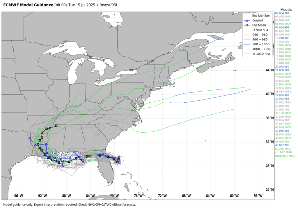
There has been a lot of chatter about a tropical disturbance, known as Invest 93L, which should move across Florida today and tonight into the northeastern Gulf of Mexico. The National Hurricane Center has increased the likelihood that this system becomes a tropical depression or tropical storm to 40 percent, but in reality we still have more questions than answers this morning.
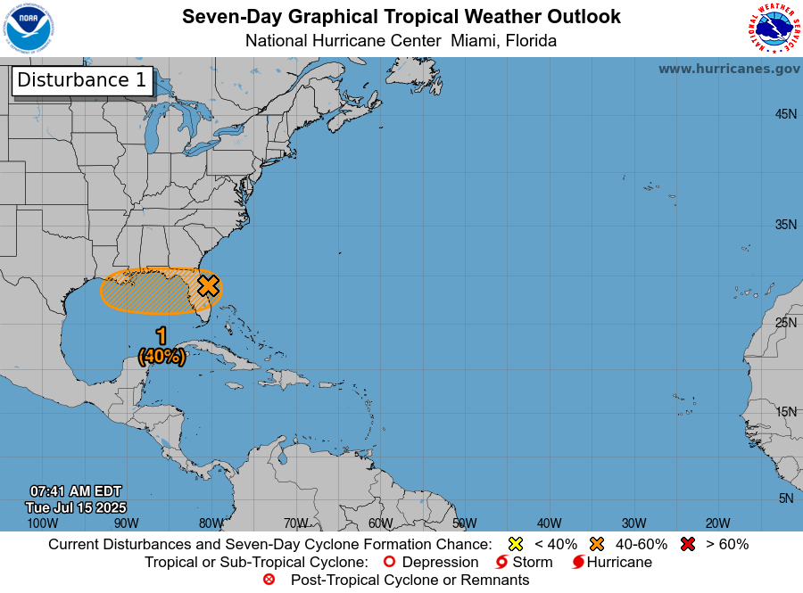
For example, if the bulk of this activity crosses Florida and then the ‘center’ remains anchored over the Florida panhandle rather than offshore, it has very little chance to develop. If the center (which I used in quotes above, because no center is as yet observable) remains offshore then there is a better chance for this system to organize a little bit. Regardless the majority of modeling still keeps this system weak, as a tropical depression or less. For now I am not really concerned about winds and storm surge.
The bigger issue is rainfall potential, and I think there are risks across the Northern Gulf coast, from Florida to east Texas. The majority of our guidance continues to indicate that southern Louisiana is at the greatest risk for heavy rainfall during the second half of this week, with flooding distinctly possible there, but we cannot rule anything out. As soon as we have some clarity about this system—which is unlikely until after tonight, when the disturbance crosses the Florida peninsula—we will share more. At this time, we believe Houston is unlikely to see major effects. But we’ll continue to watch closely and update accordingly.
Tuesday
The upper air pattern over the Houston region still favors some showers today, but coverage and intensity should be less than on Monday. Overall I expect rain chances in the vicinity of 20 to 30 percent today, and as usual we can expect a few areas to see some decent accumulations whereas the rest of Houston sees little to no rainfall. Skies will be mostly sunny otherwise, with highs in the mid-90s. Lows tonight will only drop into the upper 70s. Winds, generally, will be light from the south.
Wednesday and Thursday
As pressures rise a little bit, and our atmosphere dries out a little in terms of precipitable water, rain chances during the middle of the week should fall back to about 10 percent daily, so maybe just a few very isolated showers along the sea breeze. With mostly sunny skies, these days should see highs somewhere in the mid-90s for most locations away from the coast. Nights will be warm and humid, as one would expect.
Friday and Saturday
By this time we should see a surge of atmospheric moisture from the Gulf, partly related to the tropical disturbance. Because that system’s evolution is unclear, so too is our forecast for Friday and Saturday. However, the most likely outcome is that Invest 93L moves into the northern Gulf coast before reaching Texas. Even so, we should see some healthy rain chances on Friday, likely above 50 percent for the region east of Interstate 45, and perhaps a little lower on Saturday. Skies will be mostly cloudy on Friday, keeping highs in the low 90s. Saturday should see a bit more sunshine, so expect highs in the mid-90s. Again this forecast is written in pencil at this point.
Sunday and next week
By Sunday or so, we should see sunnier skies and (probably) lower rain chances for awhile. Most of next week should bring highs in the mid-90s for much of Houston, so fairly typical weather for late July when Houston usually sizzles, albeit perhaps a few degrees warmer than normal.

Again, birthday friday, so Texas is closed to storms. And thank you for your excellent coverage as per usual. My hopes are this thing, whatever it may be, is managable for everyone.
This is becoming my favorite subplot of this disturbance. We are rooting for you. Invest 93L: get OUT!
LOL you’re the best. Thanks for continuing to drag out my drama with me!
It seems like the sky is ‘closer’ than it was when I was a kid – that the storm clouds are heavier and closer than they used to be. Yesterday I was half-listening to the thunder and it all sounded ‘closer’ too.
Almost like the hydrostatic balance between the surface & the atmosphere is denser and pushed down more than it was 40 years ago.
You’re probably taller than you were when you were a kid.
Well, that’s definitely true…
“By Sunday or so, we should see sunnier skies and (probably) lower rain chances for awhile.” I feel like this whole summer we expect the rainy pattern to go away the next week but ultimately it sticks around after just a few hotter slightly drier days…not that I’m complaining.
Forecasting tropical systems strength and direction in June and July always seems to be worse than peak season. Could be because they’re usually weaker, also lack of fronts or stronger steering patterns. Not sure, but that’s been my experience.
These are the summers I remember in the 90s/early 2000s. pool/birthday party? storm rolls in, we shelter for about 20 mins with no clue what the radar looks like, then in 10-20 mins it’s done and back in the pool/in the yard playing. Hot, but not absolutely oppressive heat. Ice cream and popsicles and running through the sprinkler with the radio on and Slip-and-slides on the lawn with water balloon and super soaker battles. Nostalgic for the days where we didn’t always have to be plugged-in, but I know that public safety has massively increased as a result of giving great to-the-hour weather forecasting.
Also DQ needs to bring back the brownie earthquake.
Yeah, that’s how most summers used to be back then. However, 1998 and 2000 were one of those brutal oppressive summers similar to what we get today.
Visiting friends in South Carolina and of course we are scheduled to DRIVE back home on Friday and Saturday, stopping over in Picayune. I will be keeping an eye on this to see if we need to stay a day or two longer. Hopefully it will blow through quickly, but I’m no meteorologist so I’m grateful for this information resource.
What? No spaghetti model showing a direct hit on Houston? Something’s wrong…. time to get nervous… especially in Katy.
No lie 🤣
Idk about yall, but I am loving the way these forcasts for brutal heat and sun this summer have wound up not materializing and turning into rainy cooler weather. It is usually the other way around.
I have been here long enough to sense 93L is going to do a “Harvey” (a meteorological term for a storm that bounces off the Gulf Coast until it finds Houston, Texas). (And kills electrical power for millions)
rwong.
Lol, that’s good, I like that. It’s phonetically better, too.
July 15th
Record high: 103 in 2000
Record low: 64 in 1900