In brief: Francine remains a strong tropical storm this morning, and we’re beginning to see the turn from northwest movement, to northern movement, to northeast that will ultimately carry the storm well away from Texas. Local impacts, for many not along the immediate coast, will be difficult to discern from a regular late summer-day in Houston.
Francine status and forecast
The overall forecast for Francine remains much as we have been saying for a couple of days now. The tropical system will remain well offshore from Texas, and effects for most of our area will be minimal. In fact, I would go so far as to say that by tomorrow people in Houston will be going, “Hurricane? What hurricane. This was a joke.” Well, people who didn’t know better will be thinking that at least—but not readers of this site.
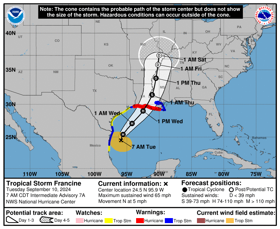
Francine will not be a joke for southern Louisiana. The tropical storm has sustained winds of 65 mph, and is likely to move inland Wednesday afternoon or evening as a Category 2 hurricane. The state’s most populated area, from Baton Rouge to New Orleans, will be directly impacted with winds, rains, and storm surge. For complete coverage of these impacts to Louisiana, be sure to check our ongoing coverage at The Eyewall later this morning.
Tuesday and Wednesday
There are showers just offshore the Texas coast this morning, and the question is how far rains from Francine will penetrate inland into the Houston metro area today and tomorrow. The answer, I think, is not all that far. Based upon high resolution modeling, I expect to see a band of showers reach the coast around noon today, and then fall apart fairly quickly as it moves inland. Then, the region will see scattered rain chances through Wednesday evening. All in all, I could see the coast picking up 1 to 2 inches of rain, with inland amounts significantly less. Areas such as Katy or Tomball may not see any rain at all.
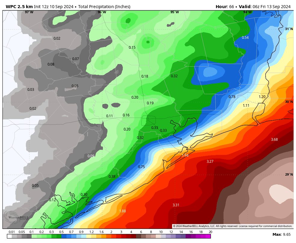
In terms of winds, I don’t expect much. If anything, the eventual track of Francine has pushed further to the east over night, and this really keeps the stronger winds at bay. We could see gusts of 25 mph or so in the city of Houston by Tuesday night, and perhaps 30 to 40 mph along the coast. But I don’t expect conditions seriously worse than this, and these kinds of winds will be fine if you need to be out and about. Seas will rise 1 to 3 feet above normal at high tide for coastal areas, including Galveston Island and Bolivar Peninsula.
The bottom line is that, for most of the Houston area, you won’t be able to tell there’s a hurricane passing offshore today and tomorrow. Skies will be mostly cloudy, with highs in the mid-80s, which is cooler than normal for this time of year. Perhaps that’s our greatest takeaway from this storm, some slightly cooler days. I’m not complaining.
Thursday
We may see a few lingering showers on Wednesday night, but by Thursday we should see sunny skies and light, northwest winds at 5 to 10 mph. Highs will reach about 90 degrees.
Friday, Saturday, and Sunday
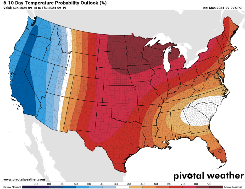
The weekend looks hot and partly to mostly sunny. Daytime temperatures will get into the low-90s for most locations, with nighttime temperatures in the mid-70s. If I squint I can make out a slight chance of rain returning to the forecast by Sunday, but it is probably only in the vicinity of 10 to 20 percent.
Next week
I don’t see much of a pattern change next week, as highs should remain in the low 90s, with low-end rain chances and plenty of sunshine. This is fairly typical, if slightly warmer than normal weather for mid-September, and should be good for the pool, beach, or whatever outdoor water activities you care to partake in.
Next update
We’ll have a brief update on Francine later this afternoon. Don’t expect any significant track changes that will impact Texas, however.

Thanks Eric! Looks like we dodged this one!
I slept well last night because of these guys. You said last night that you didn’t expect for it to affect us much and once again, you were spot on and without the drama!
Thank you!
We appreciate your trust.
May God protect all life, homes, business of our good neighbors and also the animals, in Louisiana.
An even more powerful reason to be thankful for cool fronts in September!
I can’t wait for the cool fronts! When in September does our risk of being hit in Texas sharply drop off? Thank goodness we dodged this bullet!
I was curious about this myself and looked up all the major storms that hit Houston, it seems like once we reach around 9/15 to 9/17, tha’ts when we can relax a little. We rarely have any major storms hit us late sept and beyond.
I came to same conclusion when I did a little research. We are almost there!
Going off memory, but I think the SCW guys have it pegged on Sept 24
Have you guys posted the predictive models? I like the spaghetti ones.
Hurricane?? What Hurricane??? Great Job!!!
You realize that if Eric and Matt get kudos when the storm goes away, they also get the blame when it hits us.
When a hurricane hits Houston, someone’s to blame? ok…
Thanks for your good work, guys. You’re one of the best parts of this crazy place.
These reports help so much, with every storm. Thanks guys 😊
As a connoisseur of humidity, I am very thankful for the dramatic change in air moisture we experienced between Saturday and Today. Any good steward of air moisture content knows that joy is derived from ~change~ in what we experience; we must know the highs to love the lows.
Would Francine’s track been different had the cool front trough not dipped into the Houston area?
Probably so because the cool front stalled out offshore and is helping to steer the storm into Lousiana. Had the front continued shifting northward back onshore over Texas we could have a problem on our hands.
I was thinking the same. We totally lucked out because, as we all know, early September cool fronts are pretty rare.
Lack of direct impact won’t stop Centerpoint from handling this the way Notre Dame handled NIU last week.
While I’m glad that we’re dodging this one, Louisiana isn’t so lucky. Since they cannot avoid it, I wish them a short visit by Francine.
No stalling, no dilly dallying, hopefully it will move quickly inland and spread the rain further inland.
Historically speaking it is pretty rare for the same location to get hit twice by a hurricane in one season so that has been helping me relax more. It has happened before in the past but it is very uncommon.
Just a pet peeve of mine… not you but one local forecast in particular seems to favor using the water vapor radar, I guess is what it is called, when showing these tropical systems out in the gulf. Sometimes it is not mentioned or probably goes unnoticed by the layman. Then they show the rainfall radar on a day to day basis. The juxtaposition between the two can be quite alarming and cause unnecessary anxiety. There, I said it.
This is all because I bought a generator after Beryl!
Rest assured, you’ll need it eventually.
Thank you for your service!
Any modeling available for the other two systems in the Atlantic?
💓thank you cool front💓
As with all storms the real question is should Katy start evacuating?
Always…even without an approaching storm.
Katy needs to just abandon itself at this point😂🤣
We lucked out but hoping that the folks in Louisiana will manage OK. They seem to get a lot of hurricanes there.
Why does NWS still have SE Texas (even far inland) in the cone for tropical storm force winds?
I’ll believe we dodged a bullet when this thing actually makes landfall. Lesson learned from the daily, if not hourly, landfall forecasts during Beryl. Mother nature has a mind of her own.
Por favor, could I get the weekly rain in the URBAN CORE this week ? Awfully dry here.
Seriously? I’m inside the loop and have gotten >2″ of rain in the past week or so. This year has been much better for precipitation, especially compared to last summer.
Ok. Precipitation has been scattered. Maybe an 1” total last week in 3 days of very light showers here. Seriously. Dust clouds.
I’m on the south side between BW-8 and 610, and we seriously got less than half of an inch over that ten-day wet period.
The ghost of Sam Houston must have slid off his barstool at La.Carafe and waved his dueling pistol at this storm to keep it away. We were so lucky. ..