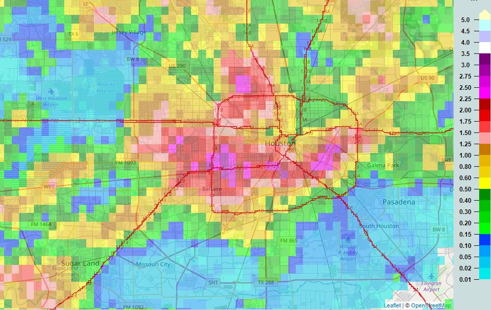
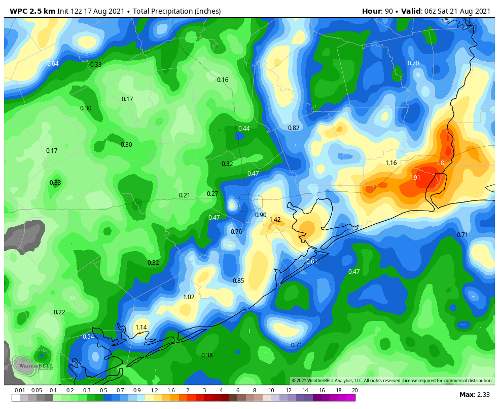
Some areas along the Southwest Freeway and Loop 610 saw very heavy rainfall on Monday, with storms briefly producing about 1.5 inches in 15 minutes. While overall totals for much of this area were only 2 to 4 inches, the intensity of this rainfall nonetheless produced significant street flooding. This is a testament to the power of rainfall rates, which are just as important as rainfall totals. A rate of 2 inches per hour, or more, will quickly back up streets. A healthy chance of rain will remain until the weekend, when high pressure should yield more sunny skies across the region.

Tuesday
Skies should be partly to mostly sunny, with highs pushing into the mid-90s. High resolution models indicate that storms should again form in the metro area this afternoon and evening, before waning around sunset. I suspect about 40 percent of our region will see showers, with storms likely not as intense as on Monday. Winds will be light, out of the southeast at 5 to 10 mph.
Wednesday
Slightly higher moisture levels and more of an impetus for rising air should lead to better rain chances on Wednesday, with perhaps 60 percent or more of the area seeing showers or thunderstorms during the afternoon and evening hours. Highs will probably slot into the low 90s, with partly sunny skies.
Thursday and Friday
These should be mostly sunny days with highs in the mid-90s. Afternoon shower chances will remain, with perhaps one-third to one-half of the area receiving some rainfall each day.

Saturday, Sunday, and beyond
As high pressure establishes itself more firmly, rain chances will fall back to about 20 percent for this weekend. As rain chances fall, temperatures will go up, and I expect a hot weekend with highs pushing into the upper 90s for inland locations. This hot and sunny trend likely continues into next week with August-like weather for our region. The good news? August is now more than half over, my friends.
Tropics
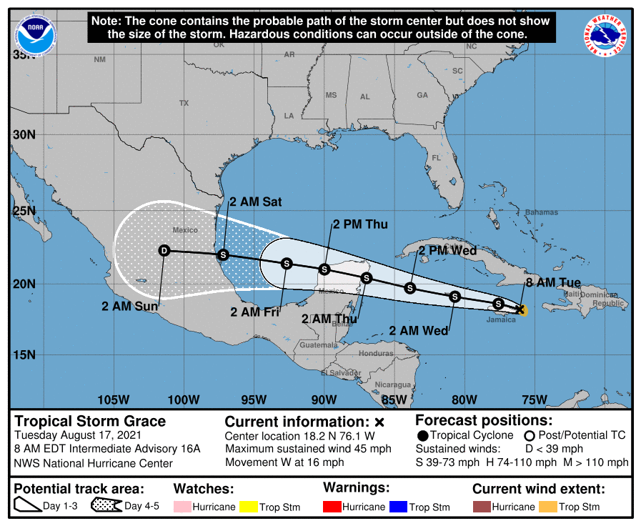
There are three named storms active in the tropics this morning. Tropical Depression Fred has moved inland into the Southeast United States. Tropical Storm Henri is swirling around Bermuda, and will stay away from the United States. And then there’s Tropical Storm Grace, which is nearing Jamaica. Confidence is now high that this system will continue traveling due west, across the Yucatan Peninsula, into the Southern Gulf of Mexico, and ultimately into Mexico. It is not a threat to Texas.

After these three storms we may see a bit of a lull in activity—but no promises as we’re in the middle of August.
Well, missed the rain again basically. 59/Kingwood had, at most, .05”. I am very sorry for those who may have flooded as that has happened to us 2 times in 2019. If we had 2+” fast we would most likely had flooding problems as the ground is brick like now. We need a slow soaker to change that. Hope the localized rain will be over us next and not just “near” us. All this leaves me to wonder about micro climates and the how and why it rains there but not here. Why rains clouds shift around so much in an absence of a front.
“It is not a threat to Texas.” Sweet words, indeed, although I do feel for those south of us who may be adversely affected.
I was in that hotspot in the Galleria area. It was pretty intense and awesome how fast that rain came down. We had street flooding that persisted for about 1.5-2 hours and unfortunately swamped at least 4 cars in our area alone. Hard to know why those people took that risk but if we could just learn to hunker down, find some high land, and wait, that’d be great.
I live near Weslayan and Richmond, and it was worse here than we ever got during Harvey! My wife was out at physical therapy, and the rain was forecast to keep going for an hour, so I drove the half a mile to pick her up, then tried to get back home via Cummins St…..the car made it all the way but it was really scary. Should have just waited.
Have to wonder how much the Houston area is affected by the amount of heat radiating off of all this concrete around here. Concrete creates an insulation barrier on the Earth, containing heat inside while also absorbing heat itself from the Sun. I’ve noticed more intense storms but not saying it’s related directly to that, but there’s something there.
Hi Justin, this is a pretty good, small study on heat islands. It’s in WI so no quite the same as HOU but still informative. https://wsc.limnology.wisc.edu/research/urban-heat-island
The heat radiating off all the concrete in cities act as a storm magnet.
Concrete is definitely a factor in storms. I’ve watched impending storms approach on radar and then once they hit the loop, they either blow up or completely disappear. Dependent on the heat of the day, etc., the concrete in that area is either a catalyst or a dampener. Yesterday it was a catalyst.
Dude, driving home to Montrose from 59 and Chimney Rock at 4pm was NOT fun. I couldn’t see the street for quite a while, but was lucky and passed Richmond and Montrose before it got really bad. My courtyard flooded at home. Not a fan. Here’s hoping it’s not like that today.
Any potential rain coming from GRACE as it passes by our South this weekend?
This has got to be the wettest and coolest summer we have had in a long time. I cannot remember this much rain consistently over a month or 2 month period in the summer.
I’m with you Wayne…in Clean Lake sure seems it’s been wetter than I remember experiencing in the summers since early 70’s…grass loves it!
Enjoy it…the Dome of Dry is over my house and immediate area 59/Kingwood dr. Brown and burnt where no watering is happening. Just amazed at how much difference there is in a few miles! Sometimes like yesterday we had lots of clouds and lightning so it was cooler, at least! The rain gauge nearest us which is less than 2 miles as a crow flies had .52”! Sigh…..
The Summer of 2007 was cool and wet. I remember a lot of average soakers.
I’m pretty sure there was not a day it didn’t rain in summer 2007. Certainly felt like it
What is the possibility of Grace crossing Mexico, entering the Pacific, and restrengthening?
Slim, but not 0. It’s certainly a thing that has happened, but there’s a lot of mountainous ground to cross over.
Henri: Bermuda or Bahamas?
Come on pretty mama….
im counting down the days until its September
GFS showing something interesting things toward the end of next week