In brief: After a few mostly cloudy days we’ll see increasingly clear skies and this will help temperatures march upwards. We’ll go from highs in the low-90s today, to mid-90s this weekend to upper-90s by Memorial Day. After that a weak front will provide some modest relief.
Thursday
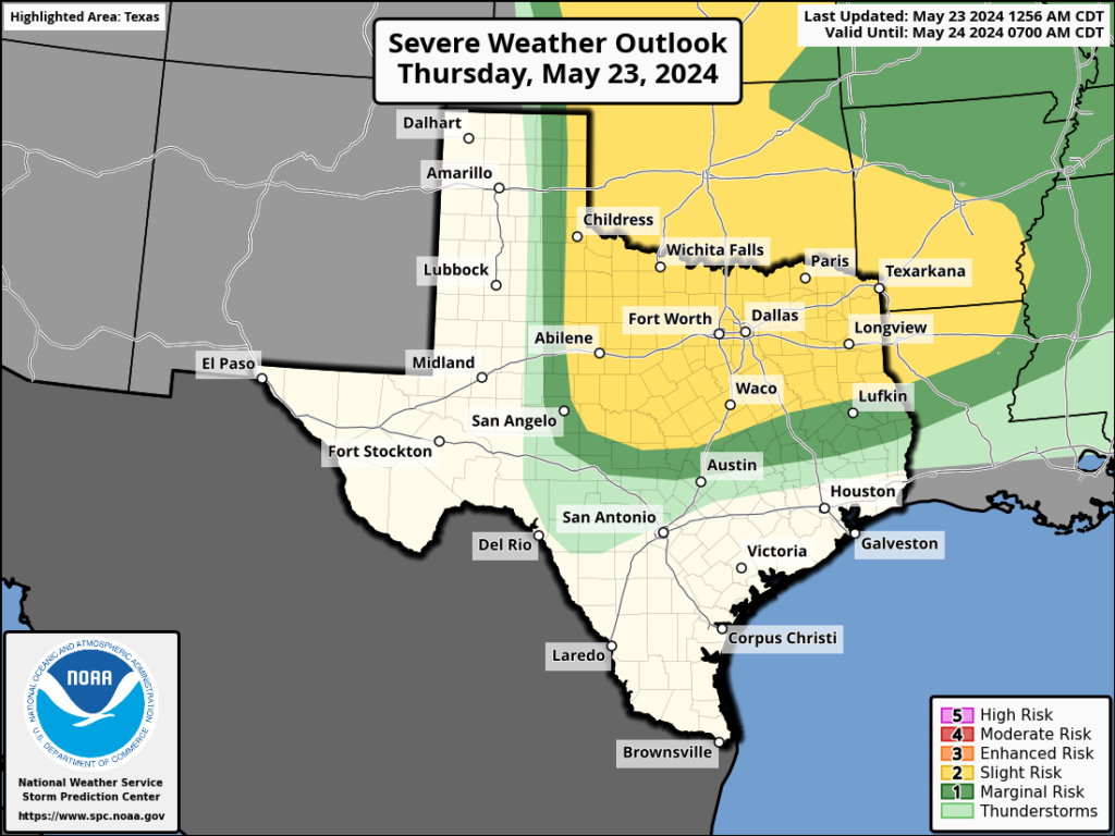
After a cloudy start we should see partly sunny skies this afternoon, and this should help to push high temperatures into the low-90s. Winds will blow from the south at 10 to 15 mph, with occasionally higher gusts. Once again, we should see some fairly strong storms develop in central Texas to the north of Austin. While these will propagate eastward, I expect them to remain north of Highway 105 once again, with no impact on the greater Houston metro area. Low temperatures tonight will only drop into the upper 70s.
Friday
A day very similar to Thursday, although high temperatures are likely to be a degree or two higher.
Saturday and Sunday
We’ll see mostly sunny skies this weekend, with high temperatures solidly in the mid-90s. We will be hitting our first highs above 95 degrees nearly three weeks earlier than normal, in case you were wondering whether this is typical weather for late May. It’s not. Nighttime lows remain sultry, around 80 degrees.
Memorial Day
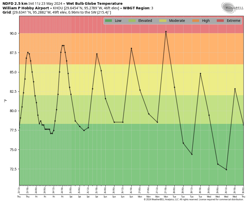
Everything comes together on Monday, sunny skies and the characteristic jump in temperatures associated with an approaching front, to push our highs into the upper 90s. If we look at wet bulb globe temperatures—a measure of heat stress in direct sunlight that takes into account air temperature, humidity, wind speed, sun angle, and cloud cover—we see the potential for an ‘extreme’ day in terms of heat. Please bear this in mind if you have outdoor activities planned.
Tuesday and beyond
We’ll see a slight chance of rain on Monday evening as the front approaches and moves through, but for now I don’t expect anything more than a dusting of showers. Highs next week look more reasonable, in the low 90s, with overnight lows perhaps in the mid-70s. We’ll also see some daily rain chances in the Wednesday through Saturday period, although they may be of the 20 percent daily variety. I’m not sure yet. In any case, the very end of May should see a bit of a return to normalcy.

So last year we got August in June, and this year we get August in May. ;_;
If we got August in May this year, I’d hope we could have September in June; October in July; and November in August. Then, align the months again in actual September.
But, I’d settle for “April” in the high summer months of June, July, and August.
Dream on, Jingle….
Look on the bright side,
…
of the scorching sun.
I’m glad to see the wet bulb globe temperature graphs lately—I hope that will be a regular feature!!
Are you REALLY going to feel that way by, say, late July? 🙂
It is also not typical to get a cold front late in May. In fact, that is why temperatures are going to soar this weekend ahead of the approaching front.
Was about to say! especially in recent years prior when once we hit 95 there was no looking back.
Aren’t you cute, calling it a cold front.😆
I remember Memorial Day weekend was my last chance to get the yard and outside of the house ready for summer “before it got hot”. Well, that’s mid-April anymore.
Why do you guys make of the increasing temperature in the MDR zone? Many have already stated that the current temp is what it would be like in August. Implying that we may have a more active hurricane season this year.
Record high water temperature anomalies in the mid atlantic along the equator are showing signs that we need to gear up for an active hurricane season. Better to be proactive and over-prepared than the opposite…
It seems the general consensus is we are in for a battering:
This on the BBC site today:
“The North Atlantic could get as many as seven major hurricanes of category three strength or over this year, which would be more than double the usual number, the US weather agency NOAA has warned.”
So, no excuse now for not being ready.
Upper 90s is not very common in late May but it isn’t unheard of. We have hit the upper 90s in late May multiple times throughout history. What isn’t normal is the 111 degree heat index they are predicting for Memorial Day as well as the overnight lows in the 80s. That isn’t even “normal” for July and August let alone May. The temperatures themselves is not the problem, it’s the excess water vapor release from the progressively warming gulf waters. This is what has been making it feel so unbearably muggy these past few summers. Parts of Florida just experienced their highest heat index values on record because of this issue. I don’t want to even think about how bad it’s going to get here in the coming years and decades. They are predicting that by the 2050s we will probably hit heat index values of 125+ on a regular basis during the summer months here in Texas. At the rate we are going, it will probably happen even sooner than that. The Northern States are going to see a surge in population growth as people in the south are going to flee up north in the coming decades.
I’m thinking it’s going to be an average summer. Hot and humid but high pressure is going to camp east and west of us keeping a strong flow from the gulf all summer. Nothing like the summer of death we had last year. I am basing this forecast on absolutely no evidence other than a gut hunch so I would not sell your water sprinklers or anything…
I concur, good sir. hopefully we’ll see the return of the short 15 minute sun showers every few days. I really miss those, even if I did get caught in them.
We’ll likely get more rain this year — in the form of constant hurricanes and tropical storms. Don’t expect the record-breaking heat to lay off much, though. Last year’s heat may have been an outlier compared to the preceding years, but it likely won’t be compared to the years ahead.