Since there’s not a whole lot new to discuss today, I spent a little time looking at statistics from Hobby Airport last night. So far this June, the airport has registered a heat index of 110° or hotter for 18 hours. That may not sound like much, but consider that no other year in the 2000s has come close to this many hours of extreme heat in Houston, at least at Hobby. Not even the infamous 2011 summer. The most recent challenge to this year is in 1998, when we managed 32 hours of 110° or higher heat index values, almost all in July and August. 1997 saw 19 hours. 1982 saw about 22 hours. The infamous summer of 1980 had a heat index of 110° or higher for 16 hours in June and then another 14 hours in July. We will see if the coming weeks will have us challenge 1980 and 1998 for supremacy, but regardless, it’s just dang hot.
Today through Friday
Surprise! It’s going to be hot. High temperatures will be near 100 and lows will be near 80 degrees through the end of the week. For today, we have a heat advisory in effect, not an excessive heat warning — for now. That may change through the day. But at least it signals the chance that it may feel just a tiny, miniscule, itty bitty, small bit less oppressive. Either way, we encourage maximum heat precautions today through Friday with continued persistent heat and humidity.
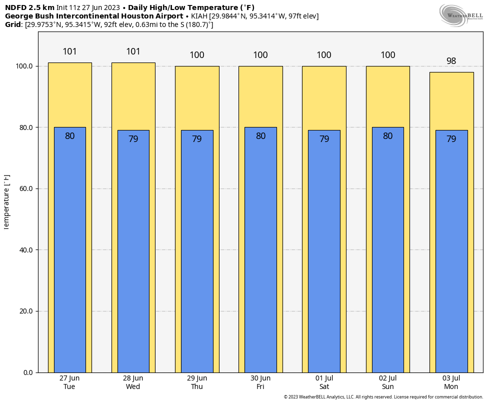
For those curious, rain chances the rest of this week remain at roughly zero point zero percent.
Weekend
We’ll maintain persistence through Saturday, with more hot and dry weather. Sunday should, should mark the beginning of the transition out of this pattern. Rain chances may increase to a whopping 5 or 10 percent Sunday, but more importantly, the upper air pattern will finally start to break down, signaling changes next week.
Heat break next week
There is good news and bad news beyond the weekend. The good news is that the heat should reduce to more average levels for early July next week. For those that have forgotten, that means highs in the low to mid 90s each day, lows in the upper-70s, and heat index values in the slightly less extreme 100 to 105° range.
Additionally, it means rain chances return to the area. Yes, this could mean a chance of showers or storms on Monday and Tuesday afternoons for the holiday, but it should at least mean some relief. We’ll hone in on specifics later this week.
The bad news? There are signs in our modeling that the heat over Texas may try to make a comeback after next week. But that’s still a long way off.


The heat is about to be like LL Cool J next week, don’t call it a comeback I’ve been here for years
Yesterday was the first day without any rain in several days. The heat doesn’t feel particularly extreme to me. Just normal Houston summer
Perhaps you are acclamating to the heat. The reality is that the more one spends outdoors in these conditions – within reason of course, the more one can tolerate it.
Frog-in-pot syndrome.
I gather that the 18 hours @ 110+ is cumulative, as is the record of 32 hours, with just a few hours per day but over a large number of days. So what’s the record for continuous hours @ 110+? Does any particular day stand out?
Your assumption is correct. As for any single day standing out? That’s a good question, and not one that I can answer offhand haha. But my guess is that most days with 110+ heat indices will only hit that level for 2-4 hours max.
Seems like the heat index at Sugarland airport has been off the charts compared to Hobby and especially Intercontinental.
The reporting of the heat index has been odd lately, and I can’t fully explain why. I feel most comfortable with Hobby truthfully. This is partially why I have tried to gently introduce the wet bulb globe temperature concept to the site because it’s more qualitative in how it’s explained and frankly seems more useful.
Matt, is there any correlation between the years we have had extreme heat and hurricane activity in the Gulf of Mexico?
Not particularly. I think if anything there’s a loose correlation toward fewer storms in hotter summers, especially in the western Gulf. Of the years I noted today, 1980 saw Hurricane Allen (which did briefly become a cat 5) hit South Texas as a Cat 3 storm. But that was the only one. So the answer is that there isn’t much correlation, but storms can happen in hot summers.
I would think that when there is high heat, it is usually due to high pressure domes, like what is going on right now. Tropical storms don’t like areas of high pressure. Storms are drawn to areas of low pressure and tend to track towards it.
I still favor the nuclear option w.r.t. the heat dome.
“Zero point zero” in Dean Wormer voice.
Lived here all my life so heat waves are just part of the ongoing Texas weather saga. I think what sticks in my mind is the frequency of occurrence. My son asked me when was the last time we had heat waves. Instead of saying we had some 10 years ago I said…uh..er…last summer. Wow. Back-to-back misery. Hope our June heat wave ends this Friday on June 30th. That way we can start our July heat wave on time! 🙂 David in Houston
It’s been hot and humid, but not terribly so. Thankfully, the forecasts have been a good bit hotter than the actual temperatures. I’ve hit 100+ (99.5 or above) only 6 times, with a max of 101. Had the forecasts verified, I should have maxed out at 104 with at least 15 – 20 days at or above 100. I think the models, GFS in particular, have a fever. As a result, people think it’s worse than it’s actually been.
Is that temp reading excluding heat index since that is what is being focused on? Also explain your logic to those who have to work outside or have issues with AC, you might get a different response
I’m comparing the forecasted high temperature to the actual high temperature. The heat indices, as usual, are much higher than the actual temperature. I’m not sure why you’re mentioning logic. I simply stated that the actual temps have trended a little lower than the forecast highs on most days, and that’s a fact. Furthermore, FWIW, I’m working outside in the direct sun for hours several days per week (not as a paid job…just doing stuff around the house or country place). I never said it wasn’t hot outside. Believe me, it is.
I think the big deal is how early this is for this level of heat. The normal average temperature in Friendswood for June is low to mid 90s. Not 97-100. July and August are usually worse temperature wise…And if that is what we end up seeing…