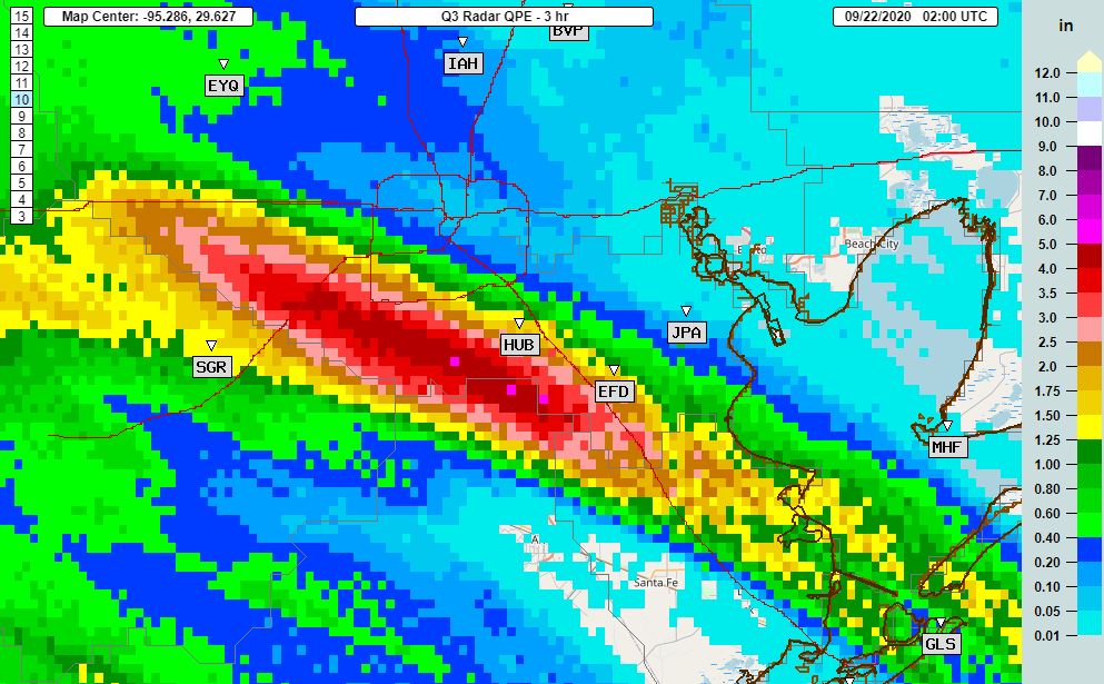
Good evening. Training bands of moderate-to-heavy rainfall from Tropical Storm Beta are continuing to move across the greater Houston area this evening. The heaviest rains from 6 to 9 pm fell generally to the south-southwest of Houston, from Friendswood and Pearland through Sugar Land. A few locations received 4 to 5 inches during this three-hour period and it is starting to back up bayous. Other parts of Houston have largely been spared.

These southern areas appear to have won the Beta lottery this evening with a nearly stationary banding feature that is continuing to feed off moisture from the Gulf of Mexico. The National Weather Service has issued a flood advisory for this general region, suggesting an additional 1 to 2 inches of rainfall may occur over the next several hours. So far, the vast majority of area bayous and creeks remain within their banks. According to Harris County Jeff Lindner, here are the waterways of most concern at the moment:
- Lower Keegans Bayou: overbanks at Roark…flooding is ongoing
- Willow Waterhole: near bankfull at Westbury
- Brays Bayou: water levels are within 2-5 feet of bankfull from Gressner Dr to Rice Blvd
- Clear Creek: Near bankfull along the entire channel and overbanks near I-45
- Turkey Creek: Within 3 ft of bankfull at FM 1959
Waterways aside, these heavy rains have created a dangerous situation on some area roadways. Tonight is not a great night to be out and about.
My read on the radar is that this prolonged banding feature that has been running up the Gulf Freeway for much of today and this evening, and ultimately bending into Sugar Land and now west Houston, is running out of steam. Offshore, the next band appears to be developing slightly to the north and east, and if this happens it should give some of the region’s aforementioned, hardest hit areas a reprieve in an hour or two.
Our next post will come by or before midnight to see whether I have read the radar correctly.
Thank you for everything you do.
You guys are awesome. Thanks.
Thank you Eric! We REALLY appreciate the multiple reports! I keep reminding myself this is not Harvey and the rains will move on. Thanks for keeping tabs on Beta.
Ditto to the gratitude for multiple updates this evening. Greatly appreciated, Eric.
What are the Wind speed forecasts in Matagorda & Brazoria Counties for Beta once it stalls inland on Tuesday?
Previously you had posted a helpful wind profile map.
Thanks !
Thank you for keeping us informed.
Y’alls sleepless nights allow all of us readers to sleep well! Your a blessing to us all!!!
Praying for a reprieve in SW Hst… thanks
Your email frm 8:48 this evening incorrectly refers to Rice Blvd when it should say South Rice Avenue.
Thank you Eric!
I think that I will go and check out Bray’s Bayou this evening and see if the Flood District’s plan, and City’s “improvements” are actually making a difference…
I’ll post what I find.
Anything to report? Specific areas of Brays?
Eric you are not giving us the whole story. According to network news, Noah is already chugging up brays Bayou In his ark.
That’s NOAA, not Noah.
Yeah, we’ve been Beta testing our gutters here in Sugar Land.
Clear Creek at west nasa rd 1 and palomino is over the banks, flooding garages of homes
Beta has not been that big a rain event and yet there are serious problems in places. Looks like we still have lessons to learn from Harvey,