The National Weather Service said this afternoon that a Flash Flood Watch will go into effect for much of Metro Houston (basically along and north/west of US-59/I-69) beginning Friday afternoon and continuing through Sunday morning. This includes the areas hardest hit by last week’s flooding.
As Eric pointed out this morning, there’s good reason for this. Most bayous in the city (Buffalo Bayou an exception) are back at their baseline levels. But, outside the city, streams, creeks, and bayous are running a few feet higher than normal still. And with a soggy ground any additional rain is unwelcome and can cause flooding concerns depending on how quickly it falls.
Basically, at this point all you need to do is continue to watch the forecast. There’s a bit less certainty with this event than there was last week. Also, it can’t be underscored enough that the rain totals implied by all models with this event aren’t anything like the last one. We want you to be prepared but not to panic here. We still don’t know exactly where the heaviest rain will fall, but we know there will be a few spots that see a pretty substantial amount of rain (not 15-20″ like last week, but 4-8″ in a few spots isn’t impossible).
So just stay tuned in through the weekend, especially if you have to travel around the area or live in an especially flood prone spot. We will have you covered.
TONIGHT & FRIDAY MORNING
In the near-term, we have a somewhat challenging forecast tonight and tomorrow.
If you believe the European model, heavy thunderstorms will flare up directly over Houston overnight. It may be the gold standard of weather models, but in this case it’s gone rogue. Most other weather models indicate that the next 12-18 hours will see just a chance of a few showers or a thunderstorm. I tend to agree, as absent really any big trigger, anything tonight should be sparse and directed north and west of the area.
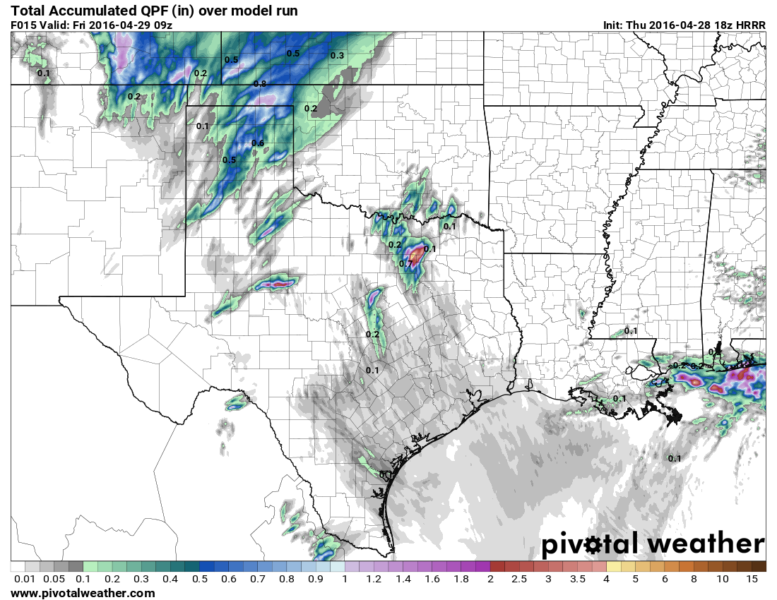
Here’s the GFS 24 hour total precip between 18z today and 18z tomorrow (1 PM-1 PM):

So, that’s basically in line with the forecast above: A few showers around.
Our best high resolution short-range model, the HRRR, shows limited precipitation in the area tonight as well.
So it’s essentially the Euro versus the world right now. I would stick with a “chance of a few showers” forecast tonight for most of the region, with the best chance for some thunder in the Brazos Valley up toward College Station. We’ll continue to watch.
Rain chances will slowly tick upward tomorrow and especially tomorrow night closer to Houston; that’s when the concern for heavy rain and flooding will ramp up. More on that in the morning.
Posted at 3:00 PM Thursday
Is there any web site/information source that regularly provides information on the depths and trends of bayous, creeks and reservoirs?
Thanks./
Ron: Yes. Harris County Flood Control has a great website and interactive map that allows you to view bayou data, rainfall data, etc. in near-real time. It’s a must-bookmark if you live in Houston: http://www.harriscountyfws.org/
And a great deal of thanks as usual!
1. Do you remain unconvinced that but we’re going to see the kinds of strong winds the we had on Wednesday morning again with the heavy rain this weekend?
2.I’m also worried about lightning. Does excessive moisture mean twice as powerful cloud-to-ground lightning?
In regard to both questions, we cannot rule out the possibility of some severe weather in the form of damaging winds and lightning. However I am most concerned about the potential for heavy rainfall.
Sorry to bother you again, Eric, but I’ve been told by an arborist friend that falling trees from saturated grounds do not need a lot of wind as they usually fall very slowly lifting up the lawn, while higher winds will snap branches and full size trees and but will also lay them down intact with the root structure exposed.
Now, does this mean we could STILL have thousands of homes without power even if the winds from the heavy rainstorms do not exceed say, 30 mph? I know it’s hard to predict, but what’s your best guess?
Yes, that is certainly a possibility. My best guess is that it won’t be total bedlam.
Thanks, Eric. Q.1 Any possibility to predict comparisons to Mem Day or Tax Day events?
2. When will we know whether the Euro model is truly a rogue ? Pop up showers to the west?
1. Yes. It almost certainly won’t be bad.
2. When models start to converge on a forecast outcome, then we’ll know whether the Euro is rogue or right (as is often the case).
Hi Eric! My dear Fulgencio has to drive from Dallas to Houston Saturday in the early afternoon. He has called me crying 5 times today. Is the forecast for Saturday any clearer so I can ease his pain? Thanks.
Be sure and check our latest. http://spacecityweather.com/houstons-threat-storms-kicks-today/
Too early to compare potential Saturday event to Tax Day or Memorial Day?
No. We’ve tried to be pretty clear that this rain event is unlikely to match those storms in terms of total precipitation.
OMG, Eric and Matt! This is the hazardous weather outlook:
.DAYS TWO THROUGH SEVEN…FRIDAY THROUGH WEDNESDAY
A FLASH FLOOD WATCH IS IN EFFECT FRIDAY AFTERNOON THROUGH EARLY
SUNDAY MORNING.
HEAVY RAINS WILL BE POSSIBLE FIRST IN THE WEST FRIDAY AFTERNOON
AND EXPANDING EASTWARD FRIDAY NIGHT AND SATURDAY. SCATTERED TO
NUMEROUS STORMS SHOULD FORM AND MOVE SLOWLY THROUGH THE REGION.
RAINFALL OF 2 TO 4 INCHES SHOULD BE COMMON WITH SOME AREAS SEEING
AMOUNTS IN EXCESS OF 5 INCHES. IN ADDITION A SLIGHT RISK OF STRONG
TO SEVERE THUNDERSTORMS WILL EXIST FRIDAY AFTERNOON AND NIGHT WITH
THE PRIMARY THREAT BEING GUSTY WINDS AND HAIL. WITH THE GROUND
BEING SATURATED A GREATER THREAT FOR TREES TOPPLING WILL OCCUR
FROM THE GUSTY WINDS.
That means people who didn’t lose their power on Wednesday WILL lose their power Friday/Saturday, right?!
Not necessarily.