In brief: Today’s post discusses today’s rain chances, and what kind of weather we can look forward to for the remainder of July. We also address the potential for a tropical disturbance to develop in the northern Gulf this week.
July has been mild so far
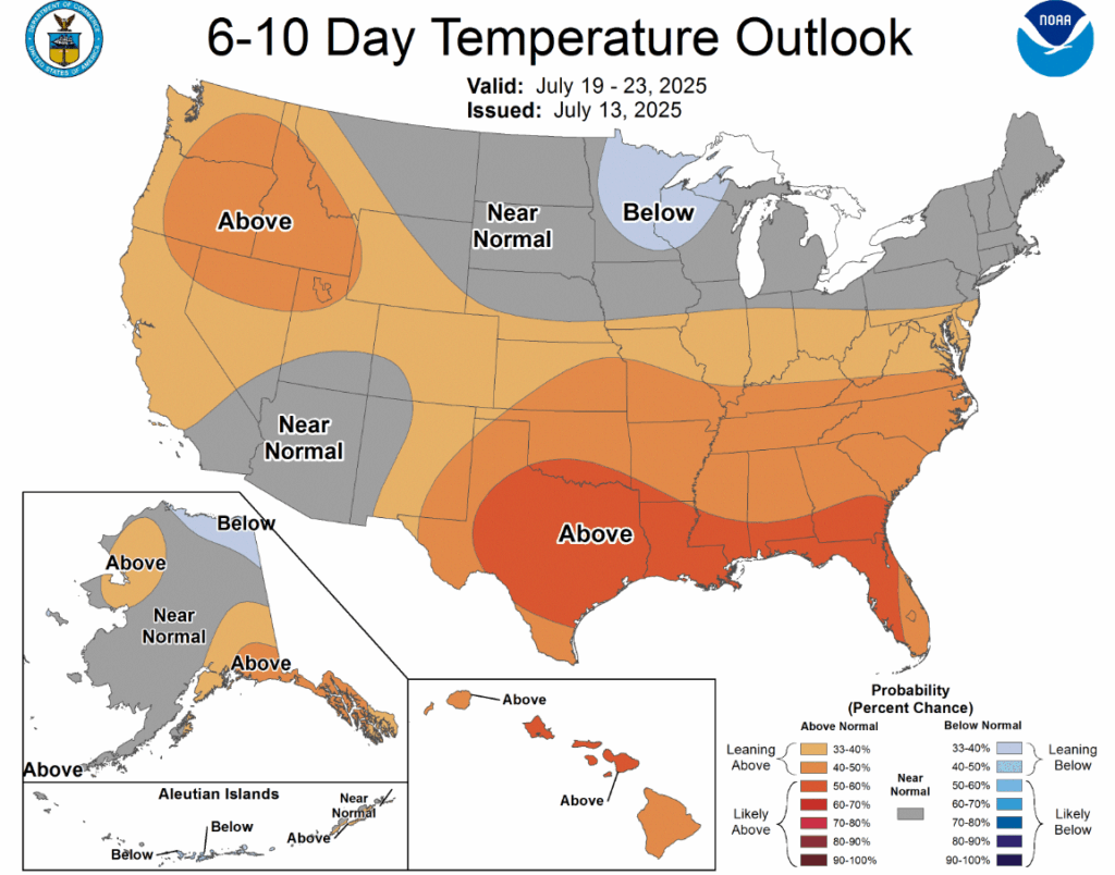
Don’t look now, but July is almost half over. Whether that is worth celebrating or mourning depends on one’s perspective. However, the next six weeks are typically the hottest period of the year in Houston. After a relatively mild start to the month so far—a majority of days have recorded highs of 95 degrees or below, the thermostat is going up. I think, from this point on for the remainder of July, we can expect the majority of days to reach 95 degrees or higher in Houston and for locations away from the coast. To be clear I don’t see a long string of 100 degree days. But we’ve reached peak summer, and it is going to feel like this outside.
Monday
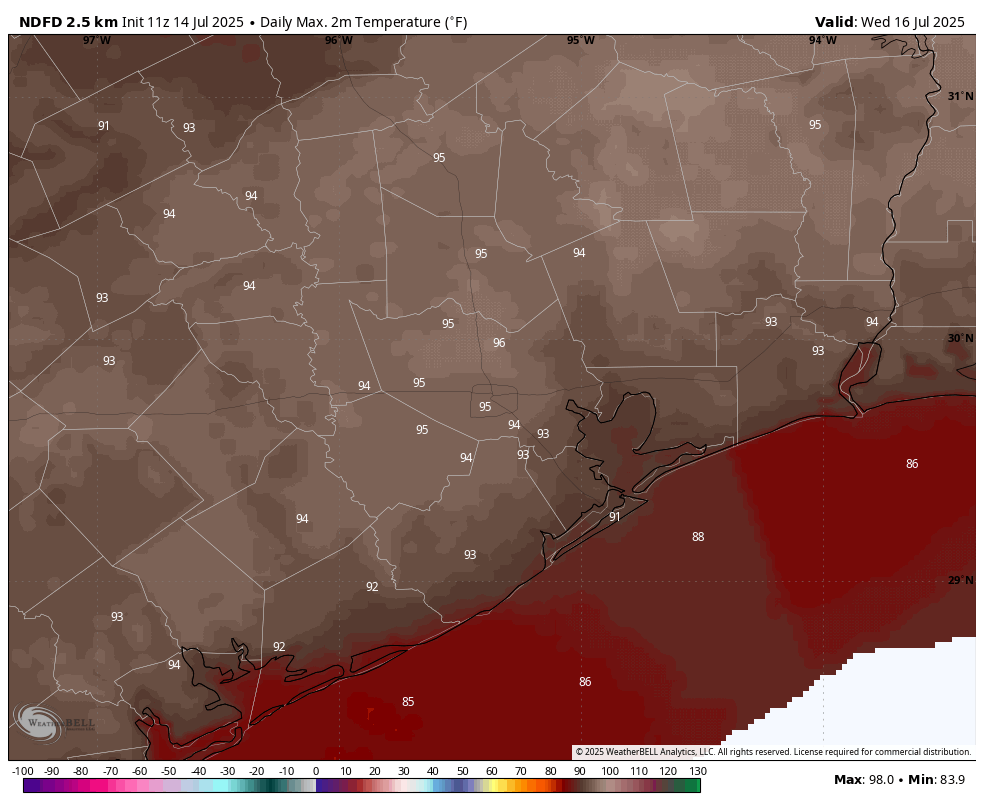
With a fair amount of atmospheric moisture and lingering low pressure, Houston will see a decent chance of showers and thunderstorms again today. Like for much of this past weekend, chances will be higher along and north of Interstate 10, but the entire region will at least have the possibility of seeing some storms. Once again, these showers will be decidedly hit or miss, with the heaviest hit areas picking up 1 to 2 inches of rain, and perhaps half the region seeing no precipitation at all. Skies will otherwise be partly sunny, with high temperatures in the mid- to upper 90s. Lows will fall into the upper 70s.
Tuesday
Rain chances drop back into the 20 to 30 percent range, with any showers likely to develop during the afternoon hours. Expect highs in the mid-90s with mostly sunny skies.
Wednesday and Thursday
High pressure will likely hold sway during the middle of the week, and this should yield a pair of sunny days with highs in the mid-90s. With dewpoints in the 70s it will feel plenty humid outside, in case you were concerned about the air drying out. (I think this counts as gallows humor in Houston). Anyway, it’s gonna be summer sticky like always in Houston.
Friday, Saturday, and Sunday
Our weather toward the weekend may be influenced by a surge of tropical moisture (more on this below), but how precisely this will impact us remains to be seen. I think we’ll see a decent to healthy (30 to 50 percent) chance of showers on Friday, and perhaps some partly to mostly cloudy skies. This might cool highs off into the lower 90s. How long this cloud cover lingers into the weekend is not clear, but my guess is that most of Saturday and Sunday are probably mostly sunny, with highs in the mid-90s. Rain chances will be lower.
Next week
For now, most of next week looks sunny and hot, with highs in the mid-90s.
Tropics
My kids came home on Sunday evening and asked, “When’s the hurricane coming, dad?” This is how I know that certain social media out there are lighting up with rumors and discussion about a tropical disturbance that may develop into the northern Gulf later this week. This is an old frontal system that recently moved off the continental United States into the Atlantic Ocean, and will track across Florida in the next day or two. By Wednesday some sort of low pressure system should be in the northern Gulf, moving westward. So what happens after this?
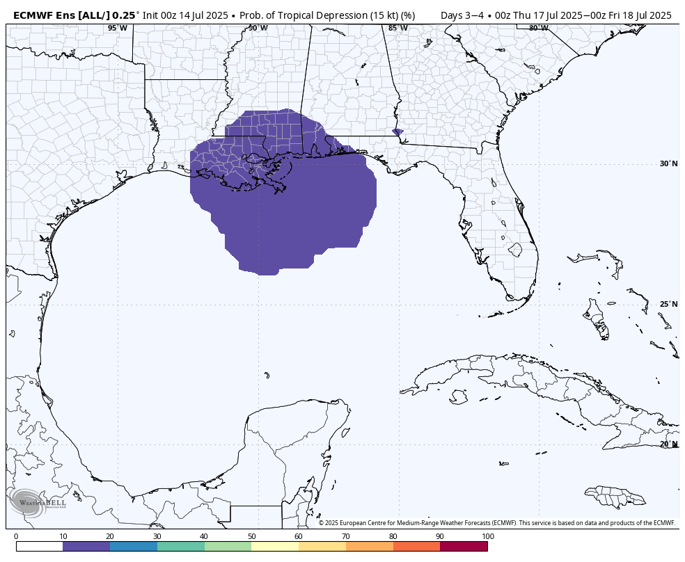
Our guidance is pretty split. Some of our best models don’t develop it at all beyond a tropical disturbance, whereas some of other models (particularly AI-based guidance) is a little more bullish in developing a tropical depression or tropical storm. If that happens, the most likely outcome is that this tropical system plows into southern Louisiana, bringing a high chance of rain there during the second half of this week.
As for Texas in general, and Houston in particular, most likely the major effects (if any) from this system will remain east of our region. However, with the disturbance not even developed, and potential impacts three to five days away, there is not much I’m willing to say for certain. We’ll continue to watch it, but our overall concern level is quite low at this time.

2.75 inches of rain in northeast Brazos county yesterday. Nice lightning show.
The TikTok meterologists are already calling this a Cat 4. This is why I only read you guys. Thanks!
Much like Xwitter, TikTok is a cesspool.
🎯
They’re wrong – it’s gonna be a Cat 5 hitting Freeport from the southeast. With our luck, that is.
Social media is going at it with this hurricane news… thanks for always clarifying here!
Well, if it does materialize to a hurricane, at least no one can claim that they weren’t warned.
If y’all’s overall concern level is quite low at this time, then my overall concern level is quite low at this time.
Oh my. I think he said ‘not much I’m willing to say’. Still early but NHC paints it yellow as far west as Lake Charles. So if it forms, what steers it then – right? Thursday morning … you can watch too.
Shelby: I’ve only looked at Ventusky so far, but as of right now it shows a low end system right around New Orleans Fridayish.
Um my birthday is Friday. NO STORMS THANK YOU.
The low pressure system is still off the Eastern coast of FL (why there’s a yellow “X” over there). The big yellow blob in the Gulf is the anticipated path.
I visited the the Ventuski website and set to Air Pressure. and did ECMWF, ICON, and GFS models separately.
Only ICON showed circulation and eventually passing over New Orleans and Baton Rouge, on Friday.
Hahaha only ICON predicted the Beryl, Houston meeting. No one else – literally. Never assume WXs know the future. One hand for yourself and get a radar app. You’ll get plenty of warning or peace of mind there several days in advance.
Nobody knows the future not even radar apps
With a proper radar app, I can see the current formation well to the east of Daytona Beach. With the wind field toggled on I can see the counterclockwise wind motion north of the rain bands. Over a thousand miles away at this point but I can watch for development and see location in real time. All on my pocket phone! Amazing stuff. I don’t need to predict anything. If it spins up Thursday and starts heading here I know what to think about. Do you?
Radar apps are a useful tool to have for your phone, but it’s also good to have additional reliable weather sources than just rely on one thing. no need to be rude to others DJ
So far this summer has been about as mild as it can get with a rapidly warming world. Sadly we are about to be back to reality now until maybe October.
Ok SH, I still think GHG is a component of and the real rapid warming thing is coming from clean air. Just look at any warming curve. It’s all from 1980! Don’t make sense otherwise. No one really knows the sensitivity of warm to CO2 level. No one. The proof will be if the curve flattens, as the biggest polluter USA has pretty much cleaned up and a new equilibrium is reached, albeit HOT. Insistent dire messages are so ohhh man.
Possibly not. The U.S. temperature maps that have been issued since about May (TWC) have consistently shown this area anywhere from slightly below normal to slightly above normal. So far those maps have been fairly accurate. The new August-October temperature map continues that trend.
July 14th:
Record high: 103 in 1980
Record low: 62 in 1990
Summer 1980 – I’m at two-a-days in August just before senior year in college. It’s in the low 90s here in the Midwest, bad enough, and it’s over 100 in Texas. It suddenly dawns on me that a good number of us are going to be living in the Upper Texas Coast or the Baton Rouge to New Orleans corridor same time next year working in the chemical or refining industries. Shudder.
“..working in the chemical or refining industries” Ugh!
Is this all there is to life?
Life for many is mostly one long depressing toil to retirement, and then it’s just staring out the window waiting for Godot. Best to escape now whilst you still have a free-thinking mind to make a better choice.
Appropos of nothing but my irritation, why don’t Austin & Colorado counties have a representative weather temperature on your maps?
Hmmm … Woody Allen thing I guess 🙂
“your” maps – unclear what “your” is ??
Go to Wunderground dot com website, then select a PWS in your immediate area. We have 10+ to choose from in our area.
“Space City Weather,” amirite?
Hey, Eric, you should text your kids a link to Space City Weather. It’s a great website for no hype weather forecasts. For all the deets on the tropics, send them to the eyewall!