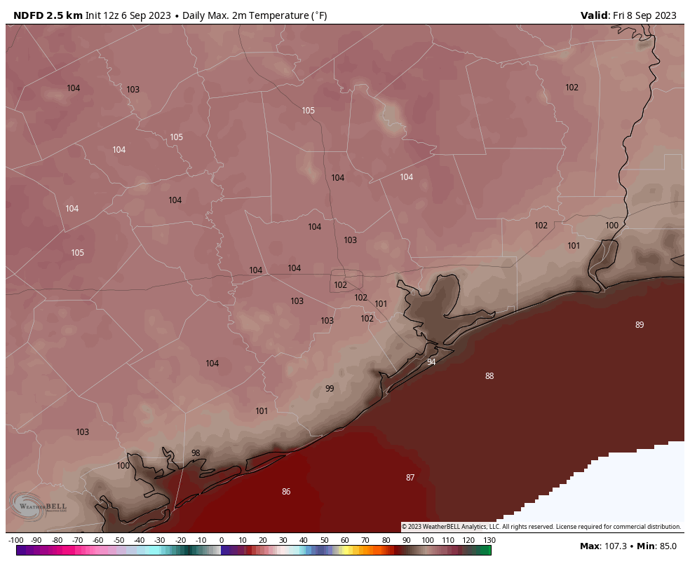
Good morning. High pressure is starting to build back over the Houston region today, and that will lead to four days when temperatures will likely reach 100 degrees, or higher, for most of the region. Friday looks especially hot, with highs near 105 degrees possible for inland areas. But by this weekend high pressure starts to weaken. Accordingly, next week, our temperatures are going down into the mid-90s, at least, and we’ll start to see some better rain chances.
Wednesday
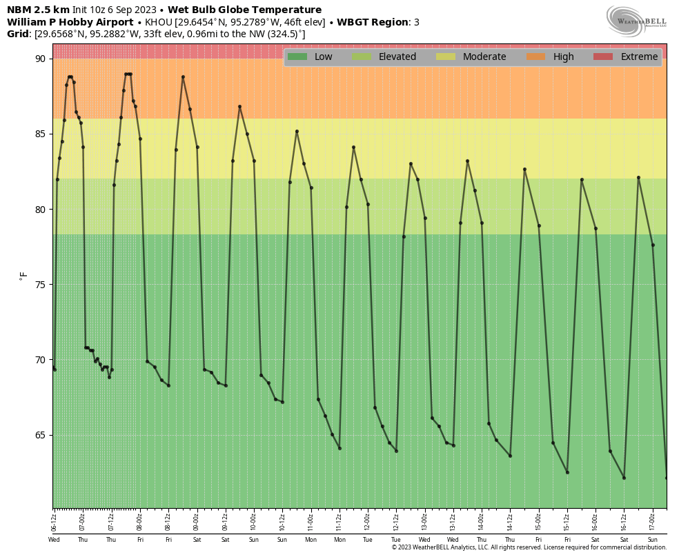
Today will be sunny and hot. Before the high pressure system fully asserts control, we’re going to have a puncher’s chance of rainfall today. I’d say there will be about a 20 percent chance of a brief shower. Otherwise, high temperatures will reach about 100 degrees with mostly sunny skies. Winds will be light, coming from the southeast later today.
Thursday and Friday
Both of these days are likely to bring highs in the low 100s for much of the metro area, with sunny skies. Winds will be light, out of the west to southwest. If I squint, I can see some scenarios in which there are a few isolated showers on Thursday, but it’s not something I’m holding my breath for.
Saturday and Sunday
As mentioned above, Saturday is likely to be the final day, of four, that could see highs of 100 degrees. Conditions will be mostly sunny and hot. However, by then the high pressure system will be easing westward, opening the door to some chances for scattered showers. Sunday should be a bit cooler, with highs in the mid- to upper 90s, and more scattered showers. Call it a 30 percent chance for each day, subject to modification.
Next week
High temperatures next week should be in the range of the low- to mid-90s. We may also see cooler nights, in the 70s. There’s even the chance of a weak front and some slightly drier air. We should also see daily rain chances in the vicinity of 20 to 40 percent. So all in all, quite a bit of moderation from the summer of hell conditions we experienced for most of June, July, and August.
Tropics
As we discussed at length on Tuesday, the Gulf of Mexico remains largely closed off to tropical activity for now, and likely the next two weeks. However there is a potentially very strong hurricane developing the central Atlantic Ocean, Lee, which is likely to eventually threaten Bermuda and possibly interests along the U.S. East Coast. Matt has all of the details on The Eyewall if you want to read more.


Taking “official temperatures” at IAH does most people in Houston no justice. Temperatures should be taken from multiple areas and averaged.
Taking the other side of the coin: When all of the possible areas are “blast furnace hot”, there’s may not be a benefit of taking multiple readings around the area.
That being said, I notice that the daylight hours are tapering down. Less sunlight = less daytime heating, which provides some relief. Now if we could get some rain…
airports tend to have wide open spaces for a accurate reading. Also have been used for decades and have historical data usage
“Drought brings out the worst in us and it’s easy to hate your fellow human beings.” – Luke Davies
The good news is this drought is almost in books. As the strengthening El Niño in the Pacific progresses it should lead to a stronger sub tropical jet over our region. Which if history is a guide will bring us a cooler and wetter pattern.
61 days without measurable rain… just waiting to see my ground grow back together and have my grass be a reasonable shade of green again.
I hope you are right about the final fling.. over the heat for the year, hoping for a wet pattern but not the diaster kind
I’ll be honest, I am shopping around for forecasts at this point. Some are forecasting next week temps ranging from mid 80’s to low 70’s with winds from N/NE. TWC is forecasting low 90’s and low 70’s; I’ll take it!!!
The phrase you want is “a punter’s chance.” Meaning a very small chance
Seems like there’s a split of opinion as to whether it’s puncher or punter from what I can find online.
I’ve only ever heard “puncher’s” chance. I’m not sure how one interprets “punter’s” chance.
Thank you, Eric and Matt, for all your postings of “Hope” during this painful summer of drought. Keep up the outstanding work and service that you do for Houston.
Summer of Hell, indeed!
Could someone smarter than me answer this: is cloud seeding a thing that exists? I know I’ve seen it discussed in different places. For extreme droughts in climates that require rain(like Houston’s), could that be something that’s utilized to alleviate our long running issues?
It exists, but it’s not a paneca for drought conditions. It can’t create moisture out of nothing, so it won’t work on the “blue dome sunny days without a cloud in the sky” conditions that happened quite a bit this summer.
Instead, the ideal oppurtunities would occur on days like yesterday and today, where the cumulus cloud development is strong, but natural storm coverage is isolated at best (this signals that the atmosphere has potential, but needs a bit of help to “tip it over the edge”). Maybe you’ll increase storm coverage from “isolated to scattered” but it still won’t be a drought paneca (storms will still be “hit-or-miss”).
It’s possible that mornings provide another good oppurtunity. This is prior to daytime heating, meaning that conditions aloft are not coupled with surface boundary layer (really shallow in mornings). Many summer days often have morning cloud cover, and seeding those could possibly result in some scattered showers that time as well.
Very good answer. Very well stated. I have been asked this same question before and gave pretty much the same answer you did. Most importantly it depends on the upper air pattern.
Up here Tomball / Magnolia way … it was 84 at 10.30pm last night. Always 100+ during the day. Not ONE drop of rain for weeks. No one’s fault but nature.
Seems the high pressure cell hasn’t moved, even though forecasters state it has. Of course, it’s back again (though it never left)
The best hope is Nov, probably.
As someone who makes their living outside, I am TIRED AS HELL of the heat 🔥🥵 sunscreen bill has never been higher. Get excited by the words, “possible weak cool front”.
I flew into Houston from Detroit this Wednesday evienng. Ah, the balmy breezes and tropical miasma. What struck most was the unsightly dome of pollution over the entire region after flying over beautiful skies of Kansas, Arkansas and, gasp!, Dallas. It’s a shame we have to be enclosed in a putrid overheated sludge. Let it be gone!